Showing 14164 items matching "weather-board"
-
 Kew Historical Society Inc
Plan, Melbourne & Metropolitan Board of Works : Borough of Kew : Detail Plan No.1564, 1905
The Melbourne and Metropolitan Board of Works (MMBW) plans were produced from the 1890s to the 1950s. They were crucial to the design and development of Melbourne's sewerage and drainage system. The plans, at a scale of 40 feet to 1 inch (1:480), provide a detailed historical record of Melbourne streetscapes and environmental features. Each plan covers one or two street blocks (roughly six streets), showing details of buildings, including garden layouts and ownership boundaries, and features such as laneways, drains, bridges, parks, municipal boundaries and other prominent landmarks as they existed at the time each plan was produced. (Source: State Library of Victoria)This plan forms part of a large group of MMBW plans and maps that was donated to the Society by the Mr Poulter, City Engineer of the City of Kew in 1989. Within this collection, thirty-five hand-coloured plans, backed with linen, are of statewide significance as they include annotations that provide details of construction materials used in buildings in the first decade of the 20th century as well as additional information about land ownership and usage. The copies in the Public Record Office Victoria and the State Library of Victoria are monochrome versions which do not denote building materials so that the maps in this collection are invaluable and unique tools for researchers and heritage consultants. A number of the plans are not held in the collection of the State Library of Victoria so they have the additional attribute of rarity.Original survey plan, issued by the MMBW to a contractor with responsibility for constructing sewers in the area identified on the plan within the Borough of Kew. The plan was at some stage hand-coloured, possibly by the contractor, but more likely by officers working in the Engineering Department of the Borough and later Town, then City of Kew. The hand-coloured sections of buildings on the plan were used to denote masonry or brick constructions (pink), weatherboard constructions (yellow), and public buildings (grey). In 1905, when Plan No.1564 was printed, that part of Kew bordered by Brougham Place (now Daniell Place), Mount Street, Sackville Street and Ross Street was already the location of a number of large mansions. Here, subdivisions, at least at this stage, produced larger blocks than in Central Kew. Many of the houses on this plan are named: ‘Faybrook’, ‘Northumbria’, ‘Parkholm[e]’, ‘Dunboe’, ‘Katoomba’ and ‘Eschol’ fronting Sackville Street. Eschol was once the home of the manufacturer Robert Harrison, whose cordial factory in Spring and Argyle Streets Fitzroy are noted on the Victorian Heritage Register. ‘The Hawthorns’ on the corner of Brougham Place and Mount Street was the home of the medical practitioner Frank William Fay, who won the military cross and other honours for conspicuous gallantry and devotion to duty in World War 1.melbourne and metropolitan board of works, detail plans, mmbw 1564, cartography -
 Kew Historical Society Inc
Plan, Melbourne & Metropolitan Board of Works : Borough of Kew : Detail Plan No.1565, 1905
The Melbourne and Metropolitan Board of Works (MMBW) plans were produced from the 1890s to the 1950s. They were crucial to the design and development of Melbourne's sewerage and drainage system. The plans, at a scale of 40 feet to 1 inch (1:480), provide a detailed historical record of Melbourne streetscapes and environmental features. Each plan covers one or two street blocks (roughly six streets), showing details of buildings, including garden layouts and ownership boundaries, and features such as laneways, drains, bridges, parks, municipal boundaries and other prominent landmarks as they existed at the time each plan was produced. (Source: State Library of Victoria). This plan forms part of a large group of MMBW plans and maps that was donated to the Society by the Mr Poulter, City Engineer of the City of Kew in 1989. Within this collection, thirty-five hand-coloured plans, backed with linen, are of statewide significance as they include annotations that provide details of construction materials used in buildings in the first decade of the 20th century as well as additional information about land ownership and usage. The copies in the Public Record Office Victoria and the State Library of Victoria are monochrome versions which do not denote building materials so that the maps in this collection are invaluable and unique tools for researchers and heritage consultants. A number of the plans are not held in the collection of the State Library of Victoria so they have the additional attribute of rarity.Original survey plan, issued by the MMBW to a contractor with responsibility for constructing sewers in the area identified on the plan within the Borough of Kew. The plan was at some stage hand-coloured, possibly by the contractor, but more likely by officers working in the Engineering Department of the Borough and later Town, then City of Kew. The hand-coloured sections of buildings on the plan were used to denote masonry or brick constructions (pink), weatherboard constructions (yellow), and public buildings (grey). MMBW Plan No.1565 is an example of a plan where a number of streets have been created since the area was surveyed, or in other cases renamed. The plan shows those streets that were bordered by Ross Street, Mount Street, Sackville Street and Burke Road. Since 1905, Mawson Street has been created and Mont Albert Road renamed as Dean Street. Named houses on the plan include ‘Tyrol’, ‘Glengorse’, ‘Theodore Villa’, ‘Arncliffe’, ‘Ballynira’ and ‘Hazeldene’. The plan also shows a Wesleyan Church in Sackville Street. In 1883, the Church’s Sunday School celebrated its silver anniversary.melbourne and metropolitan board of works, detail plans, mmbw 1565, cartography -
 Kew Historical Society Inc
Plan, Melbourne & Metropolitan Board of Works : Borough of Kew : Detail Plan No.1568, 1905
The Melbourne and Metropolitan Board of Works (MMBW) plans were produced from the 1890s to the 1950s. They were crucial to the design and development of Melbourne's sewerage and drainage system. The plans, at a scale of 40 feet to 1 inch (1:480), provide a detailed historical record of Melbourne streetscapes and environmental features. Each plan covers one or two street blocks (roughly six streets), showing details of buildings, including garden layouts and ownership boundaries, and features such as laneways, drains, bridges, parks, municipal boundaries and other prominent landmarks as they existed at the time each plan was produced. (Source: State Library of Victoria)This plan forms part of a large group of MMBW plans and maps that was donated to the Society by the Mr Poulter, City Engineer of the City of Kew in 1989. Within this collection, thirty-five hand-coloured plans, backed with linen, are of statewide significance as they include annotations that provide details of construction materials used in buildings in the first decade of the 20th century as well as additional information about land ownership and usage. The copies in the Public Record Office Victoria and the State Library of Victoria are monochrome versions which do not denote building materials so that the maps in this collection are invaluable and unique tools for researchers and heritage consultants. A number of the plans are not held in the collection of the State Library of Victoria so they have the additional attribute of rarity.Original survey plan, issued by the MMBW to a contractor with responsibility for constructing sewers in the area identified on the plan within the Borough of Kew. The plan was at some stage hand-coloured, possibly by the contractor, but more likely by officers working in the Engineering Department of the Borough and later Town, then City of Kew. The hand-coloured sections of buildings on the plan were used to denote masonry or brick constructions (pink), weatherboard constructions (yellow), and public buildings (grey). Plan No.1568 covers the area bounded by Cotham Road, John Street, Sackville Street, and Edward Street. Alfred Street and Rowland Street are in shown in the middle of the plan. The two most notable buildings shown are ‘St Helliers’, the home of the Dumaresq family, and St Hilary’s Church and school. While the colours used to indicate St Hilary’s are grey as in other civic/public buildings, the first St Hilary’s Anglican Church was at this stage constructed in weatherboard. At the left of the plan, facing Sackville Street is a house named ‘Glencara’. The 1988 ‘Kew Conservation Study’ recorded that “The first documentary evidence of this house comes from Rate Books which record that in 1893 a Mrs Treadway was the owner of this building with an N.A.V. of £81? At that date the occupier of the house was Charles B. Kelly, a clerk, while by 1910 Kelly had become the owner of the property described in that year ‘as a six-roomed stone, brick and wood house with stables and outbuildings’”. Contrary to this description, the 1905 plan indicates that the house was entirely constructed of masonry.melbourne and metropolitan board of works, detail plans, mmbw 1568 -
 Kew Historical Society Inc
Plan, Melbourne & Metropolitan Board of Works : Borough of Kew : Detail Plan No.1569, 1905
The Melbourne and Metropolitan Board of Works (MMBW) plans were produced from the 1890s to the 1950s. They were crucial to the design and development of Melbourne's sewerage and drainage system. The plans, at a scale of 40 feet to 1 inch (1:480), provide a detailed historical record of Melbourne streetscapes and environmental features. Each plan covers one or two street blocks (roughly six streets), showing details of buildings, including garden layouts and ownership boundaries, and features such as laneways, drains, bridges, parks, municipal boundaries and other prominent landmarks as they existed at the time each plan was produced. (Source: State Library of Victoria)This plan forms part of a large group of MMBW plans and maps that was donated to the Society by the Mr Poulter, City Engineer of the City of Kew in 1989. Within this collection, thirty-five hand-coloured plans, backed with linen, are of statewide significance as they include annotations that provide details of construction materials used in buildings in the first decade of the 20th century as well as additional information about land ownership and usage. The copies in the Public Record Office Victoria and the State Library of Victoria are monochrome versions which do not denote building materials so that the maps in this collection are invaluable and unique tools for researchers and heritage consultants. A number of the plans are not held in the collection of the State Library of Victoria so they have the additional attribute of rarity.Original survey plan, issued by the MMBW to a contractor with responsibility for constructing sewers in the area identified on the plan within the Borough of Kew. The plan was at some stage hand-coloured, possibly by the contractor, but more likely by officers working in the Engineering Department of the Borough and later Town, then City of Kew. The hand-coloured sections of buildings on the plan were used to denote masonry or brick constructions (pink), weatherboard constructions (yellow), and public buildings (grey). This plan covers parts of Sackville Street, John Street, Thomas Street and Cotham Road, and includes several very large houses in Sackville Street. Job Smith built ‘Berrington’ in about 1888-90 for himself, and ‘Pomeroy’ (now ‘Merridale’) in 1885 for James Mickleburgh. ‘Heathfield’ was built in 1888 for Henry Eeles, and was one of many fine homes in Kew, Hawthorn and surrounding suburbs designed by prolific architect John Beswicke; it later became “La Verna” and was a Franciscan monastery. Similarly, in Cotham Road, we can see ‘Bella Vista’ (now demolished), and ‘Charleville’, with its double-storeyed arcade frontage, built in 1889 for Charles Donaldson whose family occupied it until 1939. This was renamed ‘Ross House’ by the second owner, Dr. Thomas King, and then substantially restored in the 1960s by the Stillwell family, well known as car drivers and dealers. Bella Vista (later ‘Malinda’) was originally designed by the architect Robert Haddon and built for Abel Hoadley, inventor of the Violet Crumble Bar and many other delicious delicacies. He began by manufacturing jams and pickles in South Melbourne using fruit from his own orchard in East Burwood.melbourne and metropolitan board of works, detail plans, mmbw 1569, cartography -
 Kew Historical Society Inc
Plan, Melbourne & Metropolitan Board of Works : Borough of Kew : Detail Plan No.1570, 1905
The Melbourne and Metropolitan Board of Works (MMBW) plans were produced from the 1890s to the 1950s. They were crucial to the design and development of Melbourne's sewerage and drainage system. The plans, at a scale of 40 feet to 1 inch (1:480), provide a detailed historical record of Melbourne streetscapes and environmental features. Each plan covers one or two street blocks (roughly six streets), showing details of buildings, including garden layouts and ownership boundaries, and features such as laneways, drains, bridges, parks, municipal boundaries and other prominent landmarks as they existed at the time each plan was produced. (Source: State Library of Victoria)This plan forms part of a large group of MMBW plans and maps that was donated to the Society by the Mr Poulter, City Engineer of the City of Kew in 1989. Within this collection, thirty-five hand-coloured plans, backed with linen, are of statewide significance as they include annotations that provide details of construction materials used in buildings in the first decade of the 20th century as well as additional information about land ownership and usage. The copies in the Public Record Office Victoria and the State Library of Victoria are monochrome versions which do not denote building materials so that the maps in this collection are invaluable and unique tools for researchers and heritage consultants. A number of the plans are not held in the collection of the State Library of Victoria so they have the additional attribute of rarity.Original survey plan, issued by the MMBW to a contractor with responsibility for constructing sewers in the area identified on the plan within the Borough of Kew. The plan was at some stage hand-coloured, possibly by the contractor, but more likely by officers working in the Engineering Department of the Borough and later Town, then City of Kew. The hand-coloured sections of buildings on the plan were used to denote masonry or brick constructions (pink), weatherboard constructions (yellow), and public buildings (grey). Plan No.1570 shows the layout of gardens and houses in Sackville Street, Davis Street, Wrixon Street, and Fitzwilliam Street in 1904. While Thomas Street is included on the map, at this stage no houses had been built. The plan identifies two named houses: ‘Fairview’ and ‘Kylemore’. Fairview is more fully delineated in Plan No.1563. Kylemore is one of the few houses in Kew designed by John Beswicke. The most notable owner of Kylemore was William Whitehead, who owned the house between 1895 and 1900. In 1894, Australian newspapers reported the marriage of Whitehead’s daughter to Dr. Gerald Eugene Cussen, the brother of Sir Leo Cussen, the Supreme Court Judge. The married couple was to live at ‘Wilton’ (now the Kew RSL) from 1911-15.melbourne and metropolitan board of works, detail plans, mmbw 1570, cartography -
 Kew Historical Society Inc
Plan, Melbourne & Metropolitan Board of Works : Borough of Kew : Detail Plan No.1571, 1904
The Melbourne and Metropolitan Board of Works (MMBW) plans were produced from the 1890s to the 1950s. They were crucial to the design and development of Melbourne's sewerage and drainage system. The plans, at a scale of 40 feet to 1 inch (1:480), provide a detailed historical record of Melbourne streetscapes and environmental features. Each plan covers one or two street blocks (roughly six streets), showing details of buildings, including garden layouts and ownership boundaries, and features such as laneways, drains, bridges, parks, municipal boundaries and other prominent landmarks as they existed at the time each plan was produced. (Source: State Library of Victoria)This plan forms part of a large group of MMBW plans and maps that was donated to the Society by the Mr Poulter, City Engineer of the City of Kew in 1989. Within this collection, thirty-five hand-coloured plans, backed with linen, are of statewide significance as they include annotations that provide details of construction materials used in buildings in the first decade of the 20th century as well as additional information about land ownership and usage. The copies in the Public Record Office Victoria and the State Library of Victoria are monochrome versions which do not denote building materials so that the maps in this collection are invaluable and unique tools for researchers and heritage consultants. A number of the plans are not held in the collection of the State Library of Victoria so they have the additional attribute of rarity.Original survey plan, issued by the MMBW to a contractor with responsibility for constructing sewers in the area identified on the plan within the Borough of Kew. The plan was at some stage hand-coloured, possibly by the contractor, but more likely by officers working in the Engineering Department of the Borough and later Town, then City of Kew. The hand-coloured sections of buildings on the plan were used to denote masonry or brick constructions (pink), weatherboard constructions (yellow), and public buildings (grey). This plan is the other half of Plan No.1571 representing the constructions to the west of Wellington Street before and in 1903/4. This plan represents the built environment in Edgevale Road, Wellington Street, Atkins Street, Annadale Street, Mortimer Street, and Cotham Road. Whereas there are smaller allotments and more modest housing stock facing Edgevale Road, larger blocks and more substantial houses are represented facing Cotham Road.melbourne and metropolitan board of works, detail plans, mmbw 1571, cartography -
 Kew Historical Society Inc
Plan, Melbourne & Metropolitan Board of Works : Borough of Kew : Detail Plan No.1572, 1905
The Melbourne and Metropolitan Board of Works (MMBW) plans were produced from the 1890s to the 1950s. They were crucial to the design and development of Melbourne's sewerage and drainage system. The plans, at a scale of 40 feet to 1 inch (1:480), provide a detailed historical record of Melbourne streetscapes and environmental features. Each plan covers one or two street blocks (roughly six streets), showing details of buildings, including garden layouts and ownership boundaries, and features such as laneways, drains, bridges, parks, municipal boundaries and other prominent landmarks as they existed at the time each plan was produced. (Source: State Library of Victoria)This plan forms part of a large group of MMBW plans and maps that was donated to the Society by the Mr Poulter, City Engineer of the City of Kew in 1989. Within this collection, thirty-five hand-coloured plans, backed with linen, are of statewide significance as they include annotations that provide details of construction materials used in buildings in the first decade of the 20th century as well as additional information about land ownership and usage. The copies in the Public Record Office Victoria and the State Library of Victoria are monochrome versions which do not denote building materials so that the maps in this collection are invaluable and unique tools for researchers and heritage consultants. A number of the plans are not held in the collection of the State Library of Victoria so they have the additional attribute of rarity.Original survey plan, issued by the MMBW to a contractor with responsibility for constructing sewers in the area identified on the plan within the Borough of Kew. The plan was at some stage hand-coloured, possibly by the contractor, but more likely by officers working in the Engineering Department of the Borough and later Town, then City of Kew. The hand-coloured sections of buildings on the plan were used to denote masonry or brick constructions (pink), weatherboard constructions (yellow), and public buildings (grey). Plan No. 1572 represents the built environment bordered by Barkers Road, Wrixon Street, Edgevale Road and Fitzwilliam Street. Other streets identified on the plan include Stansell Street. Plan 1572 shows that by 1903-05, there was only patchy development in this area of Kew, mainly on Edgevale Road and Fitzwilliam Street. Only two named houses are identified: the quaintly named ‘Tweed Cottage’, and ‘Mendip’. The earliest reference to Treed Cottage in Australian newspapers is to the death of Walter Thompson, aged 74 who was a resident there in 1885. His youngest daughter was to die there in 1908. Mendip to the north of Tweed Cottage was owned by Henry Thompson; he was to die in 1901; his wife in 1932. At this period of time, Malin Street and Clivedon Court did not extend to Barkers Road.melbourne and metropolitan board of works, detail plans, mmbw 1572, cartography -
 Kew Historical Society Inc
Plan, Melbourne & Metropolitan Board of Works : Borough of Kew : Detail Plan No.1573, 1905
The Melbourne and Metropolitan Board of Works (MMBW) plans were produced from the 1890s to the 1950s. They were crucial to the design and development of Melbourne's sewerage and drainage system. The plans, at a scale of 40 feet to 1 inch (1:480), provide a detailed historical record of Melbourne streetscapes and environmental features. Each plan covers one or two street blocks (roughly six streets), showing details of buildings, including garden layouts and ownership boundaries, and features such as laneways, drains, bridges, parks, municipal boundaries and other prominent landmarks as they existed at the time each plan was produced. (Source: State Library of Victoria)This plan forms part of a large group of MMBW plans and maps that was donated to the Society by the Mr Poulter, City Engineer of the City of Kew in 1989. Within this collection, thirty-five hand-coloured plans, backed with linen, are of statewide significance as they include annotations that provide details of construction materials used in buildings in the first decade of the 20th century as well as additional information about land ownership and usage. The copies in the Public Record Office Victoria and the State Library of Victoria are monochrome versions which do not denote building materials so that the maps in this collection are invaluable and unique tools for researchers and heritage consultants. A number of the plans are not held in the collection of the State Library of Victoria so they have the additional attribute of rarity.Original survey plan, issued by the MMBW to a contractor with responsibility for constructing sewers in the area identified on the plan within the Borough of Kew. The plan was at some stage hand-coloured, possibly by the contractor, but more likely by officers working in the Engineering Department of the Borough and later Town, then City of Kew. The hand-coloured sections of buildings on the plan were used to denote masonry or brick constructions (pink), weatherboard constructions (yellow), and public buildings (grey). This plan has detailed annotations written in red or blue ink, showing prices, which may be the annual valuations of the properties, and some owners’ names, a most unusual feature on contractor's maps. Some areas, such as the buildings of Methodist Ladies’ College (MLC), include the school’s tennis court and swimming pool, but are not coloured to show building materials – did the draftsman just run out of time, or ink, or enthusiasm, before his plan had to be submitted? MLC had been founded in 1882 as a ‘modern school of the first order’ with buildings that formed ‘a collegiate institution for girls unsurpassed in the colonies’. The goal of its founders was to provide a high-class Christian education for girls, comparable with that provided elsewhere for boys. Some shops are shown along Edgevale Road, though they are not designated as commercial premises. Larger houses are depicted, including ‘Fairlawn’ in Barkers Road, and ‘Clevedon’ and ‘Rosehill’ (now demolished) in Fitzwilliam Street.melbourne and metropolitan board of works, detail plans, mmbw 1573, maps - borough of kew, cartography -
 Kew Historical Society Inc
Plan, Melbourne & Metropolitan Board of Works : Borough of Kew : Detail Plan No.1574, 1905
The Melbourne and Metropolitan Board of Works (MMBW) plans were produced from the 1890s to the 1950s. They were crucial to the design and development of Melbourne's sewerage and drainage system. The plans, at a scale of 40 feet to 1 inch (1:480), provide a detailed historical record of Melbourne streetscapes and environmental features. Each plan covers one or two street blocks (roughly six streets), showing details of buildings, including garden layouts and ownership boundaries, and features such as laneways, drains, bridges, parks, municipal boundaries and other prominent landmarks as they existed at the time each plan was produced. (Source: State Library of Victoria)This plan forms part of a large group of MMBW plans and maps that was donated to the Society by the Mr Poulter, City Engineer of the City of Kew in 1989. Within this collection, thirty-five hand-coloured plans, backed with linen, are of statewide significance as they include annotations that provide details of construction materials used in buildings in the first decade of the 20th century as well as additional information about land ownership and usage. The copies in the Public Record Office Victoria and the State Library of Victoria are monochrome versions which do not denote building materials so that the maps in this collection are invaluable and unique tools for researchers and heritage consultants. A number of the plans are not held in the collection of the State Library of Victoria so they have the additional attribute of rarity.Original survey plan, issued by the MMBW to a contractor with responsibility for constructing sewers in the area identified on the plan within the Borough of Kew. The plan was at some stage hand-coloured, possibly by the contractor, but more likely by officers working in the Engineering Department of the Borough and later Town, then City of Kew. The hand-coloured sections of buildings on the plan were used to denote masonry or brick constructions (pink), weatherboard constructions (yellow), and public buildings (grey). This plan shows several very large houses, particularly along Glenferrie Road, and the area now occupied by Ruyton Girls’ School. ‘Tarring’ (incorrectly spelled here as ‘Karring’) was built for Henry Henty in 1872, on part of his original allotment of 20 acres, and ‘Mount View’, which retains its original building and the fountain in the front garden, is part of Ruyton’s Junior School. The most significant change to Tarring and its grounds since 1903, involve the removal of a number of the outbuildings, including a Burmese temple, bought by Henty from the Burmese Exhibit at the Great Exhibition of 1880. It is shown on the plan as a summerhouse. The two-storey mansion, on the corner of Glenferrie Road and Wellington Street, was built in 1891 by leading architect Alfred White as his own home. Having an initial N.A.V. of £160, the house was purchased by a warehouseman Henry Lister, by 1900, when the N.A.V. was recorded at £111. By the turn of the century the house was known as ‘Comaques’. By contrast, much smaller houses are shown in Scott and Byron Streets, including a tiny Mission Hall in Byron Street, which belonged to the Anglican Church from at least 1903 to 1917.melbourne and metropolitan board of works, detail plans, maps - borough of kew, mmbw 1574, cartography -
 Kew Historical Society Inc
Plan, Melbourne & Metropolitan Board of Works : Borough of Kew : Detail Plan No.1575, 1905
The Melbourne and Metropolitan Board of Works (MMBW) plans were produced from the 1890s to the 1950s. They were crucial to the design and development of Melbourne's sewerage and drainage system. The plans, at a scale of 40 feet to 1 inch (1:480), provide a detailed historical record of Melbourne streetscapes and environmental features. Each plan covers one or two street blocks (roughly six streets), showing details of buildings, including garden layouts and ownership boundaries, and features such as laneways, drains, bridges, parks, municipal boundaries and other prominent landmarks as they existed at the time each plan was produced. (Source: State Library of Victoria)This plan forms part of a large group of MMBW plans and maps that was donated to the Society by the Mr Poulter, City Engineer of the City of Kew in 1989. Within this collection, thirty-five hand-coloured plans, backed with linen, are of statewide significance as they include annotations that provide details of construction materials used in buildings in the first decade of the 20th century as well as additional information about land ownership and usage. The copies in the Public Record Office Victoria and the State Library of Victoria are monochrome versions which do not denote building materials so that the maps in this collection are invaluable and unique tools for researchers and heritage consultants. A number of the plans are not held in the collection of the State Library of Victoria so they have the additional attribute of rarity.Original survey plan, issued by the MMBW to a contractor with responsibility for constructing sewers in the area identified on the plan within the Borough of Kew. The plan was at some stage hand-coloured, possibly by the contractor, but more likely by officers working in the Engineering Department of the Borough and later Town, then City of Kew. The hand-coloured sections of buildings on the plan were used to denote masonry or brick constructions (pink), weatherboard constructions (yellow), and public buildings (grey). Plan No.1575 shows that in the area bounded by Wellington Street, Edgevale Road, Glenferrie Road, and Cotham Road, there had already been significant subdivision of land and houses constructed. As one of the highest points in Kew, as expected, there were already some significant mansions built on large allotments of land. Many of these mansions are identified by name on the plan such as ‘Kelso’, ‘Abbotsford’, ‘Clarendon’ and ‘Ashlyn’ in Cotham Road. Other houses of equal size are unnamed on the plan.melbourne and metropolitan board of works, detail plans, maps - borough of kew, mmbw 1575, cartography -
 Melbourne Tram Museum
Book, Melbourne & Metropolitan Tramways Board (MMTB), "Melbourne and Metropolitan Tramways Board - Rules, Regulations", 1974
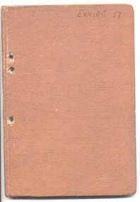
Book - brown Rexene covers, with title - "Melbourne and Metropolitan Tramways Board - Rules, Regulations". single section, sewn into covers, dated 30/5/1957. Sixty Eight pages plus covers. Book numbered "866". Has numerous pasted in updates. Provides rules for both tramway and motor bus operations, has index pages. Provides common rules, and rules specific to buses and trams. At rear is MMTB By-Law 11, dated 1951, and By-Law 16 for lost property. Last two pages provide copy of Certificate of Service. Has been punched on the left hand side with three holes - indicating a possible court document.Marked "Exhibit 17" in ink on front cover.trams, tramways, mmtb, rules, regulations -
 Melbourne Tram Museum
Document - Notice, Tramway Board, "Tramway Board War Loan 5% Bonds, Repayable in 1927", Mar. 1918
Set of 9 notices and other documents concerned with the issuing of "Tramway Board War Loan 5% Bonds, Repayable in 1927". by the Commonwealth Government. Signed W. O Strangward Secretary. .1 - Notice - setting out the conditions, the need, payments - dated 26/2/1918 - 2 copies held. .2 - Notice - application notice - dated 6/3/1918 giving conditions - 2 copies held. .3 - Memo dated 11/4/1918 - on half foolscap, carbon copy, address to all stations regarding extension of the closing date. .4 - Gestetner printed notice dated 27/2/18, forwarding copies of the notices and conditions of the loan and documents. .5 - Quarto printed sheet - Memorandum of Agreement for the employee to signed, giving conditions and signature lines. .6 - Sheet, headed "Tramway Board Melbourne Commonwealth 5% War Bonds" - for each car or power house, listing the names, number of bonds, applicants signature and the amount paid. Double sided, Nos. 104 and 105 .7 - Poster or notice - printed foolscap sheet - advertising the Bonds, and conditions and asking employees to consider. .8 - Memorandum to the Officer in Charge of a particular location, dated 19/9/18, advising of the war loans and associated paperwork. Two copies held. .9 - Form to record payments for the war loans for a particular person, three copies, numbered 496, 497 and 500. Pink cloth back recording the location, name and application number - form No. 530. See also Reg Item 3924 for other documents.trams, tramways, tramway board, world war 1, finances, bonds -
 Ringwood and District Historical Society
Book - Booklet, Gary Presland, Booklet titled 'The Whitehorse Landscape' as seen by the first settlers by Gary Presland, 2011. Contains photographs of flora and fauna plus details of the local weather and geology, 2011
The Whitehorse Landscape as seen by the first settlers contains elements of natural history, geology, weather, local hydrology, vegetation and Fauna. With list of sources, glossary of terms and index. With photographs.25 page booklet, indexed. White covers with picture on front and embedded in the text. +Additional Keywords: Presland, GaryThe Whitehorse Landscape' -
 Melbourne Tram Museum
Document - Memorandum, Melbourne & Metropolitan Tramways Board (MMTB), "Memo to Members of the Board - The Bourke Street - Nicholson Street and Clifton Hill and Northcote Conversion", 13/10/1938 12:00:00 AM
Memorandum, typed foolscap, 8 sheets, titled "Memo to Members of the Board - The Bourke Street - Nicholson Street and Clifton Hill and Northcote Conversion" dated 13/10/1938. The report looks at major English cities, excluding London, transport to developing housing areas outside existing transport links, costs of conversion compared to buses, success of diesel buses (referred to as crude oil buses), construction of new tram lines, use of trolley buses and tables looking at the cost and revenues for each routes, comparison of service levels, capital costs and other factors. Recommends that the Collingwood cable line be closed as soon as practicable. See also Reg Item 934 for a bound copy of his full overseas tour report.trams, tramways, mmtb, bourke st, conversion, double deck buses, tours, overseas tours, buses, trolley buses, uk, costs, housing -
 Eltham District Historical Society Inc
Film - Video (DVD), Melbourne and Metropolitan Board of Works, Yarra River Conference Proceedings; a Board of Works centenary event, 13-16 April 1991
Yarra River Conference History Segment [Noted on VHS tape jackets "Due to unavoidable circumstances, the quality of these tapes in some setions is less than desired."] The Yarra River Conference, organised by the Board of Works as part of the Centenary Celebrations, was held in the Board's Head Office Theatrette from 13-16 April, 1991. A segment of the Conference focussed on the role that the Yarra River has played in relation to the historical development of Melbourne. Conceived and presented by a group of prominent historians as a chronological 'trip down the river in time', and profusely illustrated with slides, this segment traced the various impacts that urban and rural growth, development of marine commerce, recreational uses, and environmental problems have had on the Yarra during a century and a half of European occupation. As no formal written paper of this combined presentation is available, these two video-tapes provide a record for anyone who has an interest in tis fascinating aspect of the Yarra's history. The speakers who combined to present this segment are identified on the cover of Tape 2. Tape 1 (2 hours) 1838-1863 Deputy ?? to Utility Early navigators of the Yarra River; developing the port of Melbourne; the gold rush and its effect on the new colony; punts and bridges; water supply; pollution of the Yarra; the discovery of gold and early settlement of the Yarra valley; floods of 1839 and 1863. 1863-1891 Formation of the Harbour Trust; Coode Canal; pollution of the Yarra by industry; aborigines, gold miners, timber getters in the Upper Yarra areas; bridges; the flood of 1891. Tape 2 ( 1 1/2 hours) 1892-1934: People Begin to See Beauty and Romance to the River Henley-on-Yarra; realignment of the Yarra; MMBW is responsible for a sewerage system; new docks to cope with increased overseas trade; development of recreational parks; new reservoirs; timber production and timber tramways; bushfire; flood of 1934. 1935-1970: The River is Neglected Still, Except When it Proves Useful Bushfirs of 1939; the end of many sawmills; birth of tourism; increased interest in conservation and preservation of land for open space; further augmentation of water supply system; birth of containerisation changes the port; environmental concerns gain momentum. Speakers Dr Tony Dingle *, Department of Economic History, Monash University Dr Carolyn Rasmussen *, History Consultant Prof. Graeme Davison, History Department, Monash University Mr. Tom Griffiths, Lecturer in Public History, Monash Uiversity Mr. Patrick Miller, History Consultant Mr. Colin Jones, Author and Historian * Co-authors of the Board's history, 'Vital Connections'.video recording, yarra river, conference proceedings -
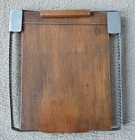 Vision Australia
Equipment - Object, Wooden Braille board
Wooden braille board with wooden header, hinged with brass hinges and small pins to clamp the paper to the board. Metal frames on each side hold a rod across the front of the board. The rod is fixed to two moveable parts which can go up or down the board as required.1 wooden back board with metal flanges either sideroyal victorian institute for the blind, braille equipment -
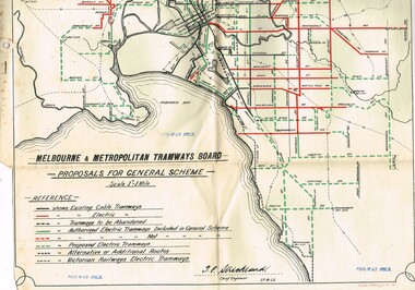 Melbourne Tram Museum
Drawing, Melbourne & Metropolitan Tramways Board (MMTB), "Melbourne and Metropolitan Tramways Board Proposals for General Scheme, c1923
Set of two copies of a drawing with a line back, titled "Melbourne and Metropolitan Tramways Board Proposals for General Scheme". Shows the proposed tram lines submitted to Parliament for the report into the General Scheme. Printed by Sands & McDougall Pty Ltd. Smaller print has been cut and folded for inclusion within the report (see item 2088) and has two punch holes on the side. Has been stamped "Per-Way file" in a number of places. Signed by J. P Strickland dated 27-8-1923. Larger print, original print size has "H. S. McComb" in ink in the top right hand corner. See Reg Item 2088 for actual report. See Reg item 3059 for a separate copy of the map.trams, tramways, mmtb, general scheme, tramways, development, parliament, brighton, railways, map -
 Clunes Museum
Book, Stockland Press, Handbook for Woolgrowers issued by the Australian Wool Board
Handbook for Woolgrowers issued by the Australian Wool BoardBlack leather cover, 88 pages of original text, 2 x brass screws to bind, further pages have been issued by the Wool Board and have been added at a later date. Drench "recipe" for worms in sheep, hand written in black ink, is attached to page 55 by a dressmaker's pin, 2 pages.Handbook for Woolgrowers issued by the Australian Wool Boardaustralian wool board, handbook for wool growers -
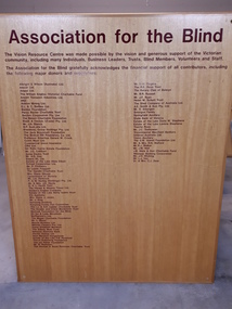 Vision Australia
Photograph - Image, Association for the Blind Vision Resource Centre honour board
The building a Vision Resource Centre at Kooyong was made possible through donations made by a large number of people. To honour this commitment, a board was constructed listing those individuals and businesses who had contributed. During the various refurbishments of the Kooyong site, this board was taken down and is no longer retained.Large wooden board with vinyl lettering"The Vision Resource Centre was made possible by the vision and generous support of the Victorian community, including many individuals, Business leaders, Trusts, Blind members, volunteers and staff. The Association for the Blind gratefully acknowledges the financial support of all contributors, including the following major donors and supporters:" thereafter follows a listing of 93 namesassociation for the blind, fundraising -
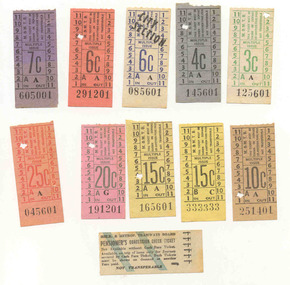 Ballarat Tramway Museum
Ephemera - Ticket/s, Melbourne and Metropolitan Tramways Board (MMTB), Set of 11mixed Melbourne and Metropolitan Tramways Board, late 1960's
Set of tickets collected by Ray Hall, possibly in his days as a MMTB crew member - conductor? - all have starting numbers in "01", except for two with 6 numerals the same. Shows MMTB style tickets of the time - 1966/67?Set of 11mixed Melbourne and Metropolitan Tramways Board tickets with Ray Hall's papers. May have come from time he worked for the MMTB - all decimal. Tickets have been used . Tickets have not been individually numbered with the Registration Number, but can be identified by their ticket number and denomination. See image btm3465i.jpg See Reg Item 3456 for details of his history. 3c - A125601 - green on white paper 4c - A145601 - black on grey paper 6c - City section - A085601 - blue on white paper 6c - A291201 - black on orange paper 7c - A605001 - black on purple paper 10c - A251401 - black on bluff paper 15c - C333333 - black on yellow paper. 15c - A165601 - black on yellow paper 20c - G191201 - green on pink paper 25c - A045601 - red on light red paper. Pensioners Concession Check Ticket - 444444trams, tramways, tickets, mmtb, melbourne, used tickets -
 Melbourne Tram Museum
Legal record, Melbourne & Metropolitan Board of Works (MMBW), "Melbourne and Metropolitan Board of Works - Agree to construction a sewer to Car Barn Preston", 1990 to 1920
Set of our four legal agreements within a set of three brown manila folders: .1 - "Melbourne and Metropolitan Board of Works - Agree to construction a sewer to Car Barn Preston", dated 26/7/1919 with the Fitzroy, Preston and Northcote Tramways Trust - FNPTT, sealed and signed by the Chair, Member and Secretary of the Trust and same for the MMBW. Single sheet, typed both sides with a location drawing. Folder numbered "23". .2 and .3 - "MMBW Sewer Mains - Prahran and Malvern Tramways Trust" - PMTT containing four separate agreements - 20/8/1912, 15/3/1911, 30/4/1909 and 30/5/1914, all folded, sealed and signed documents bound together. Folder number "291 - 292". .4 - ditto with the Melbourne Brunswick Coburg Tramways Trust, MBCTT, dated 23/4/1915 - has various schedules. Folder number "294".trams, tramways, mbctt, fnptt, pmtt, mmbw, construction, depots -
 Melbourne Tram Museum
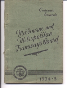
Book, Melbourne & Metropolitan Tramways Board (MMTB), "Centenary Souvenir - Melbourne and Metropolitan Tramways Board - 1934-5", 1935
Book - five sections - 80 pages, side stapled, glued within light green card covers with title "Centenary Souvenir - Melbourne and Metropolitan Tramways Board - 1934-5". Has an introduction, a preface that gives a brief history of the tramway system in Melbourne, 20 buildings and points on interest in Melbourne and how to get there, with sketches by Clive Fink, a list of electrified routes and a cable routes at the time with details of terminals and points of interest along the route. Printed by The Mail Publishers, 264 Barkly St Footscray. See Related documents for a route listing. See Reg Item 79 for a reprint version of 1967. 2nd copy added 29-8-2015 - donation of Ian Bryant. 3rd copy from the McComb Collection added 30-12-2016. Copy 4 donated by Kevin Tiernay - 11-06-2022 Pdf copy added 5/5/2019 as image i2 and images i2 to i4 removed.Has "19" in red ink on inside title page, Copy 3 - has H. S. McComb in pencil along the top of the front cover.trams, tramways, mmtb, melbourne, routes, cable trams -
 Ballarat Tramway Museum
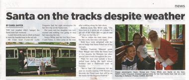
Newspaper, The Ballarat Times, "Santa on the tracks despite weather", 20/12/2018 12:00:00 AM
Newspaper clipping from The Ballarat Times, 20 December. 2018 with an article titled "Santa on the tracks despite weather" featuring a story on the Museum's Santa Tram on Saturday 15 December 2018. Written by Carol Saffer reporting on the event and interviews with a passenger - Sonya White and children. Has a photo of No. 40 with the Santa Tram banner and Roger Salen. Also notes the making of flowers for a flower tram during the 2019 Begonia Festival.santa tram, btm, passengers -
 Vision Australia
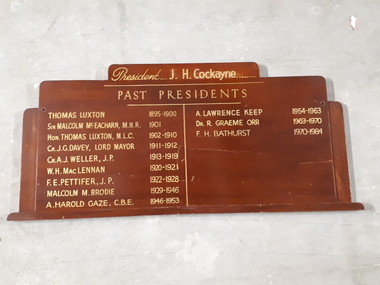
Photograph - Image, Braille Library Presidents board
An honour board listing the current and past presidents of the Braille Library of Victoria, formerly known as the Victorian Association of Braille Writers.Wooden board with gold letteringPresident J.H. Cockayne Past Presidents Thomas Luxton 1895-1900 Sir Malcolm Mc Eachern M.H.R. 1901 Hon. Thomas Luxton M.L.C. 1902-1910 Cr. J.G. Davey, Lord Mayor 1911-1912 Cr. A.J. Weller, JP 1913-1919 W.H. Mac Lennan 1920-1921 F.E. Pettifer, JP 1922-1928 Malcolm M. Brodie 1929-1946 A. Harold Gaze, C.B.E. 1946-1953 A. Lawrence Keep 1954-1963 Dr. R Graeme Orr 1963-1970 F.H. Bathurst 1970-1984 victorian association of braille writers, braille library of victoria -
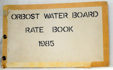 Orbost & District Historical Society
rate books, 1981 -1984
The Orbost Waterworks Trust was constituted under the Water Act 1915 and the Water Act 1916 and gazetted 10th Jan 1917. The Trust consisted of six members who were responsible for the provision of reticulated water to meet the needs of the town. The first reticulated supply to Orbost was installed about 1920. The Trust became part of the Orbost Water Board constituted under the Water and Sewerage Authorities (Restructuring Act) 1983. From 1995 the area has been served by the East Gippsland Region Water Authority. The East Gippsland Region Water Authority was constituted on January 1, 1995. The new Authority assumed responsibility for the services previously provided by the Mitchell Water Board, the Tambo Water Board, the Orbost Water Board and the Mallacoota Water Board. East Gippsland Water is the registered business name of the East Gippsland Region Water Authority. (info. from P.R.O.)These rate books are historically significant as records of an authority which no longer exists having been absorbed by the East Gippsland Water Authority,Four books which contain records of the Orbost Water Board. Each has a hand-made cardboard cover with split pins to hold the pages. The pages are carbon copies and are computer generated. 2551.1 -1981; 2551.2 - 1982 ; 2551.3 - 1983 ; 2551.4 - 1984on front covers : "ORBOST WATER BOARD RATES BOOK" with the year below. -
 Melbourne Tram Museum
Certificate, Melbourne & Metropolitan Tramways Board (MMTB), "Melbourne & Metropolitan Tramways Board - Eastern System - Certificate of Competency as Motorman", 1920
Bound book of 100 Certifications - "Melbourne & Metropolitan Tramways Board - Eastern System - Certificate of Competency as Motorman"". Consists of 100 pages of certificates, numbered 1 to 100, with butt of each certificate retained in the book. Bound with heavy card covers, green coloured on the outside of the covers, stapled with red binding cloth material. Each Certificate numbered, in top left hand corner, with space giving date, employee name, date of birth and signed or initialled by the Manager. On each certificate in the left hand edge is "Swinterton Bros & Co. Printers Melbourne". On each sheet in the top left hand corner is "MMTB/ES Form 105". The printers re-order number "9282" in pencil in the bottom right hand corner of the front cover and printed in the top left hand corner of the certificate. Certifications 1 to 18 and 99 and 100 have been removed - no names or dates inserted which indicates it may not have been used and the sheets torn out for "play" items.trams, tramways, mmtb, htt, motormen, certificates, eastern system -
 Stawell Historical Society Inc
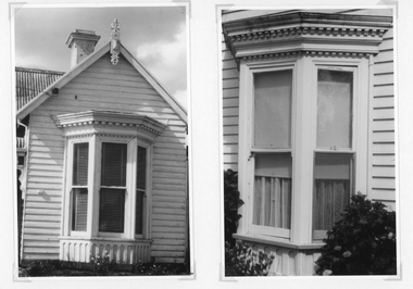
Photograph, Bay Window examples of the Federation House Period -- 2 Photos
Photographs taken to show examples of the detail of a Bay Window in the Federation Period. One photo showing the bay window and weather board surrounding the window. The second photo a detail of the window.Two black & white photographs showing details of the front of a weather board building with a bay window.stawell residence homes -
 Kew RSL
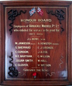
Honour Board, Arbuckle & Ward Honour Board
Advised this board was displayed at Arbuckle's premises in Cato Street Hawthorn. wooden decorative board with wooden ribbon carvings attached in the cornersEmployees of Arbuckle & Waddell Pty Ltd who enlisted for service in the great war 1914-1919arbuckle & waddell, world war 1, hawthorn war memorials -
 Melbourne Tram Museum
Legal record, Melbourne & Metropolitan Tramways Board (MMTB), "Agreement Melbourne and Metropolitan Tramways Board with A.N. Colquhoun", May. 1948
Bound Document, two large ruled grey folded sheets with containing various schedules and letters typed onto foolscap (folio) or quarto sheets. Titled "Agreement Melbourne and Metropolitan Tramways Board with A.N. Colquhoun "signed and sealed on 18th May 1945. Bound on left hand side with green ribbon. Gave Archibald Norman Colquhoun the right to advertising on the inside of tramcars and buses and on the rear of tickets for five years. Gave details of the contract, minimum payments, rebates and conditions of the contract. Schedule A - two pages - space available in tramcars Schedule B - two pages - buses ditto Schedule C - passenger check tickets / annum - some 350million - one page Schedule D - actual tendered document, 15/4/1948 - one page Schedule E - the Specification for the tender - five pages Schedule F - Letter signed by A.N. Colquhoun, on The Reilly Advertising Co. letterhead of which has was the Managing Director giving his credentials. Schedule G - supporting letter on The Reilly Advertising Co letterhead. Schedule H - Letter from the Commercial Bank of Australia Ltd - supporting Mr A.N. Colquhoun. Schedule I - letter from MMTB advising A.N. Colquhoun of his successful bid. Schedule J - Draft agreement in tender document - five pages - signed 15/4/1948."996/7" in top left hand corner of document and stamped "Treasurer"trams, tramways, tickets, advertisements, tramcars, buses, contracts, legal agreements -
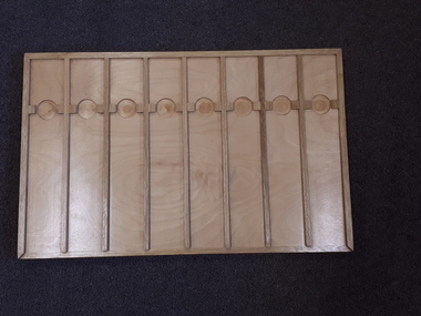 Vision Australia
Object, Patience board, 19
This wooden board has two differently designed sides: one with four strips running the length of the board and the other with seven strips of wood running across the width of the board. These strips and various ridges around the edge and in the 'lanes' assist players as they play card games. The attached booklets describe the sides as Squares (4 strips) or Streets (7 strips), which could be used to play a variety of card games described. On the Squares side: Carpet, Count Nogo, Frames and Poker Patience and on the Streets side: Triangles and Henley could be played in addition to the traditional game of Patience. The board was designed to be used with a distinct sized card (RNIB no. 9087) that could fit between the strips. Wooden board with card dividers with accompanying printed and braille booklet. recreation equipment, games