Showing 146 items matching "whole of school"
-
 Westbourne Grammar Heritage Collection
Photograph - Strathmore Grammar School c.1917, 1986
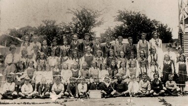
... whole school photograph... to 1956. holy trinity hall strathmore grammar whole school ...In 1914 the Williamstown Grammar School trustees transferred trust in the school grounds and donated the original school building to the Department of Education to establish a state government high school for Williamstown. This meant the dissolution of the Williamstown Grammar school board and the school's senior students either went on to other grammar schools around Melbourne or enrolled at Williamstown High School. Williamstown High School continues today and the original Williamstown Grammar School building is still in use in the school grounds at Pasco Street. This would have been the end of Williamstown Grammar if not for the highly respected young head of the junior school, Mabel Molland. At the Williamstown Grammar School Speech Night at the end of 1914, the Williamstown Chronicle (Saturday 26 December 1914) reports that management of the school has been taken over by Mabel Molland and that she addressed the assembly saying, 'acceding to the expressed wish of many, I decided to carry on the junior school, and wish to thank the parents for their hearty cooperation in my undertaking'. The reputation of Mabel Molland as a teacher of enormous ability and continuing support from the community would enable the school to survive through depression, war and troubled finances, to see the reinstatement of a school board in 1956, the reintroduction of secondary education in 1978 and a now thriving multi-campus independent P-12 school in Melbourne's west. This photograph is the earliest known image of Mabel Molland (standing in the the third row, second from the right) with her students. The group is pictured in the grounds of the Holy Trinity church hall on the corner of Aitken and Pasco Streets, Williamstown, which was home to the School from 1915 to 1956.Black and white reproduction image on photographic paper of students in four rows with trees in the background, a board in the front row with the words Strathmore/Grammar School/Williamstown. Mabel Molland stands at the right and her sister, Mavis Molland, stands at the left.holy trinity hall, strathmore grammar, whole school photograph -
 Ballarat Heritage Services
Photograph - Photograph - Black and White, Chinese Sunday School, Main Road, Ballarat East, 2003
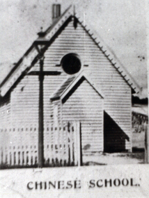
The Chinese School was attached/run by the Town Mission. "THE CHINESE SUNDAY SCHOOL . The opening services of the newly erected Chinese Sunday school building in connection with the Town Mission, were brought to a close on Monday night by a tea and public meeting, held in the Mission Hall. The now building, which presents a very nice appearance, and is an improvement to that part of the Main road, was erected at a cost of £95 ; Mr H. R. Caselli acting as honorary architect, kindly prepared plans, etc. A new front fence was erected at a cost of £l6, which, with all other expenses, amounted to £126 3s 6d. Previously to the present effort collections and subscriptions were obtained as follow; —Mr Burnett's service, £l8 11s 5d; Chinese Sunday school anniversary, £9 16s 10d; concert on Easter Monday, £8 15s; Phoenix Foundry, per Mr Pethard, £7; sub scriptions, £23 8s 6d, leaving a debtor balance of £57 7s 9d. The. collections on Sunday were good. Mr Lee Young, of the Chinese store, Main road, kindly gave the tea, whioh was a valuable donation. The proceeds of the tea meeting will be about £l0. The building was prettily decorated by Mr Chessell, Mrs King Hook, and the gir!s.connected with the sohool. Mr Moorshead, the caterer, gave all the school children tea gratis- Mrs Lee Young, Miss Emma Lee Young. Miss G. Kay, Miss J. Hong Gong, Mrs King Hook, Mrs Stoneman, and Mrs Pethard waited at tables. Mr M. D. Morgan presided at the public meeting in the Mission Hall, and was supported platform by the Mayor of Ballarat East, the Revs. J. White, J. J. Perrin, and E. Turner, who delivered excellent and suitable speeches; but previously, however, offers of donations - to clear off the debt were made by Mr D. Ham, £10; the chairman, £5; Mr and Mrs Whitrick, £2 17s; a number of donors of £1 each, and less sums, which, with the collec tions, amounted to £58 16s 7d. This sum, with the sale of the cottage.on the ground, clears the debt, and leaves the com mittee a few pounds in hand towards lining and seating the building. A pleas ing feature in the meeting was the hearty giving of several Chinese Christians, including Mr Le Young; also singing by the Chinese chil dren, led by Mr Pethard. When the result was made known tbe whole, meeting stood and sang —“ Praise God from whom all blessings flow," for the success in having the place opened free of debt. Votes of thanks were passed to Mr Caselli, and all who took part in the effort: and one of the happiest meetings ever hold by the mission was brought to a close by again singing the doxology and the benediction." Ballarat Star, 27 February 1885)Black and white image of a weather board school known as the Chinese School, Ballarat.chinese school, ballarat, ballarat town and city mission, chinese, education, school, chinese sunday school -
 Wangaratta High School
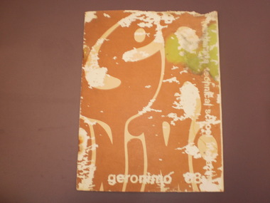
WTS Yearbook -Geronimo, 1968
Brown yearbook with an abstract white pattern. Along the right side is white text reading Wangaratta Technical school magazine, and white writing along the bottom reads Geronimo 68. There is a lot of degradation of the paper cover, with wear across the whole page. The cover has water damage in the top right corner.Wangaratta technical school magazine Geronimo 68 -
 Bendigo Historical Society Inc.
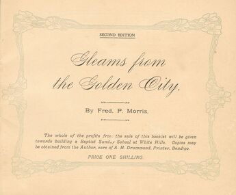
Book - GLEAMS FROM THE GOLDEN CITY BY FRED P. MORRIS 1908
Second Edition of ''Gleams from the Golden City'' by Fred P. Morris. Price one shilling. On front page: The whole of the profits from the sale of this booklet will be given towards building a Baptist Sunday School at White Hills. Copies may be obtained from the author, care of A.M. Drummond, Printer, Bendigo. On Page 2 a dedication to those two venerable servants of God who have influenced my life The Rev.W.C. Tayler of White Hills and Abraham Harkness, Esq. of Golden Square. Acknowledgemt is made to the following subscribers who have helped in publication expenses: His Worship the Mayor of Bendigo (Cr. A. Harkness), Sir John Quick, Senato rMcColl, Hon Joseph Sternberg, Dr. W.J. Long, Dr. J. McIntyre Eadie, Messrs. Barkly Heyett, J. M. Griffiths (Melbourne), J. S. Stewart, C. H. Davis, Vernon Rymer, H. Holmes, A. Dunstan, A. Bush, S.H. McGowan, and I.E. Dyason and Mrs. Thomson (Hamilton). White Hills Bendigo November 1908. On Page 3 a Dedication: Dear Mr. Morris, I wish you success in your effort to further the cause of our Lord Jesus Christ, your friend Charles W. Alexander.book -
 Kew Historical Society Inc
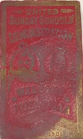
Souvenir, United Sunday schools, Red Leather Bookmark, United Sunday Schools' Demonstration, Melbourne, 6 May 1901, 1901
SUNDAY SCHOOL DEMONSTRATION. With three times three we coo-ee, The Prince we meet again; Our Princess May we welcome, With heart and voice amain. This was the welcome of the children of the Melbourne Sunday schools. The greeting came from over 30,000 youthful voices to the accompaniment of as many waving flags of diminutive size, held by the children. Probably not one of those who sang so lustily had witnessed the previous visit of his Royal Highness; or knew anything of it except as a traditional event, but the sentiment was a good and proper one all the same. The children were massed on the rising ground in the Domain, and apparently the long wait was not at all wearying. It was to most of them a huge picnic. They lunched on the grass, and filled in the intervening lime with games such as the juvenile heart delights in. At intervals something approaching order, was observed, and then songs, which have been in rehearsal for some weeks past, were sung under the baton of Mr. D. R. Davies, musical director, and to the lead of a united brass band of over a hundred instrumentalists under Bandmaster E; T. Code. A solo was also sung by Mr. H. J. Floyd. At all times the scene was an exceedingly animated one. Most of the children were attired in light costumes, and those in whose dress there was some color provided the necessary variety to make up a most picturesque scene. Probably there were nearly 35,000 adults and children at this spot. They occupied the frontage to St. Kilda-road, from Government House gates to the intersecting thoroughfare beyond. As the children were confined to the high ground, there was a green strip in front of them, and the dark green of the fir trees at the top of the slope made a most suitable background. Between these two lines of even coloring the children, with the easy freedom of youth, made perhaps as pretty a feature of the pageant as could be found anywhere in the whole route of the procession." (The Age, Tues 7 May 1901, p.6)This tiny battered piece of ephemera recording the United Sunday School Demonstration of 1901 must once have been exceedingly common, however in the context of the growing collection that the Society has relating to the opening of the first Commonwealth Parliament in Melbourne it has historic and social significance.Embossed red leather bookmark commemorating the 'United Sunday Schools Demonstration' in St Kilda Road in 1901 to welcome the Prince and Princess of Wales to open the first Commonwealth Parliament in the Royal Exhibition Building."United Sunday Schools Demonstration, Melbourne Australia, Melbourne May 6 1901"opening of the first commonwealth parliament - 1901, sunday schools - victoria, federation events - victoria - 1901, ephemera -
 Bendigo TAFE
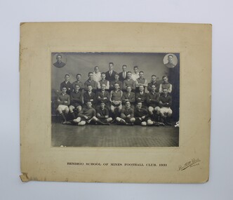
Photo, Bartlett Bros, Bendigo School of Mines Football Club, 1931, 1931
Part of the social history of the Bendigo School of Mines and Industries and an indication of the social clubs that used to operate at the school.Bendigo School of Mines Football Club, 1931. (Black and white photo). Photo is mounted on a backing board. A border of 2 straight lines have been embossed around the photo. These lines are approximately 1 cm from the edge of the photo. Photo has been done by Bartlett Bros Bendigo. Photo is of the whole team with two small individual portraits attached at the top of each corner of the photo. Located underneath the photo “Bendigo School of Mines Football Club, 1931.” Located in the the right-hand corner “Bartlett Bros Bendigo" bendigo school of mines, bendigo school of mines and industries, 1883-1959, bartlett bros, bendigo, football club, bendigo school of mines football club -
 Surrey Hills Historical Society Collection
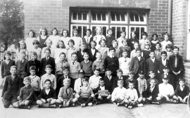
Photograph, Surrey Hills Primary School class photo, Grade 4, 1929, 1929
It is assumed that the donor is amongst the students. The timing of the donation would have prohibited him providing identifying details. This is one of a series of photos donated by Arthur Lyons. Arthur was the only son of Frederick Adolphus Lyons (1891-1980), cab man, born in Surrey Hills, the son of Thomas and Catherine Lyons. Fred married Elizabeth Ruby Hall in 1918. They lived at 55 Sunbury Crescent. The Lyons’ home in Sunbury Crescent was called ‘Knopshambury’ - this was probably a misspelling of Knockshanbally in Co Kilkenny, the birth place of Fred’s father, Thomas Edmund Josias Lyons (1846-1915). Arthur Lyons was born in Surrey Hills on 12 Jun 1920 so would have been 8 or 9 at the time this photo was taken. He became a motor mechanic / welder and lived his whole life at 55 Sunbury Crescent. The donation was made while he was in hospital. He died shortly afterwards (23 Sep 1990). Donation was finalised by a neighbour, Mrs Florence Ann Armitstead, wife of Glen Victor Armitstead. Glen was a local hairdresser. They moved to 11 Sunbury Crescent after their marriage in 1939. Arthur had no relatives to distribute the material to. Black and white photo of a class of 63 children ( 36 male and 27 female children) of Surrey Hills Primary School taken outside the school against a brick wall. Some of the boys are wearing caps. None are identified.SH67schools, surrey hills primary school, education, primary education, children, arthur lyons, arthur frederick lyons -
 Federation University Art Collection
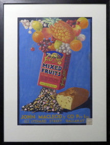
Painting - poster, 'Gold Seal Mixed Fruits' by Betty Brown, c1935
Betty Brown was a student of the Ballarat Technical Art School when she completed this work, most probably for the Wiltshire Poster Competition. In the 1936 Ballarat School of Mines Annual Report it was stated: "It is my pleasure to report a most successful year in the Technical Art School. I the Annual Poster Competition for Technical Schools, organised by Wiltshires Pty Limited, 16 prized valued at 33 pounds 8 shillings - out of 23 prizes valued at 56 pounds - were won by our students. This item is part of the Federation University Art Collection. The Art Collection features over 1000 works and was listed as a 'Ballarat Treasure' in 2007.A framed original gouache poster depicting a box of mixed fruits with whole fruits such as pineapple, oranges, cherries, lemons, apples and grapes at the top of the box, and dried fruits and a fruit cake at the bottomAt the lower edge of the work are the words "John Macleod & Co Pty Ltd. 122 Lydiard Street Ballarat" A sticker on the lower right hand side reads "Exhibit No 8547 Class No 1736"art, artwork, betty brown, brown, fruit, poster, ballarat technical art school, wiltshire poster competition, available -
 Mont De Lancey
Book, Education Department Victoria, Arithmetic for Grade V
This Arithmetic book was compiled by experienced teachers to meet the requirements of the revised course of study in Arithmetic for elementary schools in Victoria, Australia. There are graded examples and the exercises involved use of the four operations with whole numbers. They are related to veryday life wherever possible. Revision exercises are provided as well as extension work for faster-moving students. It is a textbook not to be to be soley used but in conjunction with other teaching of Arithmetic.A green cloth hardcover book with the title printed in black lettering at the top of the front cover. In a circle below is an emblem in black with 'Education Department Victoria'.non-fictionThis Arithmetic book was compiled by experienced teachers to meet the requirements of the revised course of study in Arithmetic for elementary schools in Victoria, Australia. There are graded examples and the exercises involved use of the four operations with whole numbers. They are related to veryday life wherever possible. Revision exercises are provided as well as extension work for faster-moving students. It is a textbook not to be to be soley used but in conjunction with other teaching of Arithmetic.education, textbooks, arithmetic books, government education -
 Kilmore Historical Society
History of England, 1846
Whittaker's improved edition of Pinnock's Goldsmith's History of England, from the invasion of Julius Caesar to the death of George 11., with a continuation to the present time; also, a dictionary, biographical, historical &c. explaining every difficulty, and rendering the whole easy to be understood; and questions for examination at the end of each section: besides a variety of valuable information added throughout the work....Brown leather-bound hardcover book, very worn extremities, tear to upper spine. Embossed cross-hatch design on leather with embossed border. Staining lower right front, loss of colour back & front. Scored damage to front. Flyleaf torn with piece missing upper right. Front hinge separated, binding loose. 2nd flyleaf stained. Foxing and discolouration of page edges. 519 pp. Poor condition.Inside front cover, label advertising Fulton & Knight's Pronouncing Dictionary, 'T & C Buck/1846'. Front flyleaf, ' [missing] Buck/ [indecipherable] school/1846'. Front 2nd flyleaf, 'Thomas Buck/Mounted Constable/Kilmore District/June 1856'.history of england, thomas buck, mounted constable, kilmore -
 Melbourne Legacy
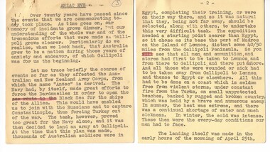
Document - Speech, Copy of address to schools at ANZAC Eve Commemoration at Shrine of Remembrance in 1939 by Legatee President Eric Russell, 1939
A copy of an Anzac Day Address at the Anzac Commemoration Ceremony for Students in 1939, given by the Eric Russell, President of Legacy. It was stored with documents about the building of the Shrine and another speech from a students' service. Legatee Russell had served in World War 1 so was very close to the events he was talking about. The ceremony provides a valuable opportunity for students to gain an appreciation of the Anzac spirit, the significance of the Shrine and the meaning of Anzac Day. The ceremony is usually attended by representatives from schools throughout the state and the Governor of Victoria. The text says: 'Over twenty years have passed since the events that we are commemorating today took place. As time goes on, our memory of incidents grows dimmer, but our understanding of the whole war and of the tremendous efforts that were made at Gallipoli grows clearer. Particularly do we realise, when we look back, that Australia grew to be a nation during those years of anxiety and endeavour, of which Gallipoli was for us the beginning. . . . "A record of a ceremony at the Shrine for school students. The text of the speech is significant in that it was written by a man who had served in World War 1 and knew first hand what it meant to be part of the first Anzacs. Text of a speech at the Annual Anzac Commemoration Service for Students in 1939, typed on foolscap size paper in black ink as well as the original palm cards that were typed on smaller squares of buff colour card. Plus two notes from Legatee Frank Doolan who gave the speech to the Archives committee.anzac commemoration for students, wreath laying ceremony, speech, gallipoli -
 Melbourne Legacy
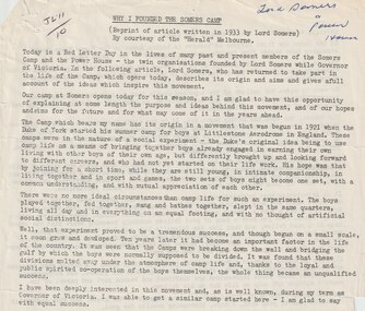
Document, Why I founded the Somers Camp, 1933
A typed reprint of an article that appeared in The Herald. It is an account of the founding of Somers Camp by Lord Somers. The camp began in 1921 when the Duke of York started a summer camp for boys at Littlestone Aerodrome in England. It was an experiment in bringing together boys from different walks of life to encourage understanding and mutual appreciation of each other. While Lord Somers was Governor of Victoria he started a similar camp here with equal success. Part of the text: "Our aim is to change and improve the mental attitude of the boys to each other — to beget a state of mind in which the two sets merge in each other. As the period of the Camp is short — only one week — every effort is made to give the boys full scope for recreation and play. We do not wish to give them a busman's holiday and saddle them with numerous domestic duties, and so they are free of nearly all these, and can devote the whole of their time to themselves. We wish, too, to give them absolute freedom, with as little hampering discipline as possible, and so long as the simple rules of the Camp, such as punctuality at meals and so on are observed, they can do what they like. The Group Leaders take charge of the organised sports, and as each group is composed of boys from both school and workshop, unity is preserved. Superficial differences in worldly pros perity vanish at the Camp; you can't tell one from t'other; a feeling of comradeship in a common life manifests itself; a spirit of loyalty to each other, and to the ideals behind the camp quickly emerges; artificial barriers tumble down, and we are all one, That, in brief, is the spirit of the Camp. But, of course, that is not the beginning and end of it, for if it were, the benefit would be merely temporary, and the effects would pass off. And so I come to the other and, to my mind, the more important function of the movement which finds expression in what we call the Power House. The Power House is a continuation of the Camp. Every boy who attends the Camp becomes automatically a member of the Power House. The Camp is the Open Sesame to the Power House, and whereas in the Camp the boy has merely enjoyed himself, when he graduates to the Power House he begins to imbibe the spirit of service and to learn that he has responsibilities, both to himself and to others. The Power House has already taken concrete form in the shape of a building in the Albert Park which constitutes a sort of headquarters."A record of the camp at Somers in the words of the founder.Foolscap page x 2 of black type of an article in the HeraldHandwritten 'JL11/10' in black pen, 'Lord Somers and Power House' in blue pen.camp, lord somers camp, lord somers -
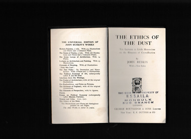 Mrs Aeneas Gunn Memorial Library
Book, George Routledge and Sons, The Ethics of the Dust
The following lectures were really given, in substance, at a girls' school (far in the country); which, in the course of various experiments on the possibility of introducing some better practice of drawing into the modern scheme of female education, I visited frequently enough to enable the children to regard me as a friend. The Lectures always fell more or less into the form of fragmentary answers to questions; and they are allowed to retain that form, as, on the whole, likely to be more interesting than the symmetries of a continuous treatise. Many children (for the school was large) took part, at different times, in the conversations; but I have endeavored, without confusedly multiplying the number of imaginary speakers, to represent, as far as I could, the general tone of comment and inquiry among young people.Index, notes, p.230.non-fictionThe following lectures were really given, in substance, at a girls' school (far in the country); which, in the course of various experiments on the possibility of introducing some better practice of drawing into the modern scheme of female education, I visited frequently enough to enable the children to regard me as a friend. The Lectures always fell more or less into the form of fragmentary answers to questions; and they are allowed to retain that form, as, on the whole, likely to be more interesting than the symmetries of a continuous treatise. Many children (for the school was large) took part, at different times, in the conversations; but I have endeavored, without confusedly multiplying the number of imaginary speakers, to represent, as far as I could, the general tone of comment and inquiry among young people. john ruskin 1819-1900, ethics -
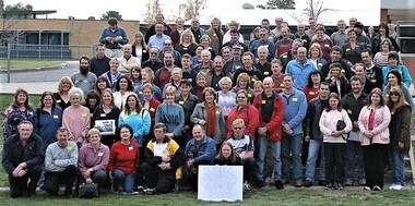 Ringwood and District Historical Society
Photograph, Ringwood Technical School - "Wake"/Reunion 5th June 2005, 2005
Group photo from RTS Wake-Reunion held on Sunday June 5 2005. Liz Seaton organised the event after seeing a post in early May 2005 by another member on a now-defunct website called Schoolfriends / Schoolfriends Reunited, which was very popular before Facebook really got rolling, saying: “Just to let you all know that our old school is being pulled down. You had better get there soon if you want to have a look around before there is nothing left.” Liz notes: A bulk Message was sent from Schoolfriends Reunited to all registered RTS members (about 250) about the Wake-Reunion. The Wake was in the days before the whole area of RTS was fenced off completely from the public. We all met at the front then walked down the driveway, past all the fenced-off vandalised buildings and on to the oval. A very emotional time for all present. After the walk, we finished the day at the Great Ryrie Primary school with afternoon tea, cake (cut by Mr Black, the cleaner) and lots of photos being taken. This is a low resolution group photo. It is hoped to obtain better photos and a video taken by Grant Bickerton on the day - watch this space! Liz Seaton is 2nd row, far left, wearing a blue and yellow top and with much longer hair than now. rts, ringwood tech -
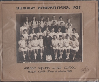 Bendigo Historical Society Inc.
Photograph - Golden Square State School Senior Choir 1927
BENDIGO. Golden Square State school choir won three of the principal shields at the recent Bendigo musical and elocutionary competitions. The choir's victories were celebrated by a social at which the prizes were presented. In presenting the trophies, Mr. R. S. V. Cocking, president of the competitions committee, referred to the popularity of the children's choir contests, which the musical adjudicator, .Mr, James, had characterised as the most important sections on the programme. Of the whole of the competitions held throughout Australia none had a school section to equal that at Bendigo. The head master of the school, Mr. A. M. Parratt,. who conducted the choirs, was presented with a grandfather's clock and photographs of the choirs, by the residents of Golden Square. The Age 23 June 1927Black and white photo of thirty children - twenty five girls and five boys, and one adult male. The girls appear to be all dressed in white dresses and long white socks, and the boys and adult are dressed in suits with white shirts and ties. The adult male is seated centre front with a shield propped in front of his feet. Joan McDonald Collection. Bendigo Competitions 1927 Golden Square State School Senior Choir Winner of the Advertiser ShieldPrinted on the cardboard frame "Bendigo Competitions 1927 Golden Square State School Senior Choir - Winners of the Advertiser Shield" "Kalman 57 & 59 Pall Mall Bendigo".golden square primary school, choir, bendigo competitions -
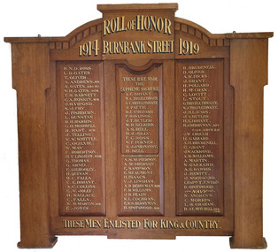 Federation University Historical Collection
Furniture - Object, Burnbank Street Methodist Sunday School Honor Board
This honour board is thought to have been made to a design by a student of the Ballarat Technical Art School, a division of the Ballarat School of Mines. "Honor Boards. — During the past few months very many honor boards have been manufactured by Messrs R. Tunbridge and Sons, and their handsome design and workmanship have given complete satisfaction to purchasers. Some time ago, the firm gave five guineas, for prizes to the architectural class at the School of Mines for the best honor board designs, and some magnificent suggestions were submitted by the competitors. Messrs Tunbridge and Sons, in adopting this plan, gave encouragement to the students to develop along the lines of originality in architecture, and at the same time secure a very fine collection of designs. The whole of the honor boards turned out by the firm are of local manufacture and only the very choicest of Australian timbers are used. As Tunbridge and Sons have made the manufacture of honor boards a speciality they are employing a couple of first-class cabinetmakers on the work of making honor hoards only, and the lettering is also done by a local firm. An honor board which has just been completed by Tunbridge and Sons is at present on view in the firm's window facing Sturt street. It is for Holy Trinity Church, Stawell, is manufactured from Queensland maple, beautifully grained, and is of handsome gothic design. This honor Board is 8 feet in height, and measures 5 feet 6 inches across, and it contains 142 names, including 10 heroes who have won distinctions, and 37 soldiers who have made the supreme sacrifice. Tunbridge and Sons have manufactured honor boards for Miners' Rest:, Weatherboard, Scotchman's Lead, Durham lead, the Buninyong Methodist Church, Ballarat Shire south riding, St. Arnaud High School, Knox Sunday School, and Bungaree Shire Council, and there are boards for the Watchem South State School, and Springdallah in hand. People are realising that there is no need to go to Melbourne for honor boards, which are manufactured by Tunbridge and Sons of superior material, and are better finished and their prices are much below metropolitan rates." (Ballarat Star, 27 April 1918) Geoffrey Blainey's father was the pastor at the Burnbank Methodist church. Geoffrey Blainey became the first Chancellor of the University of Ballarat, a predecessor of Federation University Australia. The Honour Board was removed from the Wendouree Uniting Church when it was closed on August November 2019. Timber honour board for the Burnbank Methodist Church in Ballarat.burnbank street methodist sunday school honor board, world war one, honour board, honor board, wendouree uniting church -
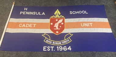 Peninsula Grammar
Flag - Cadet Flag, Peninsula School Cadet Unit Original Flag, 1964
This flag was created in 1964 for the Peninsula Grammar Cadet Unit which would be officially established in 1965. Primarily used for parades and formal events, this original flag is important to the history of the Peninsula Grammar Cadet Unit as a whole. This flag is significant as it is the original flag of the Cadet Unit created prior to the Unit's official formation. Blue flag, red and white stripes with school logo in center. Features the inscription 'T Peninsula School Cadet Unit Est. 1964. Flag is attached to a white pole with a gold top. The Peninsula School Cadet Unit Est. 1964 * note that the T and E are missing in 'THE' cadets flag peninsula grammar cadet unit, flags -
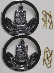 Peninsula Grammar
Badge - Metal Hat Badge, Peninsula Grammar Cadet Unit Silver Metal Badge for Slouch Hat
These Silver Cadet Badges are worn on the front of slouch hats which are traditionally worn by senior cadets for all parades and by the whole unit for Final Parades and formal events (ANZAC Day and Remembrance Day ceremonies). These badges are significant as most cadet units do not have a separate unit badge for their slouch hats and instead wear the similar Australian Army Cadets badge. However, a separate badge is often commonplace within school units as community units will usually display the other badge. 2 x Silver Metal Badge showcasing the Peninsula Grammar logo in a sphere of silver. Possibility for clasps on back and comes attached with two gold hat pins to do so. Peninsula Grammar Logo with engraved 'The Peninsula School Cadet Unit'cadets, cadet badge, peninsula grammar army cadet unit, silver badge, metal badge, australian army cadets, peninsula grammar -
 Bendigo Historical Society Inc.
Certificate - Lutheran Church Certificate, Dec 1894
The Certificate Translation: "Praise the Lord in His Holy Kingdom. All (everyone, everything) praise the Lord." To Pastor F. Leypoldt, Highly esteemed Sir, "We the undersigned for the whole German Lutheran community of Bendigo wish you together with your loving family heartfelt congratulations on your 25 years anniversary. Most heartfelt wishes." Signed by 11 members of the (presumably) Board of management of the Lutheran Church. Some of the names: Wilhelm Scheuffele - farmer, winegrower from Epsom, george Junck - Master builder from Hamburg, Heinrich Holtorf - Hotel keeper, Holtorf's Hotel Hight st Sandhurst, Heinrich Germann - early drapery business of Balsille and Germann, one time organist of the church.Lutheran (German) Church Framed Certificate - Glass frame photo of the Bendigo Lutheran Church given by the board of management to Pastor F. Leypoldt. Certificate has, in the centre a photo of the church, a photo of the Pastor and 11 portraits of the Board of Management. bendigo history, sandhurst, lutheran german church, penny school -
 Stawell Historical Society Inc
Photograph, Whitehall Property Greens Creek
Hutchings family 1. Wimmera River in flood below Whitehall running a banker c. 1920. Ted & Col Hutchings in foreground. 2. Wimmera River in flood looking downstream. No date but possibly same time as no. 1. from same place. 3. Looking over the Wimmera River to Island paddock towards Greens Creek 4. Wimmera River half a banker at Whitehall 5. Wimmera River in flood upstream from carpenter's shop looking towards engine house at Whitehall 5a. Wimmera River in flood. Left to right - blacksmith shop and carpenters' shop. 5b. Taken from the same spot with Emily & Ada Hole, E G (Ted) & Col Hutchings. Blacksmith shop & carpenters' shop, Whitehall. 5c. Wimmera River upstream from the carpenters' shop. Foreground is possibly Belladonna lilies which were all over the river bank in 1992. Whitehall. 5d. Looking downstream towards the loose boxes, Whitehall. 5e. Blacksmiths' shop and carpenters' shop from the pumping station. Wimmera River, Whitehall. 6. Wimmera River in flood at Whitehall. 7. Wimmera River half a banker in front of old hut at Whitehall. 8. Wimmera River Emily Hayes, Edward G (Ted) Hutchings & Colin J Hutchings. 9. Morrl-Morrl - Greens Creek Road opposite back paddock. Whitehall. Black Ford in distance. c. 1919 10. Whitehall woolshed north east aspect, Drive to the right of photo 11. Whitehall woolshed - north east aspect showing the drive to the right 11a. Whitehall woolshed - north aspect 11b. Same tree near woolshed 11c. Same tree again in centre, other trees came up after the 23 flood. Woolshed to the right out of photo. 12. Whitehall woolshed - south aspect, sheep entrance end 13. Whitehall. left to right, Stackyard, stables in the centre and the Wimmera River behind following the trees. 14. Whitehall horse paddock c. 1920. left to right, Machinery shed, stable in the centre. Homestead to the right in distance. There is no windmill. 15. Load of wool from Whitehall woolshed to right. 16. Whitehall c. 1920 before the windmill. left to right, garage and mens' hut. Wimmera river runs along the tree line. 16a. Stables, garage and mens' hut after the construction of the windmill. River behind. 17. Whitehall c. 1922. Note windmill addition. Garage to left, Mens' Hut to right. Jack Donnelly & Edward G (Ted) Hutchings with pet lambs. River behind trees. 18. Whitehall gardens. Summer house to the right, pine tree lined drive in the centre background. Ted & Col Hutchings on the lawn. C. 1920 19. Edward G. (Ted) & Colin J. Hutchings in Whitehall garden. Wimmera River in the background. The building behind the fence is the carpenters' shop which the family lived in while house was rebuilt after fire 15 Jan 1877 20. Whitehall c. 1920. left to right, cattle yard, killing house, Wimmera river behind the fence, and the loose box on the right. Black Orpington chooks in foreground. 21. Bay window (original blinds) in the master bedroom. Whitehall 20 Sep 1992 22. Master bedroom (original wallpaper) Joyce & Col Hutchings, Moyu, Ben & Rebecca Roe 20 Sep 1992 23. Col & Ted's bedroom (original) Marble mantlepiece had been removed. Whitehall. 20 Sep 1992 24. Whitehall kitchen. Large yellow meat oven to left of stove, bread oven far left, extreme right is oven where milk heated to skim cream. Chimney was a central one shared with meat oven. Bread oven chimney separate. 20 Sep 1992 25. Whitehall dairy, made of natural stone with dried brick corners. Entrance behind creeper which is over trellis. 20 Sep 1992. This building still remains in 1 Jun 2023 26. Inside charcoal lined meat cellar. Bottom right is concrete vat for pickling meat in brine. Top of brickwork slightly above ground level. Whitehall 20 Sep 1992 27. Fire foreground was stable flooring which was to left of photo. Machinery shed (thatch roof). 4 posts far left remains of cowshed. Large post in centre foreground is the gate post of corral. River to right. 20 Sep 1992 28. Whitehall machinery shed. Posts on far right are cow shed. Over the river is the island paddock. Wimmera river runs behind machinery shed. 20 Sep 1992 29. Posts of 10 sided corral. Killing house by side of gum tree in centre of photo on far side of corral. To left is one of the bales of the cowshed. Whitehall. 20 Sep 1992 29a. Similar photo in the 1920's. To the right is horsebreaking corral, then cow shed, loose box, haystacks and stable on left. Whitehall. 30. Dining room fire place put in the open fire of the mens' hut, only the chimney remains. To the left is the drive & river. Rebecca Roe, Col Hutchings granddaughter. 20 Sep 1992 30a. Looking down the Whitehall Drive. Mens' Hut (Jack Donnelly in doorway) and garage far left. 1920's 30b. The Drive, Whitehall taken from in front of the mens' hut. Wimmera River on the left. Gum tree on left still there 20 Sep 1992. 30c. Reverse from 30a. Whitehall drive from the front gate looking towards the mens' hut and garage. c. 1926 30d. Curly Donohue leaving for Warracknabeal. Ex mail contractor Omeo to Bright Victoria. C. 1926 30e. Looking down the drive towards front gate. Mens' hut on the right, river on the left. 31. Whitehall from the side. Building in centre behind David is separater room. 2 roomed hut to left of separater room and remains of mens' hut chimney. Photo 16 taken from similar spot. 20 Sep 1992 32. Benjamin Roe (Col Hutchings grandson) in the Carpenters' shop. The family lived in this building after the fire in the 1870's. Whitehall 20 Sep 1992 33. Ford across the Wimmera River at Whitehall (River abt. 5 feet higher than normal) 20 Sep 1992 33a. Wimmera River, Whitehall 34. Site of old bridge before Col Hutchings time. Tree in foreground to right still has bolt from bridge work protuding. A large post was in the centre of photo to make equal distance. 20 Sep 1992 35. Entrance to the old ford. Colin J Hutchings & his daughter, Moyu Roe. Wimmera River, Whitehall 20 Sep 1992 36. Summer house at Whitehall 20 Sep 1992 looking down to the orchard, dark green trees in distance old fruit trees. 36a. Edward & Colin Hutchings in front of the Summer house, Whitehall c. 1921 36b. Summer house looking towards front gate. Whitehall. 36c. Grey thrush in nest box which can be seen in previous photo with summer house in the background. Whitehall. 36d. Summer house from the orchard side. Whitehall. 37a. South side of Whitehall. First window Edith Sutherland's room, 2nd window, Ted & Col's room, bay window master bedroom 38. Taken in middle of front path looking towards front gate. Edith Sutherland in garden. Date palm in centre, cotton palm to left. Whitehall c. 1920's 38a. Garden at Whitehall taken from near the cotton palm. 39. Whitehall 20 Sep 1992 Bay window-master bed, small window to r. of bay-Colin Hutchings born in, front door, window to right-dining room, round the corner- drawing room, window on right, spare bed, verandah on left is spare bed. 39a. Whitehall c. 1920's Date palm on the right. 39b. Win, Colin T & Colin J Hutchings. Date palm in background. Whitehall 1943 39c. Edward George, Colin Thomas, Elizabeth Ambler & Colin James Hutchings wearing RAAF uniform. Date Palm in background. Whitehall c. 1943 39c. Front garden of Whitehall looking from the front right side of the house towards the drive & Wimmera River. Date palm on right, cotton palm on left 20 Sep 1992 40. Taken from bottom left corner of front garden looking towards the summer house. Cotton palm on right. River to the left. 41. Elizabeth A Hutchings beside master bedroom window. Whitehall c. 1920 42. Whitehall (photo of a painting by Wallace) owned by Colin T Hutchings 1982. 42a. Whitehall painting by Wallace after restoration now owned by Nick Hutchings 2021 42b. Whitehall c. 1923 42c. Taken from the side garden looking towards the right side of house. Front door is to the left out of photo. The cotton palm is to the left. c. 1923 43. Signpost showing Whitehall 20 Sep 1992, All ground up to the tree line behind the signpost was Whitehall property. 44. Colin T. Hutchings age 9 mths. Mar 1943 Whitehall 45. Colin James, Elizabeth Ambler & Edward George Hutchings. Front garden by the date palm, Whitehall c. 1939-40 45a. Colin James, Edward George, Edward Thomas Hutchings & E. Winifred May & Barney (dog) Whitehall. c. 1939-40. 45b. Colin James & Colin Thomas Hutchings during drought & World War ll c. 1944-45 in front of cotton palm, date palm to right. 46. Garden at Whitehall. Jack Donnelly on the hand mower. Cotton palm on left, date palm behind Jack and roof of carpenters shop to right. 47. Colin J Hutchings on tractor, E. Tom Hutchings behind. Whitehall, c. 1933 48. Jack Donnelly (Tad) & Colin J. Hutchings. Cotton palm to right. Whitehall c. 1917-18 49. Edward G (Ted) & Colin J Hutchings with cockatoo outside the dairy in rear garden. Whitehall c. 1923 50. Taken from the windmill looking across the roof of the mens' hut to the garden, orchard and drive in Winter time. House is behind the trees to right, Wimmera River to the left out of picture. Whitehall. 50a. Not labelled by Col Hutchings. It is an aerial shot looking towards the house in the trees & seems to be taken from the top of a tree...on the river side. 51. E. Tom Hutchings & George Chambers dam sinking. Whitehall. 51a. Tom Hutchings & George Chambers dam sinking. Whitehall. 51b. E. Tom Hutchings dam sinking. 52. Emily Hayes & Ada Hole (sisters) with Tom, Col & Ted Hutchings at the woolshed. 53. E T (Tom) Hutchings on reaper & binder. Whitehall. 54. Orchard looking towards the house. Carpenters' shop and river on the right. Whitehall. 54a. Orchard looking from the house, dark trees in background form part of the drive. 55. Grasshopper plague, Christmas Day 1933. Whitehall 56. Frost on the front lawn, Whitehall. 57. Little red hen & chicks with the river in the background 58. Edward (Ted) G. Hutchings muscovy ducks, hay shed and trees along the river in the background. 58a. Edward (Ted) G Hutchings muscovy ducks. 59. Swimming in the Wimmera River, either Ted or Col Hutchings in the foreground. 60. Looking towards the fowl house and pigsty, Whitehall. 61. Snake on the path, Whitehall. c. 1923 61a. E. Tom Hutchings killing a snake, Whitehall. c. 1923 61b. E. Tom Hutchings killing a snake, Whitehall. c. 1923 62. Notice of clearing sale, Stawell News & Pleasant Creek Chronicle on 5 Apr 1916 where the stock & whole of the household furniture was to be sold by James Hutchings widow. 63. Back to Greens Creek 7 Jun 1987 Colin J Hutchings left and Belle Kindred centre looking at photo 64. Back to Greens Creek 7 Jun 1987 Colin J Hutchings centre, Graham Stewart holding photograph on the right. 65. Colin J Hutchings & Bill Walker. Back to Greens Creek 7 Jun 1987 66. Colin J Hutchings delivering a speech before the plaque unveiling. Back to Greens Creek 7 Jun 1987 67. Graeme Williamson & Colin J Hutchings (2 'old boys') Greens Creek School Site 7 Jun 1987 68. Graeme Williamson talking to Moyu Roe (Hutchings) in background is May Williamson. Back to Greens Creek 7 Jun 1987 69. Greens Creek SS, Edward (Ted) & Colin J Hutchings attended. 70. Original students of first Greens Creek School 7 Jun 1987 Back row left 1. Kindred 3. Colin J Hutchings 4,5,6 not known 7. Graeme Williamson Sitting left 1. Not an original 2,3,4, not known 5. Belle Kindred 71. Terrier at Greens Creek State School 72. The new school students Back to Greens Creek 7 Jun 1987. Perry twins standing in centre and the teacher kneeling front left. 73. Will Rees water colour 1925 signature 74. Will Rees water colour 1925 75. Shearing at Kirkellar. Allen Simpson's 76. Back to Greens Creek 7 Jun 1987 Colin J Hutchings left and Belle Kindred centre looking at photo 77. Back to Greens Creek 7 Jun 1987 Colin J Hutchings centre, Graham Stewart holding photograph on the right. 78. Colin J Hutchings & Bill Walker. Back to Greens Creek 7 Jun 1987 79. Colin J Hutchings delivering a speech before the plaque unveiling. Back to Greens Creek 7 Jun 1987 80. Graeme Williamson & Colin J Hutchings (2 'old boys') Greens Creek School Site 7 Jun 1987 81. Graeme Williamson talking to Moyu Roe (Hutchings) in background is May Williamson. Back to Greens Creek 7 Jun 1987 82. Greens Creek SS, Edward (Ted) & Colin J Hutchings attended. 83. Original students of first Greens Creek School 7 Jun 1987 Back row left 1. Kindred 3. Colin J Hutchings 4,5,6 not known 7. Graeme Williamson Sitting left 1. Not an original 2,3,4, not known 5. Belle Kindred 84. Shearing at Kirkellar. Allen Simpson's 85. Terrier at Greens Creek State School 86. The new school students Back to Greens Creek 7 Jun 1987. Perry twins standing in centre and the teacher kneeling front left. Digital Copy of Parish Maps Kara Karahomestead -
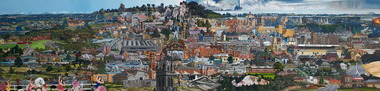 Federation University Art Collection
Painting, Searle, Ken, 'Ballarat' by Ken Searle, 1998
Ken SEARLE (1951- ) Born Sydney, New South Wales Ken Searle worked on this commission through 1997 and 1998. Further works and sketches relating to this commission are held by the Art Gallery of Ballarat. Searle is a self-taught artist who first exhibited his paintings and drawings in the mid-1970s and is known for large, and often whimsical, paintings, of suburban and industrial areas in several Australian cities. From 1998 to 2001 Searle worked as a consultant at the school in the Aboriginal community of Papunya, Central Australia. This item is part of the Federation University Art Collection. The Art Collection features over 2000 works and was listed as a 'Ballarat Treasure' in 2007.Framed painting highlighting the artist's favoured aspects of Ballarat. Interested with scenes of suburbia for over twenty years, Ballarat is his first portrayal of a whole city. Searle’s view of Ballarat presents a deliberately untidy city seen from a number of viewpoints. Local scenes are portrayed no matter how pretty or garish, the subject matter providing a snap shot in time. Funded through the Commissions Program of the Visual Arts/Craft Fund, 1998 art, artwork, ken searle, ballarat -
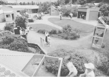 University of Melbourne, Burnley Campus Archives
Album - Black and white and colour prints, negatives and 35mm slides, Kodak, Energy Education Centre, 1989-1996
The Energy Education Centre in the Field Station 1) Black and white photograph of whole of Energy Education Centre. (2) 19 colour photographs of school visit labelled "education Nov '95." (3) 4 sets colour slides, some labelled. (4) 1 colour negative. (5) 67 colour photographs, several different sets, showing construction of the EEC (1988) in envelope labelled "Energy Victoria." (6) 46 black and white photographs, several different sets. (7) 2 sets black and white proof sheets and negatives. (8) 33 colour photographs labelled "Open Day at EEC 22/3/92. (9) 60 colour photographs, several different sets, some labelled, some of staff training? (10) Sets of negatives, unable to match with prints. Some scanned. energy education centre, school visit, energy victoria, open day, eec, field station, orchard -
 Bendigo Historical Society Inc.
Letter - MERLE HALL COLLECTION: ROSALIND PARK CREATIVE VILLAGE BENDIGO PROJECT LETTERS, 1994
Merle Hall Collection: Rosalind Park Creative Village Bendigo Project Letters 31 March 1994 To: Victorian Arts Council Members From Grant Finck Project Coordinator Content: Introduces himself as the coordinator for 12 months; to members looking for expression of interest, includes Information Sheet 1994 on what the Creative Village is. 27 October 1995 To: Mrs. Mearle Hall From: City of Greater Bendigo, Bernard Smith (Director Environmental Services) Content: Granting access to the Victoria Hill site for small quantities of geological material. 10 January 1996 To: Mrs. Mearle Hall From: City of Greater Bendigo, Bernard Smith (Director Environmental Services) Content: Endorsement of the project by the Council and confirmation that the Council will provide preliminary site work to allow the project to be enabled. Also advised the Arts Bendigo Mosaic Project makes contact with the Salvation Army (New Work Opportunity Project) 27 February 1996 To: Mrs. Mearle Hall From: Ken Beasley Manager Project Development The Smith Read Training Group. Content: LEAP Project Proposal - Mining Heritage Mosaic outlining the benefits of using LEAP Trainees to undertake the project. Proposed Scope of work outlining responsibilities of each participant. Bendigo Mining NL Environmental Trust Fund (Perseverance Exploration and Department of Energy and Minerals Victoria representatives) 27 June 1996 To: Mrs. Mearle Hall From: City of Greater Bendigo, Bernard Smith (Director Environmental Services) Content: Advising that the Council will match dollar for dollar funding for the engagement of an artist to supervise the construction of the Mosaic in Upper Rosalind Park up to $3,500. 22 July 1996 To: Anne Buzza From Geof Brown Camp Hill Primary School Content: Thanks for using and managing the school students to help create tiles. 9 October 1996 To: Mrs. Mearle Hall From: City of Greater Bendigo, Bernard Smith (Director Environmental Services) Content: Enclosed cheque for matching grant of $3500 15 October 1996 To: Mrs. Mearle Hall From: City of Greater Bendigo, Bernard Smith (Director Environmental Services) Content: Agreement to relocate the project facilities to the car park and to maintain a close liaison between the Council and Arts Bendigo. 13 November 1996 To: Mrs. Mearle Hall From: The Sidney Myer Fund Helen Morris Research Officer Content: Remittance advice for $1000 22 April 1997 To: Mrs. Mearle Hall From: John Little Administrator Victorian Arts Council Content: Remittance advice for $500 towards the project and enclosing 12 VAC Annual reports. 20 October 1998 To: Mrs. Mearle Hall From: City of Greater Bendigo, Andrew Hall (Director Community Development) Content: Advising that the Council will make a grant of $1090 for the purpose of printing of Brochures for Bendigo Heritage Mosaic. A service agreement to be signed before the issue of the grant, 21 March 2001 To: Mrs. Mearle Hall From: City of Greater Bendigo, Justin Hanney (Director Community Services) Content: A reference from Council supporting the project application to Vic Health for the development of a series of small mosaic pieces along the linear pathway asjacent to the Bendigo Creek. 12 November 1996 To: Mrs. Mearle Hall From: Arts Bendigo Inc. Content: Cheque for $2000 being first payment as under contract two for mosaic project. 4 December 1996 To: Mrs. Mearle Hall From: Arts Bendigo Inc. Content: Cheque for $2000 being second payment as under contract two for mosaic project. 27 July 1997 To: Maery Gabriel Mosaic Artist From: Arts Bendigo Inc. Content: Cheque for $2000 being final payment as under contract two for mosaic project. 12 June 1997 - Two copies To: Maery Gabriel Mosaic Artist From: Arts Bendigo Inc. Content: Agreement between Maery Gabriel (The artist) and Arts Bendigo Inc. to complete the final two sections of the Bendigo Heritage Mosaic at the base of the Rosalin Park Poppet Head, Bendigo with a design of approximately two square meters within each section. The work to be completed by the endo of July 1997, unless severe weather conditions make the laying impossible. Agreement for two lots of $2000. 14 June 1996 From: Maery Gabriel Mosaic Artist To: Arts Bendigo Inc. Content: receipt for 50% payment for two weeks and $60 Travelling expenses. 21 May 1996 Agreement between Arts Bendigo of P.O Box 563, Bendigo in the State of Victoria (hereinafter referred to as the ‘AB’ of the first part AND Meary Hall of Morningswood, Petersons Road, Ellinbank, 3821 in the State of Victoria (hereinafter referred to as ‘the artist’) of the second part. ENGAGEMENT: (a) AB engages the Artist to provide her services as Mosaic Artist for the design and creation of a Mosaic pavement surround to the poppet head lookout in Rosalind Park, Bendigo and matters incidental thereto at such schools, halls and any other places as required from time to time by AB and the Artist accepts the engagement upon the term and conditions hereinafter appearing. (b) Services to be provided by the artist include community consultation and design work in association with AB Co-Ordinator and Arts Bendigo, a minimum of six weeks of the artist’s time within the six months of the project. Completion of section one of the whole design with further work on the other sections to depend on available funding. The agreed fee was $5400 and $60 per visit to Bendigo with living away to be provided by Arts Bendigo 1 November 1996 Agreement between Arts Bendigo of P.O Box 563, Bendigo in the State of Victoria (hereinafter referred to as the ‘AB’ of the first part AND Meary Hall of Morningswood, Petersons Road, Ellinbank, 3821 in the State of Victoria (hereinafter referred to as ‘the artist’) of the second part. ENGAGEMENT: (a) AB engages the Artist to provide her services as Mosaic Artist for the design and creation of a Mosaic pavement surround to the poppet head lookout in Rosalind Park, Bendigo and matters incidental thereto at such schools, halls and any other places as required from time to time by AB and the Artist accepts the engagement upon the term and conditions hereinafter appearing. (b) Services to be provided by the artist include community consultation and design work in association with AB Co-Ordinator and Arts Bendigo, a minimum of six weeks of the artist’s time within the six months of the project. Completion of section one of the whole design with further work on the other sections to depend on available funding. The agreed fee was $5000 and $60 per visit to Bendigo with living away to be provided by Arts Bendigo, plus transfer of the diamond saw purchased by AB 28 August 1996 Memorial to Bendigo’s Mining Heritage and Traditions financial and other support as at August 128th Arts Bendigo Financial contribution: $7000 Local Busine Sponsors: $2800 City of Greater Bendigo Matching Above: $2800 City of Greater Bendigo Site works: Equiv, $12000 Local Businesses and institutions supplying goods and services to total value of: Equiv: $7600 Expenditure: Purchase of equipment, including diamond saw: $2000 Purchase of materials: $800 Artists design fees: $3000 Artists on site work, travel and accommodation: $12000 insurance, administration etc.: $700 31 May 1996 List of possible donors' checklist Undated Budget Sheet 21 September 1995 From: The Victorian Arts Council To: City of Greater Bendigo Content: Invoice for $5000 10 December 1995 From: Maery Gabriel artist To: Arts Bendigo Content: Invoice $1575 for design of Rosalind Park Lookout. 45 hours @ $35/hour 1 October 1996 Historic mining Mosaic Pavement, Rosalind Park Poppet Head Financial Statement as a October 1st, 1996 28 October 1996 From: Maery Gabriel To: Ann Buzza (representing Arts Bendigo) Report on project of Rosalind Park Mosaic as at October 1996. The report lists the difficulties faced with the weather, unsuitable facilities on site and problems with the LEAP team labour.victorian arts council, city of greater bendigo -
 University of Melbourne, Burnley Campus Archives
Plan, School of Horticulture - Burnley, 1957
(1) Plan of whole site dated 22.05.1957, marked into different areas by letter with key for size of area, proposed new buildings, existing permanent and temporary buildings. New inclusion of about 1 acre hand drawn (behind Administration Building). "Burnley Areas," handwritten on reverse. (2) Handwritten notes (T.H. Kneen): Table with area, size sq ft, size acres, of Stockman's Cottage, Grazing area, Ornamental, New extension, Crops - Controlled by School (Plant Breeding, Agrostology, Biology, Egg-laying Competition) - Controlled by Other Branches. From T.H. Kneen files. On same plan as B91.0484 (original) and B91.0476.t.h. kneen, burnley gardens, burnley school of horticulture, stockmans' cottage -
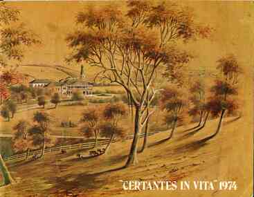 Broadmeadows Historical Society & Museum
Booklet - School Yearbook, Salesian College, Rupertswood, "Certantes in Vita" 1974, 1974
School yearbook, presenting details of the events and students of Salesian College, Rupertswood, Sunbury.A stapled, card-covered, forty-eight-page book with loose card cover. Oil stain bottom right of page 11 and bottom left of p.12.non-fictionSchool yearbook, presenting details of the events and students of Salesian College, Rupertswood, Sunbury.salesian college, rupertswood, sunbury, yearbook, "certantes in vita", 1974 -
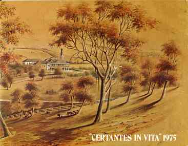 Broadmeadows Historical Society & Museum
Booklet - School Yearbook, Salesian College, Rupertswood, "Certantes in Vita" 1975, 1975
School yearbook, presenting details of the events and students of Salesian College, Rupertswood, Sunbury.A stapled, card-covered, forty-eight-page book with loose card cover. Oil stain bottom right of page 11 and bottom left of p.12.non-fictionSchool yearbook, presenting details of the events and students of Salesian College, Rupertswood, Sunbury.salesian college, rupertswood, sunbury, yearbook, "certantes in vita", 1975