Showing 158 items
matching wood's point road
-
 Marysville & District Historical Society
Photograph (Item) - Black and white photograph, Cumberland Falls, c1900
... -Wood's Point Road. Cambarville is notable for its giant mountain ...An early black and white photograph of Cumberland Falls near Marysville in Victoria.An early black and white photograph of Cumberland Falls near Marysville in Victoria. These falls are located on the Marysville-Wood's Point Road. Cambarville is notable for its giant mountain ash (Eucalyptus regnans) trees within the Cumberland Memorial Scenic Reserve, and relics from former sawmills and gold mining. The Big Culvert is located nearby on the Marysville - Woods Point Road, which was historically part of the Yarra Track. Cambarville was established as a timber mill town in the 1940s. Timber mill owners A Cameron and FJ Barton named Cambarville. They established the mill to salvage timber from trees destroyed in the 1939 bushfires. Cambarville was impacted by the 2009 Black Saturday bushfires and any remaining structures were destroyed.ARMSTRONG COLLECTION 42 STATION STREET/ SANDRINGHAM 3191/ TEL. (03) 9521 5442/ IAN M.L. ARMSTRONG OAMcumberland falls, cambarville, marysville, victoria, waterfalls, postcard, souvenir, mountain ash, mining, timber mills, big culvert, yarra track, a cameron, fj barton, black saturday bushfires, 1939 bushfires, eucalyptus regnans -
 Marysville & District Historical Society
Photograph (Item) - Black and white photograph, Yarra Track Hotel, c1900
An early black and white photograph of a hotel along the Yarra Track.An early black and white photograph of a hotel along the Yarra Track. The Yarra Track is the former name of the gold fields road from Healesville to the Woods Point and Jordan Goldfields, in Victoria, Australia. A direct route via the Yarra River and the Great Divide was discovered by Rieck in September 1862 and became known as the Yarra Track. Early in 1863, the Victorian Government decided to construct a 193-kilometre (120 mile) road along the route. Its original width varied between 4 and 6 metres (12 and 20 feet), and was designed to accommodate horse-drawn vehicles. The Track involved the climbing of the Black Spur, descent into the Acheron Valley, and then through Marysville to the Cumberland where it followed the existing route. Unable to ascertain both the location and name of hotel.ARMSTRONG COLLECTION 42 STATION STREET/ SANDRINGHAM 3191/ TEL. (03) 9521 5442/ IAN M.L. ARMSTRONG OAMyarra track, healesville, wood's point, jordan goldfields, victoria, yarra river, great divide, reick, black spur, acheron valley, marysville, cumberland creek -
 Marysville & District Historical Society
Photograph (Item) - Black and white photograph, The "Scandinavians' - (Deserted), c1900
An early black and white photograph of The Scandinavian's Hotel and Boarding House along the Yarra Track.An early black and white photograph of The Scandinavian's Hotel and Boarding House along the Yarra Track. The Yarra Track is the former name of the gold fields road from Healesville to the Woods Point and Jordan Goldfields, in Victoria, Australia. A direct route via the Yarra River and the Great Divide was discovered by Rieck in September 1862 and became known as the Yarra Track. Early in 1863, the Victorian Government decided to construct a 193-kilometre (120 mile) road along the route. Its original width varied between 4 and 6 metres (12 and 20 feet), and was designed to accommodate horse-drawn vehicles. The Track involved the climbing of the Black Spur, descent into the Acheron Valley, and then through Marysville to the Cumberland where it followed the existing route.ARMSTRONG COLLECTION 42 STATION STREET/ SANDRINGHAM 3191/ TEL. (03) 9521 5442/ IAN M.L. ARMSTRONG OAMthe scandinavians', yarra track, healesville, wood's point, jordan goldfields, victoria, yarra river, great divide, reick, black spur, acheron valley, marysville, cumberland creek -
 Marysville & District Historical Society
Photograph (Item) - Black and white photograph, Camp Opposite The "Scandinavians', c1900
An early black and white photograph of a camp which was opposite The Scandinavian's Hotel and Boarding House along the Yarra Track.An early black and white photograph of a camp which was opposite The Scandinavian's Hotel and Boarding House along the Yarra Track. The Yarra Track is the former name of the gold fields road from Healesville to the Woods Point and Jordan Goldfields, in Victoria, Australia. A direct route via the Yarra River and the Great Divide was discovered by Rieck in September 1862 and became known as the Yarra Track. Early in 1863, the Victorian Government decided to construct a 193-kilometre (120 mile) road along the route. Its original width varied between 4 and 6 metres (12 and 20 feet), and was designed to accommodate horse-drawn vehicles. The Track involved the climbing of the Black Spur, descent into the Acheron Valley, and then through Marysville to the Cumberland where it followed the existing route.ARMSTRONG COLLECTION 42 STATION STREET/ SANDRINGHAM 3191/ TEL. (03) 9521 5442/ IAN M.L. ARMSTRONG OAMthe scandinavians', yarra track, healesville, wood's point, jordan goldfields, victoria, yarra river, great divide, reick, black spur, acheron valley, marysville, cumberland creek -
 Marysville & District Historical Society
Document (Item) - Research Document, Judith Vimpani, William Cavanagh Farrell (1844-1901), 04-2020
An account of the life of William Cavanagh Farrell.An account of the life of William Cavanagh Farrell who was important to Marysville as his review in 1863 of the routes to Wood's Point led to the Yarra Track ascending the Black Spur and going on to what became the resort town of Marysville on the Steavenson River. The Yarra Track is the former name of the gold fields road from Healesville to the Woods Point and Jordan Goldfields, in Victoria, Australia. A direct route via the Yarra River and the Great Divide was discovered by Reick in September 1862 and became known as the Yarra Track. Early in 1863, the Victorian Government decided to construct a 193-kilometre (120 mile) road along the route. Its original width varied between 4 and 6 metres (12 and 20 feet), and was designed to accommodate horse-drawn vehicles. The Track involved the climbing of the Black Spur, descent into the Acheron Valley, and then through Marysville to the Cumberland where it followed the existing route.willaim cavanagh farrell, marysville, victoria, wood's point, yarra track, black spur, steavenson's creek, steavenson river, george theodore rieck -
Marysville & District Historical Society
Document (Item) - Research Document, Judith Vimpani, George Theodore Rieck (1833-pos 1884), 04-2020
An account of the life of George Theodore Rieck.An account of the life of George Theodore Rieck. The Yarra Track is the former name of the gold fields road from Healesville to the Woods Point and Jordan Goldfields, in Victoria, Australia. A direct route via the Yarra River and the Great Divide was discovered by Rieck in September 1862 and became known as the Yarra Track. Early in 1863, the Victorian Government decided to construct a 193 kilometre (120 mile) road along the route. Its original width varied between 4 and 6 metres (12 and 20 feet), and was designed to accommodate horse-drawn vehicles. The Track involved the climbing of the Black Spur, descent into the Acheron Valley, and then through Marysville to the Cumberland where it followed the existing route.george theordore rieck, marysville, victoria, james murphy, new chum creek, wood's point, gold mining, matlock, walhalla, yarra track -
Marysville & District Historical Society
Booklet (Item) - Information booklet, Artworkz Tourism, The Big Culvert, Unknown
An information booklet that was produced as a guide to The Big Culvert.An information booklet that was produced as a guide to The Big Culvert. The Big Culvert is a historic granite and bluestone arch along the Yarra Track, a major route to Melbourne through the 1800s. Built in 1870 and a major piece of infrastructure for its time, the heritage listed culvert allowed water to flow under often-flooded the road. The Yarra Track is the former name of the gold fields road from Healesville to the Woods Point and Jordan Goldfields, in Victoria, Australia. A direct route via the Yarra River and the Great Divide was discovered by Rieck in September 1862 and became known as the Yarra Track. Early in 1863, the Victorian Government decided to construct a 193-kilometre (120 mile) road along the route. Its original width varied between 4 and 6 metres (12 and 20 feet), and was designed to accommodate horse-drawn vehicles. The Track involved the climbing of the Black Spur, descent into the Acheron Valley, and then through Marysville to the Cumberland where it followed the existing route.the big culvert, yarra track, victoria, healesville, wood's point goldfields, jordan goldfields, black spur, acheron valley, cumberland valley -
Marysville & District Historical Society
Flyer (Item) - Information flyer, Artworkz Tourism, The Big Culvert, 26-03-2016
An information flyer that was produced as a guide to The Big Culvert.An information flyer that was produced as a guide to The Big Culvert. The Big Culvert is a historic granite and bluestone arch along the Yarra Track, a major route to Melbourne through the 1800s. Built in 1870 and a major piece of infrastructure for its time, the heritage listed culvert allowed water to flow under often-flooded the road. The Yarra Track is the former name of the gold fields road from Healesville to the Woods Point and Jordan Goldfields, in Victoria, Australia. A direct route via the Yarra River and the Great Divide was discovered by Rieck in September 1862 and became known as the Yarra Track. Early in 1863, the Victorian Government decided to construct a 193-kilometre (120 mile) road along the route. Its original width varied between 4 and 6 metres (12 and 20 feet), and was designed to accommodate horse-drawn vehicles. The Track involved the climbing of the Black Spur, descent into the Acheron Valley, and then through Marysville to the Cumberland where it followed the existing route.the big culvert, yarra track, victoria, healesville, wood's point goldfields, jordan goldfields, black spur, acheron valley, cumberland valley -
 Marysville & District Historical Society
Photograph (Item) - Black and white photograph, Unknown
A black and white photograph taken at the unveiling of the sign placed at The Big Culvert.A black and white photograph taken at the unveiling of the sign placed at The Big Culvert. The Big Culvert is a historic granite and bluestone arch along the Yarra Track, a major route to Melbourne through the 1800s. Built in 1870 and a major piece of infrastructure for its time, the heritage listed culvert allowed water to flow under often-flooded the road. The Yarra Track is the former name of the gold fields road from Healesville to the Woods Point and Jordan Goldfields, in Victoria, Australia. A direct route via the Yarra River and the Great Divide was discovered by Rieck in September 1862 and became known as the Yarra Track. Early in 1863, the Victorian Government decided to construct a 193-kilometre (120 mile) road along the route. Its original width varied between 4 and 6 metres (12 and 20 feet), and was designed to accommodate horse-drawn vehicles. The Track involved the climbing of the Black Spur, descent into the Acheron Valley, and then through Marysville to the Cumberland where it followed the existing route.Unveiling of sign/ at "Big Culvert" In front Max Cockerrell and - Rear: second back Geoff Pope R.H.S. rear: Nancy "/ Anne "the big culvert, yarra track, victoria, healesville, wood's point goldfields, jordan goldfields, black spur, acheron valley, cumberland valley -
 Marysville & District Historical Society
Photograph (Item) - Colour photograph, 20-09-2008
A colour photograph of the entrance to The Big Culvert.A colour photograph of the entrance to The Big Culvert. The Big Culvert is a historic granite and bluestone arch along the Yarra Track, a major route to Melbourne through the 1800s. Built in 1870 and a major piece of infrastructure for its time, the heritage listed culvert allowed water to flow under often-flooded the road. The Yarra Track is the former name of the gold fields road from Healesville to the Woods Point and Jordan Goldfields, in Victoria, Australia. A direct route via the Yarra River and the Great Divide was discovered by Rieck in September 1862 and became known as the Yarra Track. Early in 1863, the Victorian Government decided to construct a 193-kilometre (120 mile) road along the route. Its original width varied between 4 and 6 metres (12 and 20 feet), and was designed to accommodate horse-drawn vehicles. The Track involved the climbing of the Black Spur, descent into the Acheron Valley, and then through Marysville to the Cumberland where it followed the existing route.the big culvert, yarra track, victoria, healesville, wood's point goldfields, jordan goldfields, black spur, acheron valley, cumberland valley -
 Marysville & District Historical Society
Booklet - Information booklet, Ann Thomas, Wilks Creek Bridge, 1993
... of the construction of a new road to the Woods Point and Jordan Goldfields ...A history of the Wilks Creek Bridge and its connection to the Yarra Track.Paperback. Front cover has an old photograph of the Wilks Creek Bridge.non-fictionA history of the Wilks Creek Bridge and its connection to the Yarra Track.wilks creek bridge, yarra track, narbethong, marysville, victoria, clement wilks, wood's point goldfields, jordan goldfields, john monash, monash and anderson, 2009 black saturday bushfires -
 Marysville & District Historical Society
Photograph (Item) - Colour photograph, Pre 2009
... to the Woods Point and Jordan Goldfields. Like many bridges ...A colour photograph of the Wilks Creek Bridge near Marysville in Victoria.A colour photograph of the Wilks Creek Bridge near Marysville in Victoria. The Wilks Creek Bridge is a former timber and bluestone road bridge on the Yarra Track, and is located just off the Black Spur route, between Narbethong and Marysville, Victoria, Australia. It was built in 1870 to the design of colonial Public Works Department engineer Clement Wilks as part of the construction of a new road to the Woods Point and Jordan Goldfields. Like many bridges of the period, it had a timber superstructure employing squared beams supported by struts and straining pieces, on cut bluestone abutments. The bridge was remodelled around 1900 by engineer John Monash of the famous bridge-engineering firm of Monash and Anderson. It was last used for heavy vehicular traffic in 1980 following the realignment of Marysville Road, and was left to decay until its demolishment in 2008. All timber traces of the bridge were destroyed in the 2009 Black Saturday fires. The handcrafted bluestone masonry wingwalls and abutments, especially shaped to receive timber struts, rate among the earliest of its kind surviving intact in Victoria.wilks creek bridge, yarra track, narbethong, marysville, victoria, clement wilks, wood's point goldfields, jordan goldfields, john monash, monash and anderson, 2009 black saturday bushfires -
 Marysville & District Historical Society
Photograph (Item) - Black and white photograph, 1993
... of the construction of a new road to the Woods Point and Jordan Goldfields ...A black and white photograph taken at the re-opening of the Wilks Creek Bridge picnic area and launch of Ann Thomas' book Wilks Creek Bridge.A black and white photograph taken at the re-opening of the Wilks Creek Bridge picnic area and launch of Ann Thomas' book Wilks Creek Bridge. The Wilks Creek Bridge is a former timber and bluestone road bridge on the Yarra Track, and is located just off the Black Spur route, between Narbethong and Marysville, Victoria, Australia. It was built in 1870 to the design of colonial Public Works Department engineer Clement Wilks as part of the construction of a new road to the Woods Point and Jordan Goldfields. Like many bridges of the period, it had a timber superstructure employing squared beams supported by struts and straining pieces, on cut bluestone abutments. The bridge was remodelled around 1900 by engineer John Monash of the famous bridge-engineering firm of Monash and Anderson. It was last used for heavy vehicular traffic in 1980 following the realignment of Marysville Road, and was left to decay until its demolishment in 2008. All timber traces of the bridge were destroyed in the 2009 Black Saturday fires. The handcrafted bluestone masonry wingwalls and abutments, especially shaped to receive timber struts, rate among the earliest of its kind surviving intact in Victoria.wilks creek bridge, yarra track, narbethong, marysville, victoria, clement wilks, wood's point goldfields, jordan goldfields, john monash, monash and anderson, 2009 black saturday bushfires -
Marysville & District Historical Society
Document (Item) - Heritage Report, Biosis Research Pty Ltd, Heritage Report-Dismantling of Wilks Creek Brdige Deck Marysville, Unknown
... of the construction of a new road to the Woods Point and Jordan Goldfields ...A heritage report on the dismantiling of the Wilks Creek Bridge deck in Marysville in Victoria.A heritage report on the dismantiling of the Wilks Creek Bridge deck in Marysville in Victoria. The Wilks Creek Bridge is a former timber and bluestone road bridge on the Yarra Track, and is located just off the Black Spur route, between Narbethong and Marysville, Victoria, Australia. It was built in 1870 to the design of colonial Public Works Department engineer Clement Wilks as part of the construction of a new road to the Woods Point and Jordan Goldfields. Like many bridges of the period, it had a timber superstructure employing squared beams supported by struts and straining pieces, on cut bluestone abutments. The bridge was remodelled around 1900 by engineer John Monash of the famous bridge-engineering firm of Monash and Anderson. It was last used for heavy vehicular traffic in 1980 following the realignment of Marysville Road, and was left to decay until its demolishment in 2008. All timber traces of the bridge were destroyed in the 2009 Black Saturday fires. The handcrafted bluestone masonry wingwalls and abutments, especially shaped to receive timber struts, rate among the earliest of its kind surviving intact in Victoria.wilks creek bridge, yarra track, narbethong, marysville, victoria, clement wilks, wood's point goldfields, jordan goldfields, john monash, monash and anderson, 2009 black saturday bushfires -
 Flagstaff Hill Maritime Museum and Village
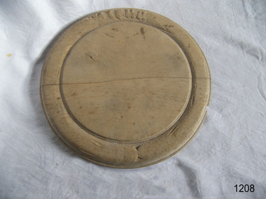
Domestic object - Bread Board
In the high tech, fast paced society that we live in, it’s easy to take some things for granted. Case in point: the wood cutting board on which you’ll probably be preparing the evening’s dinner. Have you ever taken the time to think about the history of the cutting board? Where did it come from, and what did ancient civilizations use to cut their meats, fruits and vegetables? Wood throughout the ages Since the dawn of time, wood has been one of the most available materials used by mankind to build tools and lodgings, so it’s not really surprising to know that wood has been used in the preparation of food since the prehistoric ages. Of course, back then, cavemen probably used an unpolished slab of tree trunk to cut the kill of the day on and they probably didn’t think twice about saving it once the meal was over. Chances are they probably threw it in the fire with the rest of the wood needed to kindle it. Advances in technology Throughout the centuries, mankind evolved and started creating machines from steam, electricity and metal. When the circular saw was invented, nicer, cleaner slabs of wood were cut and used as cutting boards. Since soft wood was the most available type of wood at the time, it was the material of choice for to be used for cutting boards. Boards were made smaller since the slab of wood could now be cut to any desired size. Since they were made smaller, they were also used to eat off of and some people referred to them as trenchers. Trenchers were originally pieces of stale hard bread that were used as substitute plates. Wood trenchers quickly became the replacements of the eatable dinnerware. The butcher block: the cutting board’s larger cousin In the industrial ages, many industries rapidly developed, and the butchery industry followed this trend as well. Before the invention of the cutting board, butchers used tree rounds to carve their meat on. The rounds were often too soft and they rapidly became unsanitary. Hard maple wood butcher blocks were the preferred choice of the industry. They were made to be extremely thick and durable, so durable in fact, that a butcher could use the same block for almost his entire career. Cutting boards around the world As cutting boards began to be more and more used in kitchens around North America, the rest of the world crafted such boards from different materials. The East used thick bamboo as their material of choice. Despite its frail appearance, bamboo is quite strong and made durable cutting boards and butcher blocks. Europe used maple in the crafting of their cutting boards while Persia used flat pieces of polished wood in their kitchens. The world then saw cutting boards that were being made from other materials like plastic and they came in all shapes and sizes, but they always served the same purpose, to provide a household with a safe, clean surface on which to prepare meals for their friends and family members. https://www.woodcuttingboards.com/news/quick-history-of-the-cutting-board-47.aspxThe bread board is an example of kitchen equipment used during Victorian times and similar to those used today.Bread board wooden round with carved inner circle and carving an outer rim in old English lettering "Bread"None.flagstaff hill, warrnambool, shipwrecked-coast, flagstaff-hill, flagstaff-hill-maritime-museum, maritime-museum, shipwreck-coast, flagstaff-hill-maritime-village, chopping board, cooking, kitchen equipment -
 Flagstaff Hill Maritime Museum and Village
Tool - Awl, Mid to late 20th century
An Awl is used to make indentations in wood or other materials in order to ease the insertion of a nail or screw. The blade is placed across the fibers of the wood, cutting them when pressure is applied. The Awl is then twisted through 90 degrees which displaces the fibers creating a hole. This then gives a start to the nail or screw being inserted into the work piece. There is a difference between an Awl and a Bradawl, the Awl is a small hand-held tool with a sharpened point and a Bradawl is similar but is flattened at its tip to produce a sharp chisel edge.An everyday tool used in carpentry, the subject item at this time cannot be associated with an historical event, person or place, provenance is unknown, item assessed as believed to have been produced during the 20th century.Awl with wooden handle with brass ferrule & steel pointed shaftStamped on handle J McArthur (owner)flagstaff hill, warrnambool, flagstaff-hill, flagstaff-hill-maritime-museum, maritime-museum, shipwreck-coast, flagstaff-hill-maritime-village, awl, j mcarthur, carpenders tools, woodworking tools, nail starter -
 Flagstaff Hill Maritime Museum and Village
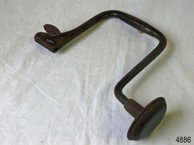
Tool - Brace & Bit, John S Fray, 1883 - 1906
Context: A brace is a hand tool used with a bit (drill bit or auger) to drill holes, usually in wood. The pressure is applied to the top and the tool is rotated with a U-shaped grip. Bits used to come in a variety of types but today the more commonly used Ridgeway and Irwin pattern bits also rely on a snail point (called the snail), which is a tapered screw point shaped the same as a wood screw thread, which helps to pull the bit into the wood as the user turns the brace handle and applies pressure. The designs used today come from an original idea and pattern invented by John S Fray. Company History: John S. Fray (1833 ) immigrated to Bridgeport Connecticut USA from England in the 1850s and established a working relationship with Nelson Spofford, who held an 1858 patent for a bit brace (the tool could be augured in a continuous circular motion by hand). He established the John S. Fray Co. around the same time and immediately began producing the Spofford bit brace. Fray himself held at least two patents: one awarded in 1869 for a boring brace attachment, and another awarded in 1883 for a tool handle. By 1889, the firm was located at the industrial complex that sits between the former International Silver Company and the former Bridgeport Chain Company on Crescent Avenue and is identified on the Sanborn Insurance Atlas as a manufacturer of Spofford bit braces, hollow handle awl, and toolsets. The company was in competition with Peck Stow and Wilcox Co. of Southington, and in 1898 was enjoined from making a ratchet bit brace for which the latter company held a patent. By the 1920s, the factory had been purchased by the Stanley Company of New Britain and leased to the American Tube and Stamping Company, a manufacturer of brass, copper, seamless, and bicycle tubing, which also ran a rolling mill to the south on Stafford Avenue (now demolished). The Stanley Company bought both mills in 1926, perhaps as a strategic move to be located along the Bridgeport Harbour, through which much of the raw material used in its operations throughout the state came. By the 1950s, the Crescent Avenue operations had been moved to other sites in Connecticut, and Stanley again leased the building to a company called Cornwall and Patterson, a manufacturer of piano hardware. Today the building appears to be vacant. An early carpenters tool made by a well known early manufacturer from America who instigated many innovations to the making of tools. His early pattern for the improvement of a tool that could be used for the boring of holes in wood was a significant step forward. His design for a boring brace attachment and later a specific handle is still in use today and his original brace and bit is now sought after by collectors of antique tools. Spofford Carpenter's Bit Brace metal has bit attached. Wing nut holds bit in place but nut missing. holds bit in place. 285mm long x 160mm Noneflagstaff hill, warrnambool, shipwrecked-coast, flagstaff-hill, flagstaff-hill-maritime-museum, maritime-museum, shipwreck-coast, flagstaff-hill-maritime-village -
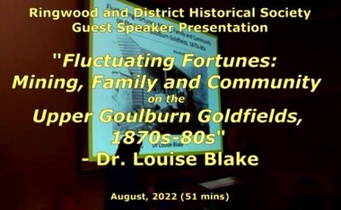 Ringwood and District Historical Society
Mixed media - Video, RDHS Guest Speaker Presentation - "Fluctuating Fortunes on the Upper Goulburn Goldfields 1870s-1880s" - Dr. Louise Blake
Digitised video (2.66GB) Duration: 51 minutes. Recorded August, 2022 (Video is available for viewing at Ringwood & District Historical Society Archives by appointment)Presenter: Louise Blake is a writer and historian with an interest in the stories of women, families, and communities on the nineteenth-century goldfields in Australia and New Zealand. Inspired by her family connection to the gold mining settlement of Woods Point, Louise completed a PhD on Women and Community on the Upper Goulburn Goldfields in north-east Victoria in 2019. In this talk Louise will share her research on Lawrence and Esther Chubb, who lived and worked at Gaffneys Creek on the Upper Goulburn Goldfields in the 1870s and 80s. In a series of letters Lawrence wrote to his family in England, and now held by the State Library of Victoria, Lawrence shared his early struggles as an independent miner on the central Victorian goldfields, his protracted courtship with Esther, the ordinary intimacies of their life at Gaffneys Creek, the work that Esther did to support the family in this remote mining region, as well as the material and emotional support provided by and to family, friends and neighbours. A rare and revealing source, these letters help to expand our understanding of the lived experience of mining families, particularly the work that women did to sustain families and communities, in this period of waged labour and tribute mining in Victoria. -
 City of Moorabbin Historical Society (Operating the Box Cottage Museum)
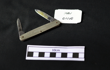
Tools, stainless steel pen-knife, 20thC
A penknife, or pen knife, is a small folding knife. It was originally used to describe a knife used for cutting or sharpening a quill to make a dip pen nib. Originally, penknives were used for thinning and pointing quills to prepare them for use as writing instruments and, later, for repairing or re-pointing the quills. They did not necessarily have folding blades, but resembled a scalpel or wood knife by having a short, fixed blade at the end of a long handle. Today a penknife can have single or multiple blades, and with additional tools incorporated into the design. The most famous example of a multi-function penknife is the Swiss Army knife A folding pen-knife with 2 stainless steel bladeson long blade end; STAINLESS / MADE IN / SHEFFIELDpen-knife, scouts, cheltenham, moorabbin, bentleigh, tools, early settlers -
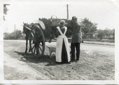 City of Moorabbin Historical Society (Operating the Box Cottage Museum)
Photograph - Photograph, Black & White Mrs J.L.Smith & Butcher, 1915
The Butcher Mr Bill Ellin delivering meat to Mrs J.L.Smith in front of the house Law Muir Den 510 Centre Rd Bentleigh c 1915. Groceries, Ice, Milk, Bread, Eggs, Poultry were delivered to housewives by the traders in horse drawn carts, Also Hawkers and Pedlars plied their wares by visiting the cottages. John Logan Smith 1860-1932 , the son of Irish immigrants James and Marianne Smith was born at their home near the 'Toll Gates' on Point Nepean Road and Dendy Street. East Brighton. At that time the area had many orchards that were later replaced by market gardens. J.L.Smith at first rented a cottage 'Law Muir Den' & Shed from Mr Box and commenced business as a wood merchant - sawing logs into shorter pieces using one horse to power the saw. He purchased the property, added to the buildings , began trading in fuel and fodder as well and installed a chaff cutting mill powered by 10hp steam engine. The business prospered 1909 following the death of Tommy Bent, J/L Smith was nominated for Councillor of the Shire of Moorabbin. WW1 1914 - 18 both John and Mary Ann supported local War Relief Auxiliaries and their son Vic served as a Signaler in AIF. As Motor transport was increasing 1926 J L Smith built a small Garage on the opposite corner (Woolworths Supermarket 2005) , employed a good mechanic ( Reg Hunt ) and developed another successful business. The Grain Store was managed by family until 1930. In 1932 JL Smith assisted a man whose car had broken down, pushing it to the garage and sadly suffered a heart attack and died. He is buried in Cheltenham Cemetery. J.L.Smith was an early settler in East Brighton now Bentleigh and established successful Wood cutting, Grain & Chaff cutting and Motor garage businesses in Centre Road . He was elected Councillor of the Shire of Moorabbin and, with Mary Ann, his family were involved with local Church, Red Cross, and other community organizations.A Black and white photograph c 1915 showing the Butcher delivering meat to Mrs J.L Smith Bentleighsmith j l, smith mary ann, stanley helen, smith vic, smith harry redvers, chaff cutter, horse drawn carts, toll gates brighton, motor cars 1900, steam engines, early settlers, bentleigh, parish of moorabbin, city of moorabbin, county of bourke, moorabbin roads board, shire of moorabbin, henry dendy's special survey 1841, bent thomas, charman s, highett william, ormond francis, market gardeners, vineyards, orchards, william ellin, butcher -
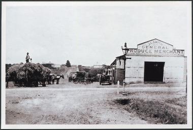 City of Moorabbin Historical Society (Operating the Box Cottage Museum)
Photograph, Black & White J. L. Smith Hay & Grain Store Bentleigh c1910, c1910
John Logan Smith 1860-1932 , the son of Irish immigrants James and Marianne Smith was born at their home near the 'Toll Gates' on Point Nepean Road and Dendy Street. East Brighton. At that time the area had many orchards that were later replaced by market gardens. J.L.Smith at first rented a cottage 'Law Muir Den' & Shed from Mr Box and commenced business as a wood merchant - sawing logs into shorter pieces using one horse to power the saw. He purchased the property, added to the buildings , began trading in fuel and fodder as well and installed a chaff cutting mill powered by 10hp steam engine. The business prospered 1909 following the death of Tommy Bent, J/L Smith was nominated for Councillor of the Shire of Moorabbin. WW1 1914 - 18 both John and Mary Ann supported local War Relief Auxiliaries and their son Vic served as a Signaler in AIF. As Motor transport was increasing 1926 J L Smith built a small Garage on the opposite corner (Woolworths Supermarket 2005) , employed a good mechanic ( Reg Hunt ) and developed another successful business. The Grain Store was managed by family until 1930. In 1932 JL Smith assisted a man whose car had broken down, pushing it to the garage and sadly suffered a heart attack and died. He is buried in Cheltenham Cemetery. J.L.Smith was an early settler in East Brighton now Bentleigh and established successful Wood cutting, Grain & Chaff cutting and Motor garage businesses in Centre Road . He was elected Councillor of the Shire of Moorabbin and, with Mary Ann, his family were involved with local Church, Red Cross, and other community organizations.Black & white photograph of the Hay & Grain Store of John Logan Smith 1860-1932 on the corner of Jasper Rd and Centre Rd Bentleigh ( East Brighton) c1910. A Horse drawn cart loaded with hay and another outside the first building used by J L Smith -
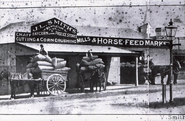 City of Moorabbin Historical Society (Operating the Box Cottage Museum)
Photograph, Black & White, J.L.Smith Hay & Grain Store c1916 Bentleigh, 1916
John Logan Smith 1860-1932 , the son of Irish immigrants James and Marianne Smith was born at their home near the 'Toll Gates' on Point Nepean Road and Dendy Street. East Brighton. At that time the area had many orchards that were later replaced by market gardens. J.L.Smith at first rented a cottage 'Law Muir Den' & Shed from Mr Box and commenced business as a wood merchant - sawing logs into shorter pieces using one horse to power the saw. He purchased the property, added to the buildings , began trading in fuel and fodder as well and installed a chaff cutting mill powered by 10hp steam engine. The business prospered 1909 following the death of Tommy Bent, J/L Smith was nominated for Councillor of the Shire of Moorabbin. WW1 1914 - 18 both John and Mary Ann supported local War Relief Auxiliaries and their son Vic served as a Signaler in AIF. As Motor transport was increasing 1926 J L Smith built a small Garage on the opposite corner (Woolworths Supermarket 2005) , employed a good mechanic ( Reg Hunt ) and developed another successful business. The Grain Store was managed by family until 1930. In 1932 JL Smith assisted a man whose car had broken down, pushing it to the garage and sadly suffered a heart attack and died. He is buried in Cheltenham Cemetery J.L.Smith was an early settler in East Brighton now Bentleigh and established successful Wood cutting, Grain & Chaff cutting and Motor garage businesses in Centre Road . He was elected Councillor of the Shire of Moorabbin and, with Mary Ann, his family were involved with local Church, Red Cross, and other community organizations.Black & White photograph of J L Smith Hay & Grain Store and Crushing Mill Jasper Rd / Centre Rd Bentleigh 1916. A veranda has been added to the store, new signage attached and a Gas light and hitching post are in foreground. 3 Horse drawn carts loaded with grain bags and drivers sitting on top of loadV. Smithgas street light, hitching posts, smith vic, photography, smith j l; smith mary ann, stanley helen, smith vic, smith harry redvers, chaff cutter, horse drawn carts, toll gates brighton, motor cars 1900, steam engines, early settlers, bentleigh, parish of moorabbin, city of moorabbin, county of bourke, moorabbin roads board, shire of moorabbin, henry dendy's special survey 1841, were j.b.; bent thomas, o'shannassy john, king richard, charman s, highett william, ormond francis, maynard dennis, market gardeners, vineyards, orchards -
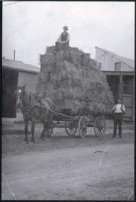 City of Moorabbin Historical Society (Operating the Box Cottage Museum)
Photographs, x 2 ,Black & White, F Smith Horse drawn cart loaded, Baled Straw, Grain, c1920
John Logan Smith 1860-1932 , the son of Irish immigrants James and Marianne Smith was born at their home near the 'Toll Gates' on Point Nepean Road and Dendy Street. East Brighton. At that time the area had many orchards that were later replaced by market gardens. J.L.Smith at first rented a cottage 'Law Muir Den' & Shed from Mr Box and commenced business as a wood merchant - sawing logs into shorter pieces using one horse to power the saw. He purchased the property, added to the buildings , began trading in fuel and fodder as well and installed a chaff cutting mill powered by 10hp steam engine. The business prospered 1909 following the death of Tommy Bent, J/L Smith was nominated for Councillor of the Shire of Moorabbin. WW1 1914 - 18 both John and Mary Ann supported local War Relief Auxiliaries and their son Vic served as a Signaler in AIF. As Motor transport was increasing 1926 J L Smith built a small Garage on the opposite corner (Woolworths Supermarket 2005) , employed a good mechanic ( Reg Hunt ) and developed another successful business. The Grain Store was managed by family until 1930. In 1932 J L Smith assisted a man whose car had broken down, pushing it to the garage and sadly suffered a heart attack and died. He is buried in Cheltenham Cemetery. J.L.Smith was an early settler in East Brighton now Bentleigh and established successful Wood cutting, Grain & Chaff cutting and Motor garage businesses in Centre Road . He was elected Councillor of the Shire of Moorabbin and, with Mary Ann, his family were involved with local Church, Red Cross, and other community organizations.2 x Black & White photographs showing horse drawn carts loaded with (a) Hay and (b) bags of grain outside J.L.Smith Grain & Chaff Store Centre Rd Bentleigh c1920smith frank, smith arch, smith tom, smith j l; smith mary ann, stanley helen, smith vic, smith harry redvers, chaff cutter, horse drawn carts, toll gates brighton, motor cars 1900, steam engines, early settlers, bentleigh, parish of moorabbin, city of moorabbin, county of bourke, moorabbin roads board, shire of moorabbin, henry dendy's special survey 1841, were j.b.; bent thomas, o'shannassy john, king richard, charman s, highett william, ormond francis, maynard dennis, market gardeners, vineyards, orchards -
 Anglesea and District Historical Society
Items from ship "Joseph H. Scammell"
1. Piano key from the wreck of the "Scammell". 2. Shavings of hull timber from the "Scammell" and few pieces of plywood contained in glass jar. 3. Shavings of hull timber from the "Scammell" plus small block of wood in large glass jar.1. "Key from piano of wrecked 'Scammell' / Point Danger Torquay 1891". 2. "From the wreck of the Joseph H. Scammell / May 8 1891 Torquay". Written in pen on both sides of key.joseph h. scammell, piano key -
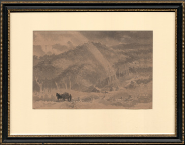 Latrobe Regional Gallery
Drawing, CURTIS, J. W, Matlock, Woods Point
Collection of Latrobe Regional GalleryCURTIS, J.W. Born England 1839 Died Australia 1901Signed l.r., ink "JCW". Not datedlandscape with horse and cart -
Whitehorse Historical Society Inc.
Article, Pioneers pass, 1926
... As a teenager he was engaged clearing a road to Woods.... As a teenager he was engaged clearing a road to Woods Point goldfields... clearing a road to Woods Point goldfields. He was manager for Theo ...Obituary for Mr H.H. Hatfield, well known orchardist.Obituary for Mr H.H. Hatfield, well known orchardist. As a teenager he was engaged clearing a road to Woods Point goldfields. He was manager for Theo. Kitchen 7 J.A. Kitchen at Pakenham and he interested them in the fruitgrowing industry. Several times he was president of the Central Fruitgrowers Association. In the early 1890s he started fruitgrowing on his own at Pakenham and later moved to Middleborough Road to live and start an orchard. He was president of Nunawading Shire 1917 -1918.Obituary for Mr H.H. Hatfield, well known orchardist. orchards, hatfield, h.h., central fruitgrowers association, kitchen, theo, kitchen, j.a., shire of nunawading