Showing 2288 items matching " parish."
-
 Glen Eira Historical Society
Document - St Mary The Virgin, Kooyong Road, South Caulfield
Parish of St Mary the Virgin, Flyer, calendar of church services and meeting from 24/02/1998 to 22/03/1998.st mary the virgin -
 Eltham District Historical Society Inc
Certificate - Certificate of Baptism, Nancy Josephine Pitt Withers, 27 October, 1902
Born 5 February 1902, son of Walter Herbert and Fanny Withers of Heidelberg, baptised in the Parish of St John, Heidelberg, Victoriabaptism certificate, fanny withers (nee flinn), john withers collection, walter herbert withers, 1902, charles meynell pitt withers, st john's anglican church heidelberg -
 Greensborough Historical Society
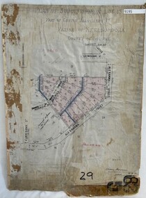
Poster - Planning Document, City of Heidelberg, Subdivision Plan # G 29 Part 1, Crown allotment 17, Greensborough, 1922
Plan of Subdivisions in City of Heidelberg: Parish of Keelbundoora: Crown allotment 17 - Warwick Road, Clydbank Street, Alexandra Street, 1922.An example of hard copy subdivision plans from the Greensborough area. Mainly from the Shire of Diamond Valley era (1964-1994).Plan (single sided) mounted on heavy card. Stamped and handwritten Council permissions, dates and other details.subdivision plans, city of heidelberg -
 Linton and District Historical Society Inc
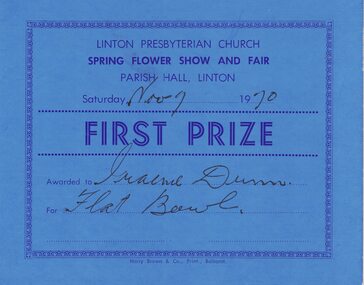
Certificate, Harry Brown & Co. Print., Ballarat, Linton Presbyterian Church Spring Flower Show, First Prize, 1970, 1970
Awarded to Graeme Dunn.Rectangular, blue cardboard certificate for first prize at Linton Presbyterian Church Spring flower show and fair, 1970.Text: " LINTON PRESBYTERIAN CHURCH / SPRING FLOWER SHOW AND FAIR / PARISH HALL, LINTON / Saturday Nov 7 1970 / FIRST PRIZE / Awarded to Graeme Dunn / For Flat Bowl.linton presbyterian church, events, flower shows, certificates, awards, graeme dunn -
 Linton and District Historical Society Inc
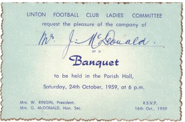
Invitation, Linton Football Club Ladies' Committee Banquet, 1959, 1959
Blue card, gold edging, dark blue writing. Invitation to Mr. J. McDonald to attend the Linton Football Club Ladies Committee banquet, held on 24th October 1959.Text: " LINTON FOOTBALL CLUB LADIES' COMMITTEE / request the pleasure of the company of Mr. J. McDonald / at a / Banquet / to be held in the Parish Hall, / Saturday, 24th October, 1959, at 6 p.m. "linton football club ladies' committee, mr j. mcdonald, mrs w. ringin, mrs g. mcdonald, events, invitations, tickets -
 Ringwood and District Historical Society
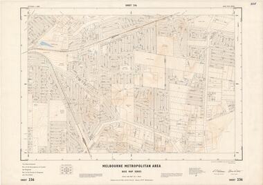
Map - Melbourne Metropolitan Area Base Map Series, Sheet 236 - Ringwood area, 1961
Map prepared by Dept of Lands and Survey and MMBW from State Aerial Survey June 1957 and Cadastral Survey information May 1961. This sheet comprises parts of the Municipalities of Croydon and Ringwood, and Parishes of Ringwood and Warrandyte.Scale: 400 feet to 1 inch. Contours at 5 feet vertical interval. By Authority: A.C. Brooks, Commonwealth Printer, Melbourne. -
Bendigo Historical Society Inc.
Map - CAMPBELL COLLECTION: BENDIGO & DISTRICT MAPS, 16-5-29
Map. Egerton, Parishes of Egerton and Whirrakee, scale 20 chains to 1 inch. Total area 5401 acres. Prepared in W.P.B. from A. and C.L. Plans by W.J. Galbraith (number 376 in map cupboard 1)W.J.Galbraithmap, bendigo, agricultural lands -
Bendigo Historical Society Inc.
Map - CAMPBELL COLLECTION: BENDIGO & DISTRICT MAPS, 5-4-28
Map. Sedgwick, Parishes of Strathfieldsaye, Lyell and Sedgwick. Scale 20 chains to 1 inch.Total area 5372 acres. Prepared in W.P.B. from C.l. and A. Plans by W.J. Galbraith. (number 374 in map cupboard 1)W.J.Galbraithmap, bendigo, agricultural lands -
Bendigo Historical Society Inc.
Map - CAMPBELL COLLECTION: BENDIGO AND DISTRICT MAPS
Map. Mandurang, Parish of Mandurang, Scale 20 chains to 1 inch. Total area 5993 acres, Northern Railway to left of map, Water Reserve (Spring Gully). (number 363 in map cupboard 1)map, bendigo, allotments -
Bendigo Historical Society Inc.
Map - CAMPBELL COLLECTION: BENDIGO AND DISTRICT MAPS
Map. Lockwood, Parishes of Lockwood and Shelbourne, scale 20 chains to 1 inch. Spring Creek centre of map and Bullock Creek to the right. Total area 4405 acres. (number 358 in map cupboard 1)map, bendigo, allotments -
 Bendigo Historical Society Inc.
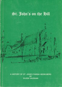
Book - ST JOHNS ON THE HILL, 1982
St Johns on the Hill, a history of St Johns parish Heidelberg, 144 pages with black and white photographs, inscription inside front cover reads, with best wishes to June a kindred spirit from Eileen Vaughan.Eileen Vaughanchurch, st johns heidelberg, st johns heidelberg, catholic church, religion. -
 Bendigo Historical Society Inc.
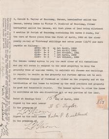
Document - EDWIN BUCKLAND COLLECTION: AGREEMENT BY HAROLD E. TAYLOR AND VICTOR P. BUCKLAND
Document. Agreement by Harold E. Taylor and Victor P. Buckland re leasing of land Allotment 3, Section 3 12 Parish of Goornong, Containing 301 acres 3 roods for the term of Three years. -
 Glenelg Shire Council Cultural Collection
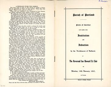
Document - Form of Service - Induction of the Rev. Ian Howard St. Clair into the Parish of Portland, at St. Stephen's Church of England 1957, Jan-57
Twelve page form of service to be used at the induction of the Rev. Ian Howard St. Clair into the Parish of Portland, at St. Stephen's Church of England, Monday, 14th Jan. 1957. White paper, black print, stapled.Front: 'B. Vivian' - handwritten, blue birost stephens church of england portland -
 Bendigo Historical Society Inc.
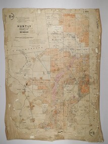
Map - HUNTLY, 16/11/1903
Map: Huntly, County of Bendigo. Parish plan. Drawn by Bartholomew Becket, examined by W S Stephen 15/3/80, examined by J Walshe Sept 1903, additions H Hansford August 1903map, bendigo, parish plan, bartholomew becket, w s stephen, j walshe, h hansford, huntly -
 Bendigo Historical Society Inc.
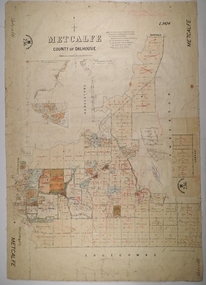
Map - METCALFE, 30/10/1878
Map: Metcalfe, County of Dalhousie. Parish plan (also has a smaller addition glued onto the right hand side) F. J. Vincent Draftsman Oct. 1876 Ex (unreadable signature) Oct 1878map, dalhousie, parish plan, metcalfe, f. j. vincent -
 University of Melbourne, Burnley Campus Archives
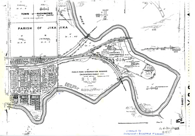
Plan, Allan & Tuxen et al, Public Park & Recreation Reserve (Richmond Park), 1886-1996
Shows changes in ownership of various parts of Richmond Park and Burnley Gardens including University of Melbourne, Amrad, Melbourne City Link, etc. from gazettal in 1873 to 1996Photocopy of plan of Richmond Park and Burnley Gardens with University of Melbourne land acquisition 13.10.1994 hand drawn on it, dates Act revoked and Gazette numbers. Based on plan of Parish of Jika Jika R 19 (3)"Changes to ownership & boundaries of Gardens" in inkpublic parks, recreation reserve, richmond, parish if jika jika, burnley gardens, horticultural society of victoria -
Glen Eira Historical Society
Pamphlet - St Margaret’s Church of England, Ripley Grove
Roneoed pamphlet printed for the inauguration of the Parish of St Margaret’s Caulfield and the induction of the venerable RHB Williams as it first vicar on 01/02/1961.st margaret’s church, caulfield, williams richard hazell brunton, choir, clergy residences, hall -
 Uniting Church Archives - Synod of Victoria
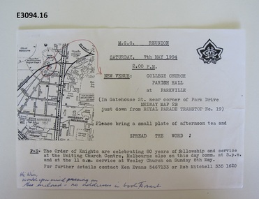
Document - Invitation, MGC Renunion
This in an invitation for a Methodist Girls' Comradeship reunion to be held on Saturday 27 May 1994 at 2 pm at College Church parish hall, Parkville. Single sheet of white paper with black typewritten text, MGC badge and map. There is a handwritten message in blue ink at the bottom."Hi Win, Would you mind passing on the enclused - no address in the book. Ta Barb"methodist girls' comradeship, methodist order of knights, college church parkville, ken evans, rob mtichell, win mountford, barbara harrison -
Hume City Civic Collection
Book, Led by the Spirit
This book was commissioned by the Parish of Our Lady of Mt. Carmel, Sunbury for a school reunion held in 2011. The main researcher on this book was Tracie Oldham.A green book with white writing and sketch of a church on front cover.Led by the Spiritchurches, our lady of mt carmel church, sunbury, local history, school reunion -
Glen Eira Historical Society
Document - St Aloysius Church, Caulfield
A photocopy of a document dated 26/05/1974 celebrating the fiftieth anniversary of the first Parish Mass in 1924 at St Aloysius Church Balaclava Road, Caulfield. The document lists the Catholic Priests and dignitaries who presided over the first Mass on 25/25/1924. A thanks to the past Parish priests from 1919 to 1974. Also included are three photocopies, of varying clarity, of a photograph of the front view of S1t Aloysius.st aloysius church, churches, festivals and celebrations, caulfield, architectural features, church services, parish of caulfield, architectural styles, balaclava road, clergy, people associated with religion, catholic church, bishops, mannix archbishop, daly t. rev fr., cooney h mr, o’ brien john a. rev. fr., o’ toole f. j. fr., hannan k fr., creed v. fr., kelly j. a bishop, knox cardinal. -
 City of Moorabbin Historical Society (Operating the Box Cottage Museum)
Booklet - Souvenir History of Centre Road, Bentleigh Methodist Church Centenary Celebrations. 9 May - 17 May 1953, 1953
Methodist Church, Centre Road. The first church building on the site was built of timber in 1850. In 1865, the wooden church building was sold and a new brick church was built, this building was expanded over the years to accomodate an ever increasing congregation. In 1928 the parish opened yet another new brick church - which still stands today (2022). The church is now the Greek Orthodox Parish of "Saints Raphael, Nicholas & Irene".The Methodist Church in Centre Road, Bentleigh was integral to the spiritual well being and social life of the early settlers.Photocopy of Booklet of 9 pages with text and pictures.early settlers, parish of moorabbin, city of moorabbin, county of bourke, shire of moorabbin, market gardeners, centre road, methodist sunday school, bentleigh, religion -
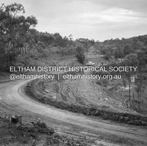
 Eltham District Historical Society Inc
Album - Photograph, J.A. McDonald, Kangaroo Ground-Queenstown Road, Mar. 1959
(Kangaroo Ground-St Andrews Road) Realignment South of Alma Road, Panton Hill Opposite CA Sec., Parish of Greensborough March 1959Record of various Shire of Eltham infrastructure works undertaken during the period of 1952-1962 involving bridge and road reconstruction projects, sometimes with Eltham Shire Council Project Reference numbers quoted. It was during this period that a number of significant improvements were made to roads and new bridges constructed within the shire that remain in place as of present day (2022). In many situations, the photos provide a tangible visible record of infrastructure that existed throughout the early days of the Shire. The album was put together by or under the direction of the Shire Engineer, J.A. McDonald.infrastructure, shire of eltham, bridge construction, heidelberg-kinglake road, road construction, 1959-03, alma road, kangaroo ground-queenstown road, kangaroo ground-st andrews road, panton hill -
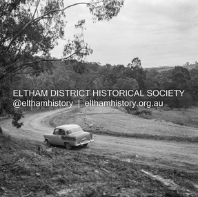
 Eltham District Historical Society Inc
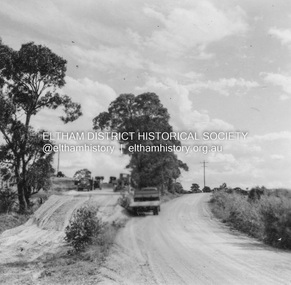
Negative - Photograph, J.A. McDonald, Heidelberg-Kinglake Road, Sep. 1960
Contractor Hillgrove Curve improvement south of St Andrews opposite CA 41 Sec. C, Parish of Greensborough October 1960 (probably September)Record of various Shire of Eltham infrastructure works undertaken during the period of 1952-1962 involving bridge and road reconstruction projects, sometimes with Eltham Shire Council Project Reference numbers quoted. It was during this period that a number of significant improvements were made to roads and new bridges constructed within the shire that remain in place as of present day (2022). In many situations, the photos provide a tangible visible record of infrastructure that existed throughout the early days of the Shire. The album was put together by or under the direction of the Shire Engineer, J.A. McDonald.infrastructure, shire of eltham, bridge construction, road construction, heidelberg-kinglake road, st andrews, 1960-09 -
 Eltham District Historical Society Inc
Negative - Photograph, J.A. McDonald, Heidelberg-Kinglake Road, Sep. 1960
Reconstruction September 1960 Looking south towards Ironbark Gully and showing deviation on right – opposite CA 37 Sec. C, Parish of GreensboroughRecord of various Shire of Eltham infrastructure works undertaken during the period of 1952-1962 involving bridge and road reconstruction projects, sometimes with Eltham Shire Council Project Reference numbers quoted. It was during this period that a number of significant improvements were made to roads and new bridges constructed within the shire that remain in place as of present day (2022). In many situations, the photos provide a tangible visible record of infrastructure that existed throughout the early days of the Shire. The album was put together by or under the direction of the Shire Engineer, J.A. McDonald.infrastructure, shire of eltham, bridge construction, road construction, heidelberg-kinglake road, st andrews, 1960-09 -
 Uniting Church Archives - Synod of Victoria
photograph, Undated
Wesley Morris was a Uniting Church lay reader in the Cann River and District Co-Operating Parish (Anglican - U.C.). Formerly with the Methodist church in Noorinbee.Colour photograph of Wesley Morris, Beryl Morris and Christine Morris standing in a church. -
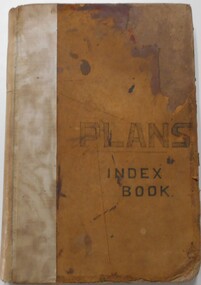 Bendigo Historical Society Inc.
Document - LANDS OFFICE, - INDEX TO CROWN LANDS SURVEYED AND SOLD IN THE DISTRICT OF SANDHURST
Document: Buff hard cover book, with fawn coloured binding on spine (later addition to mend spine?) On front cover drawn in black pen ' PLANS' and 'Index Book' On spine written in black ink ' plans index book'. Contains index of parishes in front of journal with 470 pages indexed to parishes. Double page entries: LH side page: town, suburban or country lands, total lands surveyed. Date of survey. RH page: allotment, section, particulars, no. page. Entries are not dated.Lands Officeland sales, lands office, land surveyed , land sold, bendigo, sandhurst -
 Bendigo Historical Society Inc.
Document - MARKS COLLECTION: PARISH PLAN OF WHITE HILLS
Sepia coloured map showing allotments in Parish of Sandhurst (White Hills) Written on LH side of map town and Suburban Lots White Hills Parish of Sandhurst. Scale is shown in chains. Surveyed by Horage Walker. Photo lithographed at the Department of Lands & Survey, Melbourne by J.Noone, Price 1/-. 6th. January 1865. Map shows Race Course Reserve at top of sheet, Municipal boundary is marked on LH side. Comments re vegetation throughout map. For example, poor soil timbered with Box scrub.on the back--Plan of Land White Hills Sandhurstbendigo, planning, white hills parish map, horage walker, j noone, department of lands and survey, -
Bendigo Historical Society Inc.
Map - CAMPBELL COLLECTION: BENDIGO AND DISTRICT MAPS
Map. Eaglehawk, Parishes of Huntly and Nerring. Scale 20 chains to 1 inch. Total area 6211 acres. Eaglehawk Kerang Railway, to Epsom 2 miles. Manure Depot. (number 390 in map cupboard 1)map, bendigo, allotments -
Bendigo Historical Society Inc.
Map - CAMPBELL COLLECTION: BENDIGO & DISTRICT MAPS, 14-6-29
Map. Eppalock, Sedgwick and Strathfieldsaye. Scale 20 chains to 1 inch. Total area 3972 acres. Prepared in W.P.B. from Assessment Plan and Parish Plans. H.A. Darby. (number 378 in map cupboard 1)H.A.Darbymap, bendigo, agricultural lands -
 Bendigo Historical Society Inc.
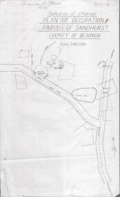
Photograph - DIAMOND HILL 1936, PLAN OF OCCUPATION
Print of 'Application of J. Hattam, plan of occupation parish of Sandhurst, County of Bendigo' Plan shows Post Office site, large dam, 'formerly cultivated site near Post Office'. A un-named gully is marked.bendigo, mining, diamond hill