Showing 3852 items
matching surveyed
-
 Bendigo Historical Society Inc.
Map - CAMPBELL COLLECTION: BENDIGO AND DISTRICT MAPS
Map. Marong, Parishes of Marong, Lockwood and Mandurang. Scale 20 chains to an inch. Total 5106 acres. Compiled in W.P.B. from Field Survey and Parish Plans. Crusoe Reservoir to the right of map. (number 362 in map cupboard 1)map, bendigo, parish plan -
Bendigo Historical Society Inc.
Book - DEPARTMENT OF MINES 1914 BULLETINS OF THE GEOLOGICAL SURVEY OF VICTORIA NO. 33. HUSTLER'S LINE OF REEF, BENDIGO, 1914
Department of Mines 1914 Bulletins of the Geological Survey of Victoria No. 33. Hustler's Line of Reef, Bendigo. Photos of the mines on the Hustler's Line of Reef. 59 pages plus 7 pages of photos. Inscribed A. Richardson 29 Harrison street, BendigoDepartment of Mines.bendigo, mining, hustler's line of reef, mining, and hustler's reef mines. -
Bendigo Historical Society Inc.
Map - ROCHESTER WEST : COUNTY OF BENDIGO, 30-10-12
Map. Rochester West, County of Bendigo, Ballendella, Giggorra, Township of Rochester. Campaspe River. Photo-lithographed at the Department of Lands and Survey, Melbourne, by W.J. Butson 30-10-12. Price 1/-. (number 22 in map cupboard 1)W.J. Butson, Government Printer.map, bendigo, rochester west -
 Bendigo Historical Society Inc.
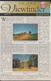
Newspaper - JACK PERRY COLLECTION: NEWSPAPER LIGHTNING HILL
Newspaper article, Bendigo Weekly, on Lightning Hill and Permanent Survey Markers, their importance in mapping, drainage and sewerage planning. Marker on Lightning Hill shows distance and direction to Mr. Ida Heathcote, Pyramid Hill, Mt. Moliagul and Mt. Korong.person, individual, jack perry, lightning hill, permanent survey markers, windmill hill -
Bendigo Historical Society Inc.
Map - YALLOOK : COUNTY OF BENDIGO, 1957
Map. Yallook, County of Bendigo,Talambe, Tandarra, Neilborough, Yarraberb, Salisbury, Pompapiel. Drawn and reproduced at the Department of Lands and Survey, Melbourne.1957. Price 2/-. By authority W.M. Houston, Government Printer. (number 11 in map cupboard 1)W.M Houston, Government Printermap, bendigo, yallook -
Bendigo Historical Society Inc.
Map - VICTORIA HILL AREA, May 1971
Map: Bendigo Historical Society feature plan. There are 3 of these plans, one is without feature names and one has several places highlighted in pencil. Compiled by AHQ Survey Regiment, CMF Increment ( number 181 in Map Cupboard 1)map, bendigo, mining plan, victoria hill, bendigo historical society -
 Villa Alba Museum
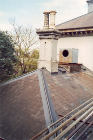
Photograph - Villa Alba roof, chimney & chimney pots, c.1987
Built for William and Anna-Maria Greenlaw in the early 1880s, and with interiors decorated by the Paterson Bros, Villa Alba remained in private ownership until 1949. From 1950, the house was owned by a number of institutions. By 1984, the Villa Alba Preservation Society had been formed, and three years later, the Mount Royal Hospital granted a 25-year lease to Kew Council. In 2004, the title to Villa Alba was passed by the Victorian Government to The Villa Alba Museum Incorporated. The Museum, at 44 Walmer Street, Kew, is now a cultural institution committed to the collection, study and display of 19th century interior decorative finishes, and the components of 19th and 20th century interior decoration.This is one of a number of historically and aesthetically significant photos of the interiors and exterior of Villa Alba when it was still owned by the Mount Royal Hospital, showing twentieth century accretions and deterioration of the historic fabric of the building. This was a benchmark survey against which future conservation and restoration activities can be measured.In December 1987, Mockridge Stahle & Mitchell Pty Ltd Architects prepared ‘Villa Alba Survey: A Report on the fabric for Mount Royal Hospital’ of which this photograph is a part. Photo of Villa Alba rear slate roof, chimney & chimney potsvilla alba museum, conservation photographs, victorian architecture, slate roofs -
 Villa Alba Museum
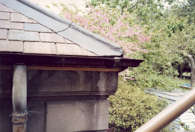
Photograph - Corner of slate roof with downpipes, c.1987
Built for William and Anna-Maria Greenlaw in the early 1880s, and with interiors decorated by the Paterson Bros, Villa Alba remained in private ownership until 1949. From 1950, the house was owned by a number of institutions. By 1984, the Villa Alba Preservation Society had been formed, and three years later, the Mount Royal Hospital granted a 25-year lease to Kew Council. In 2004, the title to Villa Alba was passed by the Victorian Government to The Villa Alba Museum Incorporated. The Museum, at 44 Walmer Street, Kew, is now a cultural institution committed to the collection, study and display of 19th century interior decorative finishes, and the components of 19th and 20th century interior decoration.This is one of a number of historically and aesthetically significant photos of the interiors and exterior of Villa Alba when it was still owned by the Mount Royal Hospital, showing twentieth century accretions and deterioration of the historic fabric of the building. This was a benchmark survey against which future conservation and restoration activities can be measured.In December 1987, Mockridge Stahle & Mitchell Pty Ltd Architects prepared ‘Villa Alba Survey: A Report on the fabric for Mount Royal Hospital’ of which this photograph is a part. Photo of exterior of Villa Alba showing corner of slate roof with downpipes.villa alba museum, conservation photographs, victorian architecture, etched glass, slate roofs, victorian downpipes -
 Villa Alba Museum
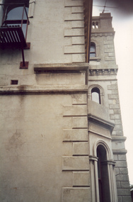
Photograph - Profile of bay window and tower, c.1987
Built for William and Anna-Maria Greenlaw in the early 1880s, and with interiors decorated by the Paterson Bros, Villa Alba remained in private ownership until 1949. From 1950, the house was owned by a number of institutions. By 1984, the Villa Alba Preservation Society had been formed, and three years later, the Mount Royal Hospital granted a 25-year lease to Kew Council. In 2004, the title to Villa Alba was passed by the Victorian Government to The Villa Alba Museum Incorporated. The Museum, at 44 Walmer Street, Kew, is now a cultural institution committed to the collection, study and display of 19th century interior decorative finishes, and the components of 19th and 20th century interior decoration.This is one of a number of historically and aesthetically significant photos of the interiors and exterior of Villa Alba when it was still owned by the Mount Royal Hospital, showing twentieth century accretions and deterioration of the historic fabric of the building. This was a benchmark survey against which future conservation and restoration activities can be measured.In December 1987, Mockridge Stahle & Mitchell Pty Ltd Architects prepared ‘Villa Alba Survey: A Report on the fabric for Mount Royal Hospital’ of which this photograph is a part. Photo of exterior of Villa Alba showing profile of bay window and tower.villa alba museum, conservation photographs, victorian architecture, cement render, quoins, bay windows, towers -
Whitehorse Historical Society Inc.
Map, Aerial Photographs Nunawading, 1970
State Aerial Survey, Melbourne 1970.State Aerial Survey, Melbourne 1970. Project runs 34 - 39 - City of Nunawading. Frames numbered from South to North boundaries, each strip numbered from East to West. See table of index and photo numbers attached.non-fictionState Aerial Survey, Melbourne 1970.state aerial survey, aerial photographs, nunawading, mitcham, blackburn, blackburn north, blackburn south, forest hill, vermont, burwood east, vermont south -
 Lakes Entrance Regional Historical Society (operating as Lakes Entrance History Centre & Museum)
Photograph, Lakes Post Newspaper, 1998
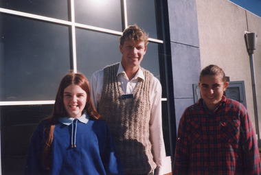
Colour photograph Secondary College students Emma Hyden and Rebecca Peterson with Tilo Junge, Waste Management Officer from East Gippsland Shire, at front of E G Shire offices, for Recycling Survey program. Lakes Entrance Victoriaschools -
University of Melbourne, Burnley Campus Archives
Plan, Alton-Hascombe Feature Survey, c. 1990
1 tracing paper and 2 paper copies, plan by Department of Conservation, Forests and Lands. Division of Survey and Mapping. Scale 1:1000. Plan of property includes buildings, gardens and paddocks. 1 copy has significant buildings coloured.alton-hascombe, survey -
University of Melbourne, Burnley Campus Archives
Plan, Plan of the Zoological and Acclimatisation Society of Victoria, Royal Park, Melbourne, c. 1884
Copy of plan held at the State Library of Victoria surveyed by G. Purchas, possibly 1884. Possibly based on the winning competition entry by Alfred Lynch 1861 (See B17.0076). Also see B18.0030 Plan drawn by Caroline Le Souef.caroline le souef, alfred lynch, zoological and acclimatisation society of victoria, royal park, g. purchas -
 Melbourne Tram Museum
Document - Report, Melbourne & Metropolitan Tramways Board (MMTB), "Survey of Passengers April 1974 - first Z3 tram in service", 25/09/1979 12:00:00 AM
Photocopy of an A4 page with hand written headings, titled "Survey of Passengers April 1974 - first Z3 tram in service", giving response to the questionnaire completed by 110 passengers and comments received. Signed R. Dunning? 25-9-1979.trams, tramways, z3 class, surveys, new trams -
 Melbourne Tram Museum
Document - Memorandum, Peter Spruch, Carolyn Cleak, "Result of PTC Uniform Survey", mid 1990's
Photocopy of a two single A4 sheets, titled "Result of PTC Uniform Survey", carried out by Driver Peter Spruch and Driver Carolyn Dean, mid 1990's?. Gives the view of the respondents of both male and females on the then current uniforms.trams, tramways, employees, uniforms, surveys -
 Bendigo Military Museum
Photograph - Bones Day - Army Survey Regiment Versus RAAF School of Radio, Laverton, c1970s
These seven photographs were taken at Bones Day, an annual sports competition between the Army Survey Regiment and the RAAF School of Radio c1970s. The two units took turns each year to host the event and on this occasion was held at the RAAF School of Radio, Laverton. The day competition usually comprised basketball, cross country, golf, sailing, squash, softball, tennis, touch football, rifle shooting, tug-of-war and volleyball. The “big bone” trophy comprising a large bone from a beast housed inside a wooden framed glass case, was awarded to the winner of the day competition. The evening competition often included darts, carpet bowls, hookey, quoits and billiards/snooker. The “little bone” (a mounted chicken bone) was the consolation trophy awarded to the winner of the evening competition. The 3-hour bus trip for the visiting unit on their return was typically very raucous. The history of the Bones Day competition is best described in the booklet titled - Bones of Contention Souvenir Program. 1965. Refer to Item 6267.These seven photographs were taken at Bones Day, an annual sports competition between the Army Survey Regiment and the RAAF School of Radio at Laverton, Victoria c1970s. The photographs are on 35mm negative film. They are part of the Army Survey Regiment’s Collection. The photographic negatives were scanned at 96 dpi. There are additional photos taken at the time that have not been scanned. .1) - Photo, black & white, c1970s, L to R: Unknown, Heather Slater and unidentified RAAF personnel. .2) & .3) - Photo, black & white, c1970s, Bill Friswell playing snooker. .4) & .5) - Photo, black & white, c1970s, Bus trip back to Bendigo. Gordon Lowery, unidentified personnel. .6) - Photo, black & white, c1970s, Bus trip back to Bendigo. L to R: Peter Tieman (asleep), Phil Batchelder (Batchelor?), background Bill Friswell (at rear), Steve Gloster, Gordon Lowery (standing), Graham Bradtke, Andy Covington, Greg Towne, TJ Wicker, Roger Pearson (asleep), unidentified personnel. .7) - Photo, black & white, c1970s, Bus trip back to Bendigo. L to R: Peter Tieman (asleep), Phil Batchelder (Batchelor?), background Bill Friswell (at rear), Gordon Lowery (standing), Graham Bradtke, Greg Towne, TJ Wicker, Roger Pearson (asleep), unidentified personnel.1P to .7P – No personnel are identified.royal australian survey corps, army svy regt, rasvy, army survey regiment, raaf school of radio, asr, bones day -
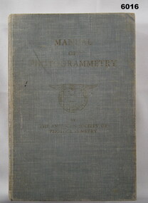 Bendigo Military Museum
Manual - Manual of Photogrammetry, (Preliminary Edition), 1934 American Society of Photogrammetry, Circa 1934
This book belonged to Brigadier FD Buckland OBE Director of Survey Land HeadquarterHardcover, light blue, 819 pages, text, diagrams, photographsroyal australian survey corps, rasvy, fortuna, army survey regiment, army svy regt, asr, photogrammetry -
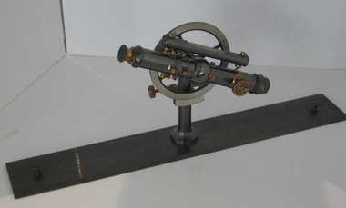 Federation University Historical Collection
Instrument - Surveyor's Instrument, Boxed Theodolite, c late 1880s
According to Max Clarke this item was used by the surveying classes at the Ballarat School of MinesA boxed (timber) theodolite with crossbars and full-length stadia wires. The theodolite can be mounted on a metal straightedge base. The box also contains a magnetic compass with two bubble levels, a plumbing folk, and 4 brass paper clips designed to suit a plan table. On box in black paint "A 1". Inside box lid is manufacturer's label and Stadia measurement zero reference calibration.ballarat school of mines, surveying equipment, gurley, max clarke, theodolite, stadia measurement, calibration, scientific instrument -
Federation University Historical Collection
Book, Jacobs Lewis Vines Architects and Conservation Planners, Historic Sites Survey: Ballarat Study Area, 1980, 1980
This survey was commissioned by the Land Conservation Council, Australian Heritage Commission and the Ministry for Conservation 114 page report on historic sites in the Ballarat region. It includes information on sites, a schexdule of sites, silte selection and designated areas (ie around towns)historic sites, ballarat, wendy jacobs, miles lewis, gary vines, berringa, buninyong, creswick, dunnstown, fiery creek, lal lal, langi logan, cathcart, mount cole, mount egerton, nerrina, gong gong, wombat state forest, railways, explorers routes, early roads, land conservation council, ausralian hertiage commission, department of planning, icomos (burra) charter, nigel lewis, richard aitken, freehold land, public land, langi ghiran, new jubille mine, birthday tunnel mine, pitfield plains, smythesdale, buninyong company, mount clear, mt clear, canadian gully, warrenheip distillery, thomas mitchell, waterloo, trawalla, beaufort, raglan, internment camps, forestry, mining, mining, mt egerton, mary hollick collection, jubilee mine, burra charter, historica areas data form, explorers, egerton company, black horse mine, mt egerton government battery, kaolin mines, anderson brothers, barkstead, anderson's tramway, clarkesdale, berry leads, birthday tunnel mine berringa, warrenheip, australasian company, mount mercer, lanvi-kal-kal, water race -
Moorabbin Air Museum
Document (Item) - Field Service Surveys Sabre 544
Description: Field Service Surveys (Defect Reports) Sabre 540 Level of Importance: . -
Moorabbin Air Museum
Document (Item) - Field Service Surveys Sabre 545
Description: Field Service Surveys (Defect Reports) Sabre 544 Level of Importance: . -
Moorabbin Air Museum
Archive (Item) - Flight Test Reports Sabre 944-950
Description: Field Service Surveys (Defect Reports) Sabre 545 Level of Importance: . TIDS -
Moorabbin Air Museum
Document (Item) - Mirage Wing Sets - Pre Installation Tested - Serial Nos 1-111 Inspection Cards
Description: Field Service Surveys (Defect Reports) Sabre 580 Level of Importance: . -
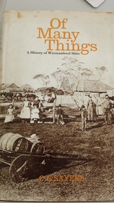 Peterborough History Group
Book, C.E.Sayers, Of Many Things, 1972
Book contains information about early Peterborough: survey and settlers, schools and wrecks.Provides insight into the early formation of the township of Peterborough and its terrain.Hardcover 188 page book with indexInscription "donated by Barry Jenkins"peterborough history, irvine family, peterborough school, shipwrecks, shipwreck coast, great ocean road, warrnambool, peterborough shipwreck -
 Ballarat Heritage Services
digital copy, Surveyor's Notebook Ballarat East, 24 August 1858
Survey of land in Ballarat East in August 1858 showing hotels and tents etc. Images from Bellair's surveyor's book.eugene bellair, surveying, surveyor, eureka stockade -
 Bendigo Military Museum
Photograph - Army Survey Regiment Group Photos, Fortuna Villa, Bendigo, 1990
This is a set of 11 photographs of personnel posted to the Army Survey Regiment in 1990. These formal group photos of three of the four Squadrons, Officers, and Warrant Officers/Sergeants were probably taken after CO’s Parades. Although photo .11P is part of this set of negatives, it was taken on another occasion as the SGTs Mess personnel were in summer uniforms. Photos of Lithographic Squadron from this set of negatives are catalogued in item 6441.15P. LTCOL John Winzar was the CO of the Army Survey Regiment from 1987 to 1989 and WO1 Neville Stone was the RSM from 1988 to 1990.This is a set of 11 photographs of personnel posted to the Army Survey Regiment, Fortuna Villa, Bendigo Victoria on the 1st of October 1990. The photographs are on 35mm negative film and were scanned at 96 dpi. They are part of the Army Survey Regiment’s Collection. .1) to .2) - Photo, black & white, 1990. Senior appointments: L to R: RSM WO1 Neville Stone, CO LTCOL Rene van den Tol, 2IC MAJ Duncan Burns, ADJT CAPT Peter Parkes. .3) - Photo, black & white, 1990. Officers Mess: Back row L to R: back row L to R: LT Craig Hersant, LT Greg Tolcher, LT Martin Lyons, LT Steve Hledik, LT Derek Bell, LT Simon Buckpitt. Centre row L to R: CAPT Roger Greenwell, CAPT Dave McLachlan, ADJT CAPT Peter Parkes, unidentified UK exchange officer, CAPT Noel ‘Nesty’ Coulthard. Front row L to R: CAPT John South, MAJ Bob Coote, MAJ Neil Taylor, CO LTCOL Rene van den Tol, 2IC MAJ Duncan Burns, MAJ Peter Clark, MAJ Ray Redman. .4) - Photo, black & white, 1990. SGTs Mess: Back row L to R: SGT Max Watson, unidentified, SGT Martin Evans, SSGT Graham Johnston, SGT Brian Fauth, SGT Ian Fitzgerald, unidentified, SGT Mick Minchin, SGT Kim Reynolds, SGT Peter Imeson, SGT Brian Paul, SSGT John Phillips, SGT Keith Quinton, unidentified (x2), SSGT Noel McNamara, SGT Paul Hopes, SGT Brendan McKinless. 3rd row L to R: SSGT Di Chalmers, SGT Bob Bright, SGT Doug Carswell, WO2 Steve Egan, unidentified, SSGT Garry Drummond, SGT Steve Burke, SSGT Russ Mollenhauer, SGT Paul Cheater, SGT Sandy Craig, SSGT Peter Mustart, SGT Roger Rees, SGT Paul Leskovec CSM, unidentified, SGT John Shephard, SGT Frank Downie, SSGT Bruce Hammond, unidentified. 2nd row L to R: WO2 Jeff Willey, WO2 Barry Lutwyche OAM, WO2 Rob Bogumil, WO2 Rhys De Laine, WO2 Ted Burgess, WO2 Wayne Rothwell, WO2 Steve Hansen, WO2 Keith Fenton RE UK Exchange, SGT Chris Edwards, SGT Russ Mollenhauer, unidentified, SGT Greg Else, unidentified, SSGT Bob Garritty, SSGT Greg Byers, WO2 Pat Lumsden, WO2 George Graham, WO2 Mick Hogan, SGT Sherri (Dally) Burke. Front row L to R: WO1 Trevor Osborne, WO1 Colin Cuskelly, WO1 Bob Rogister, WO1 Allan Hancox, WO1 Bill Jones, 2IC MAJ Duncan Burns, RSM WO1 Neville Stone, WO2 Neil ‘Ned’ Kelly, WO1 Ken Slater, WO1 Rowan Gillies, WO1 Graham Ragless, WO1 Gary Warnest, WO2 Adrian ‘Charlie’ Creedy. .5) - Photo, black & white, 1990. Air Survey Squadron: Back row L to R: SPR Mark Linwood, SPR Trevor Roddam, CPL Noel Brinsmead, CPL Mark Lander, SGT Frank Downie, CPL Sandy Craig. 3rd row L to R: SPR Steve Rundle, SPR Cameron Gee, CPL Darren Wilkinson, CPL Dave Longbottom, CPL Max Watson, SPR Shane Torrens, SGT Paul Hopes, SPR Chris Woodman. 2nd row L to R: SGT John Shephard, SPR Paul Boulton, SPR Stuart Bowd, SPR Paula (Golding) Brinsmead, SPR Joanne Otto, CPL Steve Coulson, SPR Steve Linane, CPL Chris ‘Charlie’ Brown. Front row L to R: SSGT Bruce Hammond, WO2 Barry Lutwyche OAM, LT Craig Hersant, WO1 Allan Hancox, MAJ Peter Clark, LT Simon Buckpitt, WO2 Neil ‘Ned’ Kelly, SSGT SSGT Noel McNamara. .6) - Photo, black & white, 1990. Headquarters Squadron: Back row L to R: unidentified (x2), SPR Wolfgang Hofbauer, SGT Chris Edwards, CPL Pat Drury, SSGT John Phillips, unidentified, CPL Graeme Priestley, unidentified (x2), SGT Paul Leskovec CSM, LCPL Richard Arman. 4th row L to R: unidentified, SGT Ian Fitzgerald, unidentified (x2), LCPL Bob Sheppard, unidentified (x2), CPL John ‘Flash’ Anderson, SPR Todd Reynolds, SGT Keith Quinton, CPL Roger Pearson, unidentified, WO1 Bob Rogister. 3rd row L to R: WO2 Wayne Rothwell, SSGT Peter Mustart, SPR Eric Nicholson, unidentified, SGT Paul Cheater, unidentified, SGT Wolfgang Thun, unidentified (x2), CPL Paul Richards, SGT Mick Minchin, unidentified. 2nd row L to R: unidentified, SPR Kasey Northausen, unidentified, CPL Michelle Griffith, unidentified (x3), SPR Tracy Tillman, unidentified (x4), WO2 Steve Hansen. Front row L to R: WO1 Rowan Gillies, WO1 Colin Cuskelly, CAPT Noel ‘Nesty’ Coulthard, CAPT Roger Hancock, WO1 Ken Slater, MAJ Ray Redman, MAJ John South, unidentified UK exchange officer, WO2 Ted Burgess, WO2 George Graham, unidentified civilian. .7) & .8) - Photo, black & white, 1990. Cartographic Squadron: Back row L to R: Back row L to R: SGT Greg Else, CPL Perry Burt, SSGT Graham Johnston, CPL Mick McConnell, 3rd row L to R: SGT Bob Bright, SGT Doug Carswell, SPR Marcus Seecamp, CPL John Gilbert. 2nd row L to R: SGT Martin Evans, SPR Sandy Winn, SPR Jeanette Drury-Lane, SPR Simone Rodgers, Front row L to R: SPR Guenther Ebenwaldner, WO2 Pat Lumsden, LT Steve Hledik. .9) - Photo, black & white, 1990. Cartographic Squadron: Back row L to R: SGT Greg Else, CPL Perry Burt, SSGT Graham Johnston, CPL Mick McConnell, unidentified, SPR Mark Linwood, SPR Lee Palfrey, SPR John ‘Doc’ Commons, SPR Chris Wynn, SPR Mick Duggan, CPL Peter Johnson, SPR Allan Blake, CPL Damian Killeen, SPR Grant Davis, SPR Simon Reynolds, SPR Peter Smyth. 3rd row L to R: SPR Guenther Ebenwaldner, SGT Bob Bright, SGT Doug Carswell, SPR Marcus Seecamp, CPL John Gilbert, SPR Gordon Santo, SPR Frank Savy, SPR Chris Woodman, SSGT Greg Byers, SPR David Lankshear, SSGT Bob Garritty, CPL Craig Kellet, CPL Darren Maher, CPL Barry Hogan, CPL Dan Cirsky, SPR Bob Bousfield. 2nd row L to R: SGT Martin Evans, CPL John Reid, SPR Sandy Winn, SPR Jeanette Drury-Lane, SPR Simone Rodgers, SPR Cam Bramich, SPR Ailsa (Sorby) Miller, SPR Nadine (Paul) Read, SPR Jodi Seath, SGT Sherri (Dally) Burke, SPR Di (Thomas) Soutar, SPR Dawn Hoadley, CPL Raelene (Munting) Brodie, SPR Jo (Innes) Thun? SPR Damian Nolan. Front row L to R: WO2 Pat Lumsden, LT Steve Hledik, LT Derek Bell, CAPT Dave McLachlan, MAJ Neil Taylor, WO1 Graham Raglass, WO1 Gary Warnest, WO2 Mick Hogan, WO2 Adrian ‘Charlie’ Creedy. .10) - Photo, black & white, 1990. Cartographic Squadron leadership: Back row L to R: CAPT Dave McLachlan, LT Derek Bell, LT Steve Hledik, WO2 Pat Lumsden, WO2 Mick Hogan, WO2 Adrian ‘Charlie’ Creedy. WO1 Gary Warnest. Front row L to R: MAJ Neil Taylor, WO1 Graham Raglass. .11) - Photo, black & white, 1990. SGTs Mess: Back row L to R: WO2 Jeff Willey, unidentified, SGT Brian Fauth, unidentified, SGT Sandy Craig, unidentified, SGT Paul Leskovec CSM, SSGT John Phillips, unidentified, SGT Martin Evans, SGT Steve Burke, SGT Brendan McKinless, SGT Chris Edwards. 3rd row L to R: SGT Brian Paul, unidentified, SSGT Bob Garritty, SSGT Greg Byers, SGT Kim Reynolds, SGT John Reid, unidentified, SSGT Rick van der Bom, SGT Dale Hudson, unidentified, SGT John ‘Stormy’ Tempest, SGT Keith Quinton, SGT Greg Else. 2nd row L to R: WO2 Rob Bogumil, unidentified, WO2 Adrian ‘Charlie’ Creedy, WO2 George Graham, WO2 Wayne Rothwell, WO2 Pat Lumsden, WO2 Mick Flynn, WO2 Ted Burgess, unidentified, SSGT Dennis Learmonth, SGT Bob Bright, WO2 Steve Hansen, WO2 Rhys De Laine. Front row L to R: unidentified, WO1 Trevor Osborne, WO1 Bill Jones, WO1 Colin Cuskelly, MAJ Ray Redman, RSM WO1 Neville Stone, WO1 Stu Thaxter, WO2 Mick Hogan, WO1 Bob Rogister, WO1 Ken Slater, WO1 Gary Warnest..1P to .11P – no annotationsroyal australian survey corps, rasvy, army survey regiment, army svy regt, fortuna, asr -
 Bendigo Military Museum
Photograph - Lithographic Squadron Regimental Training, Army Survey Regiment, Bendigo, 1989
This is a set of 24 photographs of Army Survey Regiment’s Lithographic Squadron personnel undertaking regimental training in an unknown location in April 1989. The purpose of the training was probably to provide personnel a practical knowledge of navigation and map reading, RATEL and Survival in the Field, vehicle camouflage, teamwork and leadership. The training did not include infantry and minor tactics due to the absence of weapons. Although these photos are not annotated other than the month and year, most personnel are positively identified.This is a set of 24 photographs of personnel from Lithographic Squadron, Army Survey Regiment, Fortuna, Bendigo, undergoing regimental training in April 1989. The photographs were on 35mm negative film and scanned at 96 dpi. They are part of the Army Survey Regiment’s Collection. .1) - Photo, black & white, 1989, background L to R: Frank Lenane, Bill Jones, foreground L to R: Gavin McLean, Colin Yeats, Peter Dillon. .2) - Photo, black & white, 1989, Rhys De Laine. .3) - Photo, black & white, 1989, L to R: Peter Breukel, Colin Yeats. .4) - Photo, black & white, 1989, L to R: Colin Yeats., Peter Dillon. .5) - Photo, black & white, 1989, L to R: Graeme Spong, Gavin McLean, unidentified (x2), Peter Breukel, Steve Burke, Bill Jones, Colin Yeats. .6) - Photo, black & white, 1989, L to R: Graeme Spong, Bill Jones, Colin Yeats, Peter Dillon, Peter Breukel, Steve Burke, Colin Yeats. .7) - Photo, black & white, 1989, L to R: Graeme Spong, Bill Jones, Colin Yeats, Peter Dillon, .8) - Photo, black & white, 1989, Colin Yeats. .9) - Photo, black & white, 1989, L to R: Gavin McLean, Colin Yeats. .10) - Photo, black & white, 1989, L to R: Steve Burke, Peter Breukel, Colin Yeats, unidentified. .11) - Photo, black & white, 1989, L to R: Steve Burke, Peter Breukel. .12) - Photo, black & white, 1989, L to R: Peter Breukel, Steve Burke. .13) - Photo, black & white, 1989, Craig Hersant. .14) - Photo, black & white, 1989, L to R: Rob Bogumil, Darren Maher, Paul Baker, Rob Jones, Shona Hastie, unidentified, Chad Hardwick. .15) - Photo, black & white, 1989, L to R: Chad Hardwick, unidentified, Rob Bogumil, Rob Jones, Darren Maher, unidentified, Paul Baker. .16) - Photo, black & white, 1989, L to R: Rob Bogumil, Darren Maher, Chad Hardwick, Rob Jones, unidentified (x2), Paul Baker. .17) to .22) - Photo, black & white, 1989, unidentified personnel applying camouflage to truck. Shona Hastie in truck, .23) - Photo, black & white, 1989, L to R: LT Dave Weston, LT Craig Hersant, Trevor Osborne, Bill Jones. .24) - Photo, black & white, 1989, L to R: Andrew Arman, unidentified, Peter Dillon, Steve Burke, Colin Yeats, Peter Breukel. No personnel are identified. Annotation dated April 1989.royal australian survey corps, rasvy, army survey regiment, army svy regt, fortuna, asr, litho -
 Greensborough Historical Society
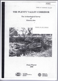
Book, The Plenty Valley Corridor: the archaelogical survey of historic sites, by Fiona Weaver, for the Ministry of Planning & Environment, 1989_
The Victorian Archaelogical Survey managed this study onbehalf of the Ministry for Planning & Environment. The study was intended to provide a brief history of Aboriginal and European occupation and use of the area and an outline of the geography of the chief areas of cultural heritage concern, with recommendations for protection of significant cultural sites and recommendations for further research, survey and consultation.115 p., photocopy, unbound. Illus., mapsplenty river -
 Bendigo Military Museum
Photograph - Commander 3rd Military District Visit – Army Survey Regiment Fortuna, Bendigo, 1989
This is a set of 16 photographs of a visit to the Army Survey Regiment, Fortuna, Bendigo by the Commander 3rd Military District BRIG P. Davies AM, ADC on the 23rd and 24th of October 1989. In this set BRIG P. Davies AM, ADC was taken on a tour through the orthophoto production area. In photos .1P to .3P and .6P BRIG P. Davies AM, ADC presented a productivity award to CO LTCOL John Winzar in Fortuna’s Ballroom. LTCOL Winzar was the CO of the Army Survey Regiment from 1987 to 1989. The WILD OR1 orthophoto projector and workstation featuring in photos .7P to.10P and .12P to .14P was introduced in the mid-1980s. It was the second-generation equipment used to orthorectify colour and monochrome film aerial photography, replacing the system introduced in 1973. See items 6124.5P, 6133.4P and 6228.4P for more photographs of orthorectification equipment. Photos .15P and .16P feature contractors preparing the foundations for the construction of Lithographic Squadron’s new Printing Building at Fortuna, Bendigo. The building was purpose built to house a new computer-controlled Heidelberg Speedmaster five colour lithographic offset Printing Press. The print room was named Wayzgoose Hall after a medieval printing house festival. See item 6131.18P for more photographs of contractors preparing the foundations. This is a set of 16 photographs of a visit to the Army Survey Regiment, Fortuna, Bendigo by the Commander 3rd Military District (CMDR 3MD ) BRIG P. Davies AM, ADC on the 23rd and 24th of October 1989. The photographs are on 35mm negative film and were scanned at 96 dpi. They are part of the Army Survey Regiment’s Collection. .1) to .3) - Photo, colour, 1989. L to R: CO LTCOL John Winzar, CMDR 3MD BRIG P. Davies AM, ADC. .4) - Photo, colour, 1989. L to R: SGT Chris Edwards, CMDR 3MD BRIG P. Davies AM, ADC, SGT Graham Johnston, unidentified, SGT Martin Evans. .5) - Photo, colour, 1989. L to R: WO1 Allan Adsett, WO2 Keith Fenton RE UK Exchange, SGT Bob Garritty, WO2 Rob Bogumil, SSGT Peter Imeson, WO1 Ralph Chant. .6) - Photo, colour, 1989. L to R: CO LTCOL John Winzar, WO2 Pat Lumsden, SSGT Di Chalmers. .7) - Photo, colour, 1989. L to R: MAJ Terry Edwards, CMDR 3MD BRIG P. Davies AM, ADC, CPL Graeme Priestley, WO2 Rob Bogumil, SGT Bob Garritty. .8) - Photo, colour, 1989. L to R: CMDR 3MD BRIG P. Davies AM, ADC, CPL Graeme Priestley, SGT Bob Garritty. .9) & .10) - Photo, colour, 1989. L to R: CPL Trevor King, CMDR 3MD BRIG P. Davies AM, ADC, MAJ Terry Edwards. .11) - Photo, colour, 1989. L to R: ADJT CAPT Greg Tolcher, unidentified. .12) - Photo, colour, 1989. CPL Pat Drury, WILD OR-1 Orthorectification Workstation. .13) & .14) - Photo, colour, 1989. CPL Pat Drury, WILD OR-1 Orthorectification Workstation equipment. .15) & .16) - Photo, colour, 1989. Contractors prepare the foundations for Lithographic Squadron’s new Printing Building - Wayzgoose Hall..1P to .16P – no annotations. CMDR 3MD BRIG P. Davies AM, ADC and the date are identified on the film negative sleeve cover sheet.royal australian survey corps, rasvy, army survey regiment, army svy regt, fortuna, asr, litho sqn -
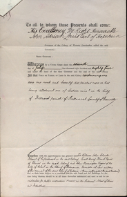 Federation University Historical Collection
Documents, Appointment of New Trustees of the Ballarat School of Mines and Industries, 1894, 1894
A deed appointing the Reverend Samuel Thornton as a trustee of the Ballarat School of Mines, after the death of former Trustee Rivett Henry Bland, and increasing the number of trustees by appointing James Millhinch Bickett. It includes a covering letter of Department of Lands and Survey Letterhead... and whereas it is intended that forthwith after the execution hereof the said land and premises shall be so transferred that the same may become vested in the said Sir William John Clarke and John Warrington Rogers jointly with the said Right Reverend Samuel Thornton, Andrew Anderson and James Millhinch Bickett now these prexsents witness that the said Governor as such Governor as aforesaid in exercise of the power for this purpose given to him by the said Crown Grant and of every other power enabling him doth hereby appoint the Said Right Reverend Samuel Thornton to be a trustee of the land in place of the said Rivett Henry Bland and James Millhinch Bickett to the addition trustees. .. .department of lands and survey, letterhead, legal, john adrian louis earl of hopetoun, william john clarke, rivett henry bland, john warrington rogers, trustees, ballarat school of mines, ballarat school of mines trustees