Showing 1438 items matching "allotment"
-
 Eltham District Historical Society Inc
Photograph, Liz Pidgeon, Heritage Excursion; East of Eltham, 6 Sep 2014, 20 May 2017
Newsletter No. 218, September 2014 September Excursion - East of Eltham Walk In Newsletter No. 197, March 2011, there was a brief history of Crown Allotment 15 Section 5 Parish of Nillumbik (CA 15) a parcel of land of a quarter of a square mile extending from Eucalyptus Road to Reynolds Road at the eastern extremity of Eltham. From the 1940s it was known as Stokes orchard. In later years it has been subdivided for residential purposes but leaving significant areas as power line and water supply reserves and bushland reserves that are habitat for the threatened For our excursion on 6th September we intend to walk through CA 15 to a bushland reserve east of Reynolds Road. The walk will traverse the boundary between suburban Eltham and the non-urban areas to the south and east. This is a pleasant walk through residential areas and bushland. Along the way we will discuss the early and more recent history of CA 15 as well as local natural history and geology. This walk is about 3.5 km in length and will take 2 to 2.5 hours. It will start at 2pm at the corner of Eucalyptus Road, Pitt Street and Nyora Road.Born Digitaleltham east, eltham district historical society, heritage excursion, activities, nyora road, reynolds road, gum tree road reserve, diosma road, stokes orchard, eucalyptus road -
 Ringwood and District Historical Society
Plan - Model Helicopter, Charles Medew, Ringwood, Victoria - 1909
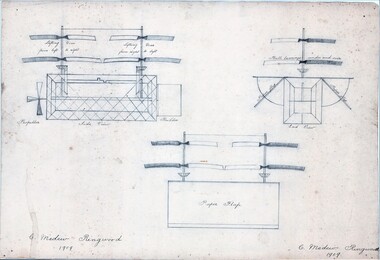
(Source: The First One Hundred Years by R.S. Medew and I.M. Bowman - A History of The Medew Family in Victoria - page 11 extracts) - Charles Turner Medew (1829-1915 ) arrived in Victoria from England in 1857. He eventually settled in Ringwood as the original purchaser of Crown Allotment 32, Section C, where he built his own home in 1888 and became well known locally "for his fine building work and stone masonry." ... "In his retirement, Charles Medew experimented with model helicopters. About 1910, at the age of 80 years, he was able to raise these helicopters to such a point of efficiency that, just with an elastic wound propeller, when released they could fly upwards to the height of the large oak trees." ... "(Also) In 1910, Charles obtained plans and made a model of the Wright Brothers' biplane entirely of wood, with laminated wood propeller and driven by twisted elastic bands." This model remained in his workshop for many years after his death and with his family's permission was eventually placed in the Melbourne Science Museum.3 pencil drawings showing assembled parts and sectional views of a model helicopter. -
 Bayside Gallery - Bayside City Council Art & Heritage Collection
Map, H.B. Foot, Plan of the Brighton Estate containing 5120 acres, first special survey at Port Phillip, c. 1842
This plan records the Brighton Estate, also known as Dendy's Special Survey. In 1840 Henry Dendy, a farmer in Surrey, England acquired a "Special Survey" from the Commissioners for Land and Emigration which gave him the right to choose land in Port Phillip for the low price of £1 per acre for 5120 acres. Dendy appointed Jonathan Binns Were, as his agent, who later became a partner. Together, Dendy and Were decided on an area 5 miles south from Melbourne, bounded by North Road, East Boundary Road, South Road and to the west by Port Phillip Bay. Their Brighton Estate was first surveyed by T. S. Townsend in May 1841 and was re-surveyed by Robert Hoddle. Dendy and Were were making plans to sell the land and advertised a 30-guinea prize for the best subdivision which was to be divided into a village, marine residences, suburban and cultivation allotments, with the remainder being divided into country sections. The competition was won by H.B. Foot, who planned the village around a reserve and crescents and a 'green belt' forming the town boundary. brighton estate, dendy's special survey, special survey, henry dendy, jonathan binns were, w.b. were, survey, plan, map, brighton, george ward cole, baker's lithographer, hibernian, subdivision, town planning, cartographic material, h.b. foot -
 Bendigo Historical Society Inc.
Document - H. A. & S. R. WILKINSON COLLECTION: CONTRACT OF SALE
Contract of sale of land dated 7th August, 1963 between Sandhurst and Northern District Trustees on behalf of the estate of W. H. Beecroft - Deceased (vendor) and Mr. A. L. Scinetti & Mr. J. Carriddi (purchaser). Solicitor for vendor: E. M. Monotti LL. B., View Street, Bendigo. Solicitor for purchaser: Manobo, Taylor & Taylor, Hargreaves Street, Bendigo. Property: 9 Short Street, Bendigo being parts of allotment 22A and 23 section 97C having a frontage of 65 feet 4 inches to Short Street and a depth of 82 feet 6 inches, being the land now comprised in certificate of title volume 2933 folio 421 and volume 4900 folio 928, together with all floor coverings, blinds, curtains and electric light fittings and shades. Price: 1,910 pounds.organization, business, h.a. & s.r wilkinson real estate -
 Bendigo Historical Society Inc.
Document - H. A. & S. R. WILKINSON COLLECTION: CONTRACT OF SALE
Contract of sale of land dated 29th April, 1957 between Miss M. J Schier & Mrs. M. Turner (vendor) and Mr. W. J. & Mrs. E. O. Sutton (purchaser). Property: land being part of Crown allotment 23 section G Parish of Mandurang county of Bendigo, land described in certificate of title volume 7374 folio 714 and situated Crusoe Road, Kangaroo Flat. Also all vendor's right title and interest in to that piece of land containing approx. 6 acres and adjoining the above mentioned land described in grazing licence no. 0349. Together with 6 roomed brick and weatherboard dwelling, all sundry outbuildings, electric light fittings, kitchen cabinet, blinds, curtains and floor coverings with exception of the carpet in the lounge. Price: 3,500 pounds. Attached Statement pursuant to section 34 of the estate agents' act 1956.organization, business, h.a. & s.r wilkinson real estate