Showing 14648 items
matching orbost-railway
-
 Orbost & District Historical Society
stamp
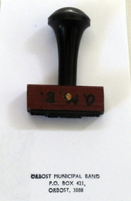
The first Orbost Brass Band was formed in 1889. Around 1908 the town band split and the Orbost Workers' Band was formed. Eventually the two bands merged in 1913 to reform as the Orbost Municipal Band under conductorship of Charles Spink. The Orbost Municipal Band continued on for many years but was disbanded and reformed many times. The last time it was reformed was in 1961. Today it no longer exists. Further info and Ref: In Times Gone By - Deborah HallThe various Orbost bands over the years played a major role in community activities providing entertainment and musical experiences for the many members.A rectangular shaped rubber stamp with a wooden handle. The stamp was used by the Orbost Municipal Band.O.M.B. in black on frontorbost-municipal-band seal stamp -
 Lakes Entrance Regional Historical Society (operating as Lakes Entrance History Centre & Museum)
Book, Leatch, May, The Ideal and the Actual - A Study of village settlements in the Bairnsdale area 1893-1915, 2008
The history of the Richardson family, settlers at Orbost, Victoria, and their association with the maritime trade of East Gippsland, particularly focused on their Snowy River paddle steamer, Curlip.ships and shipping, waterways, genealogy -
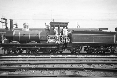
 Eltham District Historical Society Inc
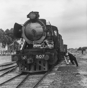
Photograph, George Coop, Steam locomotive J-507 shunting at Barnes Railway Station, NSW, Aug. 1963
Shunting at Barnes Railway Station (second stop from Echuca) on the Victorian Railways line to Deniliquin, NSW. Once a private line owned by the Deniliquin-Moama Railway Company. Barnes is the junction for a similar line to Balranald, NSW.Digital TIFF file Scan of black and white print Enlargement prints on textured paper (15.5 x 15.5 cm)george coop collection, j-507, j-class steam locomotive (vulcan foundry), barnes railway station -
 Hymettus Cottage & Garden Ballarat
Photograph, Ballarat West Railway Station staff
Railway Station staff were an important part of the social structure of both the railway and wider communities in the 1920s. Here Michael Taffe (1) is pictured with other staff members in front of the arches at the Ballarat West Railway Station.On back of mounting board, Mick Taffe, Middle, Head Porter. -
 Orbost & District Historical Society
souvenir, C 1980's
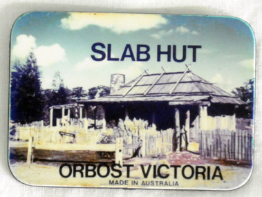
Used as a tourist souvenir of Orbost. Possibly made and distributed via the Slab Hut (Orbost Visitor Information Centre) in 1980's/1990's.The souvenir is an important component of the tourist experience with most tourists bringing back mementos and souvenirs as evidence. Fridge magnets are popular as souvenir and promotional items because they are relatively cheap to manufacture and very portable for tourists. This item is an example of a typical souvenir of Orbost. A small flat rectangular fridge magnet with a colour photograph of the Slab Hut (Orbost Visitor Information Centre) on one side. The other side is grey/black, At the top of the coloured side is "SLAB HUT" and below is "ORBOST VICTORIA made in Australia".souvenir-orbost fridge-magnet -
 Greensborough Historical Society
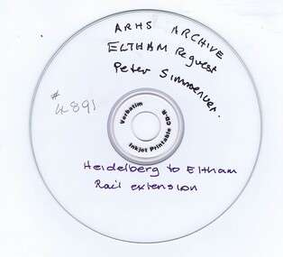
CD-ROM, Australian Railways Historical Society, Heidelberg to Eltham Railway: ARHS Archive, 30/01/2018
Report by Australian Railways Historical Society in response to a request for information on the Heidelberg to Eltham railway extension by Peter SimmenauerCD-Rom in plastic caseARHS Archive: Eltham Requestrailways, hurstbridge rail line -
 Melbourne Tram Museum
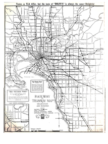
Map, Gawler and Drummond Architects, "Railway and Tramway Map of Melbourne and Suburbs", 1920's?
Map - photocopy - titled "Railway and Tramway Map of Melbourne and Suburbs", c1920 showing railways, cable, electric tramways and authorised electric additions. Shows the South Melbourne St Kilda tram line and some lines in the Footscray area as dotted. Prepared by Gawler and Drummond Architects. Has an advertisement for "Rolfes" tea along the top edge and "See Victoria First" - Government Tourist Office, corner of Swanston and Collins St.trams, tramways, map, footscray, st kilda, new tramway, melbourne, tourism -
 Eltham District Historical Society Inc
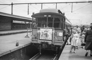
Photograph, George Coop, The Royal Train, on display at Spencer Street Railway Station during the 1954 Victorian Railways Centenary Exhibition, Sep. 1954
"V.R. Cavalcade" Centenary 1854-1954 Exhibition (11-25 Sep 1954) presented a model railway occupying about 1,400 square feet in the Lower Town Hall featuring a number of model railway working scale models. The exhibition also included a display of rolling stock, track, electrical and other railway equipment held at Spencer Street Railway Station.Digital TIFF file Scan of Kopdak 620 black and white negative transparencygeorge coop collection, royal train, display, spencer street railway station, v.r. cavalcade, victorian railways centenary 1854-1954 exhibition -
 Eltham District Historical Society Inc
Photograph, George Coop, The Royal Train, on display at Spencer Street Railway Station during the 1954 Victorian Railways Centenary Exhibition, Sep. 1954
"V.R. Cavalcade" Centenary 1854-1954 Exhibition (11-25 Sep 1954) presented a model railway occupying about 1,400 square feet in the Lower Town Hall featuring a number of model railway working scale models. The exhibition also included a display of rolling stock, track, electrical and other railway equipment held at Spencer Street Railway Station.Digital TIFF file Scan of Kopdak 620 black and white negative transparencygeorge coop collection, royal train, display, spencer street railway station, v.r. cavalcade, victorian railways centenary 1854-1954 exhibition -
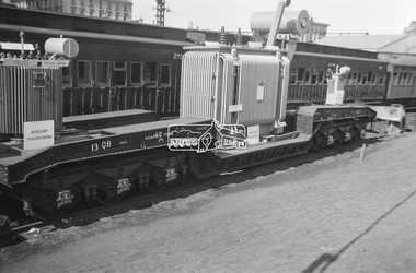 Eltham District Historical Society Inc
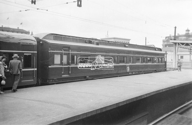
Photograph, George Coop, Power transformer on a QB boiler/flat wagon on display at Spencer Street Railway Station during the 1954 Victorian Railways Centenary Exhibition, Sep. 1954
"V.R. Cavalcade" Centenary 1854-1954 Exhibition (11-25 Sep 1954) presented a model railway occupying about 1,400 square feet in the Lower Town Hall featuring a number of model railway working scale models. The exhibition also included a display of rolling stock, track, electrical and other railway equipment held at Spencer Street Railway Station.Digital TIFF file Scan of Kopdak 620 black and white negative transparencygeorge coop collection, display, spencer street railway station, v.r. cavalcade, victorian railways centenary 1854-1954 exhibition, power transformer, qb boiler/flat wagon, qb-13 -
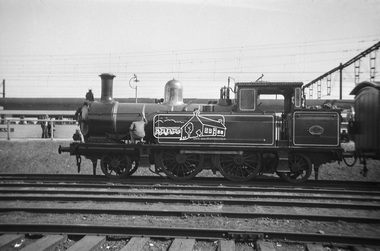 Eltham District Historical Society Inc
Photograph, George Coop, Steam locomotive E-class 2-4-2 on display at Spencer Street Railway Station during the 1954 Victorian Railways Centenary Exhibition, Sep. 1954
"V.R. Cavalcade" Centenary 1854-1954 Exhibition (11-25 Sep 1954) presented a model railway occupying about 1,400 square feet in the Lower Town Hall featuring a number of model railway working scale models. The exhibition also included a display of rolling stock, track, electrical and other railway equipment held at Spencer Street Railway Station.Digital TIFF file Scan of Kopdak 620 black and white negative transparencygeorge coop collection, display, spencer street railway station, v.r. cavalcade, victorian railways centenary 1854-1954 exhibition, e-class steam locomotive -
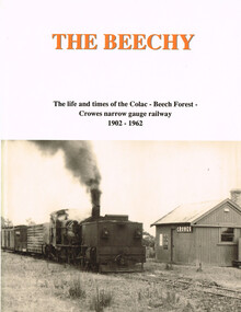 Otway Districts Historical Society
Book, The Beechy, 1992
The Beechy. The life and times of the Colac-Beech Forest-Crowes narrow gauge railway, 1902-1962; Norman Houghton; hard cover; viii, 176 p.; illus., maps; ISBN 0909340 28 5Printing - McPherson's Printing Group; Typesetting - Mackenzies Typesetting.the beechy; colac; beech forest; crowes; narrow gauge railway; norman houghton; locomotive operations; traffic; timber tramways; otway people; the garrett; trolley traffic; lean 1930s; -
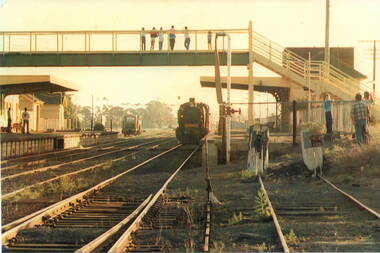 Sunbury Family History and Heritage Society Inc.
Photograph, c
The steam train has arrived at Number 2 platform at Sunbury Railway Station. Before diesel engines were used on the regional lines, steam trains were widely used. The pedestrian bridge spanning the railway line was replaced with a larger one to allow for disabled people's in 2001.A coloured photograph of a steam train arriving at a station with six people on the pedestrian bridge looking at the train and five other bystanders on the two platforms.steam locomotives -
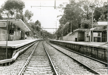 Whitehorse Historical Society Inc.
Photograph, Railway Station, Heatherdale|Railway Stations, 2000
Produced as one of a series of 24 prints commissioned by Nunawading & District Historical Society -|Theme: Intersections of Mitcham and Nunawading 2000/2001.|See also Series by P. Simmenauer on the same theme.Black and white photograph - print and negative of Heatherdale Railway Station, viewed from the Heatherdale Rail Crossing. L-R West bound station platform for travel to City of Melbourne, next station is Mitcham. Right hand side Eastbound platform - next stop Ringwood, where some trains travel S.E. to Belgrave and some N.E. to Lilydale. Heatherdale is last station in fare Zone 2 and 1st station in Fare Zone 3. Note Telstra Phonebox on platformheatherdale railway station -
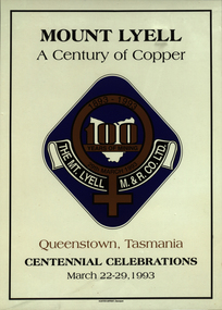 Federation University Historical Collection
Poster, Mt Lyell Mining and Railway Co Ltd Centennial Celebration, 1993
Laminated poster advertising the Mt Lyell Mining and Railway Company Limited Centennial Celebrations taking place in Queenstown 26th to 29th March 1993 'Mt Lyell A Century in Copper'.mt lyell, mining, centennial, copper 100 year -
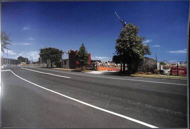 Port Melbourne Historical & Preservation Society
Photograph, James Lauritz, Railway Crescent demolition works, 1989 - 1990
Railway Crescent demolition works in preparation for Beacon cove redevelopment James Lauritz print of Port Melbourne, laminated (one of 18). Copies of slides produced for Port Melbourne Councillocal government - city of port melbourne, built environment, james lauritz, railway crescent, beacon cove -
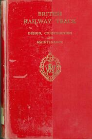 NMIT (Northern Melbourne Institute of TAFE)
Book: British railway track: design, construction and maintenance, 1964
Book of 533 pages titled 'British railway track: design, construction and maintenance', This copy is the third edition, published in 1964, edited by RA Hamnett, Published by The Permanent Way, Nottingham.railway tracks design and construction -
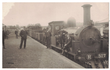 Linton and District Historical Society Inc
Postcard - Photograph, Steam Train, Linton Railway Station
Postcard which has a black and white image of a steam engine and carriages at Linton Railway Station. The R class engine was constructed at the Phoenix Foundry, Ballarat, between 1881 and 1886.Text, reverse: "Boy sitting on engine is Harold Morgan, man wearing bowler hat standing beside engine thought to be Mr Bourke, engine driver, father of Kitty and Lizzie. White house behind station master's cap, weatherboard cottage occupied by Mrs Howe, her daughter Myra and son Billy. Man on station wearing cap thought to be station master, Alec Thompson's father".linton railway station, steam engines, transport, railways -
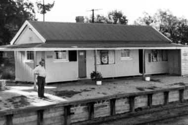 Linton and District Historical Society Inc
Photograph, Linton Railway Station, circa 1970, circa 1970
Black and white photograph of Linton Railway Station taken around 1970, showing the ticket office, waiting room, parcel/store shed and toilets. An unidentified man is standing on the platform.linton railway station -
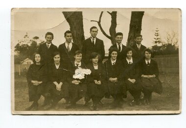 Orbost & District Historical Society
black and white photographs, 1920s - 1930s
These photographs are os students and staff of the Orbost Higher Elementary School. In photograph 3161.1 are; Back- F. Boucher; ? Bundle; Les Nielsen; Arnold;Keith Perry Front - Pen (Gilbert?); Elsie Pardew; Connie Tomlinson; Marion ? In 3161.3 are: Keith Nixon; Frank Perry; Lance Bridle; Arnold Ahern; Frank Boucher; F. ?; M. Nixon; Les Nielsen; Elsie Pardew; Myra Malcolm.Orbost High School / Orbost Secondary College has played a significant part in the education of senior students in the Orbost district . It is the sole senior educational institution. These photographs are representative of its history.Four black / white photographs associated with Orbost Elementary High School. 3161.1 is of two rows of school students in school uniform. Boys are in the back row standing and girls are seated in the front row. 3161.2 is a smaller photograph of two rows of girls in school uniforms. - four in the back row and three in the front. Both rows appear to be standing. 3161.3 is of students and teachers. The back row is standing and the front sitting. 3161.4 is of a row of girls in sports uniforms , each holding a hockey stick. They appear to be posed in front of goal posts. This is a smaller photograph.3161.1 - on back is a list of names. 3161.3 - on back is 1921 and a list of names 3161.4 on back is "Anne Richardson" and a hand-written Christmas shopping list -
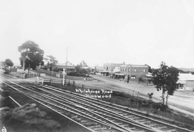
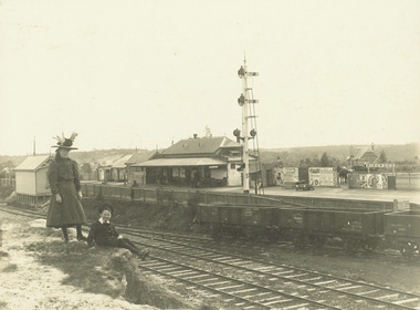 Ringwood and District Historical Society
Photograph, Ringwood Railway Station from Station St. looking north west - c.1910
Black and white photographs (2 copies - 1 original, 1 copy)Typed below photograph, "Ringwood Railway Station from Station St. looking north west. Old state school in background at Right. (App. 1910)". -
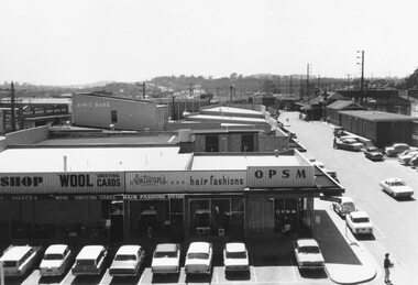 Ringwood and District Historical Society
Photograph, Railway Place, Ringwood - view from clocktower, December 1969
Black and white photograph. (2 images)Written on rear of backing sheet: "Railway Place, December 1969". Antwan's hair fashions and OPSM in foreground, ANZ bank in background, taken from clocktower. -
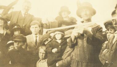 Ringwood and District Historical Society
Photograph, Mrs. Wedge cutting ribbon at opening of East Ringwood railway station. Mr. Everard, MLA on left. 16 May 1925
Black and white photographWritten on back of photograph, "Mrs. Wedge cutting ribbon at opening of East Ringwood railway station. Mr. Everard, MLA on left". 16 May 1925. -
 Ringwood and District Historical Society
Photograph, Maroondah Highway Central, Ringwood. Main St, looking west showing old railway crossing and station masters home in centre - 1918
Black and white photograph (2 copies)Typed below one copy: "Main St. Looking west showing old railway crossing and station masters home in centre - 1918". Typed below other copy: "Maroondah Highway looking west c1918. Showing old railway level crossing at left. Station masters residence in centre. Shops to right now Eastland car park." -
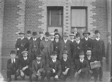 Stawell Historical Society Inc
Photograph, Stawell Railway employees including Mr W Boothey second from right -- before 1926
Stawell Railway employees before 1926 taken in front of Stawell Railway building. Mr W Boothey second from right.stawell railways transport -
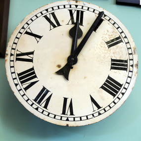 Orbost & District Historical Society
clock, mid-late 19th century
The new Post and ·Telegraph Office at Orbost was completed in 1898 This clock was presented by Mr A Cooper to the Postal Dept.in 1899 for erection outside the local post office. The clock arrived in Orbost on Monday 5th June 1899 in the charge of Captain Mortimer of the schooner Orbost. Before the clock could be placed in position permission had to be obtained from the postal department headquarters, and Mr Cooper nominated the appointment of Messrs W. Gluth Snr, J. Watt and H. James as a committee to take charge of the clock on behalf of the people of Orbost. In a letter to Mr Gluth at that time, Mr Cooper said, " If the people of Orbost receive this clock in the same goodwill in which it is given I shall be exceedingly pleased." Mr Alfred Cooper built the Orbost Club Hotel in the early 1890's. Captain Mortimer skippered the Schooner Orbost between Marlo and Melbourne until it was wrecked in 1904This clock is a significant part of Orbost's history.A metal clock from the Orbost Post Office. It is circular with black Roman numerals. It is open with no cover.orbost-post-office cooper-alfred schooner-orbost clock-orbost-post-office -
 Eltham District Historical Society Inc
Photograph, George Coop, Steam locomotive T-94 on display at Spencer Street Railway Station during the 1954 Victorian Railways Centenary Exhibition, Sep. 1954
Steam locomotive T-94 has been preserved and is currently on display at the Australian Railway Historical Society Museum at North Williamstown http://www.australiansteam.com/T%2094.htm "V.R. Cavalcade" Centenary 1854-1954 Exhibition (11-25 Sep 1954) presented a model railway occupying about 1,400 square feet in the Lower Town Hall featuring a number of model railway working scale models. The exhibition also included a display of rolling stock, track, electrical and other railway equipment held at Spencer Street Railway Station.Digital TIFF file Scan of Kopdak 620 black and white negative transparencygeorge coop collection, display, spencer street railway station, v.r. cavalcade, victorian railways centenary 1854-1954 exhibition, t-94, t-class steam locomotive -
 Hume City Civic Collection
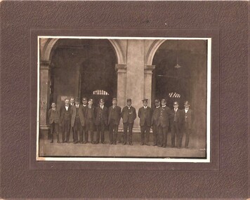
Photograph, C. 1900
A sepia coloured photograph of a group of well dressed men (possibly taken at the Railway Station; possible deputation to the railways dept. 1900)Typed sticker: DEPUTATION TO RAILWAYS DEPT. / OUTSIDE RAILWAY STATION / APPROX. 1900 Pencil: 34railways, 1900s, clothing and dress, george evans collection -
 Kew Historical Society Inc
Photograph - Regrading the Camberwell Railway Line near Burke Road, E.J. Dower, 1915
One of a series of photographs, taken by Edgar James Dower in the second decade of the twentieth century. Born and raised in Olinda, his family later moved to Surrey Hills. He worked as an adult as a clerk in the city office of the Metropolitan Gas Company, and in his role as a 'collector', he was able to photograph scenes including the construction of tramlines, railways and associated buildings in Kew, Hawthorn, Camberwell and Surrey Hills. Later he established a real estate agency with his brother - the E.J. Dower Real Estate Agency, Dandenong Office.The image is an historically significant record of the development of transport infrastructure which was used to connect Victorians in the first two decades of the twentieth century. This development resulted from increases in population and the consequent extension of Melbourne's suburbs. The photographs, both individually and collectively, richly detail the labour of workers and the tools and machinery used to create and extend Melbourne's public transport network in the years preceding and during World War 1.Digital copy of an original oval mounted photograph depicting workers regrading the Camberwell Railway line in the vicinity of Burke Road following the demolition of the original Camberwell Railway Station. Verso: "1915 / Regrading Camberwell railway line, near Burke Road / Taken by E.J.Dower."theme -- connecting victorians by transport and communications, theme - camberwell railway station, theme - travelling by train -
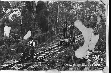 Southern Sherbrooke Historical Society Inc.
Photograph, Narrow gauge railway, Gembrook
B&W postcard sent to Jean Hermon's mother, Jane Beazley. It shows two men standing on a railway jigger and a third man in front of them, seated on a small three-wheeled vehicle on the track. All are dressed in hats, waistcoat, trousers and shirts. The railway line passes through thick bush. 'Narrow Gauge Rly. Gembrook' is printed at the bottom right corner. The original postcard has three patches where the surface is missing.