Showing 123797 items matching "main-road"
-
 Wodonga & District Historical Society Inc
Album - Hume Reservoir Australia Album - Plans and Progress Photos - River Murray Water Scheme, Department of Public Works, N.S.W, 1927
This set of photos is from a leather bound album bearing the inscription "HUME RESERVOIR AUSTRALIA" plus 'The Rt. Hon. L. C. M. S. Amery, P. C., M .P.' all inscribed in gold. It was presented to The Rt. Hon. L. C. M. S. Amery, P. C., M. P, Secretary of State for Dominion Affairs on the occasion of his visit to the Hume Reservoir on 2nd November 1927. This album is of local and national significance as it documents the planning and development of the Hume Reservoir up to 1927. It was the largest water reservoir in the British Empire. The album records the pioneering engineering work that went into its construction.1. Locality Plan and Plan of Dam. The dam is about ten miles by road upstream from Albury and about three-quarters of a mile below the confluence of the Mitta Mitta River and the Murray River. Its main features consist of a concrete portion across the bed of the river with earth embankment at both ends. The foundations throughout are on hard granite, found at an average depth of about 40 feet below the surface, the centre line being located to take advantage of the most favourable rock levels.Heading on page "WORKS UNDER RIVER MURRAY WATERS AGREEMENT/HUME RESERVOIR" Beneath top diagram "FIG. 1. ELEVATION" Beneath second diagram "FIG. 2. PLAN" On map "LOCALITY PLAN"hume reservoir australia, river murray waters scheme, hume weir diagrams, hume weir location -
 Bendigo Historical Society Inc.
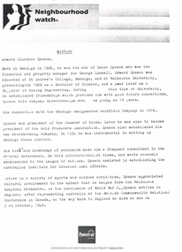
Document - LONG GULLY HISTORY GROUP COLLECTION: NEIGHBOURHOOD WATCH
BHS CollectionThree pages, the first titled Neighbourhood Watch. The second, dated 2/6/97, mentions a phone call to the City of Greater Bendigo about speaking to Marco in the Planning Department. The third, dated 30/5/97, also mentions Eaglehawk Heritage Society, Cornish Miners, Cornish Association, Long Gully School, Department of Main Roads, St laurence Court, Charles Fay, La Trobe History Department. It has Cheryl Wallis signature at the bottom of page.bendigo, history, long gully history group, the long gully history group - neighbourhood watch, edward clarence dyason, isaac dyason, george lansell, st andrew's college, melbourne university, bendigo amalgamated goldfield company, chamber of mines, gold producers association, bendigo mines limited, league of nations, australian institute for international affairs, melbourne syphony orchestra, world war ii, british commonwealth relations conference, powercor australia, city of greater bendigo, eaglehawk heritage society, cornish association, long gully school, department of main roads, st laurence court, charles fay, la trobe history department, cheryl wallis -
 Kew Historical Society Inc
Plan - Subdivision Plan, Boulevard Estate - Boulevard Section, 1930-1936
Pru Sanderson, in her groundbreaking ‘City of Kew Urban Conservation Study : Volume 2 - Development History’ (1988), summarised the periods of urban development and subdivisions of land in Kew. The periods that she identified included 1845-1880, 1880-1893, 1893-1921, 1921-1933, 1933-1943, and Post-War Development. These periods were selected as they represented periods of rapid growth or decline in urban development. An obvious starting point for Sanderson’s groupings involved population growth and the associated economic cycles. These cycles also highlighted urban expansion onto land that was predominantly rural, although in other cases it represented the decline and breakup of large estates. A number of the plans in the Kew Historical Society’s collection can also be found in other collections, such as those of the State Library of Victoria and the Boroondara Library Service. A number are however unique to the collection.The Kew Historical Society collection includes almost 100 subdivision plans pertaining to suburbs of the City of Melbourne. Most of these are of Kew, Kew East or Studley Park, although a smaller number are plans of Camberwell, Deepdene, Balwyn and Hawthorn. It is believed that the majority of the plans were gifted to the Society by persons connected with the real estate firm - J. R. Mathers and McMillan, 136 Cotham Road, Kew. The Plans in the collection are rarely in pristine form, being working plans on which the agent would write notes and record lots sold and the prices of these. The subdivision plans are historically significant examples of the growth of urban Melbourne from the beginning of the 20th Century up until the 1980s. A number of the plans are double-sided and often include a photograph on the reverse. This plan shows a subdivision with two sections: the ‘Boulevard Section’ and the ‘Riverside Section’. The first of these sections bordered Burke Road between Kilby Road and the farm beside the Yarra. Kilby Road, Munro Road, Burke Road and Old Burke Road bordered the 102 lots in the Boulevard Section of the plan. The streets within the Section included Walbundry Avenue, Inverness Way, Riverside Avenue, Cascade Street and Kyora Parade. These street names, at least in this subdivision plan linked the two Sections of the subdivision. At a later date, the City of Kew decided to alter the street names. Walbundry, Inverness, Riverside, Cascade and Kyora were all renamed as ‘Drives’ (e.g. Kyora Drive). The subdivision plan is of interest in that it names High Street in Kew as Doncaster Road. It also shows the location of the wooden church that was later removed to Yarraville on the corner of Kilby Road and High Street. The plan predates later developments such as the S. E. Dickens Supermarket.subdivision plans - east kew, boulevard estate, munro road -- kew east (vic.), kilby road -- kew east (vic.), burke road -- kew east (vic.), walbundry avenue -- kew east (vic.), inverness way -- kew east (vic.), riverside avenue -- kew east (vic.), cascade drive -- kew east (vic.), nyora parade -- kew east (vic.) -
 Bendigo Historical Society Inc.
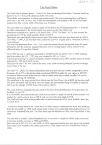
Document - ALBERT RICHARDSON COLLECTION: THE PEARL MINE
Typed, 2 page document, detailing the location and history of the operation of the Pearl Mine. The mine was located approximately 2 miles north west from the Bendigo Post Office. The main shaft was put down to 1613 feet and 3 subsidiary shafts were sunk, Information is given about the south shaft, originally the main shaft of the Great Extended Hercules and the east shaft, which was situated on the Sheepshead line.bendigo, mining, pearl company mine -
 Kew Historical Society Inc
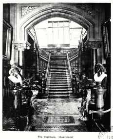
Photograph, The Vestibule, 'Goathland', 1901-1911
'Lost Glories: a memorial to forgotten Australian buildings' was published by David Latta in 1986. It tells the story of a number of significant Australian buildings that had previously been demolished. A chapter in the book was devoted to Goathland, later known as Tara Hall. To supplement the text, he sourced photographs from a range of suppliers, chiefly the Royal Women's Hospital which had once owned Tara Hall, but had sold it in 1960. This is one of the photographs donated to KHS by the author.The Vestibule, Goathland', 1901-11. The vestibule of Tara Hall (originally Byram, and later Goathland and Lowan). The vestibule was entered through a porte-cochère on the east side of the house. Visitors entered the mansion through the vestibule before progressing to the main hallway. The main rooms of the house were accessed through the latter on the ground and first floor. The photograph gives some idea of the decorative style of furnishings during this era. The Vestibule - "Goathland"byram, goathland, tara hall, lowan, studley park (kew), george ramsden, sir malcolm mceacharn, edward george kilburn (architect), studley park road (kew) -
 Charlton Golden Grains Museum Inc
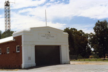
Photograph, Charlton Shire, Charlton Fire Station c. 1987, c.1987
The Charlton Fire Station was built in 1931.Colour photograph of the Charlton Fire Station. A single storey red brick building with a white frontage. A large entrance and three high high windows down the side. There is a plaque on the LH side of the main entrance that can't be clearly read.. The signage above the main entrance reads C.F.B.B. FIRE STATION 1931 There is a light above this sign. The fire tower is at the rear of the building. There is a low railing fence on the right side.charlton fire station, charlton fire brigade, public services -
 Whitehorse Historical Society Inc.
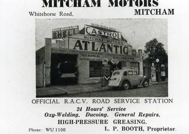
Photograph, Mitcham Motors, 1946
Black and white photo of Advertisement for Mitcham Motors, Whitehorse Road, Mitcham, Prop. L.P. Booth, taken from Broadbent's Official Road Guide, Jubilee Edition 1946, P.155 First published 1896. 566-568 Whitehorse Road now Mitcham Hotel Bottle Shop.mitcham motors, mitcham hotel -
 Whitehorse Historical Society Inc.
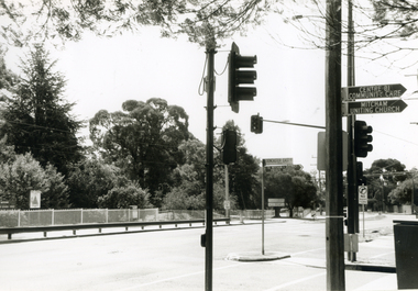
Photograph, Corner Doncaster East & Mitcham Roads, 2000
Produced as one of a series of 24 prints commissioned by Nunawading & District Historical Society -|Theme: Intersections of Mitcham and Nunawading 2000/2001.|See also Series by P. Simmenauer on the same theme.Black and white photograph - print and negative of Corner of Doncaster East and Mitcham Roads facing grounds of Mitcham Primary School. Note road and street signage: Doncaster East Road; Mitcham and District Private Hospital; Centre of Community Care; Mitcham Uniting Church. (See also NP2324)doncaster east road mitcham, mitcham road, mitcham, mitcham primary school no. 2904, street signs -
 Kew Historical Society Inc
Photograph - Road construction in Studley Park Road, c. 1960
Tom Bentley (1912-1993) was born in Lancashire (UK). From circa 1951, he was the Overseer/Superintendent of Outdoor Works for Kew City Council. Until his retirement in the 1970s, he was based at the Kew Council Depot, located in the former MTB Horse Tram Depot on the corner of Disraeli and High Streets, Kew. Accompanying the set of twelve photographs is a 12-page illustrated biography of the Bentley and Plumridge families, separately kept in the 'Bentley' subject file.Duplicate black and white positive print photograph of road works in Studley Park Road, Kew, carried out under the supervision of Tom Bentley, Overseer/Superintendent of Outdoor Works for the City of Kew. The blurred photograph shows Council-owned vehicles used for road construction and council workers.city of kew, public works, tom bentley, road works -
 Kew Historical Society Inc
Plan - Subdivision Plan, Maxwelton, Kew, 1920-1940
Pru Sanderson, in her groundbreaking ‘City of Kew Urban Conservation Study : Volume 2 - Development History’ (1988), summarised the periods of urban development and subdivisions of land in Kew. The periods that she identified included 1845-1880, 1880-1893, 1893-1921, 1921-1933, 1933-1943, and Post-War Development. These periods were selected as they represented periods of rapid growth or decline in urban development. An obvious starting point for Sanderson’s groupings involved population growth and the associated economic cycles. These cycles also highlighted urban expansion onto land that was predominantly rural, although in other cases it represented the decline and breakup of large estates. A number of the plans in the Kew Historical Society’s collection can also be found in other collections, such as those of the State Library of Victoria and the Boroondara Library Service. A number are however unique to the collection.The Kew Historical Society collection includes almost 100 subdivision plans pertaining to suburbs of the City of Melbourne. Most of these are of Kew, Kew East or Studley Park, although a smaller number are plans of Camberwell, Deepdene, Balwyn and Hawthorn. It is believed that the majority of the plans were gifted to the Society by persons connected with the real estate firm - J. R. Mathers and McMillan, 136 Cotham Road, Kew. The Plans in the collection are rarely in pristine form, being working plans on which the agent would write notes and record lots sold and the prices of these. The subdivision plans are historically significant examples of the growth of urban Melbourne from the beginning of the 20th Century up until the 1980s. A number of the plans are double-sided and often include a photograph on the reverse. A number of the latter are by noted photographers such as J.E. Barnes.The subdivision, ‘Maxwelton’, included four lots in East Kew, at the northwest corner of Burke Road and Cotham Road. Lot 3 is identified as the location of an existing house. The site of the subdivision equates to that parcel of land where a contemporary block of three storey apartments at 1245 Burke Road is now located.subdivision plans - kew, mazwelton subdivision, burke road -- kew (vic.), cotham road -- kew (vic.) -
 Ringwood and District Historical Society
Photograph, Bedford Rd Railway Crossing, Ringwood, Late 1980 (3 Views)
SS0349b and c: Written on back of photograph, "Late 1980. Bedford Road crossing." SS0349d: Written on back of photograph, "Late 1980. Bedford Road crossing looking south." -
 Ringwood and District Historical Society
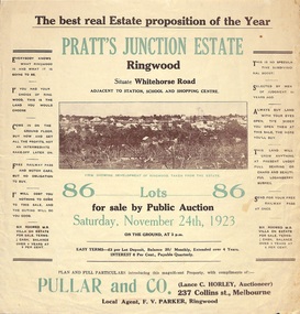
Flyer, Brochure for Land Sale By Public Auction, Pratt's Junction Estate, Ringwood, Victoria - 1923
Folded double-sided brochure advertising 86 residential lots for sale by Public Auction at 3pm, Saturday, November 24th, 1923, with town photographs, map of subdivision and summary of local features and services. Subdivision plan includes Whitehorse Road, Oliver Street, Georges Road, Junction Street, and six room weatherboard villa for sale. Local Agent - F.V. Parker, Ringwood. -
 Uniting Church Archives - Synod of Victoria
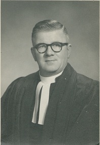
Photograph, Undated c.1955
The Rev John Edward Smith was born in 1900, ordained in 1932 and died 1986. He served in 1935 Port Campbell; 1937 Wychproof; 1940 Werribee; 1947 Bendigo St. John's; 1952 Albury; 1955 Essendon St. John's and 1967 Apollo Bay. He retired in 1969 and in 1971 was appointed Emeritus Presbytery Melb. West.Black and white head and shoulders studio portrait of Rev. John Edward Smith. He is wearing glasses, looking at the camera and is wearing his clerical regalia. The back has the photographer's name and address, also that of the Rev Smith. It laso has various numbers and measurements indicating that the photograph was to be used in a publication."Rev. J. (John) Edward Smith. 853 Mt. Alexander Road, Essendon, W.5 PHONE FU1085" "The Dover Studio 17 HOLMES ROAD, MOONEE PONDS"presbyterian ministers, john edward smith, st john's presbyterian church essendon -
 Flagstaff Hill Maritime Museum and Village
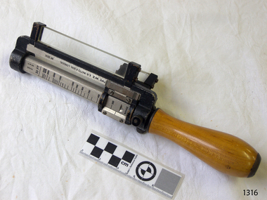
Rangefinder, E R Watts & Sons, 1930-1945
E. R. Watts and Son, makers of theodolites and other surveying instruments, of 123 Camberwell Road, London. The company was established in 1856 by Edwin Watts at twenty-three he had saved £100 from his earnings to start the business with his staff consisting of one boy and later Alexander Clarkson as an apprentice with the workshop a small room over a Bemondsey stable. Watts' first order was from Negretti and Zambra for a mining dial Alexander Clarkson In the early days the firm worked mainly on marine compasses. Edwin Watts would go down to the Docks to adjust the compasses once they had been installed on the ships. In May 1873 the business moved to larger premises a house with a garden. The workshop was also the home of Mr and Mrs Watts and their five sons and three daughters. By now there were fifteen to twenty men employed by the firm. The company were commissioned to supply the Theodolites and Levels for the construction to the Canadian Pacific Railway in 1881. Towards the end of the century, the firm began to make heliographs continuing to produce them for the government until just before the Second World War when by agreement assigned their manufacture to another firm. 1904 The first dividing engine was completed by George William Watts. It was so remarkable an instrument at the time and for years afterwards, In 1907 Arthur Ames went to Canada and started an organisation in Winnipeg in 1909 this became a separate company called E. R. Watts and Son Ltd. of Ottawa. This firm developed considerably and was eventually with the co-operation of three other instrument companies (Cambridge Instrument Co, Ross, and Negretti and Zambra), were reconstituted as ”Instruments Ltd” of Ottawa and Toronto. During the next ten years, the firm expanded greatly to include glass grinding, leather work, dividing and engraving, testing, adjusting and packing. This expansion was continued during the First World War when workshops were completed and the machinery installed and running within eleven weeks from the start of construction. During the war, a Sergeant Coles, among the rats, lice and mud of the trenches, fitted various bits of scrap into his cocoa tin and made the first Flash Spotter for plotting the positions of enemy guns. Coles was rushed home to the firm's factory where he and George William Watts designed a spotter not made out of a cocoa tin and as a result, the Watts Vertical Force Variometer was developed during WWI. Other Watts instruments made in the First World War included the Light Mountain Theodolites which were taken on Mt Everest expeditions. In 1919 ER Watts and Sons was incorporated as a limited company and in 1939 G. A. Whipple joined the Board of Directors. Shortly afterwards, Frank Charles Watts died having been Chairman of the firm for over 37 years and seen it through the First World War with all its expansions and difficulties. He was succeeded by his brother George William Watts with the vacant post of Managing Director being filled by G. A. Whipple. During the Second World War, the company expanded further and the number of employees rose to well over 1,300. In 1946 Watts acquired 78% of Adam Hilger and the microscope maker James Swift and Son Who were Manufacturers of Theodolites, Levels, Alidades, Meteorological Instruments, Variometers, and many other types of scientific instruments Then in 1948 the company amalgamated with Adam Hilger as Hilger and Watts which was then incorporated as a public company.Naval Rangefinder with a vertical wooden handle, and an arrangement of optical lenses. Three reversible brass inserts calibrated on both sides in yards, correspond to various base heights, (20 and 25 feet, 30 and 35 feet and 40 and 50 feet). They are fitted along the axis of the instrument. When the scale for the appropriate base height is selected and inserted, the carriage can be slid for coincidence and the distance read at the index mark on the sliding carriage.inscribed "Rangefinder Cotton Type Mk II" Calibrated scale up to 5000 yds (50 ft), 5000 yds (35 ft), 4000 yds (25 ft) made by E. R. Watts & Son.flagstaff hill, warrnambool, shipwrecked coast, flagstaff hill maritime museum, maritime museum, shipwreck coast, flagstaff hill maritime village, great ocean road, rangefinder, cotton type, e r watts & sons, naval range finder, marine equipment -
 Bendigo Historical Society Inc.
Photograph - Rocky Vale Villa, April 2016
The Beebe name was well-known in Bendigo in the last quarter of the 19th and the early part of the 20th centuries. From 1875, William Beebe senior, monumental mason, occupied a site in the centre on the city, in Mitchell Street opposite King Street. Death was more part of life in those days, and the Beebes were there to provide the burial monuments. Later, he took his sons into the business, which grew as Beebe and Son. Many examples of their work can be found in the local cemeteries. William Beebe senior (1830-1891) was born in Rutland, the smallest English county in 1830, to stonemason Chamberlain Beebe and Susannah Clements. William emigrated to Victoria in 1854 and after engaging on unknown works in Port Fairy, Dunkeld, and Melbourne arrived in Bendigo. His obituary records that he commenced work here on the site of the Bank of Australasia (opposite the Shamrock Hotel), which would have been no later than 1856. He took up a 13 acre selection on the site of Rocky Vale Villa in 1864 and continued to select or purchase further parcels of adjoining land until he owned some 150 acres, much of it unfit for cultivation. He was a keen gardener and had a garden and orchard around the house. William took over 20 years to build the two-story sandstone and granite house "Rocky Vale Villa". The house was constructed from sandstone sourced "from an adjacent ridge of rocks" (Bendigo Advertiser 28/9/1891). Granite from Harcourt was used for lintels and quoins. Not long before he died, William was still adding to the house. In the Codicil to his will, he states that "I have just built and completed two additional rooms to my Dwelling house situe at Inglewood Road aforesaid" (dated 19/9/1891). William died one week later on the 26th September 1891.Photographs of a field trip to Rocky Vale Villa, 7 Wicks Road, Maiden Gully, Bendigo by the Bendigo Historical Society.history, bendigo, rocky vale villa maiden gully, william beebe stonemason bendigo -
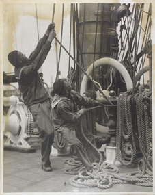 Mission to Seafarers Victoria
Photograph - Photograph, Black and white, McIlwraith & McEwan, Early 20th Century
The pencilled inscription at the back of the Mount indicateur the photograph was taken for a newspaper. Likely between 1920-1930, maybe for the Grain Race.An illustrative image demonstrating the effort involved in hauling ship's rigging and mast ropes. Also provides a snapshot of seamen's clothing from an early 20th C period. Mounted large black and white photographic print; the mount is friable ( see condition report) shows 2 seamen in working uniform hauling on main mast ropes and riggingPencil inscription on back of mount : McIlwraith & McEwan / measurements indecipherable/ Thursdayseamen, rigging, sailing ships, crews and ships, life on board, ropes, mcilwraith and mcewan, shipping companies -
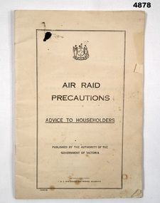 Bendigo Military Museum
Book - AIR RAID PRECAUTIONS, H.E.Daw, C.1941
This book is about advice to Victorians Australia.Book, Air raid precautions, advise to Householders, off white paper 47 pages, contains Air Raid signals, 4 main sections, diagrams and sketches of shelters.air raid, precautions, householders -
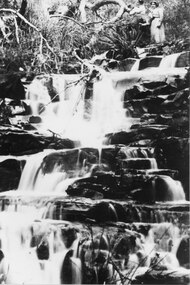 Halls Gap & Grampians Historical Society
Photograph - B/W
Location and women not identified.The photo shows two young women, at the top of the picture, beside a cascading waterfall. A large, twisted, leafless branch of a tree extends out over the main drop of the falls.scenery, waterfalls -
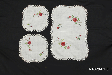 Whitehorse Historical Society Inc.
Textile - Dressing Table Set, circa 1958
Donor embroidered, but not edging. For her glory box in 1958. Significance of Item - An example of the contents of a glory boxThree piece dressing table set - Main mat scalloped rectangular shape and two mats of scalloped squared shape. All embroidered with red/pink, brown flowers.nonehandcrafts, embroidery -
 Rutherglen Historical Society
Image
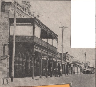
One of a group of photographs of Rutherglen collected from magazines (Pix or People or Post), then pasted onto orange paper, date unknown. This one is of the Victoria Hotel in Main Street.victoria hotel, rutherglen -
 Rutherglen Historical Society
Image, 1960s
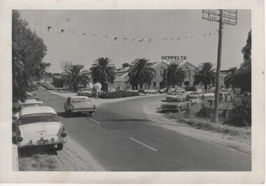
The buildings of Seppelts winery had previously been the D.G. Hamilton cellars, and are now Tuileries and the tasting rooms for Rutherglen EstatesBlack and white photograph, taken during wine festival, showing a large number of cars parked near the Seppelts Winery at the intersection of Main Street and Drummond Street Rutherglenwine festival, rutherglen wine festival, seppelts, tuileries, rutherglen estates -
 Mt Dandenong & District Historical Society Inc.
Photograph, Olinda 1903
Olinda Main Street 1903 with Peter Witt's blacksmith in the foreground opposite Hodges' Smithy and the Mission Hall. Reverse of photograph has handwritten description by John Lundy-Clarke.Olinda 1903 One of the photos which were used to compile the Panorama blacksmith, peter witt, frank hodge, mission hall -
 Lilydale RSL Sub Branch
Ration pack
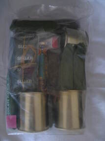
ADF CR1M - Combat ration, One man This CR1M is intended to feed one soldier for 24 hours and contains two (2) main meals, a snack and sundry items.Australian Defence Force -
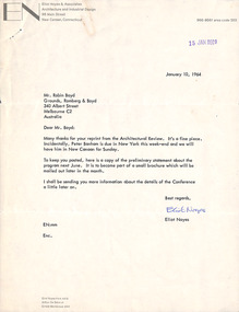 Robin Boyd Foundation
Letter, Eliot Noyes, Eliot Noyes to Robin Boyd, 10.01.1964
This letter to Robin Boyd from Eliot Noyes, an American architect and industrial designer, is the first of two held by The Robin Boyd Foundation (see also D419). It includes a copy of the preliminary statement for the International Design Conference in Aspen in 1964. The preliminary statement is two pages long, dated 16 December 1963. Robin Boyd has written many comments in pencil in the margins. The letter also thanks Boyd for his reprint from Architectural Review.Letter plus two page document for the International Design Conference. On letterhead Eliot Noyes & Architects, Architecture and Industrial design, 95 Main St, New Canaan, Connecticut.Robin Boyd has written many comments in pencil in the margins.international design conference, noyes -
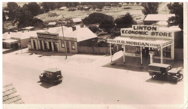 Linton and District Historical Society Inc
Photograph, H.R. Morgan, Economic Store, Sussex Street, Linton
Black and white image of a general store in the main street of Linton. Petrol bowser at front of store. Other commercial businesses to the right. Two early model vehicles in street.commercial buildings, linton -
 Moorabbin Air Museum
Book - Largely photos but with some accompanying notes re, Pictorial History of the FRENCH AIR FORCE VOLUME 2 1941-1974, Andre Van Haute, Pictorial History of the FRENCH AIR FORCE VOLUME 2 1941-1974, 1975
Largely photos but with some accompanying notes re, Pictorial History of the FRENCH AIR FORCE VOLUME 2 1941-1974Cover jacket showing colour photos of top Mirage jet in flight, below twin engine transport plane in flight, main title in blue against black backgroundnon-fictionLargely photos but with some accompanying notes re, Pictorial History of the FRENCH AIR FORCE VOLUME 2 1941-1974 -
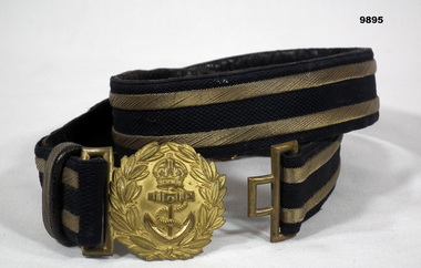 Bendigo Military Museum
Uniform - BELT, Unknown
Part of the collection of "William (Bill) THOMASON". Refer Cat no. 4136P. The belt is most likely from British Navy. Dress Belt - Navy. Black belt with gold stripes. Decorative gold buckle with Crown and Anchor in centre. Small internal strap on inside of main belt. Size 34.belt, navy, uniform, william (bill) thomason collection -
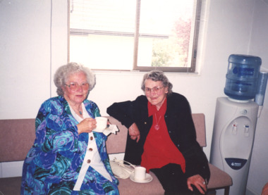 Lakes Entrance Historical Society
Photograph, Heather Bryant, Marie Fish and Stella Rau. 2002, 1/09/2002 12:00:00 AM
Colour photograph of LERHS members Marie Fish and Stella Rau after funeral of past member Glad Scarce at Baggs Funeral Chapel Main Street Bairnsdale Victoriafunerals., history group members -
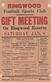 Ringwood and District Historical Society
Poster, Ringwood Football Sports Club Gift Meeting, Ringwood Reserve - 1949
Programme of running and cycling events and highland dancing competitions with details of entry fees and prize money - Saturday January 8 (1949).Proceeds in aid of Recreation Ground improvements. Advertisers - T. Mathieson Service Station, 128 Whitehorse Road Ringwood, R. France Fruit & Vegetables, 203 Whitehorse Road Ringwood, R.W. Porter Hire Car Service, Phone WU6334, H.J. Bently Timber Merchant, Phone WU6031, Kenneth Marshall Jeweller and Watchmaker & Gifts, Ringwood, Roy Hill Hairdresser and Tobacconist, Opposite Station, Whitehorse Road, Ringwood, R. White Shoes, 30 Whitehorse Road, Ringwood, Phone WU6384, K. Rees Tailors, 100 Whitehorse Road, Ringwood, Stoney's Super Service, Sporting & Electrical Goods, 165-7 Whitehorse Road, Ringwood, A.S. Bailey, Chemist, 173 Whitehorse Road, Ringwood, Phone WU6234. -
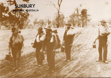 Sunbury Family History and Heritage Society Inc.
Postcard, Australian Yesteryear Cards, Sunbury Victoria Australia, 1905
Although the caption reads'Sunbury, Victoria, Australia', the picture is not of any specific Sunbury event. Instead it typifies frequent occurrences that took place across the area from the 1850s to the early years of the nineteenth century when people travelled along roads to the goldfields during the gold rush era and later seeking work during times of economic stress.The picture has captured an era in Australia's history when people were on the move seeking their fortunes on the gold fields or seeking work during times of economic depression. A non-digital sepia photograph in post card format of five men carrying swags and their billies as they walk along an unmade road. Written along the top LH corner is 'Sunbury, Victoria, Australia'. On the back of the card in the lower RH corner is information explaining expressions relevant to the swagman traditions in Australia.swagmen, sunbury