Showing 16245 items
matching '' place
-
 Victorian Aboriginal Corporation for Languages
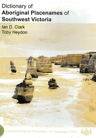
Book, Ian D Clark et al, Dictionary of Aboriginal placenames of Southwest Victoria, 2002
Dictionary including Indigenous and European place names. Origins are given.maps, b&w photographsdhauwurd wurrung, giraiwurrung, djargurd wurrung, gadubanud, buandig, gulidjan, moyne, corangamite, colac-otway, wimmera, glenelg, warrnambool -
 Victorian Aboriginal Corporation for Languages
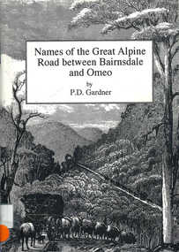
Book, P D Gardner, Names of the Great Alpine Road between Bairnsdale and Omeo : their origins, meanings and history, 1997
Lists the place names along the Victorian Alps, with descriptions and meanings.Maps, b&w illustrations, b&w photographsgunnai, kurnai, ngarigo, jaitmathang, brabiralung, tongiomunjie, tambo, tongio, bruthen, tambo, mount stringy, swifts creek -
 Victorian Aboriginal Corporation for Languages
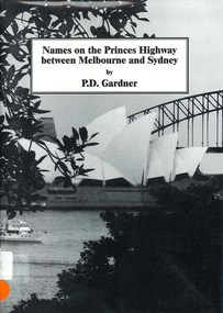
Book, P D Gardner, Names on the Princes Highway between Melbourne and Sydney : their origins, meanings and history, 2000
Place name list in a specific area. Giving descriptions and meanings.Maps, b&w illustrationsdandenong, genoa, south coast nsw, yarra river, moruya, kiama, captain cook, east gippsland, rosedale -
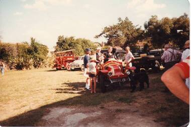
 Clunes Museum
Photograph
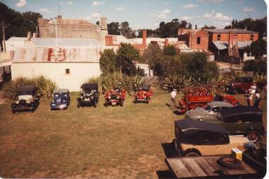
COLLINS PLACE, CLUNES. VINTAGE CAR RALLY FEB. 1984local history, photography, photographs, events and celebrations -
 Clunes Museum
Photograph
COLLINS PLACE, CLUNES. VINTAGE CAR RALLY FEB. 1984local history, photography, photographs, events and celebrations -
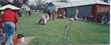 Clunes Museum
Photograph
COLOUR PHOTOGRAPH ENTERTAINMENT AT COLLINS PLACE, FRASER STREET, CLUNESlocal history, photography, photographs, events and celebrations -
 Whitehorse Historical Society Inc.
Article, Know your city, 197-?
Places of interest in Nunawading. Describes early pioneers and properties in the area.Places of interest in Nunawading. Describes early pioneers and properties in the area.Places of interest in Nunawading. Describes early pioneers and properties in the area.antonio park mitcham, city of nunawading, schwerkolt cottage, slater, william, burwood east primary school no. 454, mcclelland, john, witt, william, tally ho boys home, stanley works pty ltd -
Whitehorse Historical Society Inc.
Article, Service reservoirs
Article on service reservoirs and their place in the system.Article on service reservoirs and their place in the system. Photo copy with pictures.Article on service reservoirs and their place in the system. water supply, mitcham reservoir -
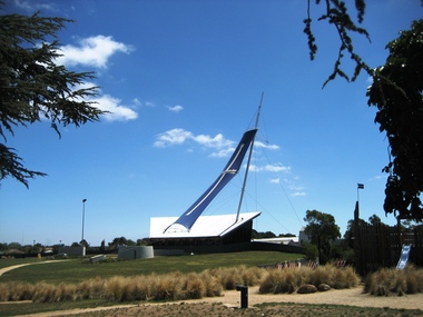 Ballarat Heritage Services
Photograph - Photograph - Colour, Clare Gervasoni, Eureka Stockade Centre, 2008, 14/02/2008
Colour photograph of the Eureka Stockade Centre with the Eureka Sail in place.eureka stockade centre, eureka sail, eureka stockade gardens -
 Ringwood RSL Sub-Branch
Booklet, London
70 pages, black and white photos of places of interest in London -
RMIT GSBL Justice Smith Collection
Book, Butterworth & Company (Australia) Ltd, Practice of the County Court of Victoria : being an annotation of County Court act 1958, and the rules of court thereunder, Foreign judgments act 1962, Instruments act 1958, Imprisonment of fraudulent debtors act 1958, and Service and execution of process act 1901-1963 (Com.), 1965
Previous owner: T. H. SmithIncludes multiple loose-leaf amendments placed in appropriate placescourt rules -- victoria -
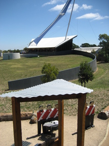 Ballarat Heritage Services
Photograph, Lisa Gervasoni, Eureka Stockade Centre, 14/02/2008, 14/02/2008
Photographs of the original Eureka Stockade Centre, with Eureka sail in place. eureka stockade centre, eureka sail, eureka stockade -
Port Melbourne Historical & Preservation Society
Audio - Human face of Port Melbourne places, Jill Barnard, 23 Aug 2012
Jill Barnard discussing the human face of Port Melbourne places.Duration 00:45:45built environment, families, jill barnard -
 Yarra Ranges Regional Museum
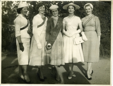
Photograph, 1957
The first Lildale Show Girl competition was held in 1957 as part if the annual Lilydale Show. The Lilydale Shoe had stopped during the war years and reformed in 1954. The show was restarted by John Plant and Lloyd Gill ( owners of the Lilydale Express) Black and white photograph of the five women who won the highest places in the First Lilydale Show Girl competition in 1957. The winner of the competition, Robyn Hoyland is pictured centre, second prize, Susan Mandel is pictured to the far right, third place is Faye Hart, who is standing second from from right. Fourth place is Leslie knee, second from left and fifth place is Lynette McDonald who is standing far left. Verso: Inscribed in blue biro ink, u.r. '1st Lilydale Showgirl Comp. / 1957 / SUSAN MANDEL 2ND / FAY HART 3RD / ROBIN HOYLAND 1ST / LESLIE KNEE 4TH / LYNETTE MCDONALD 5TH 1950s, lilydale show -
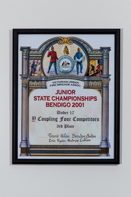 Wangaratta Urban Fire Brigade
framed certificate
Victorian Fire Brigades Assoc. JUNIOR STATE CHAMPIONSHIPS BENDIGO 2001 Under 17 D COUPLING FOUR COMPETITORS 3rd place Travis Allen, Brendan Gordon, Erin Ryan, Andrew Ludlowcertificate framed by a simple black plastic frameVictorian Fire Brigades Assoc. JUNIOR STATE CHAMPIONSHIPS BENDIGO 2001 Under 17 D COUPLING FOUR COMPETITORS 3rd place Travis Allen, Brendan Gordon, Erin Ryan, Andrew Ludlowjuniors, travis allen, brendan gordon, erin ryan, andrew ludlow, 2001 -
 Hume City Civic Collection
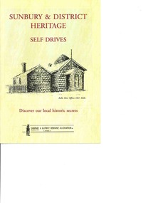
Booklet - Self Drive booklet, Sunbury & District Heritage Self DRives, 2012
The booklet features 4 self drives to points of historic interest throughout the Sunbury region.A 26 page booklet printed on cream paper with black and white drawings of places of interest throughout and a reproduction of a coloured mural on p 2. There are 4 drives recommended to places of interest in the district.non-fictionThe booklet features 4 self drives to points of historic interest throughout the Sunbury region.sunbury & district heritage association inc., self drive booklet, heritage, sunbury -
 Nhill Aviation Heritage Centre
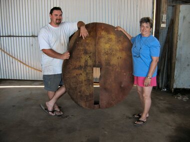
Target, 1941
This was the main target used for bombing and strafing practice during WWII by trainees at the RAAF Air School at Nhill.Original target from the bombing range. Other temporary wooden targets were used but this is the only original target that now exists.This target is made of 10mm steel plate. Two circles approximately 1.5 metres in diameter are slotted and joined at right angles so that when viewed from a distance would always appear as a round ball. Includes four support stays approx. 14 foot long 3" steel pipe with flattened ends.It is marked in several places due to being hit by bombs.target, -
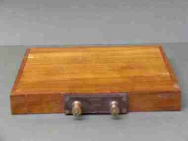 Federation University Historical Collection
Scientific Instument, Capacitor
DEFINITION microfarad Posted by: Margaret Rouse WhatIs.com Contributor(s): Kenda, Jack Clements The microfarad (symbolized µF) is a unit of capacitance, equivalent to 0.000001 (10 to the -6th power) farad. The microfarad is a moderate unit of capacitance. In utility alternating-current (AC) and audio-frequency (AF) circuits, capacitors with values on the order of 1 µF or more are common. At radio frequencies (RF), a smaller unit, the picofarad (pF), is often used. This unit is equal to .000000000001 (10^-12) µF. In RF scenarios, capacitances range from about 1 pF to 1,000 pF in tuned circuits, and from about 0.001 µF to 0.1 µF for blocking and bypassing. At audio frequencies (AF), capacitances range from about 0.1 µF to 100 µF. In power-supply filters, capacitances can be as high as 10,000 µF. Capacitor, 1/3 M.F.D. (microfarad) within wooden insulating box. Two terminal posts set in an insulating box. Maker's name and place 1/3 M.F.D No. 34402scientific instrument, capacitor, electrical engineering, laboratory -
Bendigo Historical Society Inc.
Document - HER MAJESTY'S WANGARATTA - VICTORIAN COMMERCIAL TRAVELLER'S CHORAL PARTY, 27 September, c1916
Her Majesty's Wangaratta - Victorian Commercial Traveller's Choral Party. Vocalists, Instruments, Entertainers. Wednesday, Sept. 27th. Proceeds in Aid of Wangaratta Hospital. Box Plan at Bickerton's. Charles R Hershchell Musical Director. Walter A Jack, Hon. Sec. PART 1 The Traveller, Mr C Harold Oakley. 2 The Soldier's Chorus, Victorian Commercial Travellers' Choral Party. 3 Sing Me A Song of the South, Mr Horace J Wood. 4 'The Battle Eve', Messrs. W T P Sutton and Harry Pride. 5 'The Highland Brigade Burying Their Dead' Captain Reid, D.S.O. 6 'Doan yer cry, ma Honey,' 'Laugh and Grow Fat,' The C.T. Choral Party. 7 unnamed part by Mr Gill Gliddon. 8 'The Song the Anvil Sings,' Mr E L Jones. 9 'La Reve De Armour,' Mr Charles R Hershell. 10 'Johnathan Jones,' Mr Harry Pride. 11 'March of Israelites,' The C.T. Choral Party. Part 2. 1 Mr C Harold Oakley, his own composition. 2'A Cradle Song,' The bachelors of the Choral Party and married men. 3 Duet for Basses, Mr Vic Porter and Mr Harry Pride. 4 feat of Legerdemain, Captain Reid. 5 'Ma Honolulu Lady,' Mr E L Jones. 6 A slight interruption in the programme while Mr Gill Gliddon amuses himself and possibly the audience. 7 'The Lost Chord' Mr Chas R Herschell. 8 'Blow, Blow, Thou Wintry Wind,' Mr Horace J Wood. 9 'Little Tommy Went a-Fishing,' and 'The Mellow Melon,' C T Choral Party. Baton: Mr Chas R Herchell. Piano: Mr C Harold Oakley. Hon Sec: Mr Walter A Jack. Victorian Commercial Travellers' Choral Party. 1st Tenors. Sutton, W T P. Strode, Geo. Bownas, J C. Ebbott, J. M'Dowell, Geo. 2nd Tenors. Rankine, Hugh. Muirhead, Geo. Jack, W A. Vawdon, F W. Hart, W. Downing, J. Smith, Edgar. Oaten, J E V. 1st Basses. Pemberton, J. White, J H. M'Mahon, P A. Adams, W. Wilson, W J C. Jones, E L. M'Farlane, J. Wilder, D H. Spicer, A. 2nd Basses. Pride, H. Watson, A. Sinclair, P A. Miles, F. Andrews, J. Hopkinson, E R. Porter, V. Director: Chas R Herscell. Pianist: C Harold Oakley.Renwick. Pride. Nuttall, 263a P.O. Place, Melb.program, music, her majesty's wangaratta -
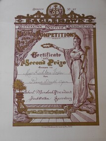 Bendigo Historical Society Inc.
Document - FOSTER AND WILSON COLLECTION: CERTIFICATE EAGLEHAWK AUSTRALIAN NATIVES ASSOCIATION, 1908
Certificate for Second Prize in Eaglehawk Australian Natives Association Musical and Elocutionary Competitions in 1908. Certificate is printed on cream coloured card with gold and red illustrations and writing. At the top is the crest of the Australian Natives Associaation with the words Branch and No 37 either side. The year 1908 and the words Eaglehawk and Australian Natives Association Musical and Elocutionary Competitions are printed within scrollwork below. A figure dressed in robes holding a laurel wreath and trumpet is standing on the right hand side. Certificate and Second Prize awarded to Miss Kathleen Foster for Piano Duet Open are printed and written below.Herbert Woodhouse lith, Law Courts Place Melbournedocument, certificate, music -
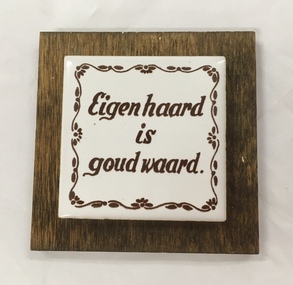 Dutch Australian Heritage Centre Victoria
Small framed tile
Eigen haard is goud waard. (There is no place like home) -
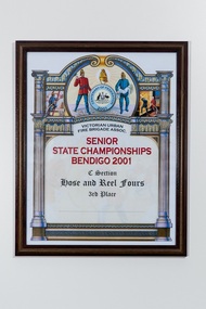 Wangaratta Urban Fire Brigaderectangle framed certificate for the 'senior state championships, Bendigo, 2001C section hose and reel fours 3rd place
 -
 Whitehorse Historical Society Inc.
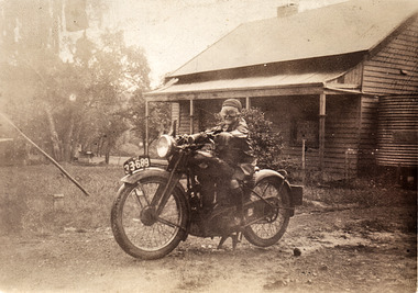
Photograph, William Sandilands, 1939
Faded sepia photograph of William Charles Sandilands on a motorbike in front of a wooden house with a tank at the right. William was the eighth child of Louisa Amelia Schwerkolt (1890-1966) and John Sandilands (1881-1958)Billy on motorbike outside grandmas place. (Francesca Schwerkolt)sandilands william, schwerkolt louis, schwerkolt francesca (both) -
 Ballarat Tramway Museum
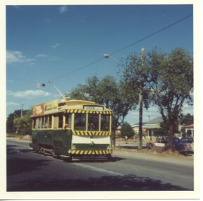
Photograph - Colour Photograph/s - set of 2, 5/03/1971 12:00:00 AM
Yields information the Victoria St terminus and the appearance of the Gardens in March 1971.Set of two colour prints: .1 - No. 33 at Victoria St terminus, 5/3/1971 .2 - view of the Botanic gardens with the statute of Wallace and the old hot house in the background. Date 5/3/71. Many colour garden beds in the photograph. Printed on Kodak paper.On the rear of the photograph is a stamp with date, place and subject details.trams, tramways, victoria st, gardens, botanical gardens, tram 33 -
 Bendigo Historical Society Inc.
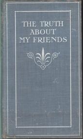
Book - BOOK: THE TRUTH ABOUT MY FRIENDS
BHS CollectionHardcover cloth bound book - blue cover with silver decorative border engraving and title. Small 'parlour game' book containing blank pages with a small printed pasted in slip with the words '' Now 'play the game', Don't peep beneath, First sign your name, Then lift the leaf''. Various self criticisms or truths are then revealed under the slip. Some pages have been signed, others are unsigned. Several pages have been removed. The name O M Chamberlain has been signed inside the front cover.Dow and Lester London Forresters Hall Place ECbook, bendigo, bendigo history & its people -
 City of Moorabbin Historical Society (Operating the Box Cottage Museum)
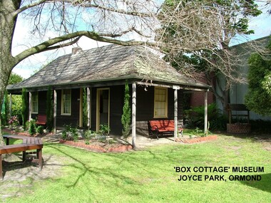
Photograph - ' Box Cottage' Reconstruction, c1841
The original small, pioneer cottage was built in the late 1840s to early1850s, by an unknown pioneer. It was located on part of a 30 Acre allotment that was originally part of Henry Dendy’s Special Survey granted in 1841. The doors and window sashes, (made of red deal joinery timber), as well as the brass locks and fittings, are from the original cottage, and were imported from England.The fire-place bricks are from the original cottage, and are sun-dried, (not kiln fired), and are hand-made. Convict marks can be seen on two bricks.There is a small display of external cladding shingles from the original pioneer cottage. These shingles were hand-split, and most likely made from locally collected timber The nails included in this display were used to fasten the shingles on the original cottage, and are also hand-made. The enamel nameplate, “Colonial”, on the wall of the cottage, was the name chosen for the original pioneer cottage when a later owner, Mr August Rietman and wife Frieda leased the property in around 1917. August purchased the property 1935 for 1200 Pounds approximately and resided there until 1953. In 1974 Mr Lewis, a timber specialist, found the dilapidated building on property he had recently purchased in Jasper Rd and suggested it be reconstructed and relocated. Moorabbin Council agreed and the Cottage was rebuilt just about 250 metres from its original site. The cost of the rebuild was met by 'Victoria's 150th Committee, plus a small grant from the City of Moorabbin, and Mr Laurie Lewis donated much of the timber for the reconstruction. Although 'Box Cottage' is a re-construction, it is an unique museum that, being located in the midst of a modern community in Ormond Victoria, can educate and demonstrate many aspects of the early settler’s way of life in Victoria. As such, it is an invaluable resource for students and all kinds of visitors. The original small, pioneer cottage was built in the late 1840s to1850s, by an unknown pioneer. It was located on part of a 30 Acre allotment that was originally part of Dendy’s Special Survey granted in 1841. The re-constructed pioneer cottage, named ‘Box Cottage’, is located only a matter of metres from the original pioneer cottage site, in Joyce Park, Jasper Road, Ormond, Victoria. The museum has copies of interesting Land Titles associated with the surrounding land, including the site of the original pioneer cottage, from Dendy’s time, and into the 1900s. ‘Box Cottage’ is named after the pioneers, William and Elizabeth Box, who resided in the original cottage from approximately 1865, until Elizabeth’s death in 1914.The re-constructed cottage plan has followed faithfully the original dimensions, and plan of the original pioneer cottage, and as many original items from that cottage’s long occupation have been incorporated. Convict marks on sun -dried, fire-place chimney bricks. Enamel nameplate 'Colonial' circa1915brighton, moorabbin, cottages, pioneers, ormond, colonial, mckinnon, dendy henry, box william, box elizabeth, convicts, rietman august, rietman frieda, rietman stefanie -
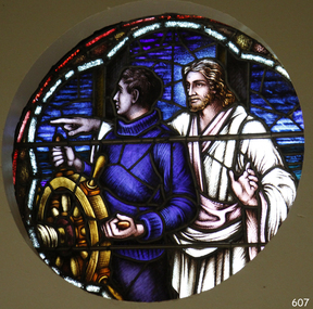 Flagstaff Hill Maritime Museum and Village
Artwork, other - Window, Brooks, Robinson & Co, Christ Showing the Helmsman the Way, circa August 1947
This round, stained glass window, titled "Christ Showing the Helmsman the Way", was installed in the St Nicholas Seamen's Church at 139 Nelson Place, Williamstown, Victoria. The window was referred to as the Sanctuary Window and was installed in the chapel above the altar. This memorial window has significance as a part of Victoria's War Heritage and is listed on the Victorian Heritage Database. The window was donated to St Nicholas Seamen’s Church as a memorial to the members of the Merchant Navy whose lives were lost in the Second World War, 1939-1945. The donor was the Williamstown Lightkeepers Auxiliary, an independent ladies association working with the Williamstown Missions to Seamen (the Missions to Seamen organisation was re-named the Mission to Seafarers in the year 2000). The window was officially dedicated on December 14, 1947 by Geelong's Anglican Bishop, Rt. Rev. J.D. McKie. In the early months of 1948 a bronze plaque was also placed in the chapel above the altar. It recognises the lost souls of the Merchant Navy during World War 2, as well as the donor of the window, the Williamstown Lightkeepers Auxiliary. The inscription impressed on the rectangular bronze plaque, 20.4 x 10.2cm, is as follows: “IN MEMORY OF THE MEMBERS OF THE MERCHANT NAVY WHO WERE LOST IN THE SECOND WORLD WAR 1939-1945 FAITHFUL UNTO DEATH. THE WINDOW ABOVE THE ALTAR WAS ERECTED BY THE WILLIAMSTOWN LIGHTKEEPERS AUXILIARY 1947.” The Williamstown St Nicholas Seamen’s Church ceased operation in 1966. In 1979 the Victoria Missions to Seamen donated this round, stained glass window and the memorial plaque to Flagstaff Hill Maritime Village, along with many other items and furnishings. These items have been used to simulate the Williamstown Mission and Chapel as much as possible. The round space that formerly displayed the window can still be seen at the back of the old St Nicholas Seamen’s Church, previously the ES&A bank, in Williamstown. THE MISSIONS TO SEAMEN (Brief History: for more, see our Reg. No. 611, Set of Pews) The Missions to Seamen, an Anglican charity, has served seafarers of the world since 1856 in Great Britain. It symbol is a Flying Angel, inspired by a Bible verse. Today there are centr4es in over 200 ports world-wide where seamen of all backgrounds are offered a warm welcome and provided with a wide range of facilities. In Victoria the orgainsation began in Williamstown in 1857. It was as a Sailors’ Church, also known as ‘Bethel’ or the ‘Floating Church’. Its location was an old hulk floating in Hobson’s Bay, Port of Melbourne. It soon became part of the Missions to Seamen, Victoria. In the year 2000 the organisation, now named Mission to Seafarers, still operated locally in Melbourne, Portland, Geelong and Hastings. The Ladies’ Harbour Lights Guild was formed in 1906 to support the Missions to Seamen in Melbourne and other centres such as Williamstown. Two of the most significant ladies of the Guild were founder Ethel Augusta Godfrey and foundation member Alice Sibthorpe Tracy (who established a branch of the Guild in Warrnambool in 1920). The Guild continued its work until the 1960s. In 1943 a former Williamstown bank was purchased for the Missions to Seaman Club. The chapel was named St Nicholas’ Seamen’s Church and was supported by the Ladies’ Harbour Lights Guild, the Williamstown Lightkeepers’ Auxiliary and the League of Soldiers’ and Sailors’ Friends. It ceased operation in 1966. A Missions to Seamen Chapel and Recreation Room was a significant feature of ports during the late 1800s and into the 1900s. It seemed appropriate for Flagstaff Hill to include such a representation within the new Maritime Village, so the Melbourne Board of Management of Missions to Seamen Victoria gave its permission on 21st May 1979 for the entire furnishings of the Williamstown chapel to be transferred to Flagstaff Hill. The St Nicholas Seamen’s Church was officially opened on October 11, 1981 and closely resembles the Williamstown chapel. This stained glass window is significant historically for its origin in the St Nicholas Mission to Seamen's Church in Williamstown, established in 1857 to cater for the physical, social, and spiritual needs of seafarers. It was donated to the Mission by the Lightkeepers Auxiliary (Ladies Harbour Lights Guild, which was formed in 1905). The Missions to Seamen organisation had its origins in Bristol, England when a Seamen's Mission was formed in 1837. The first Australian branch was started in 1856 by the Rev. Kerr Johnston, a Church of England clergyman, and operated from a hulk moored in Hobson’s Bay; later the Mission occupied buildings in Williamstown and Port Melbourne. The connection of this window the Mission to Seamen and the Ladies Harbour Lights Guild highlights the strong community awareness of the life of people at sea, their dangers and hardships, and their need for physical, financial, spiritual and moral support. This memorial window has significant as a part of Victoria's War Heritage and is listed on the Victorian Heritage Database, Heritage Number 196973.Window, stained glass, circular, with reinforcing bars. The window represents Christ showing the helmsman the way. It shows a man in blue knitted jumper holding onto a ship's wheel, looking over his right shoulder. Behind him stands a man in a white robe pointing to his right and looking to his left, his left hand gesturing to pause. The background has various shapes and patterns of blue glass, bordered by two arcs, the outer one is white, the inner one is red. This beautiful window is in our St Nicholas Seamen's Church Collection and was brought to Warrnambool from the original St Nicholas Seamen’s Church in Williamstown. flagstaff hill, warrnambool, shipwrecked coast, flagstaff hill maritime museum, maritime museum, shipwreck coast, flagstaff hill maritime village, great ocean road, mission to seamen williamstown, st nicholas seaman’s church williamstown, missions to seamen victoria, mission to seafarers, lightkeepers auxiliary, ladies harbour light guild, 139 nelson place williamstown, religion, religious service, sailors rest, bethel sailors’ church, bethel floating church, e. s. & a. bank williamstown, christ directing a sailor, christ showing the helmsman the way, quartermaster’s hand on the wheel, stained glass window, church window, religious window, sanctuary window, memorial window, war memorial window, victorian war heritage inventory, victorian heritage database, merchant navy ww2, 1939-1945, anglican church, bishop mckie, mrs musther, brooks robinson & co, flying angel club, williamstown lightkeepers' auxiliary, ladies' harbour lights guild, commemorative window -
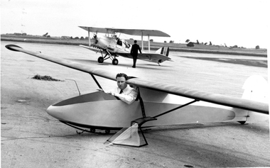 Australian Gliding Museum
Machine - Glider – Sailplane, 1955
The EP-1 "Spruce Goose" sailplane was designed and built by Ted Pascoe in 1955 as a smaller than average single seat sailplane that could be operated by two or three people. At times it was launched by auto-towing by Ted Pascoe and his wife without the aid of a third person at the wing tip. The glider exhibited good soaring capability and was used for some cross country flights. For instance, in 1956 Ted Pascoe succeeded in a 36 mile goal flight during which he attained a maximum height of 4500 feet. It was flown at the Mt Gambier Gliding Club from 1956 until about 1961. The Log Book shows that it was flown at Everard in 1961 and at Everard, Waikerie, Gawler and Keith in 1962. There is a gap in flying record for this aircraft from 1962 until 1967. From 1967 to 1972 it was flown regularly at various places in South Australia including Whitwarta, Stonefield, Renmark, and Gawler. For many years it was owned and flown by Mervyn Gill of the Balaklava Gliding Club.The EP-1 glider is an example of a successful Australian home built design from the 1950s. It was one of a small number of notable locally designed gliders of less than the usual 15 metre wing span from the 1950s and 1960s.Small, light weight, sailplane of wooden construction with fabric covering on wings (strutted), elevator and rudder. Instruments have been removed and control column is not in place. Serial Number GFA/HB/24 australian gliding, glider, sailplane, spruce goose, ep 1, ted pascoe, mt gambier gliding club, mervyn gill, balaklava gliding club -
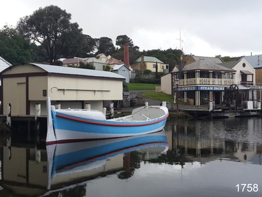 Flagstaff Hill Maritime Museum and Village
Vehicle - Vessel, Lifeboat Warrnambool, 01/09/1910
The construction of the lifeboat ‘Warrnambool’ began 15th September 1909 and was completed almost 12 months later, 1st September 1910. It was built at the Government Dockyard in Williamstown, Victoria, along the lines designed by the Great Britain’s Royal Lifeboat Institution, and included whaleback decks fore and aft, mast and centreboard, and rudder and tiller hung from the sternpost. It could be propelled by both sail and oar. At that time Captain Ferguson was Chief Harbour Master and Mr Beagley was foreman boat builder when he and his fellow workmen built the boat. The boat was described as “… a fine piece of workmanship and does credit to her builders and designers…” It had all the latest improvements in shape, disposition of weight and watertight compartments, and it had space for a large number of people in addition to the crew. It appears that 'H Meiers' whose signature, along with building dates, is pencilled on a concealed timber 'plaque' in the hull, was involved with the building of the lifeboat. It is interesting that the ‘Melbourne Directory’ of 1911, published by Sands and MacDougal, lists McAuley and Meiers, boat builders, Nelson Place foreshore, between Pasco and Parker Streets, Williamstown, (Victorian Heritage Database, ‘Contextual History, Maritime Facilities’), It is probably the company of the person whose name is inscribed on the lifeboat plaque. Flagstaff Hill’s documentation also mentions that the keel was laid at ‘Harry Myers, boat builders, Williamstown, Melbourne’ – the name ‘Myers’ can also be spelled ‘Meiers’, which could be the same person as the Meiers in “McAuley and Meiers” (as mentioned in genealogy lines of Myers). The new lifeboat, to be named ‘Warrnambool’ was brought to town by train and launched at the breakwater on 1st March 1911 using the Titan crane (the old lifeboat built in 1858, was then returned to Melbourne in 1911). This new lifeboat was stationed at Warrnambool in a shed located at the base of the Breakwater, adjacent to the slipway. A winch was used to bring it in and out of the water. The lifeboat ‘Warrnambool’ was similar in size to the old lifeboat but far superior in design, build and sea-going qualities such as greater manoeuvrability. The ‘self-righting, self-draining’ design was “practically non-capsizeable” and even if the boat overturned it would right itself to an even keel and the water would drain away. The hull was built of New Zealand Kauri, using double diagonal planking, laid in two layers at right angles, with a layer of canvas and red lead paint between the timbers to help seal the planking. It has “… plenty of freeboard, high watertight spaces between the deck and bottom… through which pipes lead…” The backbone timbers were made of Jarrah. The lifeboat Warrnambool was one of several rescue boats used at Port Fairy and Warrnambool in early 1900's. In late 1914 the Warrnambool lifeboat and crew were used to help find what was left of the tragic wreckage of the Antares, and were able to discover the body of one of the crewmen, which they brought back to Warrnambool. Between 1951 and 1954 the lifeboat was manned under the guidance of Captain Carrington. He held lifeboat practice each month on a Sunday morning, to comply with the Ports and Harbour’s request that lifeboats be manned by a strong and competent crew, ready for action in case of emergency. In the early 1960’s it ended its service as a lifeboat and was used in Port Fairy as a barge to help dredge the Moyne River, bolted to the Port Fairy lifeboat. Flagstaff Hill obtained the Warrnambool in 1975. In 1984 it was on display at Flagstaff Hill Maritime Village, Warrnambool. On 23rd May 1990 she was lifted from the water and placed in a cradle for restoration. The name ‘WARRNAMBOOL could be seen faintly on the lifeboat before it was restored. It was during the restoration that Flagstaff Hill's boat builder discovered the 'plaque' inside the hull. A copy of the blueprint plans has the name “V.E.E. Gotch” printed on it. His advertisement in Footscray’s ‘Independent’ newspaper of Saturday 11th May 1901 states he is “Principal and Skilled member (Naval Architect) to the Court of Marine Inquiry of Victoria and holds classes for naval architectural drawing and arithmetic.”The lifeboat WARRNAMBOOL is significant for its half century service to the local community as a lifesaving vessel. She was also used to help retrieve the body of a shipwrecked crew member of the ANTARES. Lifeboat "Warrnambool", a wooden, clinker hull, 'self-righting, self-draining design, single mast, pivoting centreboard. Complete with sail and yardarm. A 'plaque' was found inside the hull of the lifeboat, made of untreated wood, disc-shaped with one straight edge (Diam 15.5cm), inscribed by one of the boat builders in pencil script "Life Boat Start building / 15/9/09 - complete 1/9/10 / (signature looks like H Meiers) / Boat Builder)."'Plaque' inside body of boat is inscribed in pencil, script writing "Life Boat Start building / 15/9/09 - complete 1/9/10 / (signature looks like H Meiels) / Boat Builder)." flagstaff hill, warrnambool, shipwrecked-coast, flagstaff-hill, flagstaff-hill-maritime-museum, maritime-museum, shipwreck-coast, flagstaff-hill-maritime-village, lifeboat, life boat, vessel, life saving, 1910 vessel, port fairy, boat builder plaque, rescue boat, beagley, williamstown, government dockyard, v.e.e. gotch, royal lifeboat institution, captain ferguson, meiers, nelson place, non-capsizeable, self-righting, titan crane, double diagonal planking, captain carrington, barge, antares, self righting, crew of twelve, capacity of 30 survivors -
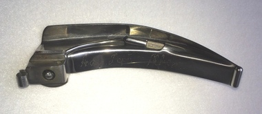 Geoffrey Kaye Museum of Anaesthetic History
Blade, Laryngoscope, BOC
A curved laryngoscope blade with bulb only. Its has an engraved detail about the place it belonged. Also, it has stamped on the blade the maker's seal and its material. At the base of the blade is stamped the place where it was made. The top of the blade has some scratches and the base has an oxide spot over the name of the place it was made. Engraved on the blade, Anaes. Dept. Alfred Stamped on the base of the blade, MADE IN ENGLAND Stamped on the blade left side, STAINLESS Stamped on the blade on top of the base a circular seal with the letters, BOC laryngoscope, light bulb, glass, blade, boc, british oxygen company