Showing 6613 items
matching rivers
-
 Robin Boyd Foundation
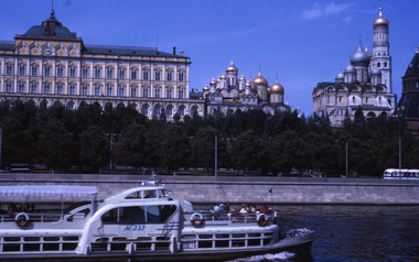
Slide, Robin Boyd, 1964
In 1964, Robin and Patricia Boyd spent several weeks on a world tour - Boyd took a leading role at the International Design Conference in Aspen and he also visited Chicago, Yale University, and New York’s World Fair. The Boyds then travelled on to England, Finland (especially to see Tapiola), Russia and India to see Le Corbusier's Chandigarh, and also Hong Kong and Thailand.Colour slide in a mount. Moscow Kremlin administrative building and Orthodox churches looking from Moscow River, Moscow, RussiaMade in Australia / 14 / AUG 64Mrussia, slide -
 Robin Boyd Foundation
Slide, Robin Boyd, 1967
Colour slide in a mount. Possibly Yarra river across to Richmond from Alexandra Avenue, South Yarra, Victoria, AustraliaMade in Australia / 30 / JUN 67M6 / Encircled 48 (Handwritten)slide, robin boyd -
 Hume City Civic Collection
Photograph
Two men are standing on the swing bridge which was constructed across Deep Creek at Bulla. The river and opposite riverbank are in the foreground.bulla, deep creek, bridges, swing bridge, george evans collection -
 Hume City Civic Collection
Photograph
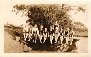
The area near the 'Nook' was used as a swimming pool by Sunbury residents before the swimming centre was built in Ligar Street, Sunbury. Sunbury Swimming Pool - written on the back.A snap shot of 11 people (unidentified) sitting on the bank of a river. There are two men and 9 children of varying ages in the photo.swimming, sports, jackson's creek, clothing and dress, recreation, swimming pools, sunbury swimming pool, george evans collection -
 Lakes Entrance Regional Historical Society (operating as Lakes Entrance History Centre & Museum)
Book, Synan Peter, Secrets of Ghost Towns of the High Country featuring 50 Ghost Towns in and around Victorias Alpine Region, 1989
A history of the Gippsland Lakes Victoria as a transport system v for trade within the Lakes and River systems and coastal and interstate trade.ships and shipping, land settlement, waterways -
Lakes Entrance Regional Historical Society (operating as Lakes Entrance History Centre & Museum)
Photograph, Myrtle Olive Fish, 1/09/1933 12:00:00 AM
Also a second photograph taken from a slightly different angle 05195 6.5 x 9 cmBlack and white photograph of view of Buchan with bridge over Buchan River in foreground with butter factory behind and various buildingstopography -
 Rutherglen Historical Society
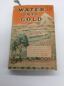
Book, Robertson & Mullens, Water Into Gold, 1946
From the estate of Florence Iggsten.Book with orange cloth cover with black writing. Dust cover printed in shades of orange and green with view of river and fields.On inside page opposite first title - "Mrs Iggsten Xmas 1946"renmark, dried fruit, murray river, mildura, agriculture, irrigation -
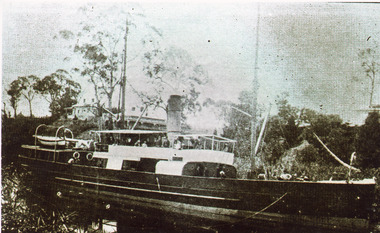 Lakes Entrance Regional Historical Society (operating as Lakes Entrance History Centre & Museum)
Photograph, 1899
Black and white photograph showing SS Glenelg in Mitchell River. House on bank, vegetation, crowd on ship. Bairnsdale VictoriaThe S.S. Glenelgjetties, ships and shipping, waterways -
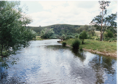 Lakes Entrance Regional Historical Society (operating as Lakes Entrance History Centre & Museum)
Photograph, Tambo Shire, 1994 c
Also second identical copyColour photograph of the Buchan river, showing stream flowing between low banks, hills rising in distance. Buchan Victoriaagriculture, topography -
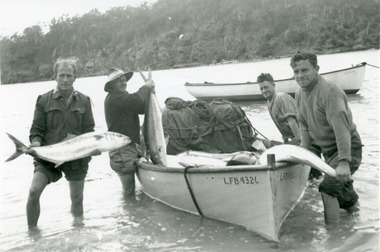 Lakes Entrance Regional Historical Society (operating as Lakes Entrance History Centre & Museum)
Photograph, 1950c
Black and white photograph of four men showing their catch of king fish from their lake boat in the Pambula River, NSWfishing industry, boats and boating, fish, jetties -
 Hume City Civic Collection
Photograph, The Nook, c1940
The Nook in Sunbury is situated on a wide and deep bend in Jacksons Creek. Today the area is a popular site for passive recreation with a walking path along the Jacksons Creek. The house on the RHS of the photograph was situated near Powlett Street.Before the Aquatic Centre was built in Sunbury the swimming pool at The Nook was the town's swimming pool for many years. Seats and a change area were at the site.A black and white photograph of a large bend in a river with a house built on its riverbank and another dwelling on the hillside in the middle distance.the nook, swimming, jacksons creek -
Lakes Entrance Regional Historical Society (operating as Lakes Entrance History Centre & Museum)
Photograph, Caire, Nicholas John, 1905c
Latrobe Bridge from the Glengarry. This bridge spans the Latrobe at the junction of the Glengarry and the Thompson.Black and white photograph of the Latrobe Bridge,in the closed position, taken from the bank of the Glengarry Latrobe River. Sale Victoriawaterways, bridges, civil engineering -
Lakes Entrance Regional Historical Society (operating as Lakes Entrance History Centre & Museum)
Photograph, M Holding, 1999
Colour photograph of Johnsonville jetty boat ramp and parking area before installation of new jetty on Tambo River Johnsonvillehouses -
 Otway Districts Historical Society
Photograph, Knox Collection, Railway Bridge over Gellibrand River, 1902
Railway bridge over the Gellibrand River, 1902. Note the people on the roadway bridge in the top left corner. B/W.colac; beech forest; gellibrand; railway; -
Moorabbin Air Museum
Book - OSPREY AIRCRAFT OF THE ACES 56 LaGG & Lavochkin Aces of World War 2, 2003
OSPREY AIRCRAFT OF THE ACES 56 LaGG & Lavochkin Aces of World War 2Front cover showing close up of a Lavochkin La-7 downing a German Jet, river below, grey skynon-fictionOSPREY AIRCRAFT OF THE ACES 56 LaGG & Lavochkin Aces of World War 2 -
 City of Warrnambool Rowing Club
Photograph
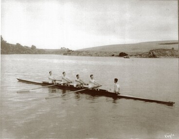
The photograph is of the 1925 Warrnambool Rowing Club Lightweight four- they raced at the clubs annual Boxing Day Regatta. H Sherriff was stroke J MacNamara (3 seat) C Earls (2 seat) L Halliwell (bow), T Fary was cox. The Regatta that year had three events and the other usual aquatic events were cancelled due to poor weather. Mr W. A. Hope was regatta secretary. It is recorded on page 109 of the 1914-35 minute book that 'Mr. Meckin, the president, said he had much pleasure in moving a motion of long salutation to the light weight four in recognition of the fine performance they put in at the Yarra Yarra and Albert Park Regattas...Mr. Hope seconded and added...credit to the crew..a fine lesson to some of the older members in perseverance..'Black and white photograph of a Warrnambool Rowing Club crew of 5 in a rowing boat on the Hopkins River, Warrnambool. Taken in 1925. Under the photograph is the name of the crew and year it was taken: Lightweight fours 1925 H Sherriff stroke J MacNamara C Earls L Halliwell bow T Fary coxrowing, warrnambool rowing club, hopkins river, city of warrnambool rowing club -
 Sunbury Family History and Heritage Society Inc.
Photograph
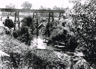
The photograph shows a section go the Jacksons Creek at Sunbury where it is spanned by the high arched Rupertswood railway bridge north of the town on the Bendigo line. The Melbourne to Bendigo rail line has a number of significant bridges along its route, five of which can be seen in Sunbury.A sepia photograph in post card format of a river flowing under a bridge. There is a partial view of the tall pylon on the LHS of the image.jacksons creek, bridges -
University of Melbourne, Burnley Campus Archives
Plan, The Heyington Diversion
yarra, river, freeway -
 St Patrick's Old Collegians Association (SPOCA)
Photograph - Students, 1920s
-
 Linton Mechanics Institute and Free Library Collection
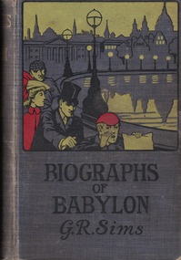
Book - Novel, Sims, George R, Biographs of Babylon by George R. Sims, 1902
A collection of stories.Hardcover book with a grey cover. A colour image of three men and a woman along the bank of a river on cover. 240 pages.fictionA collection of stories.george r. sims, fiction -
 Bendigo Historical Society Inc.
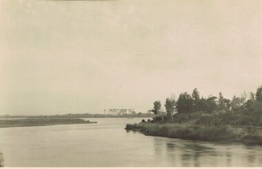
Postcard - ACC LOCK COLLECTION: B&W PHOTO OF A RIVER, EGYPT, POSTCARD, 1914-1918
Poastcard, WW1, B&W photo of one of the river Nile tributaries. Trees on the right side bank and palm trees in the distance beyond a small craft on the river. Handwritten in ink on the back - North of one of the tributaries of the Nile. Egypt Dec '15 Also handwritten in pencil - more of right side to appearpostcard, postcard, ww1, egypt, river nile -
 Kew Historical Society Inc
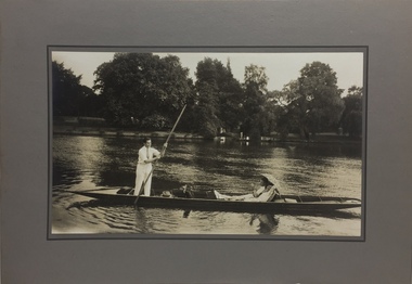
Photograph - John Duncan Brownlee and friends, Yarra River, The Artorium, 1920s
This mounted and framed photograph of a group of friends punting on the River Yarra has a number of historic and artistic associations. The photograph is primarily important as an informal photograph of the Australian baritone John Donald Mackenzie Brownlee (1900-1969), whose international career at the world's major opera houses from 1927 until his retirement in 1958 included singing at Melba's Covent Garden farewell in 1926, to recordings in the 1930s of a major series of Mozart operas in Glyndebourne Festival productions, conducted by Fritz Busch. Brownlee, born in Geelong, won the gold medal as champion vocalist at the South Street competitions in Ballarat in 1921. Moving to Paris in 1923 he began study with the French baritone, Dinh Gilly, making his operatic debut at the Trianon Lyrique in Montmartre in 1926. The most significant periods of his operatic career were with the Paris Opera from 1927 to 1936, and at the Metropolitan Opera from 1937 to 1957. After his move to Paris in 1923, he is recorded as revisiting Australia in 1928 as a member of the Melba-Williamson Company, and 24 years later in 1952. The photograph of Brownlee and the Gardners in a punt on the Yarra, while putatively dated to 1925, must be from earlier in the 1920s before his move to Paris, or later during the Melba-Williamson Company season. Before his move to Paris in 1923, Brownlee had lived in Belmont Avenue, Kew, where he must have developed a friendship with the Gardners. The photograph has additional artistic significance as it was produced at 'The Artorium', James Beament's design studio next to the Hawthorn Town Hall at 362 Burwood Road. With a home at 33 Uvadale Road (designed by Eric Nicholls, who managed the architectural practice of Walter Burley and Marion Mahony Grifffin from 1924 to 1932), Beament painted a number of significant murals for the Griffin practice, including those at the Capitol Theatre in Melbourne.A photograph of recreational activities on the River Yarra. The photograph is historically significant as a professionally produced photograph of the Australian operatic baritone John Brownlee, either before his move to Paris in 1923, or in 1928 during the Melba-Williamson Company operatic tour of Australia. The photograph has additional aesthetic significance as it was produced in James Beament's Hawthorn Studio - The Artorium - at 362 Burwood Road, next to the Hawthorn Town Hall.Framed photograph of John Duncan Brownlee, the Australian tenor, with Enid Gardner and friend in a punt on the Yarra River. Brownlee was born in Geelong but before his move to Paris in 1923, he lived for a period in Belmont Avenue, Kew. Three labels on reverse. 1. "John Duncan Brownlee, Operatic Star, originally of Geelong later resident of Kew at Belmont Av, on the pole. Also in the punt - Edith Gardner a friend. The Gardners lived on the east corner of Edgevale Rd. & Cotham. Approx. 1925." 2. "This picture is the property of Kew Historical Society 1/4/79". 3. Tel. Hawthorn 842 THE ARTORIUM ...."john brownlee (tenor), punting, recreation - yarra river (kew), james beament, the artorium -- 362 burwood road -- hawthorn (vic.) -
 Orbost & District Historical Society
newspaper clippings
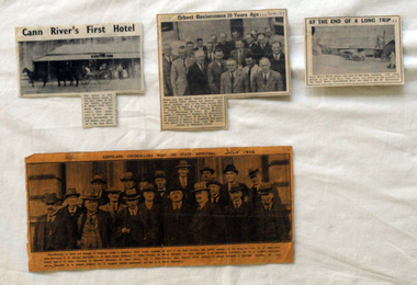
This collection of articles was collated by Mary Gilbert. 743.1 - In the group are, from left to right:—First Row—Councillors T. W. Murphy (Bairnsdale), J. R. Coate (Lakes Entrance); T. Hodgd (Tambo), W. Wilson (Berwick), A. Inglis (Mirboo), E. S. Whittakers (Traralgon), and W. C. Kingston (Warragul). Second Row—J. S. Lister (Rosedale), R. Stockdale (Narracan), W. Grose (Omeo), and J. Allan (Toora). Back Row—S. Purdy (Maffra), E. Heesom (Morwell), J. Arohibald (Bruthen), Mr. Lind, M.L.A., Councillor A. E. Rodwell (Orbost), Mr. S. Langslow (Health department), and Mr. C. S. Ogllvy (Warragul). A manila folder of newspaper cuttings related to commerce and government in Orbost. 743.1 is titled, " Gippsland Councillors Wait on State Ministers and is from The Argus, July 1926 .It has a large black / white photograph of the representatives of shires and boroughs of Gippsland who formed a deputation to meet which waited most of the State Ministers with various requests. 743.4 is from the Snowy River Mail and is titled, "Cann RIver's first Hotel" and has a black and white photograph of a four-wheeled buggy pulled by four horses standing outside a hotel. 743.5 is titled "At the End of a Long Trip" and is from the Snowy River Mai. It has a black and white photograph of the Cann River hotel with Mr W. Dreverman standing outside. 743.6 is from the Snowy River Mail, September 6, 1967, and is titled, " Orbosr Businessmen 20 Years Ago" and has a black and white photograph of a group of men in business suits.orbost-business cann-river-hotel -
 Wodonga & District Historical Society Inc
Album - Hume Reservoir Australia Album - View from the Victorian bank of the Murray River, May 1923, 1927
This set of photos is from a leather bound album bearing the inscription "HUME RESERVOIR AUSTRALIA" plus 'The Rt. Hon. L. C. M. S. Amery, P. C., M .P.' all inscribed in gold. It was presented to The Rt. Hon. L. C. M. S. Amery, P. C., M. P, Secretary of State for Dominion Affairs on the occasion of his visit to the Hume Reservoir on 2nd November 1927. This album is of local and national significance as it documents the planning and development of the Hume Reservoir up to 1927. It was the largest water reservoir in the British Empire. The album records the pioneering engineering work that went into its construction.DEPARTMENT OF PUBLIC WORKS, N.S.W. RIVER MURRAY WATERS SCHEME. HUME RESERVOIR. 12. View from the Victorian bank of the river showing in the foreground a levee bank along the New South Wales side of the river with connecting wings back to the higher ground, May 1923. The first stage in the construction of the Dam foundations was carried out inside the levee bank which was at a sufficient height to protect from floods the work going on inside. A length of 300 feet of the Dam was left at a low elevation to allow of the river flowing over it in the second stage of the operations and at the ends of the concrete was brought up above flood level. To divert the river, a Coffer Dam was built across the old bed above and below the Dam site and tying into the end of the concrete wall built inside the levee bank. This completely surrounded the remainder of the site of the Dam and south wing wall, including an area of 12½ acres.hume reservoir australia, river murray waters scheme, hume reservoir construction -
 Bendigo Historical Society Inc.
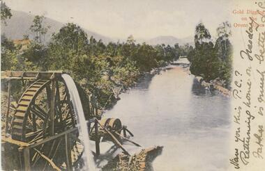
Postcard - GLADYS DEAN COLLECTION: POSTCARD, 1906 - 1908
Coloured photographic postcard with a 2cm white border on right hand side depicting gold digging on the Ovens River. Aspect is taken from behind a waterwheel with a man standing on a platform looking over the river. The banks are thickly treed and mountains can be seen in the distance. The words Gold Digging on the Ovens River are printed in red on the margin and handwritten in black are the words Have you this PC? Returning home on Tuesday Father is much better L.C. On the reverse card is addressed to Miss R Dean 'Esmond" Golden Square Bendigo.44140postcard -
 Kew Historical Society Inc
Photograph - Macauley's, Kew, 1924
Henry Beater Christian (1886-1962) , was a descendant of one of the earliest settler families in Kew. Employed at the Kew Asylum as a 'public servant', he was a skilled amateur photographer, photographing numerous scenes in Kew and on his travels around Victoria. The majority of his photographs date from 1916 to 1929. His finest photographs are housed in two photograph albums. A very rare, early panoramic view of Macauley's boat house on the Yarra River at Kew.Digital copy of a photograph from page 2 of the 47-page photograph album containing 261 gelatinous silver images, loaned by Diane Washfold with permission given to digitise and hold a copy in our collection. The photograph is of Macauley's boat sheds on the Yarra River at Kew. The boat sheds was located at the west end of Molesworth Street. The photograph is taken from the Yarra Bend Park side of the river looking down on the boat house from above. The canoes belonging to Macauley's are lined up on the river bank. "Macauley’s Kew"henry beater christian (1886-1962), landscape photography, kew (vic.) — yarra river, christian-washfold collection, photograph albums, macauley's boat sheds -
City of Kingston
Photograph - Colour, 29 January 1993
Bonbeach, Carrum and Patterson Lakes are suburbs in the City of Kingston. Bonbeach and Carrum were holiday destinations in early 20th century and over time the housing has converted to permanent residential structures. In Patterson Lakes, the area consists predominantly of newer housing developments and the tidal canal system which is accessible to many dwellings joins Port Phillip Bay.Bonbeach, Carrum and Patterson Lakes were previously part of the extensive Carrum Carrum Swamp. The area was once a source of fish and eels for the Mayone-Bulluk clan of the Bunurong people. Over time the area was drained and this allowed farming at Carrum and Bonbeach, although the area was prone to flooding. In the early 1920s and 30s the land was converted to residential dwellings. In 1973 investigations commenced nearby to Bonbeach and Carrum into the development of a unique residential area comprising canals and waterways. It was originally proposed to be known as "Gladesville". Circa 1974, the area was rezoned from rural to residential and named Patterson Lakes. Development has been continuous since the 1970s with staged construction of the waterways, residential housing, and supporting infrastructure and facilities.Laminated colour aerial photograph of the Bonbeach, Carrum and Patterson Lakes region within City of Kingston. This 1993 image includes Bonbeach High School prior to demolition, Bonbeach Primary School and Patterson River Golf Club. Sections of Patterson Lakes are not yet developed, including Rhode and Staten Islands. Long Island Point appears to be a recent development with many spare blocks and new houses under construction. The Patterson River marina is prominent and the river mouth as it meets Port Phillip Bay. The Carrum railway station is visible.Black type on white adhesive sticker: No. 6661 Black type on white adhesive sticker: 26E/6661, 29/1/93, 4.25 pm Black type on white adhesive sticker 29-1-93 Yellow circular adhesive stickerbonbeach, carrum, patterson lakes, patterson river, carrum carrum swamp, canals and waterways -
 Bendigo Military Museum
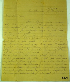
Letter, 22.7.1918
The letter is from Horace (Swag) LONG to Trixie who in other correspondence is called "Beat". Refer 11.4, 12.3. Horace LONG No 437, 9th & 4th LH Regt AIF. Refer Cat No 16P for his service details..1) - .3) Three pages of hand written letter on yellowed ruled paper..1) Top right: 22.7.18 Some where along the River Jordan. .3) From Swag the Dag.documents, letters, correspondence -
 Orbost & District Historical Society
book / colection, early 19th century
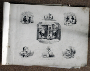
George Cruikshank (27 September 1792 – 1 February 1878) was a British caricaturist and book illustrator.. His book illustrations for his friend Charles Dickens, and many other authors, reached an international audience. George Cruikshank was inventive. In the 1800's, puns and other forms of word-play were loved by all. Some of these illustrations come from his 'Scraps and Sketches' album, published for adults in 1832, though the drawings were done between 1828 and 1832. Volumes of George Cruikshank's Scraps and Sketches were intended to be cut and pasted in home-made albums and scrapbooks; George Cruikshank was a well-known British caricaturist and book illustrator. This item represents this popular art form of the early to mid 19th century.A collection of artworks (copies of etchings) of George Cruikshank. They are bound together with masking tape. The pages are dated 1828-1823. They are satirical cartoons printed in black ink.on front : "V BROOME with CANN RIVER crossed through ORBOST 78 PERRY ST 5154 2855" -
![The Fairfield Bridge [circa 1891]](/media/collectors/550653872162f11fb04854aa/items/579eab98d0cdd117c4af1c89/item-media/579eac23d0cdd117c4afb1ad/item-fit-380x285.jpg) Kew Historical Society Inc
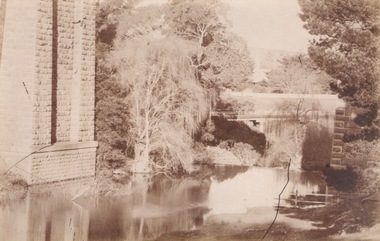
Kew Historical Society IncPrint, The Fairfield Bridge [circa 1891], c. 1891
This work forms part of the collection assembled by the historian Dorothy Rogers, that was donated to the Kew Historical Society by her son John Rogers in 2015. The manuscripts, photographs, maps, and documents were sourced by her from both family and local collections or produced as references for her print publications. Many were directly used by Rogers in writing ‘Lovely Old Homes of Kew’ (1961) and 'A History of Kew' (1973), or the numerous articles on local history that she produced for suburban newspapers. Most of the photographs in the collection include detailed annotations in her hand. The Rogers Collection provides a comprehensive insight into the working habits of a historian in the 1960s and 1970s. Together it forms the largest privately-donated collection within the archives of the Kew Historical Society.A reproduction of a photograph of the Fairfield Bridge. The bridge was one of the first constructed for the Outer Circle Railway in 1891. Its supervising engineer was [Sir] John Monash. The bridge was later to be repurposed as a road linking the Chandler Highway to Fairfield."Outer Circle Railway Bridge over River Yarra at Fairfield (last section of line opened 1891)"fairfield bridge, chandler highway bridge, dorothy rogers, john monash, outer circle railway