Showing 32207 items matching "a building"
-
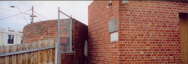
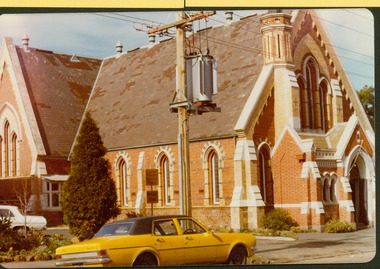
 Mission to Seafarers Victoria
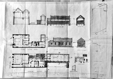
Plan, Arthur Peck, Victorian Missions to Seaman - Reconstruction of 139 Nelson Place, Williamstown and Erection of chapel, July 1943
After the closure of the Institute (former skating rink) on Thompson St, the Mission, thanks to the Williamstown Lightkeepers Auxiliaire and funds donated the High Commissioner of Canada, the former E,S & B Bank on Nelson Place was purchased and renovated. The St Nicholas chapel was added at the back of the building. Architects Arthur Peck and his eldest son, Hugh, were commissionned for the design. Arthur Peck was himself a keen yachstman. He died in 1945 at the age of 90.Large photocopie of original plans for the renovation of the E,S & B Bank building in Williamstown with the addition of the St Nicholas chapel.williamstown, williamstown lightkeepers auxiliary, arthur peck, hugh l. peck, st nicholas chapel -
 Surrey Hills Historical Society Collection
Photograph - Mont Albert Primary School, 1926
This was reproduced from a copy of the 1926 flyer relating to the Annual Speech Night. See vertical file re Mont Albert Primary / Mont Albert Central School. It was reproduced with the consent of the school archives in the early 1980's by Kenneth Tudor Hall. Mont Albert Primary was built in 1917 and was designated as a Central School in 1918 when Forms 1 & 2 were added. It remained as such until the 1964 when the secondary years formed the basis of a new high school, known as the Box Hill North High School, (later changed to Koonung Secondary College). The original building was constructed of solid red brick and consisted of seven rooms. In May 1924 a further four rooms, also in red brick, were added. The school opened with an initial enrolment of 147 students in Prep to Grade 6. A further 72 children were admitted during the year, making a total enrolment in the first year of 219. The land facing Kenmare Street was purchased in 1919, adding another 2 acres to the 5.5 acres which the school occupied in 1917. The first Principal was Charles Hyland, who was assisted by three teachers. The first official meeting of the School Council in May 1917 reveals that the building was in some senses a shell, requiring additional input from parents. Mention is made of the need for asphalting of playing areas, providing a letter box and electric lights for the lobby, double room, office and sewing room. Mont Albert was the first School in Victoria to have the interior purely constructed of Victoria hardwood, from floor to ceiling. An Honour Board was erected in 1919. mont albert central school, mont albert primary school, mont albert, schools -
 Federation University Historical Collection
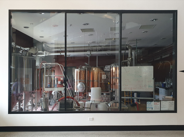
Photograph, Clare Gervasoni, Federation University Brewery (Y Building), 15/12/2021
Colour photograph of brewing equipment in the Mount Helen Coates Building (formerly the Union Building). The equipment was moved to Y Building after it was constructed. brewery, university of ballarat, coates building, union building, mt helen campus, brewing -
 Federation University Historical Collection
Photograph, University of Ballarat Brewery (Union Building)
Colour photograph of brewing equipment in the Mount Helen Coates Building (formerly the Union Building). The equipment was moved to Y Building after it was constructed. brewery, university of ballarat, coates building, union building, mt helen campus, brewing -
 Halls Gap & Grampians Historical Society
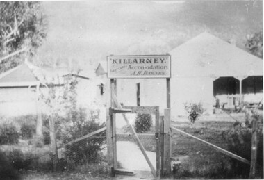
Photograph - B/W, C 1918
Kept by A H Barnes, 1922-1924 name changed to Grampians House kept by Miss Allison and Miss Porter 1924-1925 kept by Mrs Anderson Grampians House - The earliest record of Grampians House was recorded in 1918 when the property was known as "Killarney" listed in the Country, Hotel and Boarding House Guide and Tourists handbook. The listing notes it as being kept my Mr A H Barnes The property consisted of 29 acres, the house of 8 rooms, kitchen, bathroom, vestibule, front and side passages, with verandah on front and side of building, also 3 roomed cottage with bathroom, 5 chalets containing 7 bedrooms, storeroom,wash house, water and gas laid on throughout. 4 stall stables and feed house, buggy shed for three buggies, motor shed for 4 cars, cow shed, and yards and pens. Local resident Mrs E Watson who attended school in the nearby public hall remembers going to a side window of the house and being able to purchase biscuits, sweets and drinks. The 1922-24 Handbook the listing was changed to "Grampians House" kept by Misses Allison and Porter. The 1924-25 Handbook listed "Grampians House" being kept by Mrs Anderson.Photo of original building of 8 rooms Proprietor A H BarnesFuji Film Pictor Paperaccommodation, guesthouses, killarney, grampian hosue -
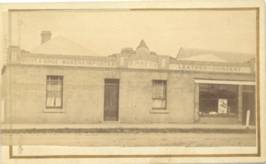 Bacchus Marsh & District Historical Society
Photograph, William Watts Boot and Shoemaker Shop Main Street Bacchus Marsh 1883
William Watts arrived in Bacchus Marsh in 1862 and for many years conducted a boot and shoe makers business in Main Street. This building, known as ‘Kentbury’ was built about 1858, and was formerly the premises of Bastings, cordwainer. The premises were enlarged in 1876 and occupied by Weaver. The building was demolished c.1960. Small sepia unframed photograph on card with gold border framing photograph. Housed in the album, 'Photographs of Bacchus Marsh and District in 1883 by Stevenson and McNicoll'. The image depicts the frontage of a boot and shoe makers premises.Signage on the upper part of the building reads 'Boot and Shoe Maker - Importer - Watts - Leather - Grindery'. The left hand side of the building appears to be a domestic dwelling, with a central door and two windows, one on either side. To the right there is a large shop display window and door. Both doors open directly onto the footpath. A post, probably a hitching post, stands on the footpath.On the front: Stevenson & McNicoll. Photo. 108 Elizabeth St. Melbourne. COPIES CAN BE OBTAINED AT ANY TIME. On the back: LIGHT & TRUTH inscribed on a banner surmounted by a representation of the rising sun. Copies of this Portrait can be had at any time by sending the Name and Post Office Money Order or Stamps for the amount of order to STEVENSON & McNICOLL LATE BENSON & STEVENSON, Photographers. 108 Elizabeth Street, MELBOURNE. stevenson and mcnicoll 1883 photographs of bacchus marsh and district, boot makers, shoe shops -
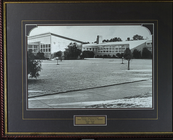 Federation University Historical Collection
Photograph - Framed photograph, Ballarat Teachers' College Gillies Street
These images were hung in the corridor of the University of Ballarat School of Education (Mount Helen). It most probably dates from around the time of the transfer of the College. The Ballarat Teachers' College was established after the Victorian State Government and the State Education Department decided to establish two provincial teachers' colleges, at Ballarat and Bendigo. On 04 May 1926 W.H. Ellwood (Principal), Miss A. Bouchier, and Mr A.B. Jones, welcomed the first enrolment of 61 students to undertake the one year course. In 1927 the College moved to the former Ballarat East Town Hall in Barkly Street, which was remodelled for their use. It closed in December 1931 due to the Great Depression. In 1946 Ballarat Teachers' College reopened and relocated to the Dana Street State School. The building used by the Teachers' College was the original bluestone building facing Doveton Street South. It was originally planned to open as a women's college, for whom the residence at 130 Victoria Street was purchased, but the decision was made to admit resident men from Ballarat. Mr T.W. Turner was appointed as Principal in 1951 and directed the introduction of a two year course for the Trained Primary Teachers' Certificate. The former one year course was terminated at the end of 1951. In 1958 the College was relocated to a custom built facility at Gillies Street, in close proximity to the Ballarat Botanical Gardens. Numbers increased with the introduction of the Trained Infant Teachers' Certificate course under the guidance of Mary Egan. With the introduction of a three year Diploma Course in 1968 accommodation became cramped. The introduction of the Diploma of Teaching (Primary) led to the Trained Infant Teachers' Certificate being discontinued in 1969, and the end of the Trained Primary Teachers' Certificate in 1969. Secondary Art and Craft students began studies at Ballarat Teachers' College in 1969 under Mr Ted Doney. In 1971 Mr D. Watson was appointed Principal. The State College of Victoria was proclaimed by Order in Council on 24 July 1973, and Ballarat Teachers' College became a constituent college of the State College of Victoria, and was known as State College of Victoria, Ballarat. By 1975 the College moved to Mount Helen as part of the Ballarat College of Advanced Education. Pre service teachers currently undertake their studies on the Mount Helen Campus of Federation University. ("Ruffians Attempted to Carry of the School Tent: A History of State Education in Ballarat", 1974, p73-4.) This image was hung in the corridor of the University of Ballarat School of Education (Mount Helen). It most probably dates from around the time of the transfer of the Ballarat Teachers' College from Gillies Street to the Mount Helen Campus of the Ballarat College of Advanced Educaiton. The building used by the Teachers' College was the original bluestone building facing Doveton Street South.Framed black and white photography with green mount. The photo shows the Ballarat Teachers' College Gillies Street building. ON plaque 'Ballarat Teachers' College, State College of Victoria at Ballarat, Gillies Street, 1958-1976education, ballarat teachers college, gillies street, 00607 -
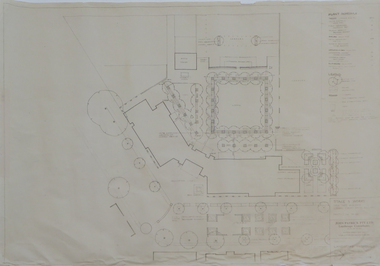 Federation University Historical Collection
Plan - Plans, Ballarat School of Mines Brewery Building Plans, 1995, 1995
The Ballarat School of Mines Brewery Building is now a part of the Ballarat Technology Park.Site plan and landscape plan for Stage 3 works for the Ballarat School of Mines Brewery Building. .1) Site plan by Philip Cox Sanderson & Partners, Melbourne .2) Landscape plan by John Patrick Pty Ltd, Landscape consultants, Kew, Victoriaballarat school of mines, brewery building, ballarat technology park, john patrick, philip cox sanderson, landscaping, archtectural plans -
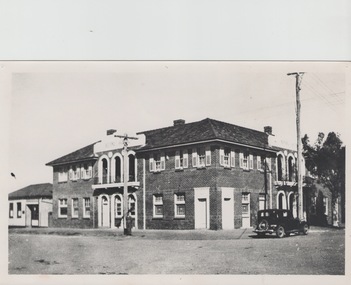 Sunbury Family History and Heritage Society Inc.
Photograph, The Royal Hotel, c1939
The two storey building is the Royal Hotel which is sited on the corner of Brook and Evans Streets in Sunbury's main shopping strip.The photograph was taken sometime in 1939 after it was totally rebuilt. A fire had damaged the old single storey structure, which was built on the same site c1860 shortly after Sunbury had a rail service. The building still operates today on the same site.The Royal Hotel is one of four hotels that were built in Evans Street Sunbury between Brook and Station Streets ion the 1860s shortly after the rail service arrived in the town. They were They were the Railway Hotel (Olive Tree), White Horse Hotel, Royal Hotel and the Rupertswood Hotel, opposite the Royal Hotel. A non-digital black and white photograph with a cream border of a two storey brick hotel building with light concrete trimming around the windows and entrances sited on a corner. A large black sedan car is parked near the corner. royal hotel, hotels -
 Federation University Historical Collection
Photograph, 4 Photographs of Painting of old Gaol Building
Old Gaol building is apart of the School of Mines Campus of Federation UniversityFour photographs of painters painting the old Gaol Building .1 3 painters in different positions doing painting .2 2 painters one on ladder painting around window .3 2 painters one standing on the fence .4 4 painters painting.painters, gaol building, school of mines ballarat, federation university, painting, painting gaol building -
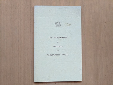 Robin Boyd Foundation
Booklet, Clerk of the Parliaments, The Parliament of Victoria and Parliament House, 1967
BookletOne small card, printed drawing on front of the Parliament House building: Herbert Moore, 'State Parliament House, Melbourne Victoria Aust'. Printed text on back about the building's history.walsh st library -
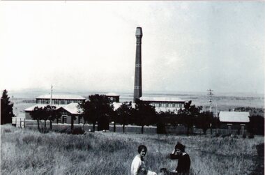 Sunbury Family History and Heritage Society Inc.
Photograph, Sunbury Asylum Boiler House, C 1920s
The building in the photograph is the Boiler House which was part of the former Sunbury Asylum. It was built in the 1920s to replace an older boiler. Coal and/or briquettes were burned to produce hot water and steam which was used to heat and supply hot water for the Asylum buildings. Steam attendants monitored and maintained the furnace and boiler seven days a week. It ceased production in October 1992 and since then has served as an Arts and Cultural complex for the local community. A non-digital black and white photograph of a large brick building with a tall chimney overlooking open rural countryside with two women sitting on the grass in the foreground. The image has been photographed from an earlier photograph. sunbury asylum, boiler house, arts and cultural complex, performing arts -
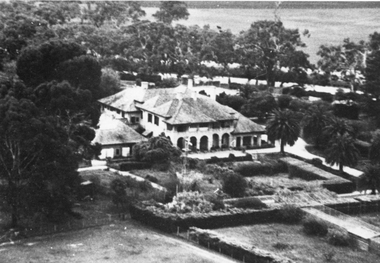 Stawell Historical Society Inc
Photograph, “Warranooke” Homestead in Glenorchy 1867 -- aerial view
Aerial View of “Warranooke” Homestead. “Warranooke” Homestead built 1867 enlarged 1926. Shows extensive gardens at front. A very early property in our district Warranooke The main names associated with the property Ayrey - Darnell - Nicoll, later Campbell. Mrs. Campbell built Charles Ayrey's daughter. The Campbells built up the station buildings. The homestead was virtually rebuilt in brick, making it one of the largest and most elaborate in the East Wimmera. Warranooke homestead built 1867, enlarged 1926 destroyed by fire 13th Feb. 1979.Black and white aerial photograph of building showing landscape around the homestead. The photo is on a card with some gold decorations.glenorchy -
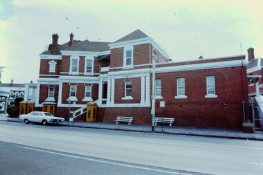
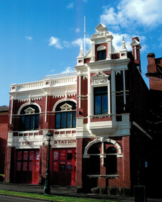 Bendigo Historical Society Inc.
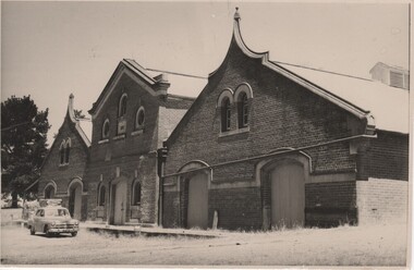
Document - Bendigo Fire Station View Street, 1960-1980s
In 1889 the three central fire brigades of Bendigo were amalgamated and a new fire station was erected in View Street (the third to be built on this site). This two storied brick building designed by Wm. Beebe forms an integral past of the View Street landscape. The red brick, white plaster relief trimmings and window frames with greenish lead-light decoration, all reflect the late Victorian style of the building. The ground floor contained an engine station and call room with stalls to accomodate three horses immediately behind. Upstairs in the main building is a handsome drill hall.Series of letters between Miss Starke and Miss Mathison re classification of the building by the National Trust; Letter to the Country Fire Authority (CFA) re classification; Media Release; National Trust data survey form; two photos of the fire stationhistory, national trust bendigo collection, bendigo, bendigo fire station -
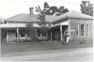
 Kew Historical Society Inc
Photograph - Former Kew Court House : rear buildings facing Cotham Road, 1996
A civic campaign for new public offices developed in Kew in the 1880s. After much deliberation, the location chosen was the junction of Bulleen and Cotham Roads. The buildings were designed by George Watson and John Henry Harvey, architects within the Department of Public Works (Victoria). Building was commenced in 1887, and after one year, the buildings were opened. The Post Office was transferred to the new Commonwealth Government in 1901. The Police Station and Court House, sold by the Victorian Government to the City of Boroondara in 2007, are now a community cultural centre and performing arts venue.The buildings were listed on the Victorian Heritage Register Register (HO885) in 1991. They are historically and architecturally significant to the State of Victoria because Watson and Harvey's designs exhibit diversity in integrating civil offices, they accommodate the apex of road junctions, and they demonstrate a departure from the contemporaneously favoured High Victorian Classical to the Queen Anne style in the design of civic buildings.Original print positive photograph of two buildings on Cotham Road at the rear of the Kew Court House. On the left is a red brick public toilet block, designed by Roland Chipperfield. On the right is a red brick garage; a later addition to the Court House complex.kew court house, public offices -- kew (vic), public toilet -- kew (vic.), kew police station -
 Kew Historical Society Inc
Slide - Stairs: Kew Post Office, 1980
A civic campaign for new public offices developed in Kew in the 1880s. After much deliberation, the location chosen was the junction of Bulleen and Cotham Roads. The buildings were designed by George Watson and John Henry Harvey, architects within the Department of Public Works (Victoria). Building was commenced in 1887, and after one year, the buildings were opened. The Post Office was transferred to the new Commonwealth Government in 1901. The Police Station and Court House, sold by the Victorian Government to the City of Boroondara in 2007, are now a community cultural centre and performing arts venue.The buildings were listed on the Victorian Heritage Register Register (HO885) in 1991. They are historically and architecturally significant to the State of Victoria because Watson and Harvey's designs exhibit diversity in integrating civil offices, they accommodate the apex of road junctions, and they demonstrate a departure from the contemporaneously favoured High Victorian Classical to the Queen Anne style in the design of civic buildings. 35mm colour transparency of the stairs on the left side of the Kew Post Office. The [former] Post Office is a significant example of the English Queen Anne Revival style. The photograph was taken as part of a series by Ralph Andrews (Department of Building, RMIT) in April 1980.kew post office, khs - slides, new public offices -- kew (vic.), architectural styles -- english queen anne revival -
 Kew Historical Society Inc
Slide - Kew Post Office, 1980
A civic campaign for new public offices developed in Kew in the 1880s. After much deliberation, the location chosen was the junction of Bulleen and Cotham Roads. The buildings were designed by George Watson and John Henry Harvey, architects within the Department of Public Works (Victoria). Building was commenced in 1887, and after one year, the buildings were opened. The Post Office was transferred to the new Commonwealth Government in 1901. The Police Station and Court House, sold by the Victorian Government to the City of Boroondara in 2007, are now a community cultural centre and performing arts venue.The buildings were listed on the Victorian Heritage Register Register (HO885) in 1991. They are historically and architecturally significant to the State of Victoria because Watson and Harvey's designs exhibit diversity in integrating civil offices, they accommodate the apex of road junctions, and they demonstrate a departure from the contemporaneously favoured High Victorian Classical to the Queen Anne style in the design of civic buildings. 35mm colour transparency of the Cotham Road facade of the Kew Post Office. The [former] post office is a significant example of the English Queen Anne Revival style. The photograph was taken as part of a series by Ralph Andrews (Department of Building, RMIT) in April 1980.kew post office, khs - slides, new public offices -- kew (vic.), architectural styles -- english queen anne revival -
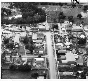 Charlton Golden Grains Museum Inc
Photograph, Aerial photo of Armstrong St, Charlton, c.1974
Aerial photo looking down Armstrong St. Camp street on the left, Shire Hall on the right. High St runs across the photo. The Avoca River is visible in the top LH side. The swimming pool and bowling green is above the rive. On High St (from L-R) Dr Surgery, H Bath Chemist, Grocery, Roy Dobson, Hairdresser, Stowe's, Westpac Bank (two storey white building), Dillon's Building, Globe Hotel, Charlton Club, butcher shop, Arundell's shoe shop, Watson's Stock & Station Agency, Bullock's grocery, Williams St (Curtin Ave), Bannon's Butchers, East Charlton Hotel, MB Luth & Co, Lou's cafe. The old sale yards are at the end of Williams Street. Camp St lower side (from L-R) Court House, Police residence, Police Station, Telecom on corner. The photo is thought to be taken from Ossie Sanderson's airplane in 1974.Black & white aerial photo looking down a broad street that ends in a t-intersection. There is a street that comes off to the left about 1/3 of the way up the photo. There is a large building directly opposite this street. In the upper right there is a two storey building with arches on its verandah. In the upper LH side there is a swimming pool and bowling greens.armstrong st charlton, charlton, business, industry, westpac bank, globe hotel, east charlton hotel, dillon building -
 Northern District School of Nursing. Managed by Bendigo Historical Society Inc.
Photograph - Nurses' Home
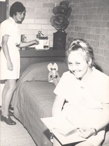
New hostel at NDSN - new building commenced in July 1968 seated Pauline Smith - Mildura Student. Standing Lois Baker - Castlemaine studentNurses Home (New Hostel) Building commenced July 1968. Black and White Photo of 2 females in nurses uniforms. One is sitting on a single bed and the 2nd nurse is standing at the head of the bed adjusting a radioCopyright - Bendigo Advertiser newspapersnursing history, nursing information, new hostel building -
 Mission to Seafarers Victoria
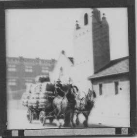
Slide - Glass slide, Black and white, Mission to seamen building, Flinders St and loaded horse-drawn wagon, circa 1920s
This Spanish Mission style building first opened in 1917 and has been in continual use since as the Mission to seamen and later Mission to Seafarers at a location initially known as the extension to Flinders St near the Australian Wharf and later address known as 717 Flinders St. "The Extension Bond and Free stores" building which can be seen in the background can be identified on an aerial photograph of the area dated 1927.This image besides showing an early view of the current Mission to Seafarers building also features a glimpse of the early 20th C (Flinders St) Extension Bond ( Store ?) building positioned to make use of the Yarra-side docks known as the Australian Wharf.Positive photograph on medium format glass slide ; b & w image of the chapel and bell tower of 1917 Mission Building, extension to Flinders St. with a loaded horse-drawn dray or wagon being driven in the foreground. . In the background of image can be seen a section of a large warehouse or Bond store building, visible signage reads: "Extension Bond"in upper case letters. The foreground details appear to have been hand touched up with linear ink highlights. Image is slightly blurry. The slide is edged with adhesive tape.pencil cross at lower right corner on adhesive tape edgingmissions to seamen institute, mission building, extension bond store, warehouse -
 Federation University Historical Collection
Photograph - Photograph - Colour, Ballarat School of Mines M.B. John Building
On 11 June 1987 The M.B. John Trade–Art building (Albert Street front) of SMB was officially opened by the Hon. John Cain, Premier of Victoria, in the presence of Morgan B. John. Programs include 3 Dimensional Art, Painting & Decorating, and Engineering Trades. (SMB Institutional Plan 1989)Colour photographs of the Ballarat School of Mines M.B. John Building on Albert Street, Ballarat. Some images show the Ballarat School of Mines Botanical Garden.ballarat school of mines botanical garden, m.b. john building, ballarat school of mines, morgan b. john, m.b. john, morgan bevan john, trades -
 Tarnagulla History Archive
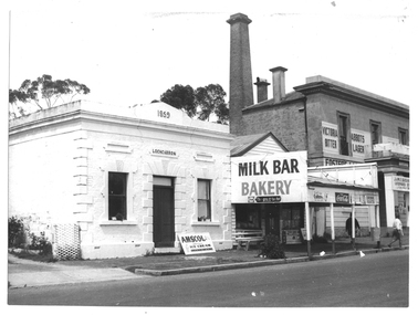
Photograph of milk bar and general store, Tarnagulla, Milk bar and general store, Tarnagulla, circa 1960s-70s
Murray Comrie Collection. This image depicts stores in the main street of Tarnagulla, including the two-storey bank building being used as a licensed general store. The building on the left was also a bank, originally constructed by the Union Bank in 1859, and Is probably the first brick and stone building at Tarnagulla. It was used by the bank until 1888 at which time the Union and Colonial banks amalgamated. After this, the building was used for a variety of purposes. The milk bar section was constructed in the 1920s in an area at the front of what had once been the Bank’s manager’s residence. The Two-story bank building On the right was constructed and used by the Colonial Bank of Australasia (from 1866 to 1888) and, following bank amalgamation, by the Union Bank (from 1888 until closure in 1942). The original site had been occupied by Joseph Foo's store, a large wooden building with attached theatre. While the bank was being built, the Colonial Bank operated from the former Company's Hotel (soon after to become the Borough of Tarnagulla Council Chambers, then the Mechanics’ Institute, and finally, prior to final demolition in 1980, Burstall Hall) The new double-storey building was used by the Colonial Bank from 1866 until 21st February, 1888. The premises were sold to the Union Bank for £2500. The Union Bank moved in and commenced operations on 6th June 1888, continuing until 1942. The building was later used as a general store until the 1990s. It is a now private residence. This is a reasonable copy of an older original. Copy probably made by Murray Comrie in the 1970s. Monochrome photograph depicting a section of Commercial Road, Tarnagulla near the intersection with Poverty Street, including two stores - one a bakery/milk-bar and the other a general store operating in the former Colonial/Union Bank building. Photograph taken from north of milk-bar. Two people walking away from photographer on footpath/curb between the two stores. The building on the left was the Union Bank premises, constructed in 1859 and Tarnagulla's oldest surviving brick building. The Union Bank absorbed the Colonial Bank in 1888, and the Union Bank moved operations next door into the much larger former Colonial Bank premises which had been constructed in 1865/66. After amalgamation, the old Union Bank premises was then used for a variety of purposes from visiting doctor's rooms to cafe, etc. The Union Bank continued to operate at Tarnagulla until closure in 1942, at which time business had fallen away and Tarnagulla Branch had already been downgraded to sub-branch status. tarnagulla, banks, banking, commerce, stores, shopping, shops, food, groceries, buildings, commercial road -
 Rutherglen Historical Society
Photograph - Image, 1954 (Approximate)
Centre section of building was built by the original owner, who was of Scottish decent. The two side sections were added by the Burgoynes (later owners), who were French. The different styles of architecture showing the influences of the owners origins.Photograph of Mt Ophir Cellars. The red brick building is in three sections. Five arched double doors. Arched windows. Ventilator on Roof. Pine tree in background. Car in front. mt ophir cellars, mt ophir winery, burgoynes winery -
 Kew Historical Society Inc
Photograph - Former Congregational Church, Walpole Street, Stewart West, 1977
The site of the former Kew Congregational Church was the earliest 'built' place of religion in Kew. An earlier building by Charles Vickers was replaced by a new brick church designed by Albert Purchas. Following the creation of the Uniting Church, the church at 30 Walpole Street was declared redundant and demolished to make way for the Bodalla Nursing Home (itself later demolished).Colour print positive of the former Congregational Church in Walpole Street, Kew. The front of the polychrome brick building showing the small steeple and the front entrance."Oldest church in Kew. Victoria. Taken Oct '77. Formerly Congregational Church"churches -- kew (vic), congregational churches, walpole street -- kew (vic), albert purchas -
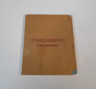 Bendigo Historical Society Inc.
Manual - Set of five manuals: Theory Carpentry, Solid Geometry, Uniform Building Regulations
The donor's father (William Clarence Christopher) was born in 1906 in Williamson Street, Bendigo and was schooled at the Bendigo School of Mines. The notebook on theoretical Carpentry must date from around 1920 when he was an apprentice. His brother James Charles Christopher was a teacher, the Solid Geometry drawings date from 1925-1932 and were submitted by students at Ballarat Junior Technical school. The book od building regulations was used by William Clarence in the 1940's and 50's while employed as a building foreman at Braybrook by Industrial Engineering Ltd.The manuals are covered with brown paper and the title in red or black texter on the front. The theory Carpentry is handwritten, the three Solid Geometry are made up of individual drawings and the Uniform Building Regulations is printed.technical books, school of mines -
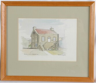 Glenelg Shire Council Cultural Collection
Painting, Ruth Denny, Customs House Portland 1849, 1967
CEMA Art collectionThe painting depicts a stone building with red roof. The front of the building features a double staircase which leads from both sides of the building to a central door. On either side of the door is a window. The side of the building features four windows, three of which are covered. To the left of the building are various plants with the roof of a building in the background. To the right of the building is a fence and blue wall. The work has a plain wooden frame with a mount and glass.Front: Customs House Portland 1849 Ruth Denny 1967 (black, hand-written) Back: Sticker: DEAN'S MU 8269 FOR FRAMING 346 LT. COLLINS ST., MELB. No 20438 Yellow sticker: 3032portland customs house, female artist, female artists, bluestone, bluestone building -
 Buninyong & District Historical Society
Photograph - B/W photograph, St. Alban's Cottage c 1873, former home of Dr. Sparling, July 1993
Built around 1873 by Dr. Sparling, on land formerly occupied by the first Buninyong Inn (aka Jamieson's Hotel). Some materials from the demolished hotel may have been used in building the house.Good example of 1870's professional residence, links to prominent citizen Dr Sparling.B/W Photograph, Polychrome brick cottage, L-fronted with bullnose verandah, on bluestone foundations with low bluestone fence. Signs "Buninyong Antiques" (under verandah) and "Antiques" on front of building.buninyong, sparling, jamieson, house, brick -
 Glenelg Shire Council Cultural Collection
Photograph - Photograph - Julia Street, Portland, n.d
Displayed at History House.Black and white photo. Looking west to east, Julia Street. First 2 buildings have verandahs and 1 chimney each. Double storey, stone building, 4 upstairs windows, 2 chimneys. Small building between 2 double storey buildings. Double storey blue stone with verandah. Small building. 4 double storey buildings.Front: Portland-Julia Street, Looking west to east. Back: State Library of South Australia. Photographic Section Reproduction prohibited except with the permission of the copyright holder. Order No. A/6493.street scene, portland street scene, photography -
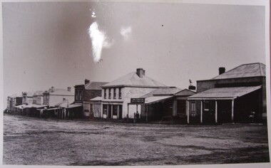
 Stawell Historical Society Inc
Photograph, Stawell Shire Hall 1866 c1980s -- Coloured
Colour Photo Stawell Shire Hall built 1866, c1980. The Shire Hall is in Longfield Street Stawell and has had many changes since 1866. Ronald Campbell, the Shire's second president laid the foundation of the hall on 28th April 1866. The contractors were Hutchings and Delbridge. The first Hall and office were the front part of the existing building. These rooms consisted of two 18 ft square rooms with an entrance hall separating them. The facade was almost the same as it is today. The building cost 502 pounds.Colour photograph of Stawell Shire Hall 1866. Very similar view to 0084 the photo clearly showing the two windows and arched entrance door. Landscaping outside the building is exactly the same as in 0084. stawell -
 Glenelg Shire Council Cultural Collection
Photograph - Photograph - Stone Building, 1920-1939
Photographs taken by Esther Winifred Hall (nee Smallpage) - great grand-daughter of Stephen George Henty. Taken in 1934 Centenary Celebrations in Portland.Black and white photograph showing a stone building with awning at front and ball-shaped finials. Notices pinned to front wall of building and telegraph poles to left of building. Pair of narrow windows set high at front of building and on end wall at right. Street lamp to left of building.Front: (no inscriptions) Back: (no inscriptions)