Showing 2565 items
matching aerial
-
 Ballaarat Mechanics' Institute (BMI Ballarat)
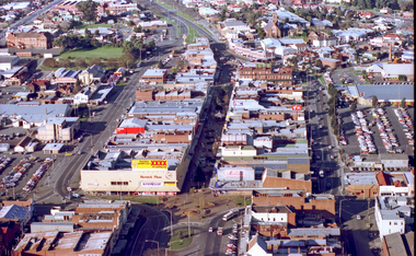
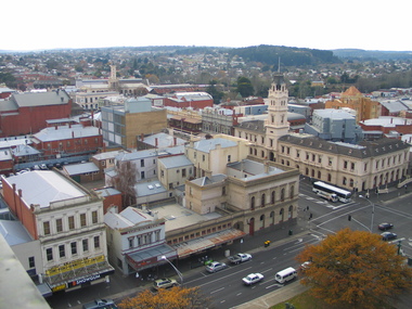
Aerial view of Bridge Mall area, Max Harris
This photograph is from the Max Harris Collection held by the Ballaraat Mechanics' Institute. Please contact BMI for all print and usage inquiries.ballarat, bridge mall, bakery hill, 1980s, aerial -
 Ballaarat Mechanics' Institute (BMI Ballarat)
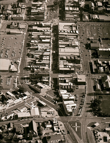
Aerial Bridge Mall modern aerial shot 1980's
This photograph is from the Max Harris Collection held by the Ballaraat Mechanics' Institute. Please contact BMI for all print and usage inquiries.ballarat, aerial, bridge mall, modern, 1980's -
 Victorian Interpretive Projects Inc.
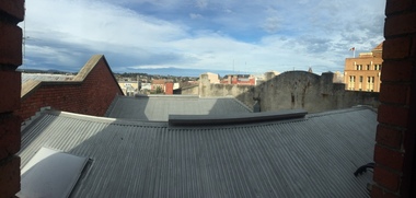
Photograph - Colour, Clare Gervasoni, Ballarat towards Sturt Street from the Ballarat Trades Hall, 2015, 30/07/2015
Rooflines and buildings from the top of the Ballarat Trades Hall in Camp Street Ballarat.ballarat trades hall, camp street, sturt street, ballarat, aerial -
 National Vietnam Veterans Museum (NVVM)
Film - Film, DVD, Wings over Vietnam: Volume 1, 1996
united states. air force -- history, vietnam war, 1961-1975 -- aerial operations, military operations, aerial -
National Vietnam Veterans Museum (NVVM)
Film - Film, DVD, Wings over Vietnam: Volume 3, 1996
united states. air force -- history, vietnam war, 1961-1975 -- aerial operations, military operations, aerial -
 Ballarat Heritage Services
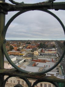
Photograph, L.J. Gervasoni, Ballarat from the Town Hall Tower, 2006, 14/06/2006
Ballarat looking toward St Patrick's Cathedral, from the Ballarat Town Hall tower. ballarat, aerial, ballarat town hall tower, st patrick's cathedral, sturt street -
 Ballarat Heritage Services
Photograph, L.J. Gervasoni, Ballarat from the Town Hall Tower, 2006, 14/06/2006
Ballarat looking toward the former Ballarat Post Office, from the Ballarat Town Hall tower. ballarat, aerial, ballarat town hall tower, sturt street, ballarat post office -
 Eltham District Historical Society Inc
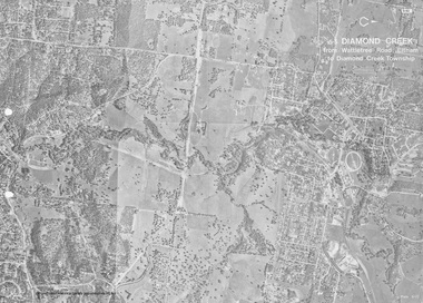
Work on paper (Sub-Item) - Photograph, Diamond Creek from Wattletree Road, Eltham to Diamond Creek township
Black and white aerial view of Diamond Creek from Wattletree Road, Eltham to Diamond Creek Townshipeltham, drain, diamond creek -
 Greensborough Historical Society
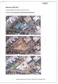
Article and Photograph, Watermarc 2009-2016, 2016_
Aerial photographs of the Greensborough Pool site being redeveloped into WaterMarc (2009-2016). Images from nearmap.com.auThis text and photographs were copied from a Facebook site. Members are people who lived in the Greensborough area and share their reminiscences of the area with others. The site is administered by a GHS member but is not officially affiliated with the Society. Any information is the opinion of the contributor. Photographs and text sourced from social media.greensborough pool, watermarc -
 Greensborough Historical Society
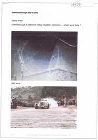
Article and Photograph, Greensborough Hill Climb, 2017_
Information and photos about the Greensborough Hill Climb included a copy of the 1945 aerial survey showing the track.This photograph and text was copied from a Facebook site. Members are people who lived in the Greensborough area and share their reminiscences of the area with others. The site is administered by a GHS member but is not officially affiliated with the Society. Any information is the opinion of the contributor. Article and photograph sourced from social media.greensborough hill climb 1945, bill halliburton -
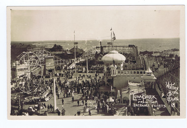 St Kilda Historical Society
Photograph, Whitney Bros Electric Post Card Studio, Luna Park, c. 1900s
Luna Park with crowd milling, aerial view from the entrance towers, St Kilda bay behind.black and white image on front of postcard, unmounted, good conditionFront: Luna Park From The Entrance Towers; Whitney Bros. Photo 18; Back: Whitney Bros, Electric Post Card Studio, Luna Park, St kilda. Melbourne, Australia. -
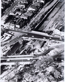 St Kilda Historical Society
Photograph, Queens Way Underpass, Under construction 1968, c. 1968
aerial view. hand written on back: Queens Way underpass under construction. Photo filed 30.4.1968black and white photograph in plastic coverQueen's way Underpass Under Construction 1968 "Age". Photo filed 30.4.1968. V6429 H71 C170. Copyright. This photograph may not be reproduced without permission in writing from the Editor of "The Age". 250 Spencer Street, Melbourne and 39/41 York st, Sydney. -
Creswick Campus Historical Collection - University of Melbourne
Equipment, Sketchmaster
Aerial photograph converter. Complete instrument with instructions, a number of parts in a large grey wooden custom boxEquipment -
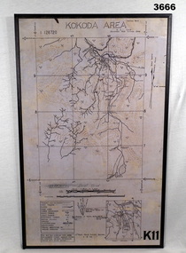 Bendigo Military Museum
Map - MAP, KOKODA MOUNTED, 2nd Aust Field Survey Section, 4.9.1942
Map was compiled from aerial photos without ground control or inspection & with information received from Major CAMERON.Laminated map of Kokoda area on board backing with black border. Black printing on cream / fawn background. White hanging strap on back. Information ledger bottom LHS. Kokoda inset bottom RHS.Printed at top: “KOKODA AREA” Printed at bottom “RHS: K11”map, kokoda, mounted -
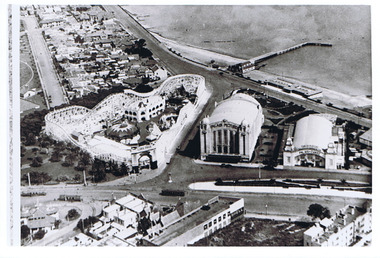 St Kilda Historical Society
Photograph - Photograph - aerial view, 1920s
Aerial view of Luna Park, Palais Pictures, Palais de Danse, St Kilda Pier late 1920sblack and white, arial photograph luna park, palais de danse, palais pictures, st kilda pier -
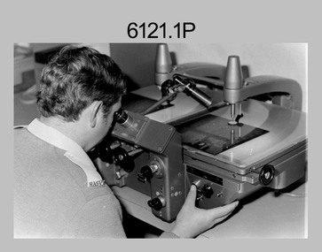 Bendigo Military Museum
photograph - Aerotriangulation Production – Army Survey Regiment, Fortuna, Bendigo, c1980
This collection of five photos was most likely taken in 1980. Wild PUG4 point transfer devices were used by technicians in Air Survey Squadron to stereoscopically view the photography containing the survey control points and the mapping aerial photography. The Control points were transferred from the control photography to the mapping diapositives of aerial photography by drilling their locations into the photographic emulsion. The Zeiss (Jena) Stecometer analytic stereocomparator for air photography was introduced at Air Survey Squadron in 1963. Aerotriangulation production was expedited using computers for analytical photogrammetric processes. The technician accurately measured between pass, tie, and survey control points on aerial photographs.Air Survey Squadron Aerotriangulation Section - Army Survey Regiment, Bendigo. c1980. This is a set of five photographs of Air Survey Squadron personnel operating aerotriangulation equipment at the Army Survey Regiment at Fortuna, Bendigo, c1980. Photographs .1P to .4P are on 35mm negative film and were scanned at 96 dpi. Black and white photo .5P is on photographic paper and was scanned at 300 dpi. They are part of the Army Survey Regiment’s Collection. .1) - Photo, black & white, c1980, Wild PUG4 point transfer device, unidentified technician. .2) - Photo, black & white, c1980, Wild PUG4 point transfer device, unidentified technician. .3) - Photo, black & white, c1980, Wild PUG4 point transfer device, unidentified technician. .4) - Photo, black & white, c1980, Zeiss (Jena) Stecometer, unidentified technician. .5) - Photo, black & white, c1980, Zeiss (Jena) Stecometer..1P to .5P No personnel are identified.royal australian survey corps, rasvy, army survey regiment, army svy regt, fortuna, asr, air survey, aerotrig -
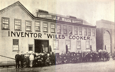 Federation University Historical Collection
Book, Tulloch & King, Printers, M. McCallum's Ballarat District Citizens and Sports, 1916, 1916
A biographical gallery of "Who's Who" in public, political, official, judicial, patriotic, naval, military, charitable, professional, scientific, artistic, journalistic, ecclesiastical, religious, temperance, industrial, clerical, mercantile, commercial, aerial, scholastic, social club, musical, dramatic, friendly society, fraternal, athletic and sporting life, with Ballarat associations, past or present.Small hard covered brown book of 142 pages including advertisements.Stamped "The School of Mines Industries & Science Ballaratballarat district citizens and sports, m. m. mccallum, ballarat, citizens and sports at home and abroad, citizens and sports, political, official, judicial, patriotic, naval, military, charitable, professional, scientific, artistic, journalistic, ecclesiastical, religious, temperance, industrial, clerical, mercantile, commercial, aerial, scholastic, social club, musical, dramatic, friendly society, fraternal, athletic and sporting life, ballarat associations, clarendon college advertisement, wiles cooker, e. rowlands, koomah spa, thomas a. williams, leslie coulter, lela lake, margaret mcnanamny, leslie morshead, alice thwaites, james wiles, alfred williams -
Glenelg Shire Council Cultural Collection
Photograph - Photograph - Aerial photograph of an area of Portland, Victoria, 1955
Port of Portland CollectionA black and white aerial photograph taken from the N.W. of T.B.& S. abattoir, red brick wool store, petroleum installations, north/central Portland residential areas and Portland Harbour.Front: NOV 1955 'AIRSPY PHOTO' ref NO 2/b/74port of portland -
Glenelg Shire Council Cultural Collection
Photograph - Photograph - aerial view of Portland coastline, c. 1954
Black and white aerial photograph of coastline around Portland. Black border, scale all sides, 5 rows of 3 't' at regular intervals. Buildings visible most areas of photoFront: '607 -107' -- handwritten, white, lower border 'RUN 5' 'PORTLAND', printed, white, lower border -
Glenelg Shire Council Cultural Collection
Photograph - Photograph - aerial view of Portland, c. 1954
Black and white aerial photograph of coastline around Portland. Black border, scale all sides, 5 rows of 3 't' at regular intervals. Similar to 8465. Slightly less oceanFront: '607 - 62 ' - handwritten, white, border 'RUN 7PORTLAND', printed, white, borderaerial photography, central portland, portland harbour, south west coastline -
Glenelg Shire Council Cultural Collection
Photograph - Photograph - N.W., of T.B.& S. abattoir; red brick wool store; petroleum installations; north/central Portland residential areas and Portland Harbour, 1955
Port of Portland CollectionFront: NOV 1955 'AIRSPY PHOTO' ref NO 2/b/74port of portland archives, portland harbour, portland residential areas, tb and s abattoir, red brick wool store, petroleum installations -
Glenelg Shire Council Cultural Collection
Photograph - Photograph - aerial view of Portland, c. 1954
Black and white aerial photograph of coastline around Portland. Black border, scale all sides, 5 rows of 3 't' at regular intervals. Similar to 8468, more ocean visibleFront: '607 - 87 ' - handwritten, white, border 'RUN - 6 PORTLAND', printed, white, borderaerial photography, central portland, portland harbour, south west coastline -
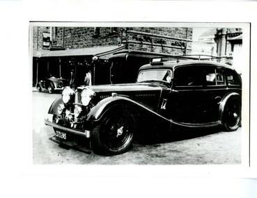 Victoria Police Museum
Photograph (police car), Kodak
Alvis Wireless Patrol car registration number 171-245, circa 1937 taken in the Russell Street HQ yard. The "Police" sign and tubing containing wireless aerials can be seen.police vehicles; transport; motor police branch; alvis car; wireless patrol -
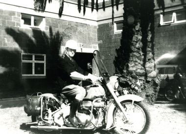 Victoria Police Museum
Photograph (police motorcycle)
Dick Askwith, wearing full uniform including helmet, tunic, elbow length gloves, jodphurs and riding boots, astride an Aerial motorcycle with a large palm tree in the background. Circa 1960police vehicles; wireless patrol; motor transport branch; motor transport section; police motorcycles; ariel motorcycle; askwith, richard -
Glenelg Shire Council Cultural Collection
Photograph - Photograph - aerial view of Port of Portland, c. 1974
Port of Portland Authority archives.Front: (no inscriptions) Back: (no inscriptions)port of portland archives, aerial photography, portland harbour, k s anderson wharf, s l patterson wharf -
Glenelg Shire Council Cultural Collection
Photograph - Photograph - Main Breakwater Construction, n.d
Port of Portland Authority Archivesport of portland archives, portland harbour, ship berthed, ocean pier, lee breakwater -
Port Melbourne Historical & Preservation Society
Photograph - Aerial view of Port Melbourne, overlaid, Charter Keck, Cramer, Nov 2006
Black and White aerial photo with red map overlay, labelled "Port Melbourne 1946 overlaid" in gold/brown metal frame . Shows Yarra River, Coode Canal and Hobson's Bay.built environment - industrial, engineering - canals and drainage, coode island, yarra river, melbourne harbor trust - port of melbourne authority -
Port Melbourne Historical & Preservation Society
Photograph - Aerial view of four US ships at princes Pier, Port Melbourne, Airsky, Aug 1925
After death of Euralee, the original was found among her papers, mounted on brown cardboard'sepia' lasercopy from 1925 aerial photograph of four US ships at Princes Pier in August 1925, found by Clark Towson after his grandmother Euralee's death in December 2001original had the four ships names at Princes Pier, Port Melbourne, August 1925.piers and wharves - princes pier, uss oklahoma, uss seattle, uss nevada, uss pennsylvania -
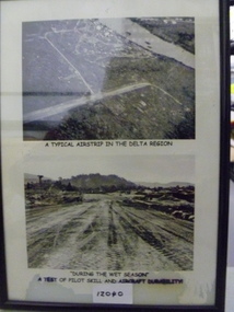 National Vietnam Veterans Museum (NVVM)
Photograph, A Typical Airstrip In The Delta Region
Two black and white photograph in a frame - Top photo is an aerial photo of an unknown airstrip in the Delta Region. Bottom photo depicts tyre tracks on the muddy airstrip during the wet seasonTop photo - 'A Typical Airstrip In The Delta Region' Bottom photo - 'During the wet season a test of pilot skill and aircraft durabilityairstrip, wet season, photograph -
Whitehorse Historical Society Inc.
Article, Lakeside fun, 1993
Nunawading Rotary Club's annual fun day at Blackburn Lake.Nunawading Rotary Club's annual fun day at Blackburn Lake. The Rotary Club donated a series of aerial photos of Nunawading going back 60 years which will be on show in the visitor's centre.Nunawading Rotary Club's annual fun day at Blackburn Lake.nunawading rotary club, blackburn lake, meagher, dorothy, tierney, peter, wittick, max, francis, john