Showing 26605 items
matching buchan-river-view-hotel
-
 Rutherglen Historical Society
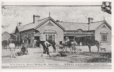
Image, Advance Australia Hotel - Great Northern Township, c1893
Black and white photograph of a hotel, with a number of people, dogs and horses, and two horse carts shown in the foreground.Written on back of photo "Opened 19/4/1893"advance australia hotel, hotels -
 Old Colonists' Association of Ballarat Inc.
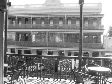
Photograph - Photograph - Black and White, Lisa Gervasoni, The George Hotel, Ballarat, 23/03/2017
Black and white photograph of the George Hotel in Lydiard Street, taken from the balcony of the Old Colonists' Hall.george hotel, ballarat old colonists' club, old colonists' hall, balcony -
 Tarnagulla History Archive
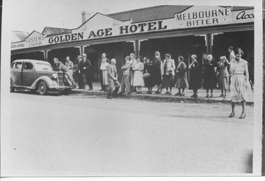
Photograph, People Outside the Golden Age Hotel, Tarnagulla, 1937
Donald Clark Collection. A monochrome photograph of people standing outside the Golden Age Hotel in Tarnagulla, at Easter in 1937. Copy photograph. -
 Tarnagulla History Archive
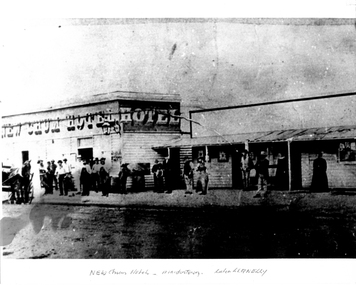
Photograph, New Chum Hotel, Llanelly, circa 1870s-1880s
Donald Clark Collection. A monochrome photograph of the New Chum Hotel in Maidentown,Victoria (town later renamed Llanelly). Copy photograph. llanelly, hotels -
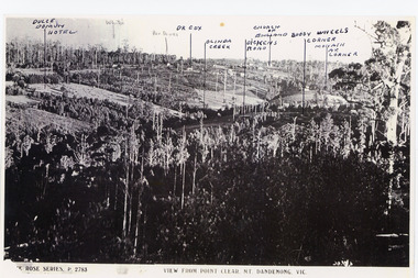 Mt Dandenong & District Historical Society Inc.
Photograph, View from Point Clear, Mt Dandenong, Vic
Rose Series Postcard number 2783Copy of Rose Series postcard #2783 showing view from Point Clear. This is taken from Ridge Road. The following indicators have been marked on the photograph L-R Dulce Domun Hotel, White's, Rev. Davies, Dr. Cox, Olinda Creek, Dickens Road, Church of England, Buggy Wheels Corner, Monash Ave. Corner.mount dandenong, ridge road, rose series, point clear -
 Ringwood and District Historical Society
Photograph, Club Hotel, Mount Dandenong Road, Ringwood East in 1924, 1924
Black and white photograph of the Club Hotel on Mount Dandenong Road, East Ringwood. The image was copied from the "Ringwood East Electric Station Estate" land sales brochure dated 1st November 1924. Refer to #5132. The hotel has a long association with the Reddish family, thus given the name of "Daisy's Hotel". Included 2 copies of the photograph. Ryman Healthcare bought the site in 2019, including the garden supply business next door, making up a 2.2ha area. The proposal was for a $220 million retirement village to be built. The location is next to Ringwood Lake with the old hotel being knocked down in the early 2020s.Was item H7 in the previous numbering system. -
![View of a Victorian Sheep Station / [by] Nicholas Caire, circa 1876](/media/collectors/550653872162f11fb04854aa/items/577b58dad0cdd10948cfdc7b/item-media/577b5942d0cdd10948d01fbf/item-fit-380x285.jpg) Kew Historical Society Inc
Kew Historical Society IncPhotograph, View of a Victorian Sheep Station, c.1876
Nicholas Caire was born on Guernsey in the Channel Islands in 1837. He arrived in Adelaide with his parents in about 1860. In 1867, following photographic journeys in Gippsland, he opened a studio in Adelaide. From 1870 to 1876 he lived and worked in Talbot in Central Victoria. In 1876 he purchased T. F. Chuck's studios in the Royal Arcade Melbourne. In 1885, following the introduction of dry plate photography, he began a series of landscape series, which were commercially successful. As a photographer, he travelled extensively through Victoria, photographing places few of his contemporaries had previously seen. He died in 1918. Reference: Jack Cato, 'Caire, Nicholas John (1837–1918)', Australian Dictionary of Biography.An original, rare photograph from the series 'Views of Victoria: General Series' by the photographer, Nicholas Caire (1837-1918). The series of 60 photographs that comprise the series was issued c. 1876 and reinforced a neo-Romantic view of the Australian landscape to which a growing nationalist movement would respond. Nicholas Caire was active as a photographer in Australia from 1858 until his death in 1918. His vision of the Australian bush and pioneer life had a counterpart in the works of Henry Lawson and other nationalist poets, authors and painters.Views of Victoria (General Series) No.29 / ‘View of a Victorian Sheep Station’ / Albumen silver photograph mounted on boardOn Reverse: ‘The present illustration is characteristic of a Squatter’s Station in Victoria, and is situated near Elphinstone. In the centre of the picture may be seen the Squatter’s residence or head-quarters surrounded by sheds and out-houses, and in the foreground is a flock of sheep in charge of a lad. Of late years it has become the practice to erect fences around the Australian Sheep Stations, which necessitates only the services of a boundary rider, and dispenses with those of a number of shepherds.’nicholas caire (1837-1918), landscape photography -
![View of Sailor’s Creek Falls / [by] Nicholas Caire, circa 1876](/media/collectors/550653872162f11fb04854aa/items/577b5d13d0cdd10948d24e07/item-media/577b5d7dd0cdd10948d282ff/item-fit-380x285.jpg) Kew Historical Society Inc
Kew Historical Society IncPhotograph, Anglo-Australasian Photographic Company, View of Sailor’s Creek Falls, c. 1876
Nicholas Caire was born on Guernsey in the Channel Islands in 1837. He arrived in Adelaide with his parents in about 1860. In 1867, following photographic journeys in Gippsland, he opened a studio in Adelaide. From 1870 to 1876 he lived and worked in Talbot in Central Victoria. In 1876 he purchased T. F. Chuck's studios in the Royal Arcade Melbourne. In 1885, following the introduction of dry plate photography, he began a series of landscape series, which were commercially successful. As a photographer, he travelled extensively through Victoria, photographing places few of his contemporaries had previously seen. He died in 1918. Reference: Jack Cato, 'Caire, Nicholas John (1837–1918)', Australian Dictionary of Biography.An original, rare photograph from the series 'Views of Victoria: General Series' by the photographer, Nicholas Caire (1837-1918). The series of 60 photographs that comprise the series was issued c. 1876 and reinforced a neo-Romantic view of the Australian landscape to which a growing nationalist movement would respond. Nicholas Caire was active as a photographer in Australia from 1858 until his death in 1918. His vision of the Australian bush and pioneer life had a counterpart in the works of Henry Lawson and other nationalist poets, authors and painters.Views of Victoria (General Series) No.32 / 'View of Sailor’s Creek Falls’ / Albumen silver photograph mounted on boardOn Reverse: ‘The Sailor’s Creek Falls are situated near Daylesford, in one of the valleys of the Jim Crow Ranges. The Creek at this particular juncture is naturally adapted for the formation of a large reservoir. The stream of water is small during summer months, but a great body of water may sometimes be seen during the winter or wet seasons.’nicholas caire (1837-1918), sailor's creek (vic), jim crow ranges, daylesford, sailor's falls, photography - landscapes - victoria -
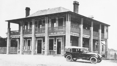
 Kew Historical Society Inc
Photograph - Clifton Hotel, Kew Junction, 1994
Of the eight hotels established in Kew since European settlement, The Hotel Kew, known for most of its existence, as the Clifton Hotel was the seventh to be built in 1868. Its location on the corner of Studley Park Road and High Street at Kew Junction makes it a prominent landmark. Its current name is confusing for local historians as its main rival for the first 52 years was O'Shaughnessy's Hotel (1855), later renamed the Kew Hotel, on the corner of High Street and Denmark Street. Looking at the façade of the Hotel Kew, it is hard to imagine its mid-nineteenth appearance. There have probably been at least four renovations or rebuilding(s) of the structure. The documented renovations have occurred in the 1930s when the late Victorian façade was given an Art Deco update. In about 1970 its façade was again 'improved'. The many publicans who have held the licenses of the Clifton Hotel have been identified in in the 'Tetlow Index' and on the 'Boroondara Local History Wiki'. The most significant of these are Henry Madden (1880-87); Michael O'Donnell (1902-1920); and the Cronin-Ryan family (1935–53ff).Fading colour positive photograph of the Clifton Hotel at Kew Junction on the corner of High Street South and Studley Park Road. The hotel had been modified extensively over time, disguising the original Italianate facade. This is the colour scheme of the fourth restoration, including huge advertising billboards on the roof.Reverse: "Clifton Hotel. Studley Park Road at Kew Junction. 1994clifton hotel -- kew (vic.), hotels -- kew (vic.), kew junction -
 Greensborough Historical Society
Photograph - Digital image, Marilyn Smith, Plenty River bank at Greensborough 2015; Diving platform, 16/08/2015
Steps on the Plenty River embankment in Greensborough, part of the old Plenty River pool, this is the base of the diving platform. A River bank stabilisation project along the Plenty River at Greensborough was conducted by Melbourne Water in 2015.Digital copy of colour photographplenty river, melbourne water -
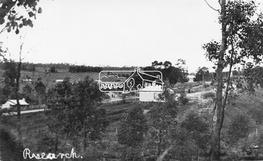 Eltham District Historical Society Inc
Negative - Photograph, Tom Prior, View of Research, Vic, c.1900
View of Research looking down Ingrams Road towards the rear of Doney's store, Main Road left to right. General Store centre. Ingrams Road opposite General Store. Hotel right of centre. The small building at left of photo housed the school for a short period of time but it was too hot in summer and the community lobbied for a more substantial school.This photo forms part of a collection of photographs gathered by the Shire of Eltham for their centenary project book,"Pioneers and Painters: 100 years of the Shire of Eltham" by Alan Marshall (1971). The collection of over 500 images is held in partnership between Eltham District Historical Society and Yarra Plenty Regional Library (Eltham Library) and is now formally known as the 'The Shire of Eltham Pioneers Photograph Collection.' It is significant in being the first community sourced collection representing the places and people of the Shire's first one hundred years. The Reynolds family were early settlers in Research. The Reynolds/ Prior collection of photographs were taken by Tom Prior, the maternal uncle of Ivy Reynolds, around 1900 and the 60 photos in the album give a fine overview of many of the landmarks of Research and Eltham over 100 years ago. lvy lived in the family home for many years at 106 Thompson Cres Research. Ivy's father, Ernst Richard Reynolds and grandfather, Richard Reynolds, lived at the same address. Ivy's father Richard worked for Mr. Trail on his property in Research. Reynolds Road is named after the family. Mr Tom Prior (wife Eva) worked at the Melbourne zoo. He was very innovative and made his own camera, using the black cloth hood to exclude the light. The photographs are a reminder of the rural nature of Research and Eltham and its rich heritage.Digital image 120 format B&W negativesepp, shire of eltham pioneers photograph collection, research (vic.), general store, ingrams road, main road, research hotel, doney property, research primary school, reynolds prior collection -
 Whitehorse Historical Society Inc.
Article, A Living, working view of our heritage, 1992
Matheson's Orchard, the last working orchard in NunawadingMatheson's Orchard, the last working orchard in Nunawading will soon be open to the public. Council purchased the orchard in 1988. The plan is to run the orchard as it would have operated in the 1930's providing a living and working view of Nunawading's heritage. The eldest child, Marjory, wife of Rev Rhys miller is writing a history of the orchard for Council.Matheson's Orchard, the last working orchard in Nunawading orchards, matheson, charles, city of nunawading -
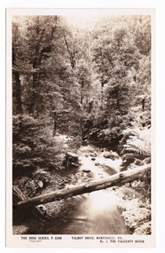 Marysville & District Historical Society
Postcard (item) - Black and white postcard, Rose Stereograph Company, Talbot Drive, Marysville, Vic. No. 3, The Taggerty River, 1913-1967
A postcard in a series produced by the Rose Stereograph Company in Victoria, Australia as a souvenir of Marysville.A black and white photograph taken along Lady Talbot Drive, Marysville, in Victoria, of the Taggerty River. Lady Talbot Drive is a 24 kilometer scenic rainforest car journey which passes a number of walks and waterfalls in the Yarra Ranges National Park. Lady Talbot Drive is named after Lady Sarah Elizabeth, the wife of Sir Reginald Talbot, who was the Governor of Victoria from 25th April, 1904 to 6th July 1908. This postcard was produced by the Rose Stereograph Company as a souvenir of Marysville.POST CARD The "Rose " Series/ De Luxe A Real Photograph/ Produced in Australia Published by the Rose Stereograph Co./ Armadale, Victoria. Dear John,/ I am writing this note in my room/ at Mt. Kitchener House before sallying forth for/ dinner. Unfortunately space does not permit/ me to tell you much, but I must let you know/ that yesterday morning (Monday), a blanket of/ snow covered the township of Marysville to a/ depth of three or four inches. Further up, near/ Keppel's Lookout, which we visited yesterday, it/ was nearly a foot deep everywhere, and it snowed/ the whole time we were walking./ Will tell you all later, your friend, Billtalbot drive, marysville, victoria, taggerty river, p. 2308, rose series postcard, postcard, souvenir, sir reginald talbot, lady sarah elizabeth talbot -
Whitehorse Historical Society Inc.
Map, Yarra River, 1839
Copy of T.H. Nott's original survey of 'Yarra Yarra River' taken from 'Lilydale' by Grace Aveling.Copy of T.H. Nott's original survey of 'Yarra Yarra River' taken from 'Lilydale' by Grace Aveling. Covers area from Templestowe to Yarra Glen.Copy of T.H. Nott's original survey of 'Yarra Yarra River' taken from 'Lilydale' by Grace Aveling. maps, yarra river -
Lakes Entrance Historical Society
Book, Orbost Historical Society Inc, Barns of the Snowy River Orbost, 2006
Documents the distinctive slatted barns of the Lower Snowy River, Orbost, Victoria. Includes sketch maps, barn plans, history of area and families and personal ineterviews.Ngaire Donald May Leatchland settlement, agriculture, natural disasters, transport -
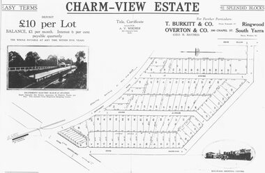 Ringwood and District Historical Society
Photograph, Land sale advertisement for Charm View Estate, Heathmont - 1927
Map - Charm-View EstateTyped below photograph, "From 1927 land subdivision brochure". -
Federation University Historical Collection
Image, Aerial View of Ballarat
Lithograph of an aerial view of Ballarat.ballarat, aerial -
 University of Melbourne, Burnley Campus Archives
Photograph - Black and white negative, Garden View, 1922-1923
Garden View. Pavilion in background.pavilion, j.l. provan, garden view -
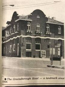 Greensborough Historical Society
Newspaper Clipping - Digital Image, Diamond Valley News, Greensborough Hotel 1984, 1984_
Newspaper clipping showing the Greensborough Hotel in 1984. The hotel was built in 1926`.This view shows details of the exterior of the building.Digital copy of newspaper clippinggreensborough hotel -
 Greensborough Historical Society
Photograph - Digital image, Marilyn Smith et al, Janefield Precinct: more pondering - Janefield view, 27/11/2014
More pondering - Janefield view. The remains of this site are between Greensborough and Janefield. A RAAF Hygiene Training Camp was located on the Plenty River, just south of the Janefield community. It was in use from 1944 to 1946. The Camp was constructed from salvaged materials. Instruction included building and maintenance of grease traps, latrines, elementary plumbing and carpentry.Early remains of a WW2 training camp Digital colour photograph. -
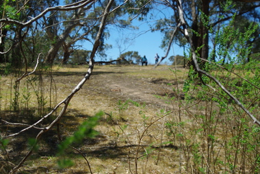
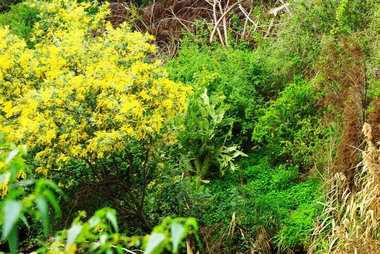 Greensborough Historical Society
Photograph - Digital image, Marilyn Smith, Plenty River bank at Greensborough 2015; Rear of lower Main Street shops, 16/08/2015
Vegetation on the Plenty River embankment in Greensborough. A River bank stabilisation project along the Plenty River at Greensborough was conducted by Melbourne Water in 2015.Digital copy of colour photographplenty river, melbourne water -
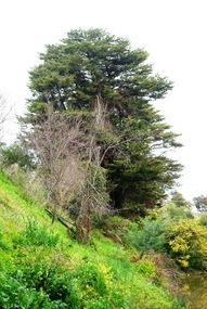 Greensborough Historical Society
Photograph - Digital image, Marilyn Smith, Plenty River bank at Greensborough 2015; Trees, 16/08/2015
Tree on bank of Plenty River in Greensborough. A River bank stabilisation project along the Plenty River at Greensborough was conducted by Melbourne Water in 2015.Digital copy of colour photographplenty river, melbourne water -
 Mt Dandenong & District Historical Society Inc.
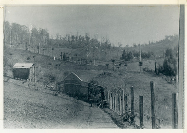
Photograph, View From George Barber's Home On Olinda Creek Towards The Gap. c1905, 1905
Black and white photograph showing view towards The Gap (Jeeves Saddle), (Five Ways) taken c1905. Detailed inscription on back handwritten by John Lundy-Clarke in 1973.1905 (c ) view from Barber’s home on Olinda Creek, towards the Gap, then known as Jeeves Saddle. Barber’s stable in foreground. “Shiloah” Complex centre right. Tait’s house in gully just left of centre. Logan’s house can just be seen under magnifier at top of same gully near line of Barber’s Road. “Kalorama” just below lowest portion of Gap skyline with Barnes (Paynters) house “Iona” to its left. Photo copied 1973. JLC. george barber, shiloah, kalorama, iona, olinda creek, the gap, jeeves saddle, tait, paynter, barber -
 Warrnambool and District Historical Society Inc.
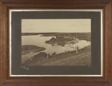
Photograph - Framed Photograph of the Islands in the Hopkins River, Jordan Studios, Warrnambool, 1911
This photograph shows the islands in the Hopkins River in 1911. This section of the river is in the Allansford area, near Jubilee Park (Hopkins River Caravan Park). It was, and still is, a picnic and fishing spot. On one of the islands is an unmarked grave which may be that of Jemima Christine Allan, the first wife of one of the first European settlers in the Allansford area, William Allan. She died in 1842. The photograph was taken by Jordan Studios so the photographer may be either Joseph Jordan, one of the best-known Warrnambool photographers of the past, or his son Arthur, also a well-credentialled photographer.This photograph is considerable historical importance, showing a section of the Hopkins River in the Warrnambool region in 1911.This is a black and white photograph in a wooden frame with a patterned edging. The photograph is inset with a gilt metal edging and enclosed in glass. The backing is wooden with a wire cord for hanging. The photograph shows the river with islands covered in vegetation. On the river are two boats, one wuih four occupants standing up in the boat and the other with two occupants. In the ccntre of the photograph is a tree stump and a dead tree.The Islands Hopkins River Warrnambool 1911 Jordan Photohopkins river, jemima allan, jordan studios -
 Ithacan Historical Society
Photograph, View of Exoghi and Afales Bay - Ithaca, c1970s
At an altitude of 340m, the picturesque village of Exogh in northern Ithaca, lies on the Homeric mountain of Neion. The village overlooks Aphales Bay and across the water the neighbouring island of Lefkada. During the Middle Ages and at the beginning of the Venetian rule, it was one of the most populated villages of the island, offering safety from the pirates, and an excellent view of the channel, the sea and the bays around the northern Ithaca.Some of the earliest Ithacan settlers in Melbourne were from the mountain village of Exoghi, including the founding president AJ.J. Lekatsas (Lucas). The village now has very few permanent residents with most having migrated or moved to the cities of Greece. A coloured photograph of a view overlooking the village of Exoghi and Aphales Bay on the island of Ithaca. The photograph was taken from the bell tower of the church of Panagias (the Virgin/Our Lady) sta Pernarakia located at the top of the mountain. The mountains which are visible across the skyline are the neighbouring island of Lefkada. mountain villages, ithaca -
 Ballarat Tramway Museum
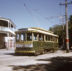
Slide - 27 mm sq slide/s - set of 5, Andrew Howlett, Tram 26 on private tour - View Point line, Mar. 1969
Yields information about a special tram service during March 1969 and some unusual moves.Set of four Colour slides, Kodak white cardboard mount, developed March 1969 of a special tram that apparently ran from the depot via View Point, shunted at Ripon St and again at Hospital corner. ..1 - No. 26 running a special in Wendouree Parade, View Point, with the Lake View Hotel. .2 - ditto - and a catering company in the view, as well as a Telephone box. .3 - running from Ripon St into Sturt St. .4 - shunting at Hospital corner - then possibly crossed 34 at Parker St Loop - see 7668. .5 - ditto, but before .4, with the tram rounding the corner from the North side of Sturt St into Drummond St. It would then appear that the tram then reversed a bit before going back into Sturt St onto the South side. One of a series of tour photos - see Reg item 7667, 7668, 7683 and 7701.ballarat, tramways, trams, view point, wendouree parade, ripon st, hospital corner, sturt st, tours, tram 26 -
 Greensborough Historical Society
Slide - Photograph, John Ramsdale, Plenty River Montmorency: Slide 112, 1990s
Photograph shows a river and banks; this is the Plenty River at Montmorency.Part of the John Ramsdale collection of slides and audio visual material.Colour photograph scanned from slide.No maker's marks. No caption on slide.plenty river, montmorency -
![Junction of the River Watt and Contentment Creek / [by] Nicholas Caire, circa 1876](/media/collectors/550653872162f11fb04854aa/items/57760437d0cdd10a5c49fc3e/item-media/57760510d0cdd10a5c4a8f9c/item-fit-380x285.jpg) Kew Historical Society Inc
Kew Historical Society IncPhotograph, Anglo-Australasian Photographic Company, Junction of the River Watt and Contentment Creek, c. 1876
Nicholas Caire was born on Guernsey in the Channel Islands in 1837. He arrived in Adelaide with his parents in about 1860. In 1867, following photographic journeys in Gippsland, he opened a studio in Adelaide. From 1870 to 1876 he lived and worked in Talbot in Central Victoria. In 1876 he purchased T. F. Chuck's studios in the Royal Arcade Melbourne. In 1885, following the introduction of dry plate photography, he began a series of landscape series, which were commercially successful. As a photographer, he travelled extensively through Victoria, photographing places few of his contemporaries had previously seen. He died in 1918. Reference: Jack Cato, 'Caire, Nicholas John (1837–1918)', Australian Dictionary of Biography.An original, rare photograph from the series 'Views of Victoria: General Series' by the photographer, Nicholas Caire (1837-1918). The series of 60 photographs that comprise the series was issued c. 1876 and reinforced a neo-Romantic view of the Australian landscape to which a growing nationalist movement would respond. Nicholas Caire was active as a photographer in Australia from 1858 until his death in 1918. His vision of the Australian bush and pioneer life had a counterpart in the works of Henry Lawson and other nationalist poets, authors and painters.Albumen Silver Photograph, mounted on Board. printed in ink on support l.c.: JUNCTION OF THE RIVER WATT AND CONTENTMENT CREEK. / COPYRIGHT REGISTERED. printed in ink on support reverse c.: VIEWS OF VICTORIA. / (GENERAL SERIES.) / No. 1. / JUNCTION OF THE RIVER WATT AND CONTENTMENT CREEK. / This scene is situated about two miles to the westward of Fernshawe, a small but extremely romantic township. / The river, at this juncture, is crossed by a fallen tree, as may be seen in the illustration. The track which is seen on / the opposite side of the river leads to the summit of Mt. Munda (3,500 feet high), 4 miles distant, from which place / visitors can see the Australian Alps, in all their mighty grandeur, stretching for hundreds of miles on either side, / and, as far as the eye can reach, impressing a beholder with the appropriateness of their title, being that of the Great Dividing Range. printed in ink on support reverse l.c.l.: J.W. FORBES, Agent, printed in ink on support reverse l.c.: ANGLO-AUSTRALASIAN PHOTOGRAPHIC COMPANY, MELBOURNE. printed in ink on support reverse l.c.r.: 10 Temple Court, Collins Street West.nicholas caire, views of victoria - general series, landscape photography -
 Greensborough Historical Society
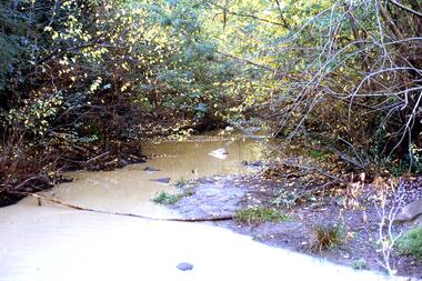
Photograph - Digital image, Marilyn Smith, Plenty River bank at Greensborough 2015; Low water level, 16/08/2015
Low water level Plenty River in Greensborough. A River bank stabilisation project along the Plenty River at Greensborough was conducted by Melbourne Water in 2015.Digital copy of colour photographplenty river, melbourne water -
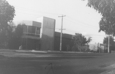 Ringwood and District Historical Society
Photograph, View of Telephone Exchange, Ringwood 1981
Written on back of photograph, "2/81. View Telephone Exchange".