Showing 1260 items matching "mine buildings"
-
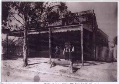
 Clunes Museum
Document - CONSERVATION PLAN, SHIRE OF HEPBURN, SCHOOL OF MINES, 2000
SCHOOL OF MINES, CLUNES BRANCH N0.12, FORMED 1886. ALSO SUPPORTED LOYAL CLUNES LODGE OF ODDFELLOWS, CLUNES INDEPENDENT ORDER OF RECHABITES, A BRANCH OF AUSTRALIAN WOMEN'S ASSOCIATION. IN 1891 ANA (AUSTRALIAN NATIVES ASSOCIATION) 1935 CWA, INNERSPRING MATTRESS FACTORY, CLUNES, INFANT WELFARE, CLUNES ANGLING CLUB NOW OCCUPIES THE BUILDING.SPIRAL BOUND DOCUMENT WITH THE FORMER CLUNES SCHOOL OF MINES DEPICTED IN COLOUR ON THE FRONT PAGE. CONTAINS A CONSERVATION MANAGEMENT PLAN WITH HISTORICAL DETAIL AND COLOURED PHOTOGRAPHS OF THE BUILDING AND SURROUNDSlocal history, conservation management plan, school of mines -
 Clunes Museum
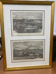
Print, R GROSSE
.1 TWO PRINTS, ONE ABOVE THE OTHER, COPIED TO BUFF COLOURED PAPER, MOUNTED IN GOLD COLOURED TIMBER FRAME. PRINTS TAKEN FROM LITHOGRAPHS .2 FRAMED COLOUR PRINT OF TOWNSHIP OF CLUNES APPROX 1890'S. SAME AS TOP IMAGE OF .1TOP IMAGE PRINTED IN BLACK: TOWN OF CLUNES - POPULATION 4874 NUMBER OF BUILDINGS 1100 GOLD FIRST DISCOVERED HERE Ist JULY 1851 BOTTOM IMAGE PRINTED IN BLACK: PORT PHILLIP AND COLONIAL GOLD MINING COMPANY CLUNESport phillip mine, township of clunes -
 Bendigo Historical Society Inc.
Document - Geological Survey of Victoria, Hustlers Line of Reef, Bendigo, April, 2014
Seven men were killed at the Great Extended Hustler's mine disaster on 2nd May 1914 by an explosion of dynamite occurring as the men were waiting at the plat to ascend the mine at the end of their shift. No blame was attached to anyone in the findings of the inquisition. It was unknown what caused the dynamite to explode. This document formed part of the research done at the time by Bendigo Historical Society, of the 100 years commemoration of the mine disaster, held at Hustler's Hill in 2014. Seven page photocopy of Department of Mines, Bulletin, Geological Survey of Victoria, Hustlers Line of Reef, Bendigo, No. 33 by H.S. Whitelaw. Includes plan of Hustlers Royal Reserve No. 2, (main shaft) showing location on Pall Mall, and location of Post Office and Law Courts; plan of location of Hustlers Royal Reserve No. 2 (Park Shaft) showing Jail (sic), Camp Hill State School, two 'lagoons' in between tennis court, croquet court and bowling green; a plan of the Great Extended Hustler's Shaft and two copied images of Hustler's Hill showing mining buildings, poppet heads and chimneys. Comet, K.K., Hustler's No. 1, Old Comet and United Hustler's and Redan Mines are shown in the images. great extended hustlers, goldmining, accident, quartz, mining, k.k. mine, comet mine, hustler's line of reef, old comet, united hustler's, redan -
 Old Gippstown
Building - Coach House
Built in the 1920s on Tom Fowler's farm at Willow Grove. Used as a shed.A large square-shaped shed with walls of split timber. It has a gabled roof of corrugated iron, while the floor is made up of wooden cobbles. The roofs of the side extensions are made of wood. The floor is Red Gum blocksagriculture, old gippstown, west gippsland, gippsland, gippsland heritage park, goldfields, coal mine, victorian era, moe, historical village, baw baw shire, willow grove, latrobe valley, old gippstown heritage park, horse drawn vehicles, butchers cart, baker's cart, tanjil valley, latrobe city council -
 Lakes Entrance Historical Society
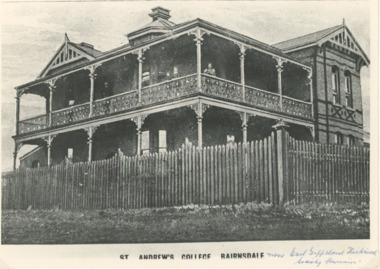
Photograph - St Andrews College Bairnsdale, 1900 c
Designer of original building A F Kramer built 1892 School founded by George Bearham teacher from Scotts College as Bairnsdale College. By 1900 became St. Andrews College with Herbert S Legg as HeadmasterBlack and white copy of photograph of St Andrews College Bairnsdale now East Gippsland Historical Society Museum situated at 40 Macarthur Street Bairnsdale VictoriaSt Andrews College Bairnsdalemines and mining -
 Bendigo Historical Society Inc.
Document - NEW CHUM & VICTORIA LINES OF REEF - NOTES ON JOHNSON'S REEF
Handwritten notes mention 'History of Bendigo by G Mackay, St Mungo Line of Reef from the Belmont Mine, Princess Alexander Shaft, Johnson's no 1 Mine, North Johnson's with notes on buildings, etc. and date 22/9/1892, and the Johnson's Reef Extended dated 29/10/1892, with note on building, mullock heap, and sill 779.18 above sea level. Also mentioned are Leo Chapman and Tom Sayers.document, gold, new chum & victoria lines of reef, notes on johnson's reef, history of bendigo, g mackay, mines' dept, st mungo line of reef, e j dunn report 21/10/92, princess alexander shaft, united devonshire shaft, johnson's reef, garden gully line, johnson's no 1 mine, north johnson's, e j dunn's report 29/10/1892, johnson's reef extended, leo chapman, tom sayers -
 Bendigo Historical Society Inc.
Plan - MARKS COLLECTION: PLAN FOR NEW ENTRANCE VESTIBULE TO FORTUNA VILLA FOR GEO. LANSELL ESQ
Fortuna Villa was owned from 1855 to 1871 by Christopher and Theodore Ballerstedt, Australia’s first mining magnates. In 1871 it was purchased by George Lansell (The Quartz King) being one of Australia’s most successful and adventurous nineteenth century gold mine owners and speculators. Lansell made numerous alterations extensions to the building and remained in the Lansell family until 1935plan for new entrance vestibule to Fortuna Villa for George Lansell Esq. coloured plan detailing new entrance vestibule and open recess across the verandah, and entry steps RHS of page damaged/ tornfortuna villa, geo.lansell esq., building plan, c & t ballerstedt -
 Bendigo Historical Society Inc.
Plan - MARKS COLLECTION: PLAN FOR TWO STOREY OPEN VERANDAH ADDITION TO FRONT AND SIDE ELEVATIONS TO FOTUNA VILLA FOR GEO. LANSELL ESQ
Fortuna Villa was owned from 1855 to 1871 by Christopher and Theodore Ballerstedt, Australia’s first mining magnates. In 1871 it was purchased by George Lansell (The Quartz King) being one of Australia’s most successful and adventurous nineteenth century gold mine owners and speculators. Lansell made numerous alterations extensions to the building and remained in the Lansell family until 1935Plan shows front and side elevations only for the addition of a two storey lacework verandah to Fortuna Villa for George Lansell Esq. Black ink hand drawn plan for verandah elevations Plan badly damaged with water damage, flocking, tears and a hole in the paper plan. Hand drawn additions to the plan with pencilbendigo fortuna villa, george lansell -
 Bendigo Historical Society Inc.
Photograph - STRAUCH COLLECTION: BRITISH AMERICAN HOTEL
This hotel was established c. 1855-1856 and was named after the nearby British and American Mine. The hotel burned down in 1890 and was rebuilt.Copy of photograph of British & American Hotel Rae's Hill Ironbark.photograph, building, british & american hotel, bendigo-hotels -
 Bendigo Historical Society Inc.
Document - MCCOLL, RANKIN AND STANISTREET COLLECTION: INDENTURE BETWEEN KING EDWARD VIII AND MONUMENT HILL CONSOLIDATED MINE, 2/09/1936
Indenture document number 10878, Vol 317 Folio 35044. Foolscap 4 pages including a map, dated 2nd September, 1936, between King Edward VIII (Crown land) and Monument Hill Consolidated (Bendigo) No Liability 'carrying on operations in the Parish of Sandhurst, to occupy and use the land demised as a site for machinery buildings and offices to be used in connexion with 'mining purposes' ' Document signed by Right Hon William Charles Arcedeckne, (Baron Huntingfield) and J. Stanistreet, Manager, affixed with the Common Seal of Monument Hill Consolidated (Bendigo) No Liability. Map drawn on dark buff paper, and fixed to document. Map shows lease 10878 in the Mining District of Bendigo, Parish of Sandhurst, County of Bendigo. N.Area 2.2.24 ( 2 acres, 2 roods, 24 perches ) Lease site on Rowan Street, bordered by Ophir Street. Coloured in purple on plan with small red area. On bottom: ' Note Red Areas Excised. Scale 4 chains to 1 inch, M.M. Var. 8 degrees 32' E. On lease site, New Chum Gully marked, W.B. House, and Permanent Occy. marked on red area. On last page ownership of lease details from 1937 to 1942.bendigo, mining, monument hill consolidated, common seal of monument hill consolidated, nell gwynne mine, south nell gwynne gold mining company, bendigo mine, ophir street, rowan street, mackenzie street.indenture vol 317 fol. 35044. j stanistreet. -
 Bendigo Historical Society Inc.
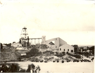
Photograph - CENTRAL NELL GWYNNE GOLD MINE
... buildings and associated mine equipment. Dam in foreground. Three... buildings and associated mine equipment. Dam in foreground. Three ...Black and white photograph. Poppet legs. Corrugated iron buildings and associated mine equipment. Dam in foreground. Three houses at R. Inscriptions: on back - rubber stamp 'Central Nell Gwynne Gold Mining Company. No liability:mine, gold, central nell gwynne mine, bendigo, mines and mining, mines, mining, poppet head, landscape -
 Bendigo Historical Society Inc.
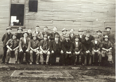
Photograph - NORTH NELL GWYNNE MINE EMPLOYEES, c.1939
Black and white photograph of twenty two miners in front of corrugated iron building. One man in centre of front row dressed in three piece suit and tie. Inscriptions: hand written on back - 'North Nell Gwynne'. 'A Richardson, 29 Harrison St, Bendigo'. Royal Historical Society of Victoria, Bendigo Branch. Circular Stamp on rear. Approx. 1939north nell gwynne, gold mining, gold, nell gwynne, mine employees -
 Bendigo Historical Society Inc.
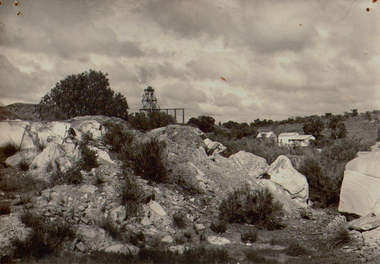
Photograph - CENTRAL NELL GWYNNE MINE, c.1960
Black and white photograph. Poppet head in background. Large rocks in foreground. Two buildings in background on right of poppet head.mining site, nell gwynne mine, gold mining -
Bendigo Historical Society Inc.
Photograph - Napoleon Reef Gold Battery Winder Shed, 1936
The Napoleon mine site was situated near Harvey Street and Union Street, Ironbark. It was registered under the Companies Act in 1940, with John Jepson Stanistreet as Manager. Article in Age newspaper: https://trove.nla.gov.au/newspaper/article/206767750?searchTerm=napoleon%20reef%20mineSignificant to mining history of Bendigo.Black and white photograph: large wooden frame for winder shed, carpenters' 'horses' in foreground. Written in pencil on back of photograph: ' ...winder shed 21/10/36' and 'cracker station building'napoleon gold mine, napoleon reef gold mine -
 Bendigo Historical Society Inc.
Slide - HORWOOD COLLECTION: DEBORAH EXTENDED, c1850s
BHS CollectionHorwood Collection. Shows Deborah Extended poppet head with corrugated building and chimney, and mullock heap. Markings: Deborah Ext'dKodakmine, gold, deborah extended, horwood collection. shows deborah extended poppet head with corrugated building and chimney, and mullock heap -
 Lakes Entrance Historical Society
Photograph - Goldmining Walhalla, J Phillips, December 1885
Detailed information on back of photograph regarding gold amountsBlack and white photograph showing the exhibits to be sent to the colonial and Indian Exhibition London by the Long Tunnel Company Many men in the photograph in front of weatherboard building Mechanics Institute Walhalla VictoriaSee Walhalla Memorialmines and mining, exhibition -
 Bendigo Historical Society Inc.
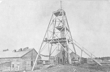
Postcard - GREAT EXTENDED HUSTLERS MINE - POSTCARD OF POPPET LEGS & BUILDINGS
Grey & white postcard showing poppet legs and buildings at the Great Extended Hustlers Mine. Printed on the back: 'Royal Historical Society of Victoria Bendigo Branch. Great Extended Hustlers Locality: Hustlers Hill, Nth. Bendigo Formed 1865 - Last production 1921 Depth of shaft - 3,470 feet Poppet Legs - Steel, 70 feet high Winding Engine: First motion, 8 ft. Drums. Gold Very Rich Total yield - 300,000 oz. Dividends 675,000 Poundsmine, gold, great extended hustlers mine, hustlers hill nth bendigo -
 The Beechworth Burke Museum
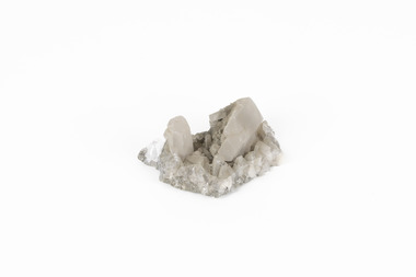
Geological specimen - Calcite crystals
Calcite is a common mineral and is found worldwide due to it being a primary component of many other rocks such as limestone and marble. It is a softer mineral that scratches easily and is often found colourless or with a cream/white shade but may show up in colours such as red, yellow, green, and violet. In sedimentary rocks calcite is often found in the form of invertebrate shells, making it an important biomineral. Calcite is used in many industries such as farming, building, and medicine. This particular specimen was found at Broken Hill mine in Broken Hill, New South Wales, Australia. Broken Hill mine is one of the largest mines working silver and lead in Australia and at its peak employed 6500 staff across 7.5km long of land. The site was founded in 1883 by Charles Rasp, where Rasp and 6 other men from various backgrounds came together to form the first BHP mine. It has become one of the most popular mining sites due to its abundance and longevity. The ore body was created 1685 million years ago due to volcanic activity causing heated seawater to flow up through the seafloor where it mixed with the cold water creating black sulphide precipitates. These then settled back onto the seafloor forming sediment layers rich in minerals. Over time the land eroded until it was discoverable by humans.Historically this specimen is significant due to the origin of its location. Broken Hill mine has a long history in both its location and its findings and has resulted in a variety of minerals being discovered at its site. It is beneficial in the understanding of the Australian landscape over millions of years. Due to its properties, calcite today is used in a multitude of different industries such as agriculture, construction, medicine, and farming.A small sized calcium, carbon and oxygen made mineral specimen in shades cream and greycalcite, mineral, limestone, marble, sedimentary, invertebrate shells, biomineral, farming, medicine, broken hill, broken hill mine, new south wales, charles rasp, syndicate of seven, volcanic activity, black sulphide precipitates, calcite crystals, beechworth museum, indigo shire, beechworth -
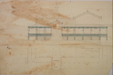
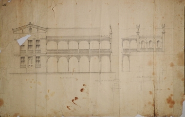
 Clunes Museum
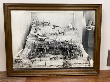
Photograph, PORT PHILLIP MINE MODEL
FRAMED PHOTOGRAPHS OF MODEL OF PORT PHILLIP & CLUNES MINE AND SIGN USED WHEN ON DISPLAY .1 PHOTO OF FULL MODEL .2 PHOTO OF BACK OF MODEL .3 PHOTO OF CLOSE UP OF BUILDING WHICH HAS NO OUTER WALLS OR ROOF TO ENABLE VIEW OF INSIDE. .4 HAND WRITTEN SIGN, FRAMED MODEL MADE IN 1858 BY CARL NORDSTROM ON SITE . MODEL NOW IN STORAGE AT SCIENCE MUSEUM OF VICTORIAlocal history, photographs, mining -
Clunes Museum
Photograph
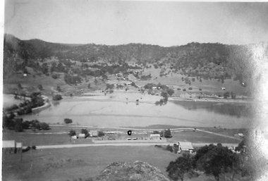
Aerial coloured photo of Clunes, main buildings named and marked with yellow stickers, mines marked with white stickersaerial, clunes mines, john woodland collection -
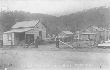
 El Dorado Museum Association Inc.
Photograph (item) - Digital Image
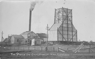
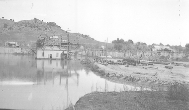
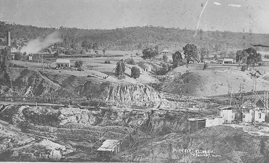
Cocks Pioneer Mine El Dorado, Power Station No. 2 was established in 1914 and located near junction of Reid's and Clear Creeks, Byawatha. Cocks Pioneer Electric Gold & Tin Mine Company was formed in 1899. The company's first power station, located at the eastern end of the valley began operating with its 340 Kilowatt steam-powered generator. By 1909, from 2,500,000 cubic yards worked, reported recovery was 17,284 ounces of gold and 224 tons of tin ore. By 1909, Cocks Pioneer’s power plant had become inadequate and uneconomical. The barge was floated downstream about a mile, but lost time caused the operations to cease. Following testing, a new mine was established by diverting Reid's Creek at a cost of £25,000. Settling dams were built, one of which held 1,935,900 cubic feet. Sold earth banks, built against a wall of stringy bark saplings constructed and laced with vertical props, were built. In 1914, the company was reformed as Cock’s Pioneer Gold and Tin Mines NL, another power station was constructed at the western end of the township, near the junction of Clear and Reid's Creeks. From 6,800,000 cubic yards of material processed, the returns were 64,397 ounces of gold and 855 ton of tin. Cocks Pioneer mine then moved the barge downs stream and continued sluicing. In 1929 Cocks Pioneer Electric Gold and Tin Mining Company ceased operations due to a drop in values. Cock’s Pioneer Gold and Tin Mines NL carried on large-scale hydraulic sluicing operations until 1941. Handwritten on front: 'THE POWER STN COCKS, PIONEER MINE, ELDORADO' / 'THELMA STUDIO / [underlined] WANGARATTA'mining, gold, tin, cocks pioneer, power, sluicing, el dorado, eldorado, byawatha, thelma studios, wangaratta, gold mining, tin mining, reid's creek, clear creek -
 El Dorado Museum Association Inc.
Photograph (item) - Digital Image
Cocks Pioneer Ponds from Monument Hill. Cocks Pioneer Electric Gold & Tin Mine Company was formed in 1899. The company's first power station, located at the eastern end of the valley began operating with its 340 Kilowatt steam-powered generator. By 1909, from 2,500,000 cubic yards worked, reported recovery was 17,284 ounces of gold and 224 tons of tin ore. By 1909, Cocks Pioneer’s power plant had become inadequate and uneconomical. The barge was floated downstream about a mile, but lost time caused the operations to cease. Following testing, a new mine was established by diverting Reid's Creek at a cost of £25,000. Settling dams were built, one of which held 1,935,900 cubic feet. Sold earth banks, built against a wall of stringy bark saplings constructed and laced with vertical props, were built. In 1914, the company was reformed as Cock’s Pioneer Gold and Tin Mines NL, another power station was constructed at the western end of the township, near the junction of Clear and Reid's Creeks. From 6,800,000 cubic yards of material processed, the returns were 64,397 ounces of gold and 855 ton of tin. Cocks Pioneer mine then moved the barge downs stream and continued sluicing. In 1929 Cocks Pioneer Electric Gold and Tin Mining Company ceased operations due to a drop in values. Cock’s Pioneer Gold and Tin Mines NL carried on large-scale hydraulic sluicing operations until 1941. mining, gold, tin, hydraulic, sluicing, gold mining, tin mining, monument hill, cocks pioneer, el dorado, eldorado -
 El Dorado Museum Association Inc.
Photograph (item) - Digital Image
Cocks Pioneer Barge. Cocks Pioneer Electric Gold & Tin Mine Company was formed in 1899. The company's first power station, located at the eastern end of the valley began operating with its 340 Kilowatt steam-powered generator. By 1909, from 2,500,000 cubic yards worked, reported recovery was 17,284 ounces of gold and 224 tons of tin ore. By 1909, Cocks Pioneer’s power plant had become inadequate and uneconomical. The barge was floated downstream about a mile, but lost time caused the operations to cease. Following testing, a new mine was established by diverting Reid's Creek at a cost of £25,000. Settling dams were built, one of which held 1,935,900 cubic feet. Sold earth banks, built against a wall of stringy bark saplings constructed and laced with vertical props, were built. In 1914, the company was reformed as Cock’s Pioneer Gold and Tin Mines NL, another power station was constructed at the western end of the township, near the junction of Clear and Reid's Creeks. From 6,800,000 cubic yards of material processed, the returns were 64,397 ounces of gold and 855 ton of tin. Cocks Pioneer mine then moved the barge downs stream and continued sluicing. In 1929 Cocks Pioneer Electric Gold and Tin Mining Company ceased operations due to a drop in values. Cock’s Pioneer Gold and Tin Mines NL carried on large-scale hydraulic sluicing operations until 1941. mining, gold, tin, barge, sluicing, gold mining, tin mining, cocks pioneer, el dorado, eldorado -
 El Dorado Museum Association Inc.
Photograph (item) - Digital Image
Cocks Pioneer Electric Gold & Tin Mine Company was formed in 1899. The company's first power station, located at the eastern end of the valley began operating with its 340 Kilowatt steam-powered generator. By 1909, from 2,500,000 cubic yards worked, reported recovery was 17,284 ounces of gold and 224 tons of tin ore. By 1909, Cocks Pioneer’s power plant had become inadequate and uneconomical. The barge was floated downstream about a mile, but lost time caused the operations to cease. Following testing, a new mine was established by diverting Reid's Creek at a cost of £25,000. Settling dams were built, one of which held 1,935,900 cubic feet. Sold earth banks, built against a wall of stringy bark saplings constructed and laced with vertical props, were built. In 1914, the company was reformed as Cock’s Pioneer Gold and Tin Mines NL, another power station was constructed at the western end of the township, near the junction of Clear and Reid's Creeks. From 6,800,000 cubic yards of material processed, the returns were 64,397 ounces of gold and 855 ton of tin. Cocks Pioneer mine then moved the barge downs stream and continued sluicing. In 1929 Cocks Pioneer Electric Gold and Tin Mining Company ceased operations due to a drop in values. Cock’s Pioneer Gold and Tin Mines NL carried on large-scale hydraulic sluicing operations until 1941. mining, gold, tin, barge, sluicing, gold mining, tin mining, cocks pioneer, el dorado, eldorado -
 El Dorado Museum Association Inc.
Photograph (item) - Digital Image
Cocks Pioneer Electric Gold & Tin Mine Company was formed in 1899. The company's first power station, located at the eastern end of the valley began operating with its 340 Kilowatt steam-powered generator. By 1909, from 2,500,000 cubic yards worked, reported recovery was 17,284 ounces of gold and 224 tons of tin ore. By 1909, Cocks Pioneer’s power plant had become inadequate and uneconomical. The barge was floated downstream about a mile, but lost time caused the operations to cease. Following testing, a new mine was established by diverting Reid's Creek at a cost of £25 000. Settling dams were built, one of which held 1,935,900 cubic feet. Sold earth banks, built against a wall of stringy bark saplings constructed and laced with vertical props, were built. In 1914, the company was reformed as Cock’s Pioneer Gold and Tin Mines NL, another power station was constructed at the western end of the township, near the junction of Clear and Reid's Creeks. From 6,800,000 cubic yards of material processed, the returns were 64,397 ounces of gold and 855 ton of tin. Cocks Pioneer mine then moved the barge downs stream and continued sluicing. In 1929 Cocks Pioneer Electric Gold and Tin Mining Company ceased operations due to a drop in values. Cock’s Pioneer Gold and Tin Mines NL carried on large-scale hydraulic sluicing operations until 1941. Handwritten across photograph: "PIONEER" - ELDORADO / F FOXCROFT PHOTO.mining, mines, gold, tin, gold mining, tin mining, sluicing, cocks pioneer, el dorado, eldorado -
 El Dorado Museum Association Inc.
Photograph - Digital Image
Cocks Pioneer Office and Milne's horse and cart. Cocks Pioneer Electric Gold & Tin Mine Company was formed in 1899. The company's first power station, located at the eastern end of the valley began operating with its 340 Kilowatt steam-powered generator. By 1909, from 2,500,000 cubic yards worked, reported recovery was 17,284 ounces of gold and 224 tons of tin ore. By 1909, Cocks Pioneer’s power plant had become inadequate and uneconomical. The barge was floated downstream about a mile, but lost time caused the operations to cease. Following testing, a new mine was established by diverting Reid's Creek at a cost of £25 000. Settling dams were built, one of which held 1,935,900 cubic feet. Sold earth banks, built against a wall of stringy bark saplings constructed and laced with vertical props, were built. In 1914, the company was reformed as Cock’s Pioneer Gold and Tin Mines NL, another power station was constructed at the western end of the township, near the junction of Clear and Reid's Creeks. From 6,800,000 cubic yards of material processed, the returns were 64,397 ounces of gold and 855 ton of tin. Cocks Pioneer mine then moved the barge downs stream and continued sluicing. In 1929 Cocks Pioneer Electric Gold and Tin Mining Company ceased operations due to a drop in values. Cock’s Pioneer Gold and Tin Mines NL carried on large-scale hydraulic sluicing operations until 1941. Handwritten on image: COCKS, PIONEER GOLD MINE, ELDORADOmines, mining, horses, cart, transport, gold, tin, gold mining, tin mining, buildings, cocks pioneer, el dorado, eldorado -
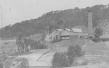 El Dorado Museum Association Inc.
Photograph - Digital Image
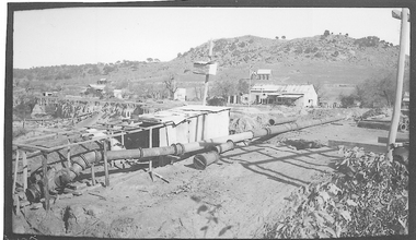
Cocks Pioneer Power Station No 1. Cocks Pioneer Electric Gold & Tin Mine Company was formed in 1899. The company's first power station, located at the eastern end of the valley began operating with its 340 Kilowatt steam-powered generator. By 1909, from 2 500 000 cubic yards worked, reported recovery was 17 284 ounces of gold and 224 tons of tin ore. By 1909, Cocks Pioneer’s power plant had become inadequate and uneconomical. The barge was floated downstream about a mile, but lost time caused the operations to cease. Following testing, a new mine was established by diverting Reid's Creek at a cost of £25 000. Settling dams were built, one of which held 1 935 900 cubic feet. Sold earth banks, built against a wall of stringy bark saplings constructed and laced with vertical props, were built. In 1914, the company was reformed as Cock’s Pioneer Gold and Tin Mines NL, another power station was constructed at the western end of the township, near the junction of Clear and Reid's Creeks. From 6,800,000 cubic yards of material processed, the returns were 64 397 ounces of gold and 855 ton of tin. Cocks Pioneer mine then moved the barge downs stream and continued sluicing. In 1929 Cocks Pioneer Electric Gold and Tin Mining Company ceased operations due to a drop in values. Cock’s Pioneer Gold and Tin Mines NL carried on large-scale hydraulic sluicing operations until 1941. Handrwitten on right side of image: PIONEER MINE ELDORADO Handwritten on left side of image: AJ EVANS PHOTO / WANGARATTAmines, mining, gold, tin, gold mining, tin mining, sluicing, hydraulic mining, energy, power station, cocks pioneer, el dorado, eldorado -
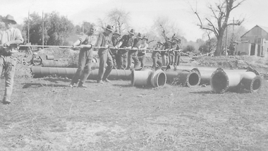 El Dorado Museum Association Inc.
Photograph - Digital Image
Moving Cocks Pioneer Barge, c1930s. Cocks Pioneer Electric Gold & Tin Mine Company was formed in 1899. The company's first power station, located at the eastern end of the valley began operating with its 340 Kilowatt steam-powered generator. By 1909, from 2,500,000 cubic yards worked, reported recovery was 17,284 ounces of gold and 224 tons of tin ore. By 1909, Cocks Pioneer’s power plant had become inadequate and uneconomical. The barge was floated downstream about a mile, but lost time caused the operations to cease. Following testing, a new mine was established by diverting Reid's Creek at a cost of £25,000. Settling dams were built, one of which held 1,935,900 cubic feet. Sold earth banks, built against a wall of stringy bark saplings constructed and laced with vertical props, were built. In 1914, the company was reformed as Cock’s Pioneer Gold and Tin Mines NL, another power station was constructed at the western end of the township, near the junction of Clear and Reid's Creeks. From 6,800,000 cubic yards of material processed, the returns were 64,397 ounces of gold and 855 ton of tin. Cocks Pioneer mine then moved the barge downs stream and continued sluicing. In 1929 Cocks Pioneer Electric Gold and Tin Mining Company ceased operations due to a drop in values. Cock’s Pioneer Gold and Tin Mines NL carried on large-scale hydraulic sluicing operations until 1941. mines, mining, gold, tin, gold mining, tin mining, men, miners, barge, sluicing, hydraulic, cocks pioneer, el dorado, eldorado -
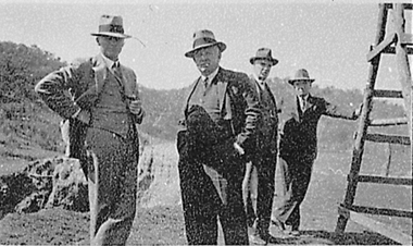 El Dorado Museum Association Inc.
Photograph - Digital Image
Four men touring near the Cock’s Eldorado Gold and Tin Mining Dredge building site. Cropped image from scanned sheet of negative proofs. Cock's El Dorado Gold & Tin Mining Dredge operated between 1936 and 1954. At the time of its construction, the dredge was the largest in the Commonwealth, producing 2,198 kg of gold.mines, mining, gold, gold mining, men, hats, cock's el dorado dredge, dredge, el dorado, eldorado -
 El Dorado Museum Association Inc.
Photograph - Digital Image
McEvoy Miners, c1895.Poster on wall, 'SPORTS' and '£170' only visible textminers, mining, mcevoy mine, men, beards, sports, el dorado, eldorado