Showing 1700 items
matching norman
-
 Bendigo Historical Society Inc.
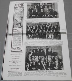
Newspaper - QC Binks collection: The Bendigonian March 10, 1914
BHS CollectionPhotocopies of four pages of The Bendigonian of March 10, 1914, On page thirteen photographs of A.N.A. Eaglehawk branch, St. Liborius branch H.A.C.B.S. Eaglehawk and the refuge tent I.O.R. Eaglehawk. On page fourteen photographs of Sir Alexander Peacock opening the Echuca high school, the Echuca high school situated in Victoria Park, The Echuca girls' hockey team at play at Victoria Park. Also, an article on the silver wedding of Rev. J. Worboys and the golden wedding of his father Mr. T.C. Worboys. On page fifteen photographs of the tennis courts of the Echuca girls' high school, group the kangaroo flat methodist picnic at the botanical gardens, white hills, members of the Y.W.C.A., at the welcome picnic held at the botanical gardens in honor of the return of the secretary (Miss Stevenson). Also, an article on the career of Rev Norman Webster. On page sixteen photographs of the Sandhurst rowing club regatta held on March 4, members of the Sandhurst rowing club taken on the occasion and of a giant watermelon.the bendigonian, 1914, echuca, eaglehawk, sandhurst, rowing club -
 Bendigo Historical Society Inc.
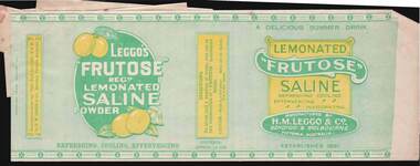
Document - CAMBRIDGE PRESS COLLECTION: LABEL - LEGGO'S FRUTOSE LEMONATED SALINE POWDER
Group of labels which are stuck together. The largest is Lemonated frutose Saline manufactured by H. M. Leggo., Bendigo & Melbourne, Victoria, Australia. It is printed in yellow, dark green and light green. Label has directions how to make a glass of the Saline, the contents Approx. 12 ozs. Established 1881. Another label is Norman J. Oliver, Pharmaceutical Chemist, 288 Hargreaves St, Bendigo. Printed in dark blue. The next one is a red - Caution! - Poison. Not to be Taken Internally. The next one is A. E. Sayer, Pharmaceutical Chemist, 141 Pall Mall, Bendigo, Caution - Poison. Not to be Taken Internally, printed in red. The next is partly obscured. Visible is a circular dark red with white CP and two red and one blue borders and Cambridge Press Bendigo underneath. Beside it is a box with a decorative border with Description printed inside and two writing lines. The last is printed in dark green and is for Skin Cream from A. E. Sayer, Pharmaceutical Chemist, Bendigo.business, printers, cambridge press, cambridge press collection, norman j oliver, a e sayer, h m leggo & co -
 Bendigo Historical Society Inc.
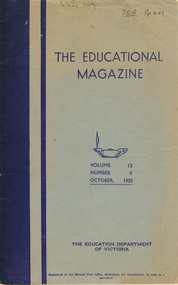
Book - LA TROBE UNIVERSITY BENDIGO COLLECTION: THE EDUCATIONAL MAGAZINE
A blue magazine titled ' The Educational Magazine.' Volume 12 No. 9, 1955. Published by The Education Department of Victoria. This magazine covers a wide variety of educational articles for teachers for general reading. The contents are listed as - The United Nations: tenth birthday; The Disappearance of zoological species by Jean-Paul Harroy; The Brontes and the Yorkshire Moors by Frank Madigan; An Australian looks at America's Schools by Donald McLean; Schools help in battle against poliomyelitis by Hollis A. Moore; Gunpowder, Treason and Plot by D.J.S.; End of a Decade. Ten years at a Provincial Teachers' College by Jessie C. Burnett; Four o'clock and After by various contributors; Mother and Child by anonymous; Clock Watching for a Purpose by K. Norman; Essayist at Work by E.T. Brown, Concerning the Time-Book by E. Elliott; Subtraction in Arithmetic by Carl Petterson; Here's What a Good Teacher Does by Albert J. Phillips; A disabled Children's Young Farmers' Club Project by D. R. Newman and Train up a Child by Alice Downward. 432 pgs. photographsbendigo, education, magazine, la trobe university bendigo collection, collection, bendigo, education, tertiary education, teachers, teaching, reading, magazine, magazine, united nations, literature, brontes, schools, poliomyelitis, disease, diseases, guy fawkes, history, bendigo teachers' college, parenting, female, mother, mothering, women, children, clocks, mathematics, subtraction, disability, young farmers' club, farming, pre-school education, kindergartens, frank madigan, donald mclean, hollis a. moore, d.j.s., jessie c. burnett, k. norman, e.t. brown, e. elliott, carl petterson, albert j. phillips, d. r. newman, alice downward -
 Ballarat Tramway Museum
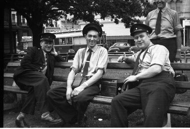
Photograph - Black and White photograph - laminated, Travis Jeffrey, 1959
Photograph of a group of Ballarat Crew or trammies photographed while waiting for their next trams by Travis Jeffery at the City terminus. Has tram No. 25 in the background. Note the padlock tin between the two Connies.Photograph of four Ballarat trammies, crews, on a seat on the north side of Sturt St waiting to go for next trip. From left to right, Norman Lorensini, Ray Curnow, Maurice Shillington, and Ted Edmonds. Has cash tin on seat. In background is tram 25, Commonwealth bank, (old) and the Newsagent kiosk. Taken during 1959. Additional prints made by John Phillips April 1999. 1x 203H x 254W to Marlene Lorensini 4 Duke St. Ballarat, home 53 317 592 for Norms 80th Birthday. Also 1 x 203H x 254W and 89H x 140 Prints for archives. Negative from Travis Jeffrey donated to Museum at same time. 406 large print - 02-02-04 - small print - 1999 - 01-01-57 large print - 01-01-71 - added 20-07-2006 - 278H x 355W Image revised 9/5/2020 from the negative of the photo held.trams, tramways, ballarat, crews, personnel, 25, tram 25 -
 Bendigo Historical Society Inc.
Photograph - Sepia photograph Abbott family group, 1895
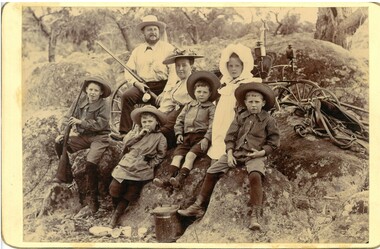
From Abbott Family album (Box 892). A sepia photo taken at Preston Vale of the Abbott family in 1895 including Robert Hartley Smith Abbott (Snr.) Mary Hannah (Gibbs) Abbott and their five oldest children, Robert Hartley Abbott, Inez Marie Abbott, William Norman Abbott, Harold Athelstone Abbott and Kenneth Cyril Abbott. Two of the boys are wearing long sleeved striped collared shirts, one a scouting style coat and the youngest a collared shirt and all boys are in short pants with socks or stockings. Inez, the girl, is in a long sleeved dress with white smock with white bonnet. She is wearing boots. All others are wearing hats, Mrs Abbott's hat has a scrunched/folded ribbon on the brim. She is wearing a long sleeved light coloured blouse fastened at the neck The group is seated on an outcrop of granite rocks with parts of a buggy and horse tackle showing behind them. A lidded billy and scattered cups are on the ground in front. Mr Abbott, in shirt and long pants, is carrying a shot gun as is one of the boys. Both photos have 'Preston Vale Dec 26/95' written in ink on the reverse.abbott family, preston vale -
 Bendigo Historical Society Inc.
Photograph - Sepia photograph Abbott family group, 1895
From Abbott Family album (Box 892). A sepia photo taken at Preston Vale of the Abbott family in 1895 including Robert Hartley Smith Abbott (Snr.) Mary Hannah (Gibbs) Abbott and their five oldest children, Robert Hartley Abbott, Inez Marie Abbott, William Norman Abbott, Harold Athelstone Abbott and Kenneth Cyril Abbott. Two of the boys are wearing long sleeved striped collared shirts, one a scouting style coat and the youngest a collared shirt and all boys are in short pants with socks or stockings. Inez, the girl, is in a long sleeved dress with white smock with white bonnet. She is wearing boots. All others are wearing hats, Mrs Abbott's hat has a scrunched/folded ribbon on the brim. She is wearing a long sleeved light coloured blouse fastened at the neck The group is seated on an outcrop of granite rocks with parts of a buggy and horse tackle showing behind them. A lidded billy and scattered cups are on the ground in front. Mr Abbott, in shirt and long pants, is carrying a shot gun as is one of the boys. Both photos have 'Preston Vale Dec 26/95' written in ink on the reverse.abbott family, preston vale -
 Flagstaff Hill Maritime Museum and Village
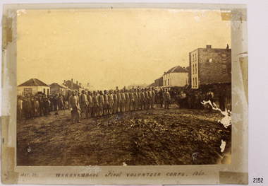
Photograph - Military group, Warrnambool First Volunteer Corps 1860, Taken May 24th, 1860, presented to Mayor in 1887
This Photograph is one of a number of photographs of the Warrnambool Militia. The photograph entitled "Warrnambool First Volunteer Corps" is dated 24th May 1860. (The First Volunteer Corps began in 1855.) It was presented by James Astley Bromfield (former Mayor of Warrnambool) to Major Walter Helpmann, head of Warrnambool’s 1st Volunteer Corps in 1887. The photograph shows the Corps lined up for inspection in Timor Street, Warrnambool. The location is outside what is now the Archie Graham Centre and the camera is looking west towards Liebig Street. The town band is in the right rear corner and spectators surround the Corps. The names listed on the back of the photograph are "1. R.Bushe (Captain in command), 2. Basil Spence, 3. Thomas Mickle, 4. Alfred Davies (Sergeant), 5. Cawthray, 6. Andrew Kerr, 7. Charles Scoborio, 8. Lacy, 9. James Hider, 10. D. O’Mullane, 11. William Norman, 12. Crouthers (or Cowthers ?), 13. Francis Breckon, 14. Russ, 15. Benjamin Wycherley, 16. C. A. Cramer (Sergeant), 17. James Coulstock, 18. Robert Newton (Sergeant), 19. J.A. Bromfield, 20. Singleton (supernumery), 21. Mostyn (Drill Instructor)," On the left of the picture is Billy Adams, Barnes (road contractor) and James Mason (Bootmaker). On the right of the picture is The Band. This is one of a collection of photographs showing the development of the Warrnambool Militia from its inception as the First Volunteer Corps in 1855. The collection is of local significance as it parallels the development of the town and includes images of significant local people. A number of Warrnambool streets are named after members of the Militia. It is also historically significant because of its connection to the unrest that was taking place in Europe at this time. Photograph of Warrnambool First Volunteer Corps 1860, sepia coloured, mounted on cream card. The photograph shows the Corps lined up for inspection in Timor Street Warrnambool. The location is outside what is now the Archie Graham Centre and the camera is looking west towards Liebig Street. The town band is in the right rear corner and spectators surround the Corps. Photograph taken 24th May 1860. Has names listed on reverse side. The protograph was presented to Mayor Helpman, by Bromfield, May 1887. Title printed below base of photo on the mounting board "May. 24. WARRNAMBOOL First VOLUNTEER CORPS. 1860" On the back of the photograph is a numbered list of names, handwritten in ink. Also on the back are presentation details "Presented to Mayor Helpman, by Bromfield, May 1887". warrnambool, wolunteer corps, militia, helpmann, bromfield, flagstaff hill, shipwrecked coast, flagstaff hill maritime museum, maritime museum, shipwreck coast, flagstaff hill maritime village, great ocean road -
 Bendigo Military Museum
Photograph - PHOTOGRAPHS WW1, c. 1915 - 1919
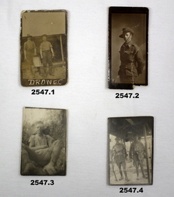
Items relating to the collection re Alexander Norman Cummin No 18, 38th Batt AIF, his brother Harold Nesbit Cummin No 1239 Camel Corp. Refer 2535P (Alexander) 2530.3P (Harold) for their service details. .6) Graves photo. On the left, Sydney Graham Issell. He had 4 years pre war service in Senior cadets and Citizens Forces reaching the rank of Sgt. Enlisted on 8.2.1916 No 912 with the rank of Cpl, C Coy 38th Batt age 21 years 11 months. Embark for England 20.6.1916, promoted L/Sgt, embark for France 22.11.1916, hospital 13.5.1917 (NYD) rejoin unit 19.5.1917, WIA 29.5.1917 GSW chest then restated GSW Back, severe, rejoin unit 12.3.1918, KIA 1.8.1918. On the right, Harold James Fraser. He had 5 years pre war service in the Cadets and Citizens Forces. Enlisted on 27.10.1916 No 2802 6th reinforcements 38th Batt age 22 years. Embark for England 16.12.1916, moves through 10th, 14th Training Batt’s then 66th Batt on 28.4.1917, promoted Sgt and alloted No 2802A, embark for France 25.8.1917 as reinforcement 38th Batt, awarded the Military medal (MM)) 12.10.1917 East of Eypres, KIA 1.8.1918. Both were buried at Vaire Wood near Corbie. .1) 2 Australian soldiers in fatigues with what looks like a cooking apparatus, with letters below DROW EC (stylised). .2) 1/2 length portrait of an Australian soldier. .3) Casual portrait of a soldier sitting in fatigues, probably Sandy. Boots look muddy, scrub in background. .4) Portrait of 2 soldiers (allied) fully armed & wearing helmets. .5) Portrait of a soldier (allied) fully armed & dangerous. .6) Black & white photo of 2 graves with white crosses. Soldiers left cross: No 912 SGT SG ISSELL 38 BN AIF, Soldier right cross: No 2802 SGT HJ FRASER 38 BN AIF. .7) Black & white photo showing 2 Australian soldiers casually dressed in the ruins of an old factory. .8) Black & white mini photo showing building ruins & what appears to be derelict boilers. .9) Black & white mini photo showing what appears to be a WWI German soldier kamerading (surrendering). This is probably posing in captured enemy clothing. 10.) Black & white mini photo showing camels at rest. .11) Black & white mini photo showing a blown up British pattern tank MK1 on sandy terrain. A track has detached & curled up over the front of the tank. .1) verso: “Me & Sandy Port De Nieppe May 1917” .2) verso: “Taken in Liverpool, England while on <> leave Jan 1918. To Mother Father & all at home with love from Sandy”photography-photographs, military history - army, 38th -
 Surrey Hills Historical Society Collection
Photograph, John Gray
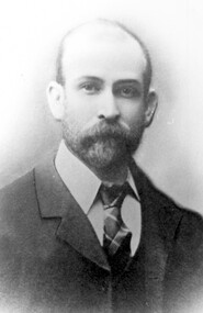
John Gray was "actively associated with all movements for the benefit of neighbours and fellow citizens". [Quote from the official tribute on his death in 1909.] He was very active in the Surrey Hills Progress Association in the early 1900's. The rotunda built in the Surrey Gardens by the Progress Association in 1912 was dedicated to him. John Gray was born in 1861 in Eldorado. He died on 7 December 1909 in Surrey Hills and is buried in Box Hill Cemetery (M0472). He married Emma Beckett in 1888 at 'Guildford Villa' in Essex Road, the Beckett home. They are listed in both the 1903 and 1906 electoral rolls in Arundel Crescent; his occupation is given as bootmaker. The Alan Holt property register identifies this as 24 Arundel Crescent, known as 'Tumberumba'. John and Emma had a large family: (Gunner) John Robert Gray (1888, Surrey Hills - 21 June 1917, France) Benjamin Walter Gray (1890, Surrey Hills - 1949, Heidelberg) Herbert Harry Gray (1892, Surrey Hills - 1959, Queensland) William Beckett Gray (1897, Surrey Hills - 1899, Surrey Hills) Norman Douglas Gray (1901, Surrey Hills - 1947, Sydney) Evelyn Lizzie Gray (1906, Surrey Hills - 1983) Evelyn married Reginald Roberts and was the donor of this photo. Black and white portrait photo of John Gray shows a well-dressed, bearded gentleman with a receeding hairline.surrey hills progress association, surrey gardens, surrey gardens rotunda, john gray, john gray memorial rotunda, arundel crescent, box hill cemetery -
 Melton City Libraries
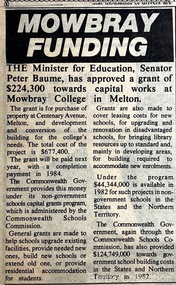
Newspaper, Mowbray Funding, Unknown
" Designed by architect Norman Day, the school was built in an innovative postmodern style. Day’s vision was for the school’s students to feel as comfortable and familiar at school as in their own homes. He based the design on the local suburban typology. The buildings consisted of individual self-contained classrooms, each with a front door, back door and garden. Each class retained the same homeroom for the duration of their schooling. Norman Day won the inaugural Lustig & Moar Architectural Prize in 1988 for his Mowbray College design, and the Australian Library Promotion Council/RAIA Library Design Award for the school’s library building. The school officially opened on 7 February 1983 with an enrolment of 93 students from Prep to Year 7. Mark Fergus was a Prep student in the school’s inaugural year. He later remembered: It was good then because everyone knew each other. Our first few weeks at school we had classes in the Guide Hall because the Mill wasn’t finished. The rest of the school where the Labs and Coppin Court are now was only a big paddock. Another Prep student, Brooke Harrison, recalled: The only recreation we had was the rough playground which consisted of monkey bars, old tractor tyres and a sandpit and high bars. Accidents were a frequent occurrence in those days! It was a friendly atmosphere, you know everyone and their business ... During some classes we used to do horticultural work and planted trees out the front of the school. In 2003, Mowbray College celebrated two decades of educating students in Melton. By that stage, the school had expanded to two campuses with over 1,450 students and 120 staff. It was estimated that over the twenty years since its establishment, 13,000 students passed through the gates. By the mid-2000s, the school offered an International Baccalaureate program and operated across three campuses: the original campus, named Patterson after the first principal, and the Brookside and Town Centre campuses, both located in Caroline Springs. Unfortunately, in 2012 Mowbray College found itself in an unmanageable situation. The community had lost faith in the school’s financial security and as a result some parents withheld their school fees, fearing the school would collapse. It had been in financial difficulty since the mid-2000s and by 2012 was $28 million in debt. 84 In June 2012, all three campuses closed and within four months, each of the campuses of the former Mowbray College had been purchased by other education institutes. Heathdale Christian College bought the original Mowbray campus and established its own campus there and Grace Children’s Services bought the Brookside campus. The Town Centre campus was purchased by Intaj Khan from the Western Institute of Technology but remained vacant after some failed attempts at re-establishing a school. In 2017 the Australian International Academy established an Islamic school on the site".The Express article about a grant for Mowbray Collegeeducation -
 Bendigo Historical Society Inc.
Newspaper - JENNY FOLEY COLLECTION: CLASS OF 1930
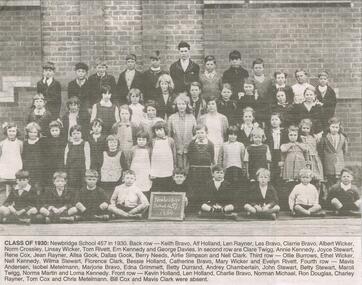
Bendigo Advertiser "The way we were" from Friday, April 22, 2005. Class of 1930: Back row: Keith Bravo, Alf Holland, Len Rayner,Les Bravo, Clarrie Bravo, Albert Wicker, Norm Crossley, Linsay Wicker, Tom Rivett, Ern Kennedy ang George Davies. Second row: Clare Twigg, Annie Kennedy, Joyce Stewart, Rene Cox, Jean Rayner, Allsa Gook, Dallas Gook, Berrie Needs,, Airlie Simpson and Nell Clark. Third row: Ollie Burrows, Ethel Wicker, Nell Kennedy, Wilma Stewart, Florence Clark, Bessie Holland, Catherine Bravo, Mary Wicker and Evelyn Rivett. Fourth row: Mavis Andersen, Isobel Metelmann, Marjorie Bravo, Edna Grimmett, Betty Durrand, Audrey Chamberlain, Jon Stewart, Betty Stewart, Maroli Twigg, Norma Martin and Lorna Kennedy. Front row: Kevin Holland, Len Holland, Charlie Bravo,Norman Michael, Ron Douglas, Charley Rayner, Tom Cox and Chris Metelmann. Bill Cox and Mavis Clark were absent.newspaper, bendigo advertiser, the way we were -
 Bendigo Historical Society Inc.
Newspaper - LYDIA CHANCELLOR COLLECTION: OBITUARIES
Collection of newspaper published obituaries, collected in 1960's. Obituaries mostly from the 'Bendigo Advertiser' and 'The Age' and relate to Bendigo people or those who were born in Bendigo. Index of names attached, with date of publication in newspaper, not date of death. Hamilton, Alexander John 27.4.64 Harvey, Gordon Alan 30.9.64 Hill, Lucy 13.7.63 Hurry, G (Lieut-Colonel) 9.2.51 Jorgensen, Christian 6.6.52 Lee, Norman 10.1.62 Mackay, George 24.5.48 Matchett, Robert 13.5.67 McNeill, Stan 12.6.67 McPherson, John Craig 15.4.66 Mueller, Ernest G 14.9.63 Mumford, Sarah 17.8.32 Mundy,Bert 19.2.63 Murray, Harold 7.2.62 O’Hoy, Que 28.9.64 Pethard, George Albert 22.9.63 Pidgeon, Brian Frederick 28.2.64 Smalley, Johathan 23.8.61 Taylor, Cecil Claude 25.5.69 Trenear, Elizabeth 1916 or 1917 Trengrove, Jack 18.10.62 Turner, Noel 25.9.64 Vicars Foote, R.J 26.9.60 Ward, Charles Edward 20.7.61 Watson, Robert 3.4.62 Weeks, Story M 16.9.67 White, Walter Bolitho 27.4.62 -
Bendigo Historical Society Inc.
Programme - BENDIGO OPERATIC SOCIETY ''SHOE BOAT'' CAPITAL THEATRE FOR SIX NIGHT
Programme of the Bendigo Operatic Society ''Show Boat'' Capital Theatre for six nights Commencing Nov 11th. Music & Lyrics by: Jerome Kern & Oscar Hammerstein II. Producer: Norman Lee. Cast in Order of Appearance: Peter Houston as Windy - Fred Trewarne as Steve Baker - Valerie McCracken as Queenie - Fred Lorenz as Pete - Gertrude Perry as Parthy Ann Hawks - Alfred Annison as Captain Andy Hawks - Annette Wilson as Ellie - Brian Brewer as Frank - Denis Cremin as Rubber-Face - Ruth Iredale as Julie La Verne - Vincent De Araugo as Gaylord Ravenal - Gerald Hayward as Vallon (The Sheriff) - Margaret Rule as Magnolia - Leonard Carr as Joe - George Steele Backwoodsman - Patricia Lyon ad Landlady - James Allen as Jake - Victor White as Max - Robert Nichols as Charlie - Aileen Simmonds as Lottie - Margaret Rule as Kim (Magnolia's Daughter). Synopsis of Story: The play is woven around a romance betweeen Magnolia Hawks and Gaylord Ravenal, and the main scenes are associated with the Show Boat ''The Cotton Blossom'', on the Mississpi in USA.program, theatre, bendigo operatic society -
 Ballarat Heritage Services
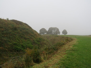
Photograph - Colour, Earth Banks, Old Sarum, England, 2016, 01 November 2016
William the Conqueror inherited Old Sarum from the last Saxon king of England. It was an ideal site for a royal castle. It was here in 1070 that William paid off his army after a long and bitter campaign in northern England. It was here in 1086 that he called together all the major landholders in England so they could swear allegiance to him. It was a crucial moment. The Domesday Book was being written, a threatened Viking invasion had only just been averted and William's eldest son was in armed rebellion. Old Sarum was an important place where this Norman king of England held power. In 1794 the Ordnance Survey set out to check the accuracy of the first mapping of Southern England, which had begun ten years earlier. From a point just below Old Sarum Lieutenant William Mudge laid out a base-line 36,574 feet (11,253 metres) long. From each end of the line the positions of distant places were plotted using a huge theodolite made in 1791 by Jesse Ramsden. The accuracy of the process, which was repeated all over England, depended on Jesse Ramsden's craftsmanship and on William Mudge's surveying skill in setting out this first base-line from Old Sarum. The nearer end of Mudge's line is marked by an inscribed stone beside the modern A345 at Old Sarum. ordnance survey, william mudge, jesse ramsden, william the conqueror, old sarum, saxon, 1086, england -
 Ballarat Heritage Services
Photograph - Colour, Earth Banks, Old Sarum, England, 01 November 2016
William the Conqueror inherited Old Sarum from the last Saxon king of England. It was an ideal site for a royal castle. It was here in 1070 that William paid off his army after a long and bitter campaign in northern England. It was here in 1086 that he called together all the major landholders in England so they could swear allegiance to him. It was a crucial moment. The Domesday Book was being written, a threatened Viking invasion had only just been averted and William's eldest son was in armed rebellion. Old Sarum was an important place where this Norman king of England held power. In 1794 the Ordnance Survey set out to check the accuracy of the first mapping of Southern England, which had begun ten years earlier. From a point just below Old Sarum Lieutenant William Mudge laid out a base-line 36,574 feet (11,253 metres) long. From each end of the line the positions of distant places were plotted using a huge theodolite made in 1791 by Jesse Ramsden. The accuracy of the process, which was repeated all over England, depended on Jesse Ramsden's craftsmanship and on William Mudge's surveying skill in setting out this first base-line from Old Sarum. The nearer end of Mudge's line is marked by an inscribed stone beside the modern A345 at Old Sarum. ordnance survey, william mudge, jesse ramsden, william the conqueror, old sarum, saxon, 1086, england -
 Ballarat Heritage Services
Photograph - Colour, Earth Banks, Old Sarum, England, 2016, 01 November 2016
William the Conqueror inherited Old Sarum from the last Saxon king of England. It was an ideal site for a royal castle. It was here in 1070 that William paid off his army after a long and bitter campaign in northern England. It was here in 1086 that he called together all the major landholders in England so they could swear allegiance to him. It was a crucial moment. The Domesday Book was being written, a threatened Viking invasion had only just been averted and William's eldest son was in armed rebellion. Old Sarum was an important place where this Norman king of England held power. In 1794 the Ordnance Survey set out to check the accuracy of the first mapping of Southern England, which had begun ten years earlier. From a point just below Old Sarum Lieutenant William Mudge laid out a base-line 36,574 feet (11,253 metres) long. From each end of the line the positions of distant places were plotted using a huge theodolite made in 1791 by Jesse Ramsden. The accuracy of the process, which was repeated all over England, depended on Jesse Ramsden's craftsmanship and on William Mudge's surveying skill in setting out this first base-line from Old Sarum. The nearer end of Mudge's line is marked by an inscribed stone beside the modern A345 at Old Sarum. ordnance survey, william mudge, jesse ramsden, william the conqueror, old sarum, saxon, 1086, england -
 Ballarat Heritage Services
Photograph - Colour, Earth Banks, Old Sarum, England, 01 November 2016
William the Conqueror inherited Old Sarum from the last Saxon king of England. It was an ideal site for a royal castle. It was here in 1070 that William paid off his army after a long and bitter campaign in northern England. It was here in 1086 that he called together all the major landholders in England so they could swear allegiance to him. It was a crucial moment. The Domesday Book was being written, a threatened Viking invasion had only just been averted and William's eldest son was in armed rebellion. Old Sarum was an important place where this Norman king of England held power. In 1794 the Ordnance Survey set out to check the accuracy of the first mapping of Southern England, which had begun ten years earlier. From a point just below Old Sarum Lieutenant William Mudge laid out a base-line 36,574 feet (11,253 metres) long. From each end of the line the positions of distant places were plotted using a huge theodolite made in 1791 by Jesse Ramsden. The accuracy of the process, which was repeated all over England, depended on Jesse Ramsden's craftsmanship and on William Mudge's surveying skill in setting out this first base-line from Old Sarum. The nearer end of Mudge's line is marked by an inscribed stone beside the modern A345 at Old Sarum. ordnance survey, william mudge, jesse ramsden, william the conqueror, old sarum, saxon, 1086, england -
 Ballarat Heritage Services
Photograph - Colour, Stonework, Old Sarum, England, English Heritage Site, 01 November 2016
William the Conqueror inherited Old Sarum from the last Saxon king of England. It was an ideal site for a royal castle. It was here in 1070 that William paid off his army after a long and bitter campaign in northern England. It was here in 1086 that he called together all the major landholders in England so they could swear allegiance to him. It was a crucial moment. The Domesday Book was being written, a threatened Viking invasion had only just been averted and William's eldest son was in armed rebellion. Old Sarum was an important place where this Norman king of England held power. In 1794 the Ordnance Survey set out to check the accuracy of the first mapping of Southern England, which had begun ten years earlier. From a point just below Old Sarum Lieutenant William Mudge laid out a base-line 36,574 feet (11,253 metres) long. From each end of the line the positions of distant places were plotted using a huge theodolite made in 1791 by Jesse Ramsden. The accuracy of the process, which was repeated all over England, depended on Jesse Ramsden's craftsmanship and on William Mudge's surveying skill in setting out this first base-line from Old Sarum. The nearer end of Mudge's line is marked by an inscribed stone beside the modern A345 at Old Sarum. ordnance survey, william mudge, jesse ramsden, william the conqueror, old sarum, saxon, 1086, england -
 Ballarat Heritage Services
Photograph - Colour, Stonework, Old Sarum, England, English Heritage Site, 2016, 01 November 2016
William the Conqueror inherited Old Sarum from the last Saxon king of England. It was an ideal site for a royal castle. It was here in 1070 that William paid off his army after a long and bitter campaign in northern England. It was here in 1086 that he called together all the major landholders in England so they could swear allegiance to him. It was a crucial moment. The Domesday Book was being written, a threatened Viking invasion had only just been averted and William's eldest son was in armed rebellion. Old Sarum was an important place where this Norman king of England held power. In 1794 the Ordnance Survey set out to check the accuracy of the first mapping of Southern England, which had begun ten years earlier. From a point just below Old Sarum Lieutenant William Mudge laid out a base-line 36,574 feet (11,253 metres) long. From each end of the line the positions of distant places were plotted using a huge theodolite made in 1791 by Jesse Ramsden. The accuracy of the process, which was repeated all over England, depended on Jesse Ramsden's craftsmanship and on William Mudge's surveying skill in setting out this first base-line from Old Sarum. The nearer end of Mudge's line is marked by an inscribed stone beside the modern A345 at Old Sarum. ordnance survey, william mudge, jesse ramsden, william the conqueror, old sarum, saxon, 1086, england -
 Ballarat Heritage Services
Photograph - Colour, Stonework and well, Old Sarum, England, English Heritage Site, 2016, 01 November 2016
William the Conqueror inherited Old Sarum from the last Saxon king of England. It was an ideal site for a royal castle. It was here in 1070 that William paid off his army after a long and bitter campaign in northern England. It was here in 1086 that he called together all the major landholders in England so they could swear allegiance to him. It was a crucial moment. The Domesday Book was being written, a threatened Viking invasion had only just been averted and William's eldest son was in armed rebellion. Old Sarum was an important place where this Norman king of England held power. In 1794 the Ordnance Survey set out to check the accuracy of the first mapping of Southern England, which had begun ten years earlier. From a point just below Old Sarum Lieutenant William Mudge laid out a base-line 36,574 feet (11,253 metres) long. From each end of the line the positions of distant places were plotted using a huge theodolite made in 1791 by Jesse Ramsden. The accuracy of the process, which was repeated all over England, depended on Jesse Ramsden's craftsmanship and on William Mudge's surveying skill in setting out this first base-line from Old Sarum. The nearer end of Mudge's line is marked by an inscribed stone beside the modern A345 at Old Sarum. ordnance survey, william mudge, jesse ramsden, william the conqueror, old sarum, saxon, 1086, england -
 Ballarat Heritage Services
Photograph - Colour, Stonework, Old Sarum, England, English Heritage Site, 01 November 2016
William the Conqueror inherited Old Sarum from the last Saxon king of England. It was an ideal site for a royal castle. It was here in 1070 that William paid off his army after a long and bitter campaign in northern England. It was here in 1086 that he called together all the major landholders in England so they could swear allegiance to him. It was a crucial moment. The Domesday Book was being written, a threatened Viking invasion had only just been averted and William's eldest son was in armed rebellion. Old Sarum was an important place where this Norman king of England held power. In 1794 the Ordnance Survey set out to check the accuracy of the first mapping of Southern England, which had begun ten years earlier. From a point just below Old Sarum Lieutenant William Mudge laid out a base-line 36,574 feet (11,253 metres) long. From each end of the line the positions of distant places were plotted using a huge theodolite made in 1791 by Jesse Ramsden. The accuracy of the process, which was repeated all over England, depended on Jesse Ramsden's craftsmanship and on William Mudge's surveying skill in setting out this first base-line from Old Sarum. The nearer end of Mudge's line is marked by an inscribed stone beside the modern A345 at Old Sarum. ordnance survey, william mudge, jesse ramsden, william the conqueror, old sarum, saxon, 1086, england -
 Ballarat Heritage Services
Photograph - Colour, Sign Explaining toilets, Old Sarum, England, English Heritage Site, 01/11/2016
William the Conqueror inherited Old Sarum from the last Saxon king of England. It was an ideal site for a royal castle. It was here in 1070 that William paid off his army after a long and bitter campaign in northern England. It was here in 1086 that he called together all the major landholders in England so they could swear allegiance to him. It was a crucial moment. The Domesday Book was being written, a threatened Viking invasion had only just been averted and William's eldest son was in armed rebellion. Old Sarum was an important place where this Norman king of England held power. In 1794 the Ordnance Survey set out to check the accuracy of the first mapping of Southern England, which had begun ten years earlier. From a point just below Old Sarum Lieutenant William Mudge laid out a base-line 36,574 feet (11,253 metres) long. From each end of the line the positions of distant places were plotted using a huge theodolite made in 1791 by Jesse Ramsden. The accuracy of the process, which was repeated all over England, depended on Jesse Ramsden's craftsmanship and on William Mudge's surveying skill in setting out this first base-line from Old Sarum. The nearer end of Mudge's line is marked by an inscribed stone beside the modern A345 at Old Sarum. Colour photograph of a sign explaining toilets at Old Sarum, English Heritage Siteordnance survey, william mudge, jesse ramsden, william the conqueror, old sarum, saxon, 1086,, england -
 Ballarat Heritage Services
Photograph - Colour, Old Sarum, England, 2017, 01 November 2016
William the Conqueror inherited Old Sarum from the last Saxon king of England. It was an ideal site for a royal castle. It was here in 1070 that William paid off his army after a long and bitter campaign in northern England. It was here in 1086 that he called together all the major landholders in England so they could swear allegiance to him. It was a crucial moment. The Domesday Book was being written, a threatened Viking invasion had only just been averted and William's eldest son was in armed rebellion. Old Sarum was an important place where this Norman king of England held power. In 1794 the Ordnance Survey set out to check the accuracy of the first mapping of Southern England, which had begun ten years earlier. From a point just below Old Sarum Lieutenant William Mudge laid out a base-line 36,574 feet (11,253 metres) long. From each end of the line the positions of distant places were plotted using a huge theodolite made in 1791 by Jesse Ramsden. The accuracy of the process, which was repeated all over England, depended on Jesse Ramsden's craftsmanship and on William Mudge's surveying skill in setting out this first base-line from Old Sarum. The nearer end of Mudge's line is marked by an inscribed stone beside the modern A345 at Old Sarum. ordnance survey, william mudge, jesse ramsden, william the conqueror, old sarum, saxon, 1086, england -
 Ballarat Heritage Services
Photograph - Photograph - Colour, Old Sarum, England, 2016, 01/11/2016
William the Conqueror inherited Old Sarum from the last Saxon king of England. It was an ideal site for a royal castle. It was here in 1070 that William paid off his army after a long and bitter campaign in northern England. It was here in 1086 that he called together all the major landholders in England so they could swear allegiance to him. It was a crucial moment. The Domesday Book was being written, a threatened Viking invasion had only just been averted and William's eldest son was in armed rebellion. Old Sarum was an important place where this Norman king of England held power. In 1794 the Ordnance Survey set out to check the accuracy of the first mapping of Southern England, which had begun ten years earlier. From a point just below Old Sarum Lieutenant William Mudge laid out a base-line 36,574 feet (11,253 metres) long. From each end of the line the positions of distant places were plotted using a huge theodolite made in 1791 by Jesse Ramsden. The accuracy of the process, which was repeated all over England, depended on Jesse Ramsden's craftsmanship and on William Mudge's surveying skill in setting out this first base-line from Old Sarum. The nearer end of Mudge's line is marked by an inscribed stone beside the modern A345 at Old Sarum. Colour photograph of Old Sarum, England.ordnance survey, william mudge, jesse ramsden, william the conqueror, old sarum, saxon, 1086, england