Showing 3734 items
matching street map
-
 Bendigo Historical Society Inc.
Map - PLAN SHOWING SURFACE EXTENSIONS OF QUARTZ REEFS
Plan shewing surface extensions of quartz reefs northward from Eaglehawk, Sandhurst. -
Bendigo Historical Society Inc.
Map - GEOLOGICAL MAP BENDIGO GOLD FIELD
... Inc. History House 11 Mackenzie Street Bendigo goldfields ...Geological map Bendigo gold field. Showing anticlines, synclines, shafts, alluvial, contours. Produced by the deprtment of mines. Two originals plus two laminated copies -
 Bendigo Historical Society Inc.
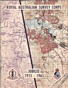
Document - AULSEBROOK COLLECTION: ROYAL AUSTRALIAN SURVEY CORPS JUBILEE 1965, 1965
Aulsebrook Collection: two pamphlets relating to a Jubilee events at the Royal Australian Survey Corps. Title: Royal Australian Survey Corps, Jubilee 1915-1965 (x 2 pamphlets) Two pamphlets for same event, A5, colourful map on the front of the booklet, -First pamphlet is a dinner and wine menu for Jubilee event -Second pamphlet is a information booklet on a brief history of the Corps, and a list of ranks and individuals in the Survey Corps. Booklet also has some photos of Fortuna where the Corps is. -
 Bendigo Historical Society Inc.
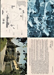
Document - AULSEBROOK COLLECTION: ARMY HEADQUARTERS SURVEY REGIMENT - OPEN DAY PAMPHLET, 1967
Aulsebrook Collection: Military Pamphlet -Army Headquarters Survey Regiment 'Open Day at Fortuna' 12th November,1967. -Fold out to larger A4 -Fold out includes: several pictures of the building and the grounds at Fortuna. Also a welcome statement from the Lieutenant Colonel Commanding Officer and a map with a key. -
 Bendigo Historical Society Inc.
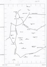
Document - CENTRAL DEBORAH GOLD MINE : GOLDEN SQUARE MINE SITES
Map showing mines in the Golden Square, Diamond Hill area. Roads include Diamond Hill Road, Burns Street, Woodward Road, Belle Vue Road, Houston Street. Latitude and Longitude on map.bendigo, mining, golden square mine sites -
Bendigo Historical Society Inc.
Map - REEF MAP OF BENDIGO
Large coloured map of reefs in Bendigo.bendigo, mining -
Bendigo Historical Society Inc.
Document - NEW MOON MINE RESOURCES AND FUTURE PROSPECTS REPORT
Copy of extract from the Bendigo Advertiser, 22nd November, 1906 spiral bound with plastic cover. On front: 'New Moon Mine Site, its resources and future prospects'. Document contains financial reports, gold extracted, shareholders, battery manager's report, map of leases held by New Moon Co and photos, see below. Photo of Managers of New Moon Co., H.E. Jones Mining Manager, J.C. McCoy Engineer, R.A. Dewar Battery Manager. Photo of directors: Joseph LanFranchi, W.B. Walker, Daniel Murdoch, John Green, Alexander Hay and Edward Bright. Photos include view from base of poppet legs showing tramway and crushing machine, battery and mine, miners at the 1045 level.bendigo, mining, new moon co. nl -
Bendigo Historical Society Inc.
Document - UNDERGROUND SURVEY OF BENDIGO MINES
Two page document, 'Underground survey of Bendigo, report on Constellation Company's Mine on northern extension of the Garden Gully line of reef. Report on the New Chum Railway Reserve Company and the Shenandoah Company, the New Chum Railway Co being immediately south and the Shenandoah Co immediately north of the railway line. Two maps Constellation Co. Mine shaft and New Chum Railway and Shenandoah auriferous reef below 2700 feet.Jems Stirling, geologist and W.H Cundy Underground Surveyor, Department of Minesbendigo, mining, garden gully line of reef mines -
Bendigo Historical Society Inc.
Document - GARDEN GULLY LINE OF REEF, LEASE BLOCKS 5360 AND 5361
Two page document titled ' Report on lease blocks Nos. 5360 and 5361 Garden Gully line of reef, Bendigo. Produced by the Department of Mines 1899. The area described is about 'one mile and a quarter southeast from the centre of the city of Bendigo, immediately south of the Great Southern Gold Mining Company's workings and is intersected by two auriferous gullies ... Salomon's Gully and Derwenter's Gully'. The alluvial deposits, the Garden Gully line, the Great Souther Co.and old workings are discussed in the paper. A map of the Garden Gully line of reef is attached to the report, showing claimholders and mine names along that section of the reef. Mines named on the map: Great Southern Garden Gully United Ulster Londonderry Burrows Horwoods Sea Amalgamated Garden Gully United Victory and Pandora Unity Carlisle and Garden Gully and Passbye United Cornish United Koch's PioneerJames Stirling, Government Geologistbendigo, mining, garden gully line of reef mines -
Bendigo Historical Society Inc.
Document - NEW CHUM LINE OF REEF MUNGO GROUP EAGLEHAWK
Two page document detailing the Mungo Group of Mines along the New Chum line of reef, Eaglehawk. The mines described are: Ellenborough, 2100 feet deep St Mungo, 2,600 feet deep The Lady Barkly, 1,350 feet deep, close to Upper Road with a 40 head battery on the other side. South St Mungo, known as the Governor Barkly in the earlier days. Small map on second page shows the location of the Sadowa shaft, St. Mungo shaft and the Lady Barkly shaft. Victoria Street and Upper Road marked on the map. 'Between Caldwells Road and Victoria Street and Upper Road intersection, nine mines and three crushing batteries worked at one period. All on the New Chum line of reef.' Not signed but most probably written by Albert Richardson.bendigo, mining, mungo group of mines, eaglehawk -
 Bendigo Historical Society Inc.
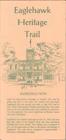
Document - EAGLEHAWK HISTORICAL SOCIETY COLLECTION: EAGLEHAWK HERITAGE TRAIL
Small brochure titled: Eaglehawk Heritage trail, after an introduction a map of the points of interests, few drawing of different buildings, in total the brochure give small information on 33 locations.eaglehawk, history, walking tour -
Bendigo Historical Society Inc.
Book - ANNALS OF BENDIGO 1851 - 1867 VOLUME 1, 1851-1867
Annals of Bendigo 1851 to 1867 (1912) Printed by Mackay & Co. Market Square, Bendigo Includes maps, b/w photographs Grey card cover. Annals of Bendigo 1851 - 1867' written in ink on front cover and on spine. Bendigo Branch Royal Historical Society of Victoria written in ink on bottom RH corner.George Mackay.bendigo, history, annals of bendigo, bendigo, history, annals of bendigo, mining, culture, industry -
Bendigo Historical Society Inc.
Book - KANGAROO FLAT A HISTORY, GOLD, GOATS & PEPPERCORNS, 1993
A 164 page soft cover book 'Kangaroo Flat a History, Gold, Goats & Peppercorns. By David Horsfall. Illustrated with maps and B&W photos. Published in 1993 and printed by Richard Cambridge Printers, Bendigo. Preface by Frank Cusack.David Horsfall -
 Bendigo Historical Society Inc.
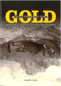
Book - GOLD BLOOD, SWEAT AND FEAR, 2016
352 page soft cover book entitled 'Gold, Blood, Sweat and Fear - Bendigo's Diamond Hill and its Gullies'. Illustrated with B&W and colour photos and maps. Written by James Lerk and dedicated to Ellis Charles Sherwood. Published in 2016 by JA & ERS Lerk. Signed by James A Lerk on title page.James A Lerk -
 Bendigo Historical Society Inc.
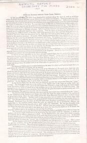
Document - ALBERT RICHARDSON COLLECTION: SECRETARY FOR MINES ANNUAL REPORT 1911
Three page typed report titled ' Notes on diagram showing pitch lines, Bendigo'. Longitudinal sections along the lines of reefs or anticlines within the 8 mile block at Bendigo are shown in a diagram' (diagram not included with notes) Mines and reef lines mentioned in the report are : New Chum line, New Chum Railway mine, Catherine United mine, Hercules and Energetic mine, Garden Gully, Hustlers and Redan, Sheepshead Reef, Sea Mine, Garden Gully, Miller's line of reef and Bendigo Development Mine. The 'old stacks' or chimneys, on Bendigo are described. 'Among the earliest of the stacks built at Bendigo in connexion with Quartz crushing plant, are the two figured in this Annual report No 1 was situate in Sailor's Gully but was demolished about three years ago. This, if not the first, must have been one of the first built, for it had a stone inserted on which chiselled the date 1854. It was built altogether of rough masonry. The other, No. 2, is still standing at the Sheepshead line and was apparently of later date, the upper portion being of brick. They are intersting landmarks of an era that is rapidly passing.' Map attached to report showing location of stacks. Stack at Sailors Gully was near the corner of Murchison Street and Lester Street. The stack at Sheepshead ( Deborah Triangle area) was near the intersection of Belle Vue Road and Adam Street.bendigo, mining, pitch lines bendigo -
 Bendigo Historical Society Inc.
Document - NEVILLE KING COLLECTION: MINISTER'S VISIT TO COLIBAN DISTRICT
Manilla folder titled: Minister's visit to Coliban district on Friday 3rd November, 1967. Inside the itinerary, a map of the Coliban system of waterworks, a one page Coliban water investigation committee invitation to lunch November 3rd, 1967 with all the names of the people invited and a three page report titled ''State rivers and water supply commission Coliban system of waterworks''civil engineering, water supply, coliban -
Bendigo Historical Society Inc.
Book - BENDIGO'S VINTAGE TALKING TRAMS, 1996
100 page soft cover booklet describing the history of the Bendigo tramways. Includes a brief history of Bendigo, illustrated descriptions of the tramways fleet, map of the talking tram route and a script for the tram tour. Edited by Keith S Kings. Published by the Bendigo Trust, December 1996 and printed by Bendigo Modern Press. Signed by Keith Kings 20/2/97 Copy originally owned by RW & M Birrell Inside front cover are 2 tickets for the inaugural tram trip of the restored tram No. 7Keith S Kings -
 Bendigo Historical Society Inc.
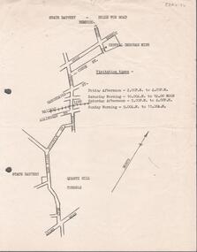
Document - ALBERT RICHARDSON COLLECTION: STATE BATTERY BELLE VUE ROAD, BENDIGO
One page document with map sowing the location of the State Battery Quarry Hill. Visitation times are given, presumably it was a tourist destination.bendigo, mining, state battery -
Bendigo Historical Society Inc.
Book - A BRIEF HISTORY AND REMINISCENCE OF LONG GULLY, 2000
66 page soft cover booklet 'A Brief History and Reminiscence of Long Gully' by George A. Ellis. Printed June 2000 and published by George Ellis. Addendum for page 9 at back cover. Illustrated with B&W photosand map.George A.Ellis -
Bendigo Historical Society Inc.
Book - GOLD ESCORT, 1971
228 page hardcover book by :L.J.Blake entitled 'Gold Escort' The story of how thousands of pounds of gold were sent in escorted wagons from the gold fields at Mt Alexander to South Australia. Emphasis on the Gold Commissioner Alexander Tolmer. Illustrated with B&W photos and maps inside front and back covers. First published and printed 1971 by The Hawthorn Press Pty Ltd.L.J.Blake -
Bendigo Historical Society Inc.
Book - TOURING SACRED MINE SIGHTS OF BENDIGO, 1994
16 page booklet 'Touring Sacred Mine Sights of Bendigo' Produced by Bendigo Mining and the Victorian Chamber of Mines.1994. Researched and written by David Horsfall and printed by Bendigo Modern Press. Details and suggested walking and driving tours of old mine sites. Includes 3 maps.David G Horsfall -
Bendigo Historical Society Inc.
Document - PETER ELLIS COLLECTION: SUBMISSION BY THE BENDIGO FIELD NATURALIST CLUB FOR THE PRESERVATION OF THE WHIPSTICK 1985 OVERHEAD PROJECTOR PRESENTATION, 1985
PETER ELLIS COLLECTION: SUBMISSION BY THE BENDIGO FIELD NATURALIST CLUB FOR THE PRESERVATION OF THE WHIPSTICK 1985 Overhead Projector Presentation Collection of projector overheads, maps and notes.person, individual, peter ellis oam -
 Bendigo Historical Society Inc.
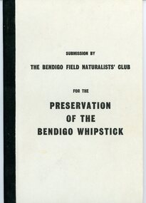
Document - PETER ELLIS COLLECTION: SUBMISSION BY THE BENDIGO FIELD NATURALIST CLUB FOR THE PRESERVATION OF THE WHIPSTICK 1971, 1971
PETER ELLIS COLLECTION: Submission by The Bendigo Field Naturalist Club for the Preservation of the Whipstick Bendigo 1971 The submission was sent to the Minister for Forests. 'On behalf of the Bendigo Field Naturalist's Club, we, the President and Honorary Secretary, make application to the Forests Commission to have two areas, as approximately shown in green on the maps submitted (under separate cover), and being in the parishes of Huntly Nerring and Whirakee, Edgerton declared as Forest Parks under the Appropriate Act.' The Submission has the following contents: Bendigo's Claim for a Forest Park or National Park The Proposed Foiorest Parks Near Bendigo The Flora of The Proposed Whipstick Forest Park Species of Native Plants Bendigo Whipstick Area 1971 Species of Birds Bendigo Whipstick Area 1971 Mammals of the Whipstick Historical Bendigo Whipstick Statisticsperson, individual, peter ellis oam -
 Bendigo Historical Society Inc.
Document - BIG HILL TUNNEL DESCRIPTION
Description of the Big Hill Tunnel, why it was built and David Ogilvie who worked on it with a detailed map of the area.bendigo, planning, big hill tunnel -
Bendigo Historical Society Inc.
Document - STRUCTURE OF BENDIGO GOLDFIELD BULLETIN NO. 47
Booklet, 36 pages, that describes the structure of the Bendigo Goldfield. Booklet is enclosed in an envelope. On front of booklet : 1923 Victoria, Department of Mines, Bulletins of the Geological Survey of Victoria, W. Baragwanath, Director. Structure of Bendigo Goldfield, by H. Herman, late Director of Geological Survey. Maps under catalogue number 3769 accompanied the booklet and are listed as 'plates' on the contents page. Plans and Sections to accompany Bulletin No 47, Structure of Bendigo Gold-Field, by H Herman, B.C.E., M.M.E., F.G.S., late Director of Geological Survey.Geological Survey of Victoriabendigo, gold mining, structure of goldfield, bendigo, goldfield, gold mining, geology -
Bendigo Historical Society Inc.
Map - MAP: VIRGINIA MINE GARDEN GULLY LINE OF REEF
Map of Virginia Mine on the Garden Gully line of reef, Eaglehawk, transverse section. Shaft, levels and Garden Gully anticlinal axial line drawn. Key shows types of formations - quartz, spurs, sandstone, slate, cleavage, lava. This map forms part of the Geological Survey of Victoria, Structure of Bendigo Goldfield report, No. 47, 1923. H.Herman, late Director of Geological Survey.Geological Survey Victoria, Geological Survey Office, Bendigo.bendigo, gold mining, virgina mine eaglehawk, eaglehawk, bendigo, gold mining, virginia mine, garden gully line of reef. -
Bendigo Historical Society Inc.
Map - BENDIGO GOLD FIELD LONGITUDINAL VERTICAL PROJECTIONS
Bendigo gold field map showing vertical projections of portions of three anticlinal axial planes showing stratigraphical zones and caps of known saddle reefs. This map forms part of the Geological Survey of Victoria, Structure of Bendigo Goldfield report, No. 47, 1923. H.Herman, late Director of Geological Survey.Geological Survey Victoriabendigo, gold mining, vertical projections, bendigo, goldfield, gold mining, reef lines, mining companies, geological survey -
 Bendigo Historical Society Inc.
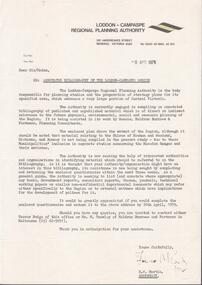
Document - LODDON - CAMPASPE REGIONAL PLANNING AUTHORITY LETTER
Two letters from the Loddon - Campaspe Regional Planning Authority the first dated 9th April, 1979 the second 12th April, 1979 both titled: annotated bibliograpghy of the Loddon-Campaspe Region. Also a map of the Loddon-Campaspe regional Autorithy area of study. Two stapled pages of the Annotated Bibliography of the Loddon - Campaspe Regionorganisation, government, loddon campaspe -
 Bendigo Historical Society Inc.
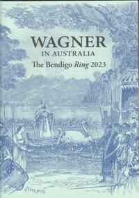
Book - WAGNER IN AUSTRALIA - THE BENDIGO RING 2023, 2023
28 page soft cover booklet entitled 'Wagner in Australia - the Bendigo Ring 2023'. Souvenir booklet to commemorate the performances of 'The Ring Cycle' at the Ulumbarra Theatre, Bendigo by Melbourne Opera. Illustrated with colour and B&W photos and maps. Published by the Melbourne Conservatorium of Music in 2023.The University of Melbourne -
Bendigo Historical Society Inc.
Book - URBAN RENEWAL PROPOSAL BOROUGH OF EAGLEHAWK
16 page spiral bound booklet ' Summary of the Urban Renewal Proposal of the Borough of Eaglehawk, December 1976' Includes proposed plan maps.Urban Renewal Authority, Melbourne