Showing 4478 items
matching the point
-
 Bendigo Historical Society Inc.
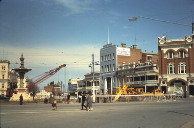
Slide - BENDIGO BUILDINGS, Oct 1964
Slide. Bendigo Buildings. A red crane doing construction work at Charing Cross, between the fountain and cenotaph, with the City Family Hotel on the left, the View Point Hotel, RACV Building, Colonial Mutual Life Building on right.slide, bendigo, bendigo buildings., bendigo buildings. -
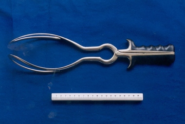 Royal Australian and New Zealand College of Obstetricians & Gynaecologists (RANZCOG)
Barnes-type obstetrical forceps with Simpson style handles, c. 1849-1962, J. Grey & Son, Sheffield, U.K
Neville Barnes obstetric forceps have a cephalic and pelvic curve and are used for delivery of babies presenting as occipitoanterior. The left blade is put on first, followed by the right blade – the baby is then pulled down until the occiput is under the symphysis, then pulled around. This particular set of Barnes forceps is unusual because it has handles/grips associated with Simpson type obstetrical forceps, making it a combination of styles. These forceps are similar in appearance to a style of 19th century forceps known as Hensoldt's forceps, made by Jetter and Scheerer, c. 1899. These are pictured as Fig. 771 in the Sir Kenardatth Das catalogue (see references). J. Gray & Son, Sheffield, were in operation from 1849 to 1962, so these forceps date from this time period.Set of obstetric forceps. Consists of a set of stainless steel blades, with black bakelite hand grip attachment. Forceps are engraved with the text 'J.GREY & SON" and "SHEFFIELD". The number '4' is engraved on the inner aspect of the blade, at the join point.'J.GREY & SON/SHEFFIELD'obstetric delivery -
 Whitehorse Historical Society Inc.
Document, Round Point Peg Co.Pty.Ltd, 1/10/1960 12:00:00 AM
A letter of reference for Frederick Alfred Cottle from the Managing Director of the Round Point Peg Co. Pty. Ltd.A letter of reference for Frederick Alfred Cottle from the Managing Director of the Round Point Peg Co. Pty. Ltd. Frederick, who was the grandfather of Rachael Cottle, lived 1920 - 1993 and moved to 51 Milton Street, Nunawading. A letter of reference for Frederick Alfred Cottle from the Managing Director of the Round Point Peg Co. Pty. Ltd. cottle, frederick alfred -
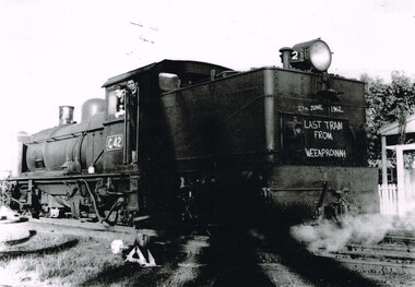 Otway Districts Historical Society
Photograph, Knox Collection, Last train from Weeaproinah, 1962, 27 June 1962
The last goods train ran from Beech Forest and Weeaproinah on Wednesday, 27th June 1962, laden with NQR wagons full of timber and a guard's van. The crew was driver Clarrie Kenyan and fireman John Spence.B/W. 195mm x 267mm. Locomotive G42 bearing the inscription " 27th June 1962, Last train from Weeaproinah" traverses the point, the crew, driver Clarrie Kenyan and fireman John Spence looking at the camera.colac; beech forest; weeaproinah; railways; -
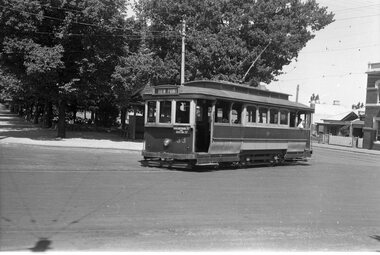 Ballarat Tramway Museum
Negative, Wal Jack, late 1930's or early 1940's
Yields information about the Ripon and Sturt St junction and tram services.Negative and Digital image of the Wal Jack Ballarat Negative file of No. 33 turning from Sturt St into Ripon St, on its way to View Point. Has an auxiliary board of "Macarthur St via Ripon St" trams, tramways, sturt st, view point, ripon st, tram 33 -
Bendigo Historical Society Inc.
Book - ST. JUST'S POINT, 1990
72 page soft cover booklet - St. Just's Point, Down to Earth Cornish Humour. Comic strip cartoons of Cornish characters By Ian Glanville and signed by the author Published 1990 and printed at Sloans Printery , BendigoIan Glanville -
 Kew Historical Society Inc
Photograph - Flooding of the Yarra Valley at Kew East, 1974
Flooding of the Yarra Valley, including that section of the Yarra bordering Kew and Kew East in the north and west of the municipality, was a regular occurrence. Extreme flood events of the Yarra River are recorded to have occurred in 1891, 1901, 1916, 1923 and 1934. The Municipality of Kew's response to these floods was to enact planning decisions restricting residential development in flood prone areas following the floods of 1916, 1921 and 1934. While floods continued after the development of the Upper Yarra Reservoir (construction 1948-57), the regularity and extent of these inundations diminished. During the nineteenth century, the land abutting the south side of the Yarra in Kew was devoted to dairy farming. In the twentieth century, before and after the construction of the Eastern Freeway, much of this low-lying area was used as golf courses and public parks.Late example of the capacity of the Yarra Valley at Kew to flood, even though drainage works and the Upper Yarra Reservoir had reduced their regularity.Original black and white print photograph of Hay's Paddock under floodwater on 16 May 1974. The vantage point of the photographer is Keystone Crescent looking east. Flooding was caused by overflowing water in Glass' Creek and the River Yarra. Annotation verso: "Keystone Cr looking east / 16 May 1974 11.50am"hays paddock, floods, yarra river, glass' creek -
 University of Melbourne, Burnley Campus Archives
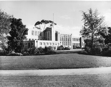
Photograph - Black and white print, Publicity Branch Victorian Department of Agriculture, Administration Building, 1958
Note by T.H. Kneen 19 November 1991, "The Ginkgo biloba died subsequently and was replaced by another tree in the same area. The replacement is a Liriodendron tulipifera planted by the Minister for Agriculture Mr Kent on Arbor Day 1982. (This tree has been replaced by a G. biloba twice more in slightly different places).4 copies black and white photograph. East side of building viewed from South East point across lawns. Prominent tree at right is Ginkgo biloba. Also small print taken from large photo.On reverse, "Received at Burnley March 1958," and, "Photograph by Publicity Branch Victorian Department of Agriculture Ref. No. B1418."lawns, trees, ginkgo biloba, minister for agriculture, arbor day, 1982, minister for agriculture mr kent, administration building, main building, emily gibson beds, liriodendron tulipifera -
 Mont De Lancey
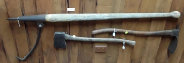
Tool - Cant Hook, Unknown
A long wooden handled tool which has a shaped knob at the end. It has a steel point at the other end with a large curved hook casing, attached underneath with a metal bolt. It was used to roll heavy logs or bags.hooks, tools, farm equipment, grappling irons -
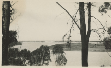
 Lakes Entrance Historical Society
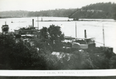
Photograph - New Works Jetty, 1910c
Also second black and white copy 9 x 13 cmBlack and white photograph showing lakes and boats at new Works Wharf. Some groyne work on Bullock Island on right, road cutting on Jemmys Point on right, Kalimna and Nungurner hills in background. Lakes Entrance VictoriaExcursion Boats, New Works Lakes Entrancejetties, waterways, boats and boating, topography -
 Lakes Entrance Historical Society
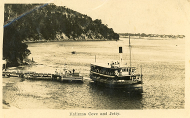
Postcard - Kalimna Jetty, 1925 c
Second copy enlarged, black and white 16 x 25 cmBlack and white postcard showing S S Gippsland leaving Kalimna Jetty, Jemmys point in background, hummocks in distance, several people on jetty, small boat in distance, man on rocks fishing. Lakes Entrance VictoriaKalimna Cove and Jettyships and shipping, waterways -
 Lakes Entrance Historical Society
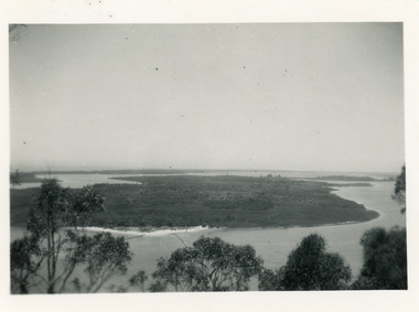
Photograph - Rigby Island, 1930c
Second copy similar viewBlack and white photograph of Rigby Island, Gippsland Lakes Victoria. It shows Reeves Channel on right of photo, Hopetoun Channel on left, The Narrows below Jemmys Point from which photo was taken. Lakes Entrance Victoriaislands, waterways, topography -
 Lakes Entrance Historical Society
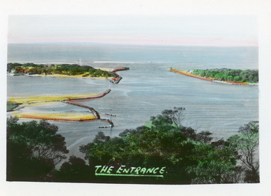
Postcard - The Entrance, Bulmer H D, 1940c
Hand tinted small format postcard of the entrance to the Gippsland Lakes, taken from Jemmys Point. It shows the rock groynes at Bullock Island with dredged sand filling the basin between island and groyne. Lakes Entrance VictoriaThe Entranceislands, waterways, topography -
 Lakes Entrance Historical Society
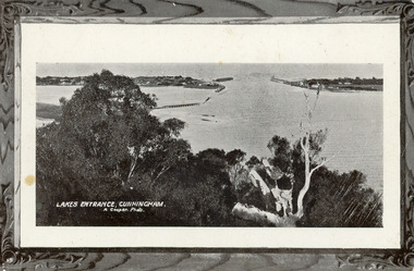
Postcard - The Entrance, 1905c
Message on back of card, to 'Misses M & A Henderson, Swan Reach, Just a line to wish ......, Yours sincerely, R J Gilsenan.'Black and white postcard of the man made entrance. It shows the works building and cottages on each side of the entrance, timber cribs and rock groynes at Bullock Island, natural vegetation of Jemmys Point in foreground. Lakes Entrance VictoriaLakes Entrance, Cunningham topography, waterways, correspondence -
 Lakes Entrance Historical Society
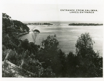
Postcard - The Entrance, 1935c
Also 2 identical small format postcardsBlack and white small format postcard taken from the cliff top at Kalimna. It shows the man made entrance through the hummocks, rock groynes, Jemmys Point cliff and natural vegetation in foreground. Lakes Entrance VictoriaEntrance from Kalimna, Lakes Entrance waterways, topography -
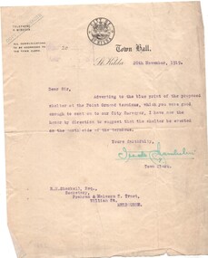 Melbourne Tram Museum
Letter, City of St Kilda, shelter shed on the corner of St Kilda Road and High St, 20/11/1919 12:00:00 AM
Letter - City of St Kilda - dated 20/11/1919, to the Secretary of the Prahran and Malvern Tramways Trust Mr. R. Shackell regarding the shelter location at the Point Ormond terminus - suggesting being placed on the north side.trams, tramways, pmtt, letters, city of st kilda, point ormond, shelters -
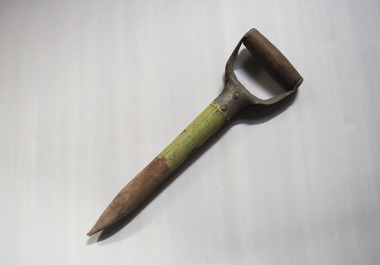 University of Melbourne, Burnley Campus Archives
Tool - Garden tool, Dibber
Short tool used to make holes in the ground for planting. Made from a repurposed wooden and metal handle for another tool like a spade. Metal parts screwed to the wood. The end shaved to a point. Painted light green.garden tools, horticulture, students, burnley college -
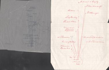 Bendigo Historical Society Inc.
Map - SNOB'S HILL - PLAN OF SNOB'S HILL AREA
Plan drawn on tracing film of sand heap, dams, trig point and mines. Some un-named streets are also drawn in. Piece of notepaper has mines drawn in on a larger scale. Notes prepared by Albert Richardson.map, bendigo, goldfields, snob's hill, plan of snob's hill area, new st mungo mullock heap, duchess trib, s devonshire, duchess of edinburough, w u devonshire, hopewell, phoenix, unicorn, princess alice, lady barkly, sadowa, e u devonshire, united devonshire, l?, ellenborough, belmont & saxby, snob's hill -
 Lakes Entrance Historical Society
Postcard, Bulmer, Scene from Jemmys Point, 1900 c
Black and white postcard showing view from Jemmys Point of east end of Rigby Island and Reeves channel the entrance and sand dunes with Hope channel in distance Lakes Entrance Victoria.Also another copy of same postcard township, waterways, islands -
 Chelsea & District Historical Society Inc
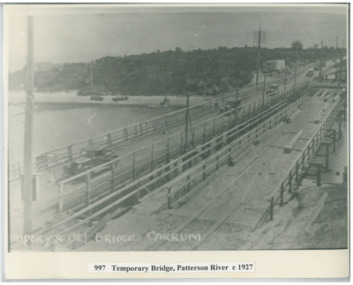
Photograph - Patterson River, Temporary and Old Bridge, c 1927
The first bridge over the river was built in the early 1880's, prior to this it was a pontoon bridge. In 1927 the construction of a concrete bridge was undertaken.Black and white photo of the old wooden road bridge (Point Nepean / Nepean Highway), and a temporary bridge over Patterson River, Carrum near the mouth of the river. Cars using the old bridge. Rowing boats on shore. Temporary and old bridge, Carrumpatterson river, road bridge, rail bridge, chelsea, transport, patterson river bridge, carrum bridge, temporary bridge, cars -
 Lakes Entrance Historical Society
Photograph, Carpenter, Scarborough Hotel Metung Victoria, 1950 c
Black and white photograph of old Scarborough Hotel and partt of wharf showing the trolly on the wharf at Metung Victoria. Also a black and white photograph showing boat at end of Metung wharf and crane looking towards Shaving Point roads and streets, waterways -
Federation University Historical Collection
Book, Northern Territory of South Australia Report Resulting from the Explorations by the Government Geologist, 1906, 1906
Pale blue soft covered geological and general report. It includes a chapter of Bathurst Island and Melville Island, Primitive Methhods of Chinese Mining, Early Days of Mining in the Northern Territory Images include sandbank at low tide, Douglas River, Granite at Union Hill, Night Cliff, East Point, union hill, zapopan gold mine Brook's Creek, Blow Gold Mine Yam Creek, Daly River Copper Mine, Mount Ellison Copper Mine, Point Charles Lighthouse, Blacks Camp near Point Charles Lighthouse, The Venture Stranded on a Daly River Sandbank, Hyland Bay Natives, Boabab Trees at Blunder Bay, The Wai Hoi, Mouth of Fitzmaurice River, Point Blaze Natives, Fort Hill and Old Gulnare Jetty Port Darwin, Large Anthill, Daly RIver Natives, Wargie Natives, L.C.E. Gee, H.Y.L. Brown, H. Basedow. F.J. Williamson, Aboriginal crew (Pedro, Peter, Tobatchie, Bubs, Loman), Henry Roberts, Schollert's Grave It also includes a large folder Geological Map of the North-Western District Northern Territory of South Australia. northern territory of south australia, geology, l. o'loughlin, douglas river, bathurst island, melville island, apsley straight, chinese, aboriginal -
 Flagstaff Hill Maritime Museum and Village
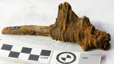
Nail, 1855
The artefact is the lower portion of a rectangular shanked ‘planking nail’ with a straight-edged ‘flat point’. The distinctive ‘point’ of a planking/skirting nail was designed to be driven into timber across the grain in order to prevent the wood from splitting. This relic is from the shipwreck of the SCHOMBERG, which ran aground near Peterborough in 1855. It was retrieved in 1875 from a large section of the ship’s bow which had been carried by ocean currents to the western coast of New Zealand’s South Island. The nail is still fixed in a fragment of the original timber that it secured in the SCHOMBERG. The top portion, or ‘head’ of the nail, has corroded away but the pronounced rectangular shank and its flat point indicate its likely purpose and position on the vessel. Most fastenings used in sailing ship construction were either wooden treenails or copper bolts, which were relatively resistant to seawater corrosion. In addition, the preferred hull-frame timber of British Oak has a high content of gallic acid which rapidly corrodes unprotected iron work. The ferrous composition of this planking nail suggests it came from an internal and upper portion of the ship’s bow (protected from exposure to the sea or oak). According to an 1855 edition of the Aberdeen Journal, the five outer layers, or ‘skins’, of the SCHOMBERG’s pine hull were “combined by means of patent screw treenails”. However the “beams of her two upper decks” were of “malleable iron”, and “part of the forecastle” was “fitted for the accommodation of the crew”. It is therefore possible that iron nails of this description were used by the ship’s builders to secure floor and wall planks in enclosed areas of the crew’s quarters. (The same reasoning would apply to officer and passenger accommodation amidships and at the stern of the vessel, but it was the bow that floated to New.Zealand.) The SCHOMBERG was a 2,000 ton clipper ship, specifically designed for the Australian immigration trade (back-loading wool for Britain’s mills), and constructed in Hall’s shipyard in Aberdeen, Scotland. She was owned by the Black Ball Line and launched in 1855. Alexander Hall & Son were renowned builders of sleek and fast 1,000 ton clippers for the China trade (opium in, tea out) and were keen to show they could also outclass the big North American ships built by Donald Mackay. Consequently the SCHOMBERG was ‘overbuilt’. Her hull featured five ‘skins’ of Scotch Larch and Pitch Pine overlaying each other in a diagonal pattern against a stout frame of British Oak. Oak has been favoured by builders of wooden ships for centuries. Its close, dense grain made it harder to work, but also gave it great strength and durability. In addition, the lateral spread of its branches supplied a natural curvature for the ribs of a vessel’s hull, as well as providing the small corner or curved pieces (‘knees’ and ‘elbows’) that fit them together. At the launch the SCHOMBERG’s 34 year old master, Captain ‘Bully’ Forbes, had promised Melbourne in 60 days, "with or without the help of God." James Nicol Forbes was born in Aberdeen in 1821 and rose to fame with his record-breaking voyages on the famous Black Ball Line ships; MARCO POLO and LIGHTNING. In 1852 in the MARCO POLO he made the record passage from London to Melbourne in 68 days. There were 53 deaths on the voyage but the great news was of the record passage by the master. In 1954 Captain Forbes took the clipper LIGHTNING to Melbourne in 76 days and back in 63 days, this was never beaten by a sailing ship. He often drove his crew and ship to breaking point to beat his own records. He cared little for the comfort of the passengers. On this, the SCHOMBERG’s maiden voyage, he was going to break records. SCHOMBERG departed Liverpool on her maiden voyage on 6 October 1855 flying the sign “Sixty Days to Melbourne”. She departed with 430 passengers and 3000 tons cargo including iron rails and equipment intended to build the Melbourne to Geelong Railway and a bridge over the Yarra from Melbourne to Hawthorn. She also carried a cow for fresh milk, pens for fowls and pigs, 90,000 gallons of water for washing and drinking. It also carried 17,000 letters and 31,800 newspapers. The ship and cargo was insured for $300,000, a fortune for the time. The winds were poor as she sailed across the equator, slowing SCHOMBERG’s journey considerably. Land was first sighted on Christmas Day, at Cape Bridgewater near Portland, and Captain Forbes followed the coastline towards Melbourne. Forbes was said to be playing cards when called by the Third Mate Henry Keen, who reported land about 3 miles off, Due in large part to the captain's regarding a card game as more important than his ship, it eventually ran aground on a sand spit near Curdie's Inlet (about 56 km west of Cape Otway) on 26 December 1855, 78 days after leaving Liverpool. The sand spit and the currents were not marked on Forbes’s map. Overnight, the crew launched a lifeboat to find a safe place to land the ship’s passengers. The scouting party returned to SCHOMBERG and advised Forbes that it was best to wait until morning because the rough seas could easily overturn the small lifeboats. The ship’s Chief Officer spotted SS QUEEN at dawn and signalled the steamer. The master of the SS QUEEN approached the stranded vessel and all of SCHOMBERG’s passengers and crew were able to disembark safely. The SCHOMBERG was lost and with her, Forbes’ reputation. The Black Ball Line’s Melbourne agent sent a steamer to retrieve the passengers’ baggage from the SCHOMBERG. Other steamers helped unload her cargo until the weather changed and prevented the salvage teams from accessing the ship. Later one plunderer found a case of Wellington boots, but alas, all were for the left foot! Local merchants Manifold & Bostock bought the wreck and cargo, but did not attempt to salvage the cargo still on board the ship. They eventually sold it on to a Melbourne businessman and two seafarers. In 1864 after two of the men drowned when they tried to reach SCHOMBERG, salvage efforts were abandoned. Parts of the SCHOMBERG were washed ashore on the south island of New Zealand in 1870, nearly 15 years after the wreck. The wreck now lies in almost 9 metres of water. Although the woodwork is mostly disintegrated the shape of the ship can still be seen due to the remaining railway irons, girders and the ship’s frame. A variety of goods and materials can be seen scattered about nearby. Flagstaff Hill holds many items salvaged from the SCHOMBERG including a ciborium (in which a diamond ring was concealed), communion set, ship fittings and equipment, personal effects, a lithograph, tickets and photograph from the SCHOMBERG. One of the SCHOMBERG bells is in the Warrnambool Library. This nail is a registered artefact from the wreck of the SCHOMBERG, Artefact Reg No S/35 and is significant because of its association with the SCHOMBERG. The SCHOMBERG collection as a whole is of historical and archaeological significance at a State level, listed on the Victorian Heritage Register VHR S612. Flagstaff Hill’s collection of artefacts from the SCHOMBERG is significant for its association with the Victorian Heritage Registered shipwreck. The collection is primarily significant because of the relationship between the objects, as together they have a high potential to interpret the story of the SCHOMBERG. The SCHOMBERG collection is archaeologically significant as the remains of an international passenger ship. The shipwreck collection is historically significant for representing aspects of Victoria’s shipping history and its potential to interpret sub-theme 1.5 of Victoria’s Framework of Historical Themes (living with natural processes). The collection is also historically significant for its association with the shipwreck and the ship, which was designed to be fastest and most luxurious of its day. The SCHOMBERG collection meets the following criteria for assessment: Criterion A: Importance to the course, or pattern, of Victoria’s cultural history. Criterion B: Possession of uncommon, rare or endangered aspects of Victoria’s cultural history. Criterion C: Potential to yield information that will contribute to an understanding of Victoria’s cultural history. The object is the bottom end of a slightly curved iron planking nail with remnant of timber still attached, recovered from the wreck of the SCHOMBERG (1855). The shank of the nail is rectangular and it narrows to a flat (chisel like) ‘point’. The ‘head’ is missing although there is a quantity of dark red corrosion within the top of the surrounding wood, suggesting where it might have been. The artefact is from the wreck of the SCHOMBERG (1855) and was retrieved from part of the ship’s bow which was carried by sea currents to the South Island of New Zealand. flagstaff hill, warrnambool, shipwrecked-coast, flagstaff-hill-maritime-museum, maritime-museum, shipwreck-coast, flagstaff-hill-maritime-village, schomberg, planking nail, rectangular ship’s nail, cast iron nail -
 Greensborough Historical Society
Article, Book, Shire of Diamond Valley, Kangaroo Point, excerpt from Diamond Valley Story, 1979_
References to "Kangaroo Point" taken from The Diamond Valley Story by Dianne H. Edwards, pages 31-32, 97, 109. 4 photocopied pages. kangaroo point -
 Greensborough Historical Society
Article, Bruce G. Draper, The Batman Apple Tree: Victoria's oldest apple tree? by Bruce G. Draper, 1839o
Account of evidence pointing to the origin of an apple tree in Greensborough that may have been planted by John Batman, who died in 18394 p., typescript.batman apple tree -
 Friends of Kurth Kiln
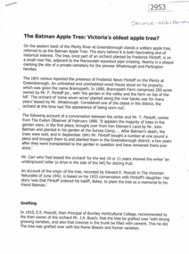
Assembly,mid 1940
Kurth's kiln used creek water in a series of waterpipes to cool the charcoal below the flash point for extraction during the charing processA cylinder of wood fitted on a 1" waterpipe, secured by an elbow and a 1" locknut. A 10cl long piece of pipe is fitted on the other side of the elbow. The assembly could be part of the kiln water-cooling system -
 National Wool Museum
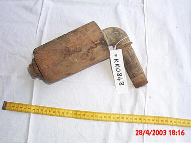
Book
Ledger from the Mount Fyans station, property of William Cumming, Mount Fyans, and Thomas F Cumming, Stony Point, Victoria.LEDGERshearing sheep stations - management, cumming, mr w. b., mount fyans stud, victoria, shearing, sheep stations - management -
 Nepean Historical Society
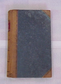
Photograph, Watson’s Fishing Camp, Sorrento
John Watson moved his fishing camp to this site after he was paid by the Department of Defence to leave Point Franklin in 1880.Watson's fishing camp situated where the present club houses of the Sorrento sailing Club now stand. Donated by V. Keatingjohn watson, fishing, sscbc, sorrento sailing club -
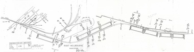 Port Melbourne Historical & Preservation Society
Plan - Victorian Railways 'single line diagram 'Port Store', Victorian Railways, Nov 1942
Diagrams created by the Victorian Railways with detailed information including weight of rails, distance of points/switches from the datum point, etc.Scanned copy of 'single line diagram' for 'Port Store'victorian railways, port store -
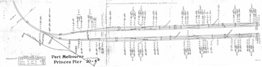 Port Melbourne Historical & Preservation Society
Plan - Victorian Railways 'single line diagram 'Princes Pier', Victorian Railways, Oct 1954
Diagrams created by the Victorian Railways with detailed information including weight of rails, distance of points/switches from the datum point, etc.Scanned copy of 'single line diagram' for 'Princes Pier'victorian railways, piers and wharves - princes pier