Showing 1265 items
matching yarra falls
-
 Mt Dandenong & District Historical Society Inc.... Community Hall 42 Falls Road Mt Dandenong yarra-valley ...
 -
 Mt Dandenong & District Historical Society Inc.... Community Hall 42 Falls Road Mt Dandenong yarra-valley ...
 -
 Mt Dandenong & District Historical Society Inc.... Community Hall 42 Falls Road Mt Dandenong yarra-valley ...
 -
 Mt Dandenong & District Historical Society Inc.... Community Hall 42 Falls Road Mt Dandenong yarra-valley ...
 -
 Mt Dandenong & District Historical Society Inc.... Community Hall 42 Falls Road Mt Dandenong yarra-valley ...
 -
 Mt Dandenong & District Historical Society Inc.... Community Hall 42 Falls Road Mt Dandenong yarra-valley ...
 -
 Mt Dandenong & District Historical Society Inc.... Community Hall 42 Falls Road Mt Dandenong yarra-valley ...
 -
 Mt Dandenong & District Historical Society Inc.... Community Hall 42 Falls Road Mt Dandenong yarra-valley ...
 -
 Mt Dandenong & District Historical Society Inc.... Community Hall 42 Falls Road Mt Dandenong yarra-valley ...
 -
 Mt Dandenong & District Historical Society Inc.
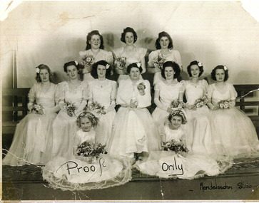
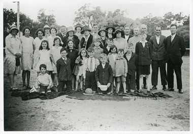
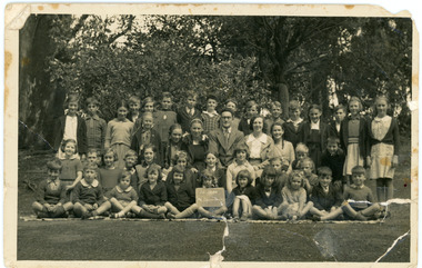
Photograph, Mt Dandenong School c1938
... Community Hall 42 Falls Road Mt Dandenong yarra-valley ...Full school photograph c1938 showing 43 pupils with Head Teacher Mr. M. F. Morris and Sewing Teacher (female).Official School photograph of Mt Dandenong State School No. 3284 showing 43 pupils and two teachers.mt dandenong school, mt dandenong state school, m. f. morris, morris, head teacher, school -
 Southern Sherbrooke Historical Society Inc.
Information folder - Charles Hammond
Photocopies of watercolours reproduced in book "Charlie Hammond's Sketchbook", showing scenes in the Dandenong Ranges, early 1900s. -article, "Library gains a colonial treasure", Age, 17 July 1987, 2 copies, re. acquisition of Hammond sketchbooks by State Library of Victoria -photocopy of first two pages from book, Charles Hammond's Sketch-book.dandenong ranges, bushfires, belgrave, tecoma, puffing billy, coles nursery, nathania springs, sherbrooke falls, dandenong reservoir -
Southern Sherbrooke Historical Society Inc.
Map - photocopy, Woodcock & McCormack, civil engineers & architects & surveyors, The Major Estate, Belgrave
A photocopy taken from the original land sale map provided to the society through Karel Coxell of Stockdale & Leggo. The original maps are stored in large bound account books and were originally the propert of McNally Real Estate. The books are held (in 22 A3 sheets. Shows The Serpentine between Government Rd (now Sandells Rd) and Government Rd(now Terrys Ave), Belgrave. Arrows to Belgrave, Sherbrooke Falls, Main Rd and store.land sales, advertisement, real estate subdivision, t. mahoney -
 Southern Sherbrooke Historical Society Inc.
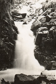
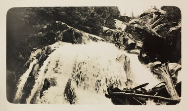
Postcard, Sherbrooke Falls
Sepia-toned postcard featuring Sherbrooke Falls running heavily. Rocks at side of Falls. -
 Southern Sherbrooke Historical Society Inc.
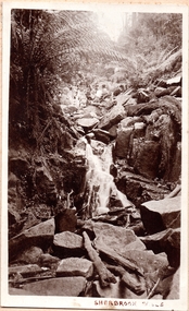
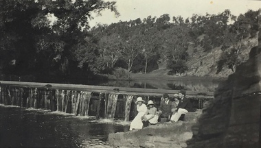
Photograph, Sherbrooke Falls
Photo of the falls in Sherbrooke Forest. Huge amount of large rocks in and around creek bed. Ferns grow up sides of banks. Low volume of water indicates dry season. At the top of the falls a man sits with another person who appears to be a woman. c.1920. -
 Southern Sherbrooke Historical Society Inc.
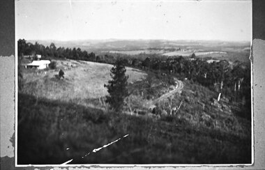
Photograph - Puffing Billy line near The Tanks
B&W photo of the Puffing Billy line near The Tanks below Glen Park Farm. On the left is the house of the Dunham family, with shedding in the background. The land slopes down to the track then falls quite steeply away to a treed area. In the distance can be seen land which is now part of Cardinia Reservoir. -
 Kew Historical Society Inc
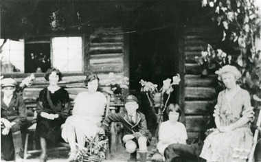
Photograph, Richardson Family at Dight's Falls, 1920
Dight’s Falls in Studley Park is an artificial weir built on a natural rock bar across the Yarra. The weir was built in the 1840s to provide water to the ‘Ceres’ flour-mill, one of the first in Victoria. The falls were later to become known as Dight’s Falls after the owners of the mill. Later, a pumping station was built on the Kew side of the river, which pumped water uphill to a reservoir in Walmer Street that provided water to the Melbourne Botanical Gardens and to Albert Park Lake. The area around Dight’s Falls was and is frequently used for recreational activities.This photograph forms part of the collection assembled by the historian Dorothy Rogers, that was donated to the Kew Historical Society by her son John Rogers in 2015. The manuscripts, photographs, maps, and documents were sourced by her from both family and local collections or produced as references for her print publications. Many were directly used by Rogers in writing ‘Lovely Old Homes of Kew’ (1961) and 'A History of Kew' (1973), or the numerous articles on local history that she produced for suburban newspapers. Most of the photographs in the collection include detailed annotations in her hand. The Rogers Collection provides a comprehensive insight into the working habits of a historian in the 1960s and 1970s. Together it forms the largest privately-donated collection within the archives of the Kew Historical Society.Black and white photograph of the Richardson family seated on the Kew side of Dight's Falls in 1920. One of the girls in the photograph was to become the Melbourne historian Dorothy (Richardson) Rogers.Annotation on reverse: "Mrs D. Rogers, 29 Park Crst Kew. Dights Falls 1920"dight's falls - kew (vic) - fairfield (vic), sport and recreation - kew (vic), dorothy rogers -
Kew Historical Society Inc
Archive (Sub-series) - Subject File, Dight's Falls, 1958
... sources. dight's mill dight's falls pumping station - yarra river ...Various partiesReference, Research, InformationSecondary Values (KHS Imposed Order)Dight’s Falls in Studley Park is an artificial weir built on a natural rock bar across the Yarra. The weir was built in the 1840s to provide water to the ‘Ceres’ flour-mill, one of the first in Victoria. The falls were later to become known as Dight’s Falls after the owners of the mill. Later, a pumping station was built on the Kew side of the river, which pumped water uphill to a reservoir in Walmer Street that provided water to the Melbourne Botanical Gardens and to Albert Park Lake. The area around Dight’s Falls was and is frequently used for recreational activities. Subject file containing sundry newspaper articles/clippings on the Mill. Also a photocopy of a brief article on Dights Mill and Falls by Jan Gross. Also an article on the Pumping Station.dight's mill, dight's falls, pumping station - yarra riverdight's mill, dight's falls, pumping station - yarra river -
Kew Historical Society Inc
Archive (Sub-series) - Subject File, Kew Historical Society, GRIMES, Charles, 1962
Various partiesReference, Research, InformationSecondary Values (KHS Imposed Order)Charles Grimes was acting Surveyor-General of the Colony of New South Wales. He was the first European cartographer to map the lower reaches of the Yarra River. The reference file contains both research on the ‘exploration’ by Grimes as well as information on a re-enactment, sponsored by the Kew Historical Society in 1978, to mark the 175th year of his party’s arrival in the area of what is now Dight’s Falls. In the file is a 13-page handwritten document to be used as a script for a speech during the reenactment, which also includes details of the costumes to be worn. There are additional unpublished manuscripts in the file about Grimes and his ‘journey’ by Mr Chinner and Mavis Rolley. The file also includes newspaper articles/clippings as well as sundry published articles.charles grimes, commemorations - kew (vic.), european exploration - kew (vic), yarra river - historycharles grimes, commemorations - kew (vic.), european exploration - kew (vic), yarra river - history -
 Kew Historical Society Inc
Photograph, J F C Farquhar, Dight's Falls, 1891
... where we live photographic books henry kellett yarra river ...At the beginning of the 1890s, the Kew businessman and Town Councillor, Henry Kellett, commissioned J.F.C. Farquhar to photograph scenes of Kew. These scenes included panoramas as well as pastoral scenes. The resulting set of twelve photographs was assembled in an album, Kew Where We Live, from which customers could select images for purchase.The preamble to the album describes that the photographs used the ‘argentic bromide’ process, now more commonly known as the gelatine silver process. This form of dry plate photography allowed for the negatives to be kept for weeks before processing, hence its value in landscape photography. The resulting images were considered to be finely grained and everlasting. Evidence of the success of Henry Kellett’s venture can be seen today, in that some of the photographs are held in national collections.It is believed that the Kew Historical Society’s copy of the Kellett album is unique and that the photographs in the book were the first copies taken from the original plates. It is the first and most important series of images produced about Kew. The individual images have proved essential in identifying buildings and places of heritage value in the district.Dight’s Falls in Studley Park is an artificial weir built on a natural rock bar across the Yarra. The weir was built in the 1840s to provide water to the ‘Ceres’ flour mill, one of the earliest industrial sites in Melbourne. The falls were later to be named after the owner of this mill. In 1888, William Guilfoyle, Director of the Melbourne Botanical Gardens had called for fresh water to be piped from above the weir to the Botanical Gardens, using a pumping station on the Kew side of the Falls, a holding reservoir in Walmer Street and a series of pipes from there to the Gardens. This system was opened in May 1891. Farquhar’s photograph of the man-made weir obscures the industrial activity on both sides of the Falls and focusses solely on the river and the surrounding natural vegetation. The photograph probably predates the disastrous flooding of the Yarra River in July 1891, the greatest to have occurred in the Colony since the foundation of Melbourne.Dight's Fallskew illustrated, kew where we live, photographic books, henry kellett, yarra river -
Kew Historical Society Inc
Journal, Kewriosity : May 1984
... . Yarra River Study - Dights' Falls to Burke Road / p6. Starlight ...Bringing back the memories - in style [William Martin, Elder Care] / p1. Petrie Square / p1. Billabong Club / p2. Kew Garden Club / p2. Gone Bush! [Native Plant Group] / p2. Kew Bowling Club / p2. The Rheumatism and Arthritis Association Kew Self Help Group / p2. National Arthritis Week in Victoria / p2. Kew (Daytime) Garden Club / p2. Hockey [Kew Women's Hockey Club] / p2. Scouts / p2. May School Holiday Programme [Mobile New Trailer Games; Drop-in Centre; Kew Traffic School; Building or renovating; / p3. Kew Youth Resource Centre / p3. How Green is Our Valley - a continuing saga [S.E.C. Yarra Valley Powerlines] / p4. Mayoral Comment - Kew, its park and the SEC / Cr Jill O'Brien p5. Kew heritage [proposed heritage study] / p5. Philharmonic [Kew Philharmonic Orchestra] / p6. Kew Holiday Programme [Sacred Heart Church] / p6. The Gibbs Wathen Family re-union / p6. Yarra River Study - Dights' Falls to Burke Road / p6. Starlight Theatrical Company / p6. Kew Community House - 2nd Term Programme / p7. Public meeting - information sharing in Kew [Kewriosity Editorial Committee] / p7. Recyclotron / p7. Public Meeting - SEC Power Line / p8. Datelines [KPSA auction of pre-loved goods; A.L.P.; Guide Dogs Toastmasters Club, Kew - 100th meeting] / p8. Building? [regulations] / p8.Kewriosity was a local newsletter combining Kew Council and community news. It was published between November 1983 and June 1994, replacing an earlier Kewriosity [broad] Sheet (1979-84). In producing Kewriosity, Council aimed to provide a range of interesting and informative articles covering its deliberations and decision making, together with items of general interest and importance to the Kew community and information not generally available through daily media outlets.non-fictionBringing back the memories - in style [William Martin, Elder Care] / p1. Petrie Square / p1. Billabong Club / p2. Kew Garden Club / p2. Gone Bush! [Native Plant Group] / p2. Kew Bowling Club / p2. The Rheumatism and Arthritis Association Kew Self Help Group / p2. National Arthritis Week in Victoria / p2. Kew (Daytime) Garden Club / p2. Hockey [Kew Women's Hockey Club] / p2. Scouts / p2. May School Holiday Programme [Mobile New Trailer Games; Drop-in Centre; Kew Traffic School; Building or renovating; / p3. Kew Youth Resource Centre / p3. How Green is Our Valley - a continuing saga [S.E.C. Yarra Valley Powerlines] / p4. Mayoral Comment - Kew, its park and the SEC / Cr Jill O'Brien p5. Kew heritage [proposed heritage study] / p5. Philharmonic [Kew Philharmonic Orchestra] / p6. Kew Holiday Programme [Sacred Heart Church] / p6. The Gibbs Wathen Family re-union / p6. Yarra River Study - Dights' Falls to Burke Road / p6. Starlight Theatrical Company / p6. Kew Community House - 2nd Term Programme / p7. Public meeting - information sharing in Kew [Kewriosity Editorial Committee] / p7. Recyclotron / p7. Public Meeting - SEC Power Line / p8. Datelines [KPSA auction of pre-loved goods; A.L.P.; Guide Dogs Toastmasters Club, Kew - 100th meeting] / p8. Building? [regulations] / p8. publications -- city of kew (vic.), kewriosity, council newsletters, community newsletters -
 Kew Historical Society Inc
Print - Walmer Street Foot Bridge
A bridge to Walmer Street, Kew, from Abbotsford was located at the northern end of Burnley Street. It was a foot bridge.Photographic print of the Walmer Street Bridge. The view of the Bridge is from the Abbotsford side of the Yarra. A section of pipe on the near side of the bridge is a remnant of the irrigation pipes that carried water from above Dight's falls to the Melbourne Botanic Gardens. The former bridge, constructed in 1896 was swept away in the 1901 Flood. It has two major brick piers while the remainder of the trestle supports are metal. The original photograph from which this copy was made was taken after 1901 as it shows the second bridge under construction. Houses in Young Street, Kew, can be seen on the far side of the river.Written on reverse: "Walmer St. Bridge. Erected 1896. Being rebuilt after 1901 flood damaged it. Houses on left are in Young St."bridges -- kew (vic.), walmer street bridge, melbourne botanic gardens -
 Kew Historical Society Inc
Print - Walmer Street Foot Bridge, 1901
Photographic print of the Walmer Street Bridge. The view of the Bridge is from the Abbotsford side of the Yarra. A section of pipe on the near side of the bridge is a remnant of the irrigation pipes that carried water from above Dight's falls to the Melbourne Botanic Gardens. The former bridge, constructed in 1896 was swept away in the 1901 Flood. It has two major brick piers while the remainder of the trestle supports are metal. The original photograph from which this copy was made was taken after 1901 as it shows the second bridge under construction. Houses in Young Street, Kew, can be seen on the far side of the river.Reverse: " Walmer St footbridge 1901 being repaired after flood / Constructed 1892 substantially renewed in 1901 and in 1928 / Rebuilt in 1977 by Kew Council aided by State funding. Won for designer Martin Aylard a New Zealand award presented by the timber Research & Development Assoc / Site of Simpsons Road passenger foot ferry". bridges - yarra river -- kew (vic.), walmer street bridge -- kew (vic.) -
 Kew Historical Society Inc
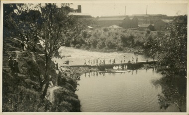
Photograph - Crossing Dights' Falls on the Yarra by foot
... Crossing Dights' Falls on the Yarra by foot.... Dight's falls River Yarra -- Kew - Abbotsford Reverse: "M Holmes ...Dight’s Falls in Studley Park is an artificial weir built on a natural rock bar across the Yarra. The weir was built in the 1840s to provide water to the ‘Ceres’ flour-mill, one of the first in Victoria. The falls were later to become known as Dight’s Falls after the owners of the mill. Later, a pumping station was built on the Kew side of the river, which pumped water uphill to a reservoir in Walmer Street that provided water to the Melbourne Botanical Gardens and to Albert Park Lake. The area around Dight’s Falls was and is frequently used for recreational activities.Rare original print photograph of people walking across Dight's Falls when the river flow was low. View west towards Abbotsford. Photograph taken from Kew side of river above the Falls.Reverse: "M Holmes"dight's falls, river yarra -- kew - abbotsford -
Kew Historical Society Inc
Album - Victorian Canoe Club : Album 2, 1920-30
Canoeing on the River Yarra at Melbourne was an important and widespread recreational pursuit for Melbournians, especially in the first half of the twentieth century. The Victorian Canoe Club was formed in 1912 at a meeting in Melbourne and its first committee elected in the same year. Records indicate that the Club continued into at least the 1950s .The album has historic and social significance as a record of recreational activities (as well as canoe making) in the early years of the twentieth century. It has local significance as the site of the headquarters of the Club was in Studley park. A number of photographs in the album provide vistas of Kew on the Yarra that are otherwise unavailable.24 labelled photos in part album, originating from the Victorian Canoe Club, which had its headquarters in Studley Park, Kew. The album includes a photographic record of canoe construction and also locations in Studley Park and Kew where the canoes were used. Descriptive titles in the album include (sometimes referring to two photos): Steaming gear / Mould for racer / Ribs bent on mould / Planking [3] / Planking racer / Planking Nagha / Planking completed / Off mould / Built-up ends and deck frames / Racer completed (Retriever) / Nagha & Dnapna completed / V.C.C. Studley Park / On the Yarra / Through the rapids / Yarra near Bourke [sic] Rd [2] / Camp site near Bourke [sic] Rd / Dyghts [sic] Falls, Studley Park [2] / V.C.C. site, Studley Park / Y.M.C.A. Camp, Mornington.Each photograph is labelled in white inkvictorian canoe club, canoe making, river yarra, burke road, mornington, studley park, kew -
 Kew Historical Society Inc
Photograph - Dight's Falls, 1924
... , Henry Christian, is of Dight's Falls on the Yarra River from... Christian, is of Dight's Falls on the Yarra River from the Kew side ...Henry Beater Christian (1886-1962) , was a descendant of one of the earliest settler families in Kew. Employed at the Kew Asylum as a 'public servant', he was a skilled amateur photographer, photographing numerous scenes in Kew and on his travels around Victoria. The majority of his photographs date from 1916 to 1929. His finest photographs are housed in two photograph albums. Digital copy of a photograph from page 9 of the 47-page photograph album containing 261 gelatinous silver images, loaned by Diane Washfold with permission given to digitise and hold a copy in our collection. The point-of-view selected by the photographer, Henry Christian, is of Dight's Falls on the Yarra River from the Kew side. Dight's Falls separates the saline and fresh water sections of the river. "Studley Park / Kew"henry beater christian (1886-1962), landscape photography, kew (vic.) — yarra river, christian-washfold collection, photograph albums, yarra river -- studley park (vic.), dight's falls -
 Kew Historical Society Inc
Photograph - Steavensons Falls, c.1926
Henry Beater Christian (1886-1962) , was a descendant of one of the earliest settler families in Kew. Employed at the Kew Asylum as a 'public servant', he was a skilled amateur photographer, photographing numerous scenes in Kew and on his travels around Victoria. The majority of his photographs date from 1916 to 1929. His finest photographs are housed in two photograph albums. Digital copy of a photograph from page 19 of the 47-page photograph album containing 261 gelatinous silver images, loaned by Diane Washfold with permission given to digitise and hold a copy in our collection. This photograph, dating from c.1926, forms part of a group of photos taken on a bushwalking trip to Marysville, Victoria. John Chapman has written in 'Bushwalking Clubs - A Brief History', about the establishment in Victoria of the first bushwalking club in 1888, and the popularisation of bushwalking during the interwar period. The falls in the photograph is probably Steavensons Falls near Marysville."Marysville" [date illegible]henry beater christian (1886-1962), landscape photography, kew (vic.) — yarra river, christian-washfold collection, photograph albums, bushwalking -- victoria, marysville (vic.), steavenson falls -
 Kew Historical Society Inc
Print, Sands & Kenny, Dights Mill, 1856
... wood engraving, showing Dights Mill and Falls on the River... and Falls on the River Yarra. The image was originally published ..."In 1839 John Dight purchased Melbourne block 88, which included 26 acres of land along the Yarra River for £481 at the Port Phillip land sales held in Sydney. Dight was already in the business of flour milling and had a mill near Campbell Town in New South Wales called ‘Ceres’. In April 1840, he notified his customers through The Sydney Herald that he was leaving to go to Port Phillip. The first steam powered flour mill was constructed in Melbourne in 1841. Dight built his water powered mill, soon after, from bricks bought over from Tasmania. Dight used the river to power his mill: Water flowed along an inlet channel to turn an undershot water wheel. In order to regulate flow or to ensure flow for times when river levels were low, Dight constructed a rough stone weir." (Melbourne Water)Dights Mill. Reproduction of a book plate from an original wood engraving, showing Dights Mill and Falls on the River Yarra. The image was originally published in Sands & Kenny, Melbourne & Sydney.Annotation on reverse: "Dights Flour".dights mill, yarra river -
 Kew Historical Society Inc
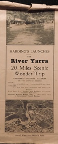
Flyer, Melbourne Ferries Pty Ltd, River Yarra: 20 Miles Scenic Wonder Trip
... Falls'. Flyer for Harding’s Launches on the River Yarra: 20 ...Bifold brochure including route map of the full 44 mile 'Wonder Trip' on pages 2 & 3. Photos used include an 'Aerial view over Dight's Falls', two ferries, and a 'Scene near Dight's Falls'.Flyer for Harding’s Launches on the River Yarra: 20 miles scenic wonder trip. Aerial view over Dight’s Falls on front. non-fictionBifold brochure including route map of the full 44 mile 'Wonder Trip' on pages 2 & 3. Photos used include an 'Aerial view over Dight's Falls', two ferries, and a 'Scene near Dight's Falls'.river yarra, melbourne ferries pty ltd, yarra river -- tourism, harding's cruises, christian-washfold collection -
 Kew Historical Society Inc
Photograph - The Boulevard at Kew, 1937
The Yarra Scenic Boulevard stretching from Hawthorn to the Chandler Highway was completed as a major project between 1933 and 1936 during a period of significant unemployment. Key dates in the construction this section the road include: 1933 when Kew Council supported the construction of the road from Studley Park to the Kew Asylum; and 1936 when the road from the Johnston Street Bridge to the Chandler Highway was opened. The inscription on the reverse of the photo 'Boulevard Fairfield' is misleading as there is no section of the Boulevard in Fairfield. A more likely interpretation is that it is a photograph of the Kew section of the Yarra Boulevard with the factories of Fairfield in the distance.Rare early photograph of the Yarra Boulevard, taken one year after the opening of the road. The photograph is an important historical record of the results of 'Susso' labor in the creation of major works in Melbourne by the Victorian Government. Original, black and white positive print of the Boulevard at Kew in 1937. Key aspects to note about the photograph is that the road is bituminised; that the gutters are concreted; that the kerb is constructed of concrete blocks; and that there is an unmade footpath on what appears to be the right hand side of the road. The landscape is sparsely treed, and those trees that remain are presumably remnant vegetation. At the right, the land is fenced. The land at the left falls away sharply to the river below. On the horizon, at left, there is an industrial complex including a tall chimney that is burning fuel creating smoke. "Boulevard Fairfield" great depression, susso projects, roads -- kew (vic.), yarra boulevard, yarra valley -
 Kew Historical Society Inc
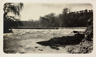
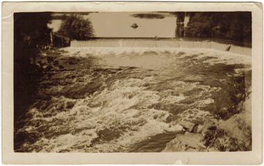
Photograph - The Race at Dight's Falls, 1925
... Inscribed verso: "The Race at Dight's Falls / River Yarra.... dight's falls river yarra yarra -- kew (vic.) Inscribed verso ...Dight’s Falls in Studley Park is an artificial weir built on a natural rock bar across the Yarra. The weir was built in the 1840s to provide water to the ‘Ceres’ flour-mill, one of the first in Victoria. The falls were later to become known as Dight’s Falls after the owners of the mill. Later, a pumping station was built on the Kew side of the river, which pumped water uphill to a reservoir in Walmer Street that provided water to the Melbourne Botanical Gardens and to Albert Park Lake. The area around Dight’s Falls was and is frequently used for recreational activities.Original, black and white positive of water flowing over the 'Race' at Dight's Falls in MelbourneInscribed verso: "The Race at Dight's Falls / River Yarra Melbourne / 1.3.25" "Kodak Print"dight's falls, river yarra, yarra -- kew (vic.)