Showing 110315 items matching "roads"
-
 Melbourne Tram Museum
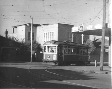
Photograph - Footscray - Buckley St tram 460, Jim Seletto, c1960
The photograph shows MMTB X1 class No. 460 in Buckley Street turning into Nicholson St on its way to Russell St from Williamstown Road. There is a Four Square grocery shop on the corner.Yields information about trams in Buckley St Footscray c1960.Black and White photograph with photographer's notes on rear"J Seletto photo"trams, footscray, x1 class, tram 460, buckley st -
 Canterbury History Group
Photograph - Jack Morris Wood Merchant, Leader Associated Newspapers, 17/07/1986
Photograph of Jack Morris (known as Canterbury Jack), wood merchant of Maling Road Canterbury, behind Bradshaws garage. From the Progress Press of 16 July 1986 on his death at 93.Black and white photographcanterbury, maling road, d.h.bradshaw auto service pty ltd, canterbury jack, fuel merchants, morris> jack -
 Melbourne Tram Museum
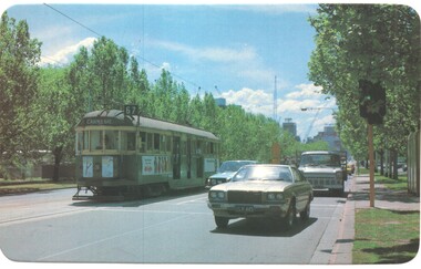
Postcard - St Kilda Road - W2 592, Arght Industries, late 1970s
Arght Industries postcard of W2 class number 592 (Carnegie, Route 67) outbound in St Kilda Road Melbourne. Postcard very similar to those of Carinya postcards - possibly related.Yields information about St Kilda Road and W2 class trams.Postcard - by Arght Industries with rounded corners, address block, Number LV019 trams, tramways, w2 class, tram 592, st kilda road, carnegie -
 Melbourne Tram Museum
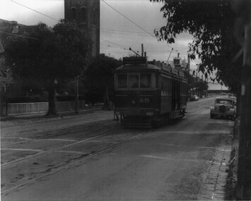
Photograph - VR tram 49 Bay Road Sandringham, 18-9-1956
Photo shows VR tram 49 in Bay Road, shortly after leaving Sandringham Station for Black Rock on 18-9-1956. The tram line closed on 5-11-1956Yields information the Sandringham to Black Rock tramway.Photograph - Black and White, printed on an A4 sheet.At one end of the print " #247 Bay Rd. No. 49 on down Sat. 18-9-1956"trams, tramways, tram 49, bay road, sandringham, black rock, vr trams -
 Whitehorse Historical Society Inc.
Document, Insulwool Factory, 2025
Information regarding the Insulwool Factory in Blackburn until its closure in 1995.non-fictionInformation regarding the Insulwool Factory in Blackburn until its closure in 1995.insulwool factory, bunnings warehouse nunawading, whitehorse road nunawading no 250, csr bradford, bannister giselda -
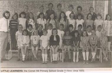 Bendigo Historical Society Inc.
Newspaper - JENNY FOLEY COLLECTION: LITTLE LEARNERS
Comet Hill school operated from 1965 to 2010. In 2011 it amalgamated with North Bendigo Primary which then closed. The combined schools became the Lightening Reef Primary School in Holmes Road.Bendigo Advertiser ''the way we were'' from 2003. little learners: the Comet Hill primary school grade 3 class, 1972. the clip is in a folder.newspaper, bendigo advertiser, the way we were -
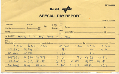 Melbourne Tram Museum
Document - Report, Hugh Waldron, "Trams in Hawthorn Depot 1991 & 1996", 1991 & 1996
Lists "Trams in Hawthorn Depot 14-2-1996" - by tram number and depot road - 21 trams. 2nd list dated 25/1/1991 - 28 trams and 4 buses.Yields information about trams stored at Hawthorn early 1996.Report written The Met Special day report form - yellow paper and plain yellow papertramcars, tramways, lists, hawthorn depot, stored trams, buses -
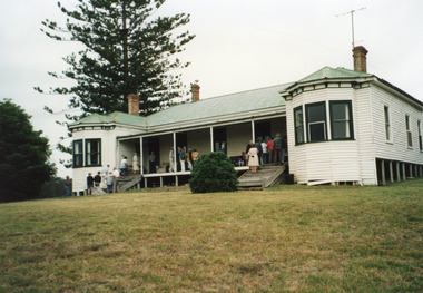 Lakes Entrance Historical Society
Photograph - Lake Tyers House, 1995
Lake Tyers House built 1886 by R Krokel of Bairnsdale as guest house and stop over being on the coastal road to Orbost and Merimbula. Guest house from 1886 to 1960's.Colour photograph taken at Lake Tyers House, a large timber dwelling built in Victorian Italianate style with two projecting faceted bay windows, corrugated iron roof. Three internal brick chimneys visible through roof. Situated on a prominent headland with a view of Lake Tyers. Lakes Tyers Victoriaaccommodation, guesthouses -
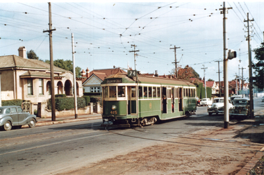 Melbourne Tram Museum
Photograph - Tram 415 - Riversdale Road, Travis Jeffrey, mid 1950s
Colour print showing W2 class tram No. 414 (Burwood Route 74), at the junction in Riversdale Road for Camberwell Depot. Note the signal light on the pole on the right hand side of the photograph.Yields information about tram 415 and the junction with the Camberwell Depot tracks.Colour print on Fujichrome paper.trams, tramways, tram 415, riversdale road, cambewell depot -
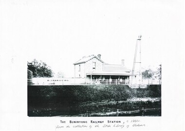 Buninyong & District Historical Society
Print - Black and white copy of Yendon (Buninyong) Station c1860s, The Buninyong Railway Station
Yendon Railway Station, built 1862 as Buninyong (East) Station. Yendon No.1 and No. 2 Roads constructed to connect cab service with the township of Buninyong. The station name was changed to Yendon 1878.This image illustrates The Buninyong Railway Station in the 1860's on the Ballarat to Geelong line, its name was changed to Yendon Railway Station in 1878 and was demolished in 1969A black and white copy of a photograph of Buninyong (Yendon) Railway Station in the 1860sThe Buninyong Railway Station, c 1860s from the collection of the State Library of Victoriabuninyong railway station, yendon (buninyong east) railway station -
 Melbourne Tram Museum
Photograph - PMTT tram No. 4
The photograph of PMTT tram No. 4 in a shopping strip with centre poles - possibly Glenferrie Road. Has "Municipal Tramways" on the side which indicates it was a PMTT tram, not HTT. Passengers are boarding the tram.Yields information the PMTT tramcar No. 4.Black and white photograph with notes on the rear.In pencil "Neg 14 057, Hawthorn Tys"tramcars, tramways, pmtt, tram 4 -
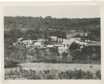 Lakes Entrance Historical Society
Postcard - Oil shaft complex, H D Bulmer, 1945c
Lakes Entrance Oil Shaft complex which was in production c 1943 to 1952 situated in low terrain north of the town between Myers Street and Palmers Road Lakes Entrance VictoriaBlack and white postcard of Lakes Entrance Oil Shaft complex Lakes Entrance Victoriaoil, exploration -
 Kiewa Valley Historical Society
Set of 2 hand coloured photographs of early Mount Beauty, photographs of Mount Beauty, 1947/48
Construction of the town of Mount Beauty commenced in 1946 and continued until 1952. It was built to provide family accommodation for workers engaged in the construction of the hydro electric power scheme. As well as housing, there was an administration building, staff hostel, merchandising centre, workmen's camps, base stores and workshops and the Mount Beauty Terminal Station. The first house was occupied in November, 1946 by the then manager of the trading store, with a frontage onto Hollonds Street. The total number of houses erected was 488, 162 custom built and 326 prefabricated. The main workmen's camp can be seen just left of the centre of the photograph and accommodated 144 men at the time of the photograph. By 1950 it could accommodate 1200men. Photo No. 1 is taken in 1947/early 1948 as there is no evidence of the staff hostel under construction. This hostel was commenced in August/September 1948 and is clearly shown in photograph No. 2, dating this photo as 1948 as it is before the completion of the bypass road connecting to the main (high plains) road. This road was constructed in 1939 and in 1948 followed the route of Tawonga Crescent. This remained in use until the bypass construction was completed in early 1949 and does not appear to be finished in this photograph.. Both photographs are taken from the power line easement adjacent to the Bright road.Significant historical pictorial record of the development of a town from grazing land. The type of terrain that had to be surveyed and then to construct roads and other infrastructure, with very little machinery, is also of prime significance in the development of the Kiewa Hydro Electric Scheme.Two photographs, both hand painted to show colours, and both of Mount Beauty c 1947/48 not long after commencement of construction of homes and facilities for workers.Photo No.1 - on back of photo, left upper corner, faintly in pencil, SPIKE, underneath this is written T Pay,. Photo No. 2 - on back of photo, left upper corner, faintly in pencil, Jmount beauty, housing, accommodation -
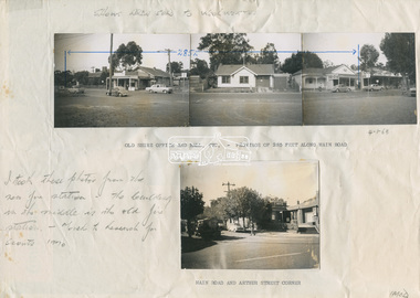 Eltham District Historical Society Inc
Document - Photograph, Ian McDonald (Shire of Eltham), Main Road, between Arthur Street and Dudley Street, Eltham, 1968-1970
Original document produced by Ian McDonald (Eltham Shire Council) 1970. During the period 1969-1971 photos were being collected for a proposed publication on the history of the Shire of Eltham as part of its centenary celebrations in 1971 (managed by the Shire of Eltham Historical Society and Alan Marshall). The publication was Pioneers & Painters (1971), edited by Alan Marshall. The document titled "Shows area sold to Woolworths" consisted of a panorama of three B&W photo prints creating a panorama of the frontage along Main Road (SEPP_0744) and a single B&W photo print of the Shire of Eltham offices and Hall on the corner of Arthur Street and Main Road (SEPP_0737) along with typed and hand written notes by Ian McDonald. The panorama (SEPP_0744) was captioned in typewritten text "Old Shire Office and Hall, etc - Frontage of 285 feet along Main Road" and in pencil the date "4-1-68" The single image of the shire offices (SEPP_0737) was captioned in typewritten text "Main Road and Arthur Street Corner" In addition, the following handwritten notes in pencil: " I took these photos from the new fire station - the building in the middle is the old fire station - Moved to Research for the Scouts 1970" and signed "IMcD"This photo forms part of a collection of photographs gathered by the Shire of Eltham for their centenary project book,"Pioneers and Painters: 100 years of the Shire of Eltham" by Alan Marshall (1971). The collection of over 500 images is held in partnership between Eltham District Historical Society and Yarra Plenty Regional Library (Eltham Library) and is now formally known as the 'The Shire of Eltham Pioneers Photograph Collection.' It is significant in being the first community sourced collection representing the places and people of the Shire's first one hundred years.Paper with four photos adhered in two groups with notes in typewritten text and handwritten in pencilsepp, shire of eltham pioneers photograph collection, eltham, main road, arthur street, dudley street, barber shop, cinema, commercial bank of australia, eltham fire brigade, eltham hall, eltham shire hall, eltham shire office, fire station, hardware shop, municipal offices, photographer shop, pph, produce paint and hardware centre, shire hall, shire offices, woolworths -
 Eltham District Historical Society Inc
Negative - Photograph, Bridge on Main Road, Eltham, c.1890
Possibly produced as a postcard. Caption in lower right hand corner reads: Bridge (at) Main Road Eltham. The long wooden suspension bridge over the Diamond Creek on Main Road at Eltham collapsed during flooding of the Diamond Creek on October 13 and 14, 1923. The original bridge was built around 1840 for the coach road when Cobb & Co.'s coach was the only conveyance between Eltham and Melbourne. Widespread damage was done in Melbourne and surrounding areas by floods resulting from the overflow of the Yarra at many points along its banks. A temporary bridge rigged up was severely damaged by the flooding of the creek and was closed to vehicular traffic in April 1924. A new concrete bridge was constructed to replace it and by May 1926 all the concrete piles and abutments had been completed. The bridge was finally completed and opened for traffic in September 1926, almost three years after it initially collapsed. Viewed from Antoinette Boulevard looking northwest towards Falkiner Street. The building in the distance believed to be Souters Cottage. On the far right on the very edge of the road verge are two Eucalypt trees, one of which is believed to be the large dead trunk still standing in present day.This photo forms part of a collection of photographs gathered by the Shire of Eltham for their centenary project book,"Pioneers and Painters: 100 years of the Shire of Eltham" by Alan Marshall (1971). The collection of over 500 images is held in partnership between Eltham District Historical Society and Yarra Plenty Regional Library (Eltham Library) and is now formally known as the 'The Shire of Eltham Pioneers Photograph Collection.' It is significant in being the first community sourced collection representing the places and people of the Shire's first one hundred years.Digital image 4 x 5 inch B&W Neg Black and white print 35mm positive transparencyshire of eltham pioneers photograph collection, eltham, main road bridge, eltham south, bridge, diamond creek (creek), significant tree, souters cottage, eltham lower park, main road, sepp -
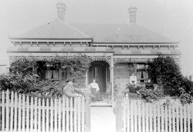 Surrey Hills Historical Society Collection
Photograph, "Braemar" 18 Suffolk Road, Surrey Hills
"Braemar" at 18 Suffolk Road, Surrey Hills - built c1894, demolished in1977 – and home of James Sneddon Snr. and family from 1890 until c1950. We believe it is James is at the gate and his family on the veranda. James was born in Alloa, Clackmannanshire Scotland in 1833, as was his wife Jane. He died in March 1901 and she in March 1911. They are buried in Boroondara Cemetery (Pres B0522) with their daughter Jane (1864-1928). James Sneddon (Snr) was an important man in early Surrey Hills. He established real estate and ironmongery businesses in Union Road – first on the corner of Stirling Crescent and later over the road on the corner of Windsor Crescent. He was chairman of Surrey Hills’ MUIOOF (Manchester Unity Independent Order of Oddfellows). James Sneddon Jnr. followed his father in the family real estate business and was an even busier community man. He was a JP and had roles in the Surrey Hills ANA, the Progress Association and the Choral Society. He lived 2 doors from his father. The real estate business continued on the corner of Windsor Crescent and Union Road (north side) until the business was sold to the Doubleday (family) after WW2.The Sneddon family were early settlers and business owners in Surrey Hills and remained over 3 generations. Different family members held many roles in community organisations. This photo is also important in documenting built heritage that has been demolished.Image of a Victorian, weatherboard, block fronted, single storey house with decorative veranda, viewed from the front. The garden in front of the house is well established and a light-coloured picket fence surrounds the property. Four people are in the photograph, three women (two seated and one standing) on the veranda and one male, who is leaning against the gate post.buildings, structures and establishments, houses, timber houses, house names, braemar, architectural styles, victorian style, families, family group, sneddon family, james sneddon (snr), boroondara cemetery, real estate agent, ironmonger -
![Map, Millbank Estate Bacchus Marsh Thursday 4th October 1888 [Land sales], 1924](/media/collectors/5e461d8021ea67224c82f2a1/items/67765662eb6d2cbd24e0797f/item-media/67765682eb6d2cbd24e07a41/item-fit-380x285.jpg) Bacchus Marsh & District Historical Society
Bacchus Marsh & District Historical SocietyMap, Millbank Estate Bacchus Marsh Thursday 4th October 1888 [Land sales], 1924
The Millbank Estate was a parcel of land close to the centre of the shopping area of Bacchus Marsh which was sub-divided and offered for sale in 62? lots on the 4th October 1888. The lots had frontages to Ballarat Road (Main Street), Maddingley Road (now Grant Street), Turner Street, Millbank Street, Clarinda Road (now Clarinda Street), and an unnamed street south of Turner Street (possibly known as Grant Street at this time) which connected to Maddingley Road through the vicinity of the present day Bacchus Marsh Hospital. This was a significant sub-division of land and represented a major expansion of residential housing in Bacchus Marsh in the late 19th century. The map includes a wealth of detail about the time of the sale, where it will take place, who the selling agents were, the deposit terms for purchases and details of a special train from Melbourne to Bacchus Marsh on sale day. The location of the allotments in relation to the shopping and commercial area of Bacchus Marsh, Maddingley and the railway station are indicated on an inset map within the overall map and poster. The Millbank Estate area was an area which had once belonged to the Grant family who were prominent early citizens of Bacchus Marsh and lived in a house in this area known as 'Millbank'.This land sale map is a typical example of housing estate land sales advertising maps produced by real estate agents in this era. The map is significant for the detailed information it provides about when and where land was sold for new housing estates in Bacchus Marsh in the late nineteenth century.Single page map showing land allotments for sale at auction in Bacchus Marsh in October 1888. A significant portion of the map is missing from the bottom right side. land sales bacchus marsh, land subdivsion bacchus marsh, housing estates land sales bacchus marsh, grant family bacchus marsh, millbank estate land sales -
Whitehorse Historical Society Inc.
Document, The 'Mullens House', n.d
Story of the 'Mullens House', originally small dwelling made of hand made bricks by Mrs Mullens' father, Mr Forbes of Glen Waverley. Came from Scotland 93 years ago. As the family increased more rooms were added. Hugh Mullens was a woodcutter and later an orchardist and later still a road contractor. Mrs Tainton, a daughter, still lives in part of the original property. Another daughter, Mrs Stocks who was a widow stayed on with her mother at the old home. It is now the property of Melbourne & Metropolitan Board of Works. Mr & Mrs Hugh Mullen's had 12 children. Mr Mullen's parents lived in Highbury Road, near East Burwood Primary School and were pioneers of East Burwood.hugh, forbes, tainton, r (mrs), stocks, (mrs), melbourne and metropolitan board of works, highbury road, mullen's -
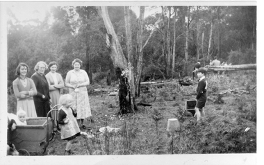 Southern Sherbrooke Historical Society Inc.
Photograph - Menzies Creek hall preparatory work, c. 1953
Photos 051/267 and 051/268 are 2 copies (one named) of a black and white photograph showing a Working Bee at the Menzies Creek Hall site. Photos 051/269 is a close up of the left side of the photo, showing Carol King, Grace Martin, Barbara Haig and Mrs Haig, along with Lyn Hermon (baby) and Jay Hermon (toddler). Photo 051/270 is a close-up of Rodney Haig, with Mr Martin in the background wearing a hat. Other men can be seen in the background. The photo shows the land being cleared in preparation for the building of the Mnezies Creek Hall in 1953. Tall trees are in the middle and background. The hall is situated on the south-east corner of Belgrave-Gembrook Road and School Road. -
 Kew Historical Society Inc
Plan - Subdivision Plan, Old Kew Golf Links Estate - Third Section, 1920-1929
Pru Sanderson, in her groundbreaking ‘City of Kew Urban Conservation Study : Volume 2 - Development History’ (1988), summarised the periods of urban development and subdivisions of land in Kew. The periods that she identified included 1845-1880, 1880-1893, 1893-1921, 1921-1933, 1933-1943, and Post-War Development. These periods were selected as they represented periods of rapid growth or decline in urban development. An obvious starting point for Sanderson’s groupings involved population growth and the associated economic cycles. These cycles also highlighted urban expansion onto land that was predominantly rural, although in other cases it represented the decline and breakup of large estates. A number of the plans in the Kew Historical Society’s collection can also be found in other collections, such as those of the State Library of Victoria and the Boroondara Library Service. A number are however unique to the collection.The Kew Historical Society collection includes almost 100 subdivision plans pertaining to suburbs of the City of Melbourne. Most of these are of Kew, Kew East or Studley Park, although a smaller number are plans of Camberwell, Deepdene, Balwyn and Hawthorn. It is believed that the majority of the plans were gifted to the Society by persons connected with the real estate firm - J. R. Mathers and McMillan, 136 Cotham Road, Kew. The Plans in the collection are rarely in pristine form, being working plans on which the agent would write notes and record lots sold and the prices of these. The subdivision plans are historically significant examples of the growth of urban Melbourne from the beginning of the 20th Century up until the 1980s. A number of the plans are double-sided and often include a photograph on the reverse. A number of the latter are by noted photographers such as J.E. Barnes.When the old Kew Golf Links was subdivided in the mid 1920s, the developers were able to break the sale into sections. The third section included eighty lots. The lots faced Kilby Road, Kodak Avenue, Belford Road, Baker Avenue, Mathers Avenue, and White Avenue. [Kodak Avenue was renamed Page Avenue at a later date].The ‘Kew Conservation Study (1988) notes that ‘On the subdivision plan, Kodak’s involvement is commemorated by the naming of the streets after Company directors, and their decision to not proceed with the construction of the factory is explained as a response to the increase in the value of the land. This explanation may have been Estate Agent’s hyperbole, as the Kodak Company records suggest that the land, with its wide creek gully, was unsuitable and too small for its purposes.subdivision plans - kew, old kew golf links estate - third section -
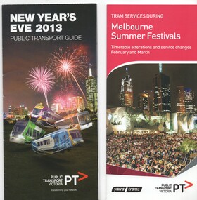 Melbourne Tram Museum
Pamphlet, Yarra Trams, "New Year's Eve 2013", 2013 and 2016
Pamphlets - set of 2 printed in full colour on paper folded to DL size. .1 - "New Year's Eve 2013" - 8 fold, 2 half foldout - with a map showing fire works sites, locations, tram alterations, and how public transport could be used in the city. .2 - "Tram service during Melbourne Summer Festivals" - 4 fold, - issued 1/2016, detailing timetable alternations and service changes for Feb. and March - includes events - St Kilda Festival, White Night, Glenferrie Road Festival, Sydney Road festival and Moomba Parade. Has a calendar and maps. Also lists other major events and network upgrade and tram improvement works. Issued by Yarra Trams and the PTV.trams, tramways, events, melbourne, moomba, glenferrie rd, sydney rd, st kilda -
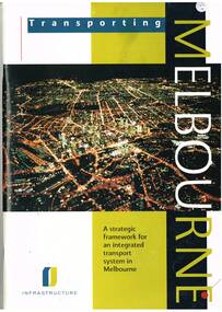 Melbourne Tram Museum
Book, Department of Infrastructure (DOI), "Transporting Melbourne - a Strategic framework for an integrated transport system in Melbourne", Sep.1996
Book - 92 pages, centre stapled, printed on gloss paper titled "Transporting Melbourne - a Strategic framework for an integrated transport system in Melbourne", issued September 1996. Has a message from Minister Alan Brown - Minister for Transport and Geoff Craige Minister for Roads and Ports. Looks at the strategic context, the system, integration and land use, public transport needs and reforms, road networks, industry, management, environmental sustainability and structural reform. Includes chapters on trams and buses. Has many figures and maps. 613.1 - Book - 28 pages centre stapled, printed on gloss paper titled "Transporting Melbourne - A summary for public consolation" issued Sept. 1996, summary of above document. Full pdf image of the book added.trams, tramways, melbourne, public transport, transport -
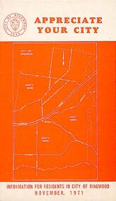 Ringwood and District Historical Society
Pamphlet, Appreciate Your City - Information for Residents in the City of Ringwood - November 1971, 1971
Orange coloured community information brochure for Ringwood residents covering Councillors' contact details and local services, sporting, and cultural facilities. Includes two City of Ringwood Free Tipping Vouchers valid until the end of 1972, Council permit requirements, Nature strips and street trees, Vandalism, Road safety and Parking regulations.rinx -
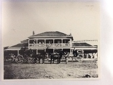 Port of Echuca
Photograph, Approx. 1970's
The Bridge Hotel was built by Henry Hopwood to house visitors to the town crossing the Murray River on his punt , which was situated just below the Bridge Hotel on the Murray River. The accommodation was spacious and grand! In the right back corner of the photograph, the 'lantern' roof of the St George's Hall can be seen. The street is level with the front entrance to the Hotel, which is very different to what it is today.The photograph shows hotel activities and accommodation in the late 19th Century. The Bridge Hotel was a very busy place as can be seen with women on the balcony, a stage coach full of people, laden carts and buggies.The Bridge Hotel Echuca - photo taken looking south towards front of building. Four people can be seen on the balcony and several gathered under the verandah. In the foreground are several horse-drawn carriages. The road in front of the hotel is unmade and very wide, with the roof of St.George's Hall seen over the right (western) wing of the hotel. Verso: Bridge Hotel, 1860s? St. George's Hall in background.bridge hotel, henry hopwood, lantern roof, st.george's hall, 1870s -
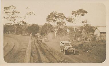 Phillip Island and District Historical Society Inc.
Photograph - Post Card, Cowes School Back to 1926 Chapel Street, March 1926
Donated by Stan McFee from the Keith McIlwraith CollectionSepia postcard of four cars , decorated with streamers, driving along Chapel Street going west on unmade road. Land on left was owned by Methodist Church, corner of Chapel and Bass Ave., where large tree denotes the boundary. Finley? Forrest's house on right. Coming to Back to Cowes School Celebration March 1926On back: "Back to Cowes March 1926"celebrations - back to cowes school phillip island, decorated cars, phillip island, stan mcfee, keith mcilwraith collection -
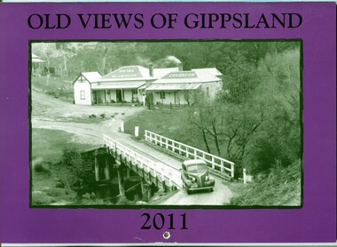 Orbost & District Historical Society
calendar, Old Views of Gippsland 2011, 2010
This is one of a series of calendars published annually by East Gippsland Historical Society.This item is a useful reference tool.A 2011 stapled calendar, titled "Old Views of Gippsland". On the purple coloured front is a black/white photograph of The Blue Duck Hotel at Angler's Rest on the road to Glenn Wills C/1940. It contains early photographs of East Gippsland, one for each month. There is a hole for hanging. The title is at the top and the year at the bottom in black print. calendar-old-views-of-gippsland photographs-historic-gippsland -
 Ringwood and District Historical Society
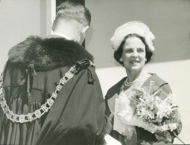
Photograph, Official opening of Heathmont Infant Welfare Centre, 30th November 1960. Lady Brooks
Official opening of Heathmont Infant Welfare Centre, 30th November, 1960. Lady Brooks.. All material is from Gwen Horman’s three albums that she owned. Some photos have been taken by Peter Payens of Ringwood Studios, 36 Whitehorse Road, Ringwood, WU-7609, probably for the Ringwood mail newspaper. -
 Ringwood and District Historical Society
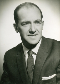
Photograph, Official photo of Cr Bob Horman at Ringwood Proclamation, March 1960
Official photo of Cr Robert "Bob" C Horman at Ringwood Proclamation, March 1960. All material is from Gwen Horman’s three albums that she owned. Some photos have been taken by Peter Payens of Ringwood Studios, 36 Whitehorse Road, Ringwood, WU-7609, probably for the Ringwood mail newspaper. -
 Bendigo Historical Society Inc.
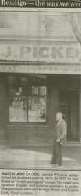
Newspaper - JENNY FOLET COLLECTION: WATCH AND CLOCK
Bendigo Advertiser ''The way we were'' from 2000. Watch and clock: James Pickens established his business prior to 1872. In 1901 he was listed as ''watch and clock'' maker. He made and repaired English and colonial jewellery to order. The premises were on the High Street and Sailors Gully Road junction. The clip is in a folder.newspaper, bendigo advertiser, the way we were -
 Bendigo Historical Society Inc.
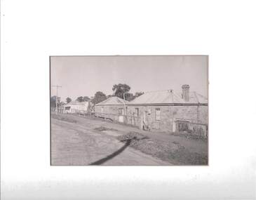
Photograph - HARVEY TOWN, EAGLEHAWK, 1960's ?
Black and white photograph: streetscape of Harvey Town, Eaglehawk. Dirt road, with dirt footpath. Two stone cottages on RH side of photo, white painted stone ( ? ) cottage with a verandah on LH side of photo. Cottages have iron roof, brick chimneys. A wire fence runs across the front of the cottages. A. Doney photo ?place, streetscape, harvey town