Showing 2288 items matching " parish."
-
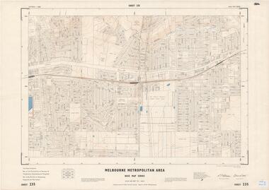 Ringwood and District Historical Society
Map - Melbourne Metropolitan Area Base Map Series, Sheet 235 - Ringwood area, 1960
Map prepared by Dept of Lands and Survey and MMBW from State Aerial Survey June 1957 and Cadastral Survey information August 1960. This sheet comprises parts of Municipalities of Doncaster & Templestowe, Nunawading and Ringwood, and Parishes of Nunawading, Ringwood and Warrandyte.Scale: 400 feet to 1 inch. Contours at 5 feet vertical interval. By Authority: A.C. Brooks, Commonwealth Printer, Melbourne. -
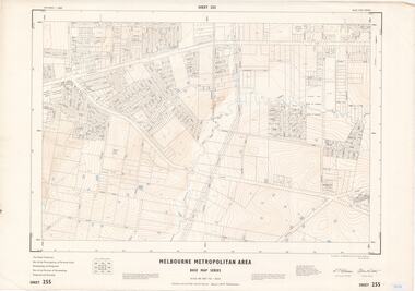 Ringwood and District Historical Society
Map - Melbourne Metropolitan Area Base Map Series, Sheet 255 - Ringwood area, 1963
Map prepared by Dept of Lands and Survey and MMBW from State Aerial Survey December 1956 and Cadastral Survey information May 1963. This sheet comprises parts of the Municipalities of Ferntree Gully, Nunawading and Ringwood, and Parishes of Nunawading, Ringwood and Scoresby.Scale: 400 feet to 1 inch. Contours at 5 feet vertical interval. By Authority: A.C. Brooks, Commonwealth Printer, Melbourne. -
 Bendigo Historical Society Inc.
Map - CAMPBELL COLLECTION: BENDIGO AND DISTRICT MAPS, 16-4-29
Map. Kennington, Parishes of Sandhurst, Mandurang and Strathfieldsaye. Scale 20 chains to 1 inch. Total area 2918 acres. Prepared in W.P.B. from A. and C.L. Plans by W.J.Galbraith, 16-4-29. (number 394 in map cupboard 1)W.J.Galbraithmap, bendigo, allotments -
Bendigo Historical Society Inc.
Map - CAMPBELL COLLECTION: BENDIGO AND DISTRICT MAPS, 6-4-28
Map. Sedgwick, Parishes of Strathfieldsaye, Lyell, and Sedgwick. Scale 20 chains to 1 inch. Total area 5372 acres. Prepared in W.P.B. from C.L.and A. Plans by W.J.Galbraith 6-4-28. (number 400 in map cupboard 1)W.J.Galbraith.map, bendigo, agricultural lands -
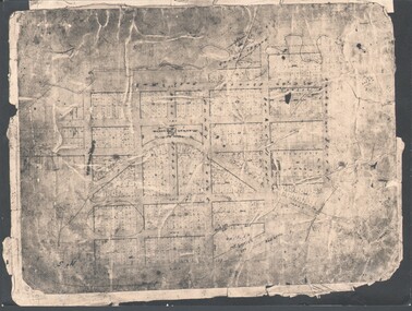 Bendigo Historical Society Inc.
Photograph - WES HARRY COLLECTION: TOWNSHIP OF SANDHURST, 1854
Photograph of the Parish Plan of the Township of Sandhurst in 1854. It covers the area of the CBD from Mitchell (not named) to Bernal Streets and from the Bendigo Creek to Mollison St. ( other than Pall Mall and McRae streets, none of these parallel streets are named)place, bendigo, first survey, sandhurst, first survey, bendigo creek -
 Bendigo Historical Society Inc.
Document - MCCOLL, RANKIN AND STANISTREET COLLECTION: GOLD MINING LEASE CROWN LAND, 1937
Document : McColl, Rankin and Stanistreet: gold mining lease crown land 10916 Bendigo. Foolscap size document, includes map County of Bendigo, Parish of Mandurang. Dated 1937 between King George VI and John Jepson Stanistreet.person, mining, john jepson stanistreet, mccoll, rankin and stanistreet: bendigo, mining, goldmining, john stanistreet -
 Bendigo Historical Society Inc.
Document - MCCOLL, RANKIN AND STANISTREET COLLECTION: DEBORAH EXTENDED GOLD MINING COMPANY NL, 1968
Document: McColl, Rankin and Stanistreet - Deborah Extended Gold Mining Company gold mining lease document. No. 11390, Vol. 334, Fol. 727, dated 21 Sept. 1967, - adjoins Fletcher Street, County of Bendigo, Parish of Sandhurst.organization, mining, deborah extended gold mining compan, mccoll, rankin and stanistreet, deborah extended gold mining company, gold mining, lease documents -
 Bacchus Marsh & District Historical Society
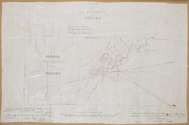
Map, Plan of the Village of Melton
A single page paper map showing a plan for the village of Melton, Parish of Djerriwarrh, County of Bourke. The map is pasted into a bound volume containing 76 maps or plans in total. High resolution digital image stored on BMDHS computer network. melton victoria maps -
 Lakes Entrance Historical Society
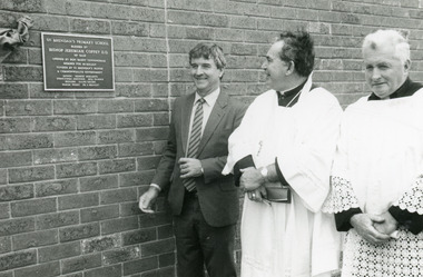
Photograph - St Brendans Lakes Entrance, Lakes Post Newspaper, 1994
Black and white photograph taken during the opening of St Brendans Primary School extensions, showing Barry Cunningham member from McMillan Bishop Jeremiah Coffey DD Parish Priest Father John Shanley Lakes Entrance Victoriaschools, celebration, officials -
 Bendigo Historical Society Inc.
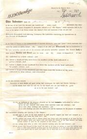
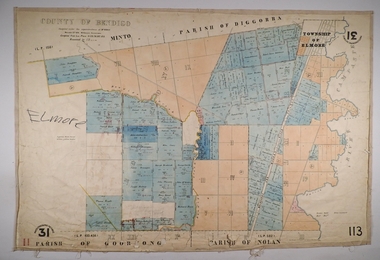
Map - ELMORE, 3/03/1875
Map: Elmore, County of Bendigo. Parish plan Paper canvas backed. Compiled under the superintendence of Mr. BIERS November 12th W. H. GREGSON DRAUGHTSMAN Compiled from local plans 31.215.216.502.833. Examined by E. D. 27.11.74map, bendigo, parish plan, elmore, w.h. gregson, mr. biers -
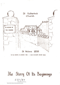 Eltham District Historical Society Inc
Folder, St Katherine's Church, 1999
Two brochures about the history of St Katherine's Anglican Church and its role in the Anglican Parish of Diamond Creek. One dated by hand 1983 and one dated by hand 2013.5 pages. Two brochures.HG Booklet 26harry gilham collection, st helena, st katherine's church -
 Greensborough Historical Society
Plan, Plan of Manatunga Circuit Greensborough subdivision, 1970_
Plan of Manatunga Circuit subdivision. Prepared by O'Connor and Beveridge (land surveyors) for Development Underwriting (developers). Plan of subdivision. Part of Crown Portion 3. Parish of Nillumbik, County of Evelyn.An original example of a subdivision plan in the expanding suburb of Greensborough. The 1960s and 1970s saw this area develop from a rural farming area to a suburb.Plan of subdivision. Printed on buff paper, hand coloured. Mounted on cardboard. Includes 2 small cards attached.Various handwritten comments. Small cards from Survey Branch, Office of Titles.greensborough, manatunga circuit, diamond creek road, plenty river drive -
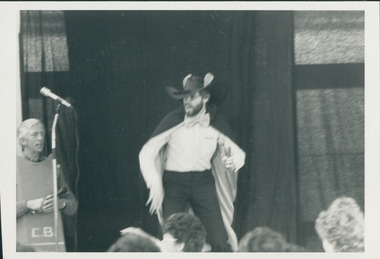 Uniting Church Archives - Synod of Victoria
Photograph, Risky Rat in musical at Wheelers Hill, 20/10/1985
"Worshippers at Wheelers Hill church, Mulgrave parish, saw the plot thicken on Sunday October 20 when locals presented the musical "Singsational Servants" from the Kids Praise series."Mann is shown dressed in costume as Risky Rat.Identification of Mann as Risky Rat.risky rat, singsational servants, kids praise -
 Ballarat and District Irish Association
Photograph - Colour, Clare Gervasoni, St Patrick's Cathedral, Ballarat, 2007, 20/11/2007
St Patrick's Cathedral first conducted services from 1851 onwards, the parish of Ballarat was instituted in 1852.The first Parish Priest was Father Matthew Downing,who selected in 1853 the two acres site for this church which was granted under a crown Grant in 1855. The style of the church is early Gothic from the era of Edward the 1st in the 13th Century. (http://www.ballarat.catholic.org.au/parishes/default.cfm?loadref=93, accessed 13 November 2013) Bishop James Alipius Goold OSA (Bishop of Melbourne) celebrated Mass in St Patrick's Ballarat on Sunday November 8th 1863. The Bishop had laid the foundation stone for the Church in 1858 and by November 1863 the Church was sufficiently completed to be used on a regular basis. (http://stpatscathedral.weebly.com/, accessed 13 November 2013) See http://www.ballarat.catholic.org.au/aboutus/default.cfm?loadref=9 A series of coloured digital photographs showing the bluestone church known as St Patrick's Cathedral, Ballarat.ballarat irish, st patrick, st patrick's cathedral, st patrick's cathedral ballarat, church, gothic, bluestone -
Glenelg Shire Council Cultural Collection
Souvenir - Plate, Westminster Australia, c. 1984
White fine china Westminster plate, commemorating St. Stephen's 150th Anniversary 1984. Depiction of St. Stephens Church centre of plate, in brown, inscription around edge of plate, in brown. Gold rim. History of St. Stephen's on back of plate and information that plate is one of a limited edition. Measures 26cm in diameter.Front: 'To commemorate 150 years of Worship St. Stephens Anglican Parish Portland 1834-1984'. Back: Limited Edition 500 Maker's mark Plate number 0345 Fine China Westminster Australia -
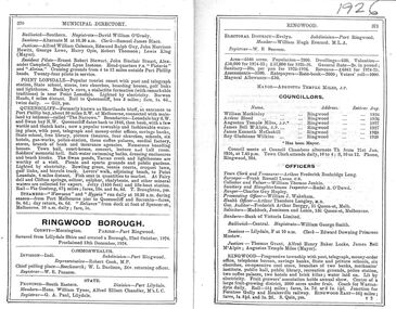 Ringwood and District Historical Society
Document, Extracts from the Municipal Directories for Ringwood Borough and Council from 1925 to 1992
Municipal Directories 1925 to 1992Contains information for Ringwood Borough and Ringwood Council - County - Parish - Electoral areas - Federal and State members - Area - Population - Rates, revenue - Councillors - Borough Officers - Description of the Borough, industries, halls, etc. -
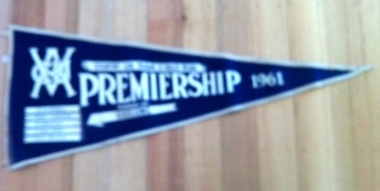 Geelong Cycling Club
Pennant Flag, 1961
The 1960s followed a period through the 1950s when Geelong gave the Empire Games and Olympic Games representatives. 1961 sees D Wilson - an Olympian - appear this decade. The 1970s will again supply Olympic and Commonwealth Games representatives to Australia.Geelong Cycling Club supplies representatives to Australia in the Olympic and Commonwealth Games .Triangular blue felt pennant flag bordered in white felt. It has the VACU insignia stamped in white and inscriptions of the details of the race and race winners stamped in white on it."VACU/Country Junior Teams 15 Miles Road/Premiership/1961/Runners-up/Geelong/B Murrell/L PArish/D Wilson/G Hanson/F Williams/Time:38:20.6"vacu; country junior teams; 15 miles road race; premiership; 1961; runners-up; geelong cycling club; b murrell; l parish; d wilson; g hanson; f williams; -
Bendigo Historical Society Inc.
Map - CAMPBELL COLLECTION: BENDIGO AND DISTRICT MAPS, 11-4-29
Map. Huntly, Parishes of Huntly Nerring and Neilborough. Scale 20 chains to 1 inch. Total area 4738 acres. Eaglehawk. Prepared in W.J.B. from A. and C.L. Plans by W.J.Galbraith 11-4-29. (number 396 in map cupboard 1)W.J.Galbraithmap, bendigo, agricultural lands -
Bendigo Historical Society Inc.
Map - CAMPBELL COLLECTION: BENDIGO AND DISTRICT MAPS
Map. Kimbolton, Parishes of Kimbolton and Lyell, scale 20 chains to 1 inch. Area by Planimeter 6258 acres. Knowsley. 10 1/2 miles to Strathfieldsaye. Campaspe River at bottom right of map. (number 365 in map cupboard 1)map, bendigo, allotments -
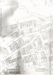 Bendigo Historical Society Inc.
Map - LONG GULLY HISTORY GROUP COLLECTION: SANDHURST AT BENDIGO
Copy of a map titled Sandhurst at Bendigo, Parish of Sandhurst, County of Bendigo. Some of the street names are: Quick, Rae, Casley, Bell. Thomas, Victoria, Roeder and Prout Streets. Allotments have the date, size, measurements and names on them. Some are unreadable.bendigo, history, long gully history group, the long gully history group - sandhurst at bendigo -
 Sunshine and District Historical Society Incorporated
Map (1967), CITY OF SUNSHINE, June 1967, 1967
The City of Sunshine no longer exists. Part of the eastern area has been annexed by the City of Maribyrnong, and the rest of the old City of Sunshine has been amalgamated with the City of Keilor to form the larger City of Brimbank.This 1967 map is a historical record of the City of Sunshine as it existed 27 years before the amalgamation of Councils, and the creation of the City of Brimbank in 1994.Whitish paper map with black printing that is laminated in clear plastic film, and has a wood slat attached to the top edge. The June 1967 map is of the previous CITY OF SUNSHINE showing City and Parish boundaries, streets, railways, creeks, river etc.Purple ink stamps at top left hand and right hand areas showing address and contact details of 'Sunshine Industrial Promotion Centre.'city of sunshine, june 1967, map, city, parish, boundaries, brimbank -
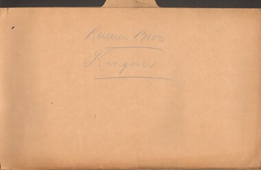 Bendigo Historical Society Inc.
Document - MCCOLL, RANKIN AND STANISTREET COLLECTION: REIMER BROS. KINGOWER
Manilla folder containing correspondence relating to Reimer Brothers claim at Kingower, also contains a large scale parish map of Kingower showing the position of the claim and leases 6278 held by Andrew Thomas Berriman and 6279 held by Florence Adelaide BerrimanMcColl Rankin & Stanistreetgold mining, miners' safety cage, kingower/union reef mines, gold mining, kingower, reimer brothers berriman -
Clunes Museum
Book, VARIOUS TITLES, 1960-1970
HYMN BOOK AND ORGAN MUSIC BOOKSOrgan Music Books .1 Living Parish Hymnal Accompaniment Book .2 Book Hymns & Music .3 The Australian Hymnal .4 Christian Brothers The Treacy Hymnal Accompaniment Book .5 Foolscap folder containing loose music sheetsHYMN BOOK AND ORGAN MUSIC BOOKShymns, sheet music, st. thomas aquinas -
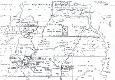 Greensborough Historical Society
Maps, Greensborough west of Plenty River, 1840o
Areas of Greensborough, west of the Plenty River, showing land holdings in the 1840s. Comprises Sections 8, 9, 10, 14, 15, 16, 17, 18, 19, 20 Parish of KeelbundoraOne A4 photocopy, one A3 enlargementgreensborough, watsonia, lower plenty, janefield -
 Charlton Golden Grains Museum Inc
Photograph, Brownjohn, Reg, Charlton Presbyterian Church and Hall mid-1980s, c.1890
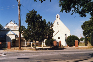
The Presbyterian Church was built in 1871 by local contractor and grazier James Patterson of Nardoo Park, Woosang. The Presbyterian and Methodist Churches formed combined Parish in 1969. The buildings were demolished in 1989.Colour photograph of Charlton Presbyterian Church and Hall. The white-painted brick church building is on the right. The letters A . D 1871 in black are on the front of the church. There is also a bell tower, a small gothic arched window and a small round leadlight window on the front wall. The church hall is a white weatherboard building with blue trim. Red brick pillars stand at the entrance to the church and the hall. A large electricity pole is in front of the hall. james patterson, charlton, presbyterian, church, pastoral care -
 Eltham District Historical Society Inc
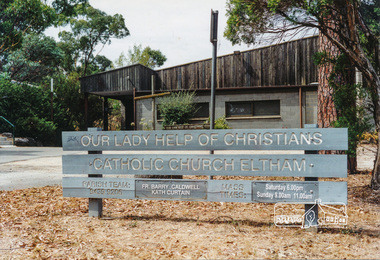
Photograph, Our Lady Help of Christians Catholic Church Eltham, January 2001
Wooden signage in the grounds at the front of the church. Our Lady Help of Christians Catholic Church Eltham Parish Team: [phone number] Fr. Barry Caldwell Kath Curtain Mass TimesColour photographeltham, our lady of help christians church, catholic church, sign -
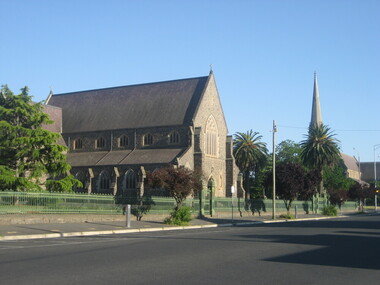
Ringwood and District Historical Society
Envelope, Packet 3 St Paul's Anglican Church, Ringwood, Circa 1920s-1990s
Various newsletters and local church records circa 1920s-1990s as follows: 4940-01 Parish Messenger – Easter 1927 4940-02 Parish Messenger – April, No.42 4940-03 Anglican News – November, No.15 4940-04 Parish Paper – April 1937 4940-05 Parish News Supplements – June 1969, August 1969, September 1969, April 1977 4940-06 List of Memorials in St. Paul’s Ringwood - 1971 4940-07 Civic Service, 30th Anniversary City of Ringwood – June 1990 4940-08 Opening and dedication of “Glamorgan Court” - 1989 4940-09 Civic Service Commemorating Proclamation of City of Ringwood – 20th March 1960 4940-10 Institution and Induction of The Reverend Douglas G. Edmonds - 12th December 1989 4940-11 Last Service at St Paul’s in Ringwood Street – 28th May 1967 4940-12 Catalogue, Art Exhibition – March/April 1979 4940-13 (duplicate entry deleted) 4940-14 Parish News “Spiritus Gladius” Centenary Celebration - 1979 4940-15 St.Paul’s Centenary Worship – 14th October 1979 4940-16 Service/Newsletter pamphlets - January to April 1996 (incomplete collection) 4940-17 Advertisement for New Theatre "Polling Day" concert at church hall (near Post Office) - 1961 4940-18 Commissioning of Penny Charters, Janice Dear, and David Jones as students in ministry 4940-19 Funeral Service for late Floss Davidson (Ms. V. Boulter) 19 January 1979 4940-20 Service of Thanksgiving for Rev. John & Mrs. Helen Howells - 18 June 1989 4940-21 Bush Church Aid 70th Anniversary, St Paul's Ringwood - 1 October 1989 4940-22 Parish Baptism, Confirmation and Eucharist - 12 November 1989 -
Bendigo Historical Society Inc.
Map - RAYWOOD GOLD FIELD MAP, 1902
Map. Raywood Gold Field Map. Linen backed map of Raywood and Neilborough Township and surrounds showing the location of varying underground workings. Surveyed by H S Whitelaw 1/6/02. It shows underground workings from The Perseverance Party and moreshed and Party and underground workings on the Old Pioneer Reef. Mentions the Parish of Yallook, Parish of Neilborough, Yarraberb, Mushroom Flat, Murray Valley Plain, Eaglehawk and Kerang Railway, Green Hill, Doughboy, Redmond's Gully, Pickpocket Lead, Raywood Lead, Inglewood Lead, Shaw's Road, Nuggety Shaft, Barkly Shaft, Maori Bendmap, gold field map, raywood gold field map, neilborough, h s whitelaw, geological survey of victoria bulletin no 12 plate 11 -
Ringwood and District Historical Society
Legal record - Conditions of Sale (C.E. Carter), Ringwood Electric Railway Estate, Lots 98 and 99, Sale to Tilbury and Albon, 1925
Original Particulars and Conditions of Sale document by C.E. Carter & F. H. Patterson & Co, to B.C. Tilbury Esq and A.J.Albon Esq: Lots 98 and 99, Electric Railway estate, Ringwood Plan of Subdivision 9473, Crown Portion 18, Parish of Ringwood. -
 Federation University Historical Collection
Letter, Grant Street Terraces, 1992
.1) 5 pages of correspondence relating to a request for survey of Crown Allotment 11, Section 11, Parish of Cardigan (included plan) .2) 3 pages relating to a tender for Bluestone / drystone terraces along the Grant Street frontage of the Ballarat School of Minesballarat school of mines, grant street, gillies street, j. winter, e.a. wynne, w.b. ochiltree, ballarat industrial school, prince of wales park, ballarat golf club