Showing 10395 items
matching plans
-
 Ballarat Heritage Services
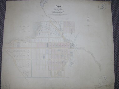
Plan, Plan of Ballarat Police Camp
Plan of Ballarat Allotments, the Ballarat Police Camp, etc.ballarat police camp, white flat co, ballarat -
 University of Melbourne, Burnley Campus Archives
Map, Map of Showgrounds, c. 1970
Tracing paper plan with grid lines. Student project? -
 Bendigo Historical Society Inc.
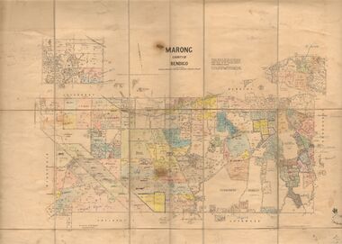
Map - JACK FLYNN COLLECTION: MARONG, June 1933
Map: Parish of Marong, County of Bendigo. Parish plan.By Authority W.M. Houston, Government Printer. Drawn and reporduced at the Dept., of Lands and Survey, Melbourne, Victoria.map, bendigo, parish plan, marong -
University of Melbourne, Burnley Campus Archives
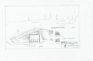
Plan, Plan of Creswick Park - Hawthorn, c. 1970
2 Photocopies of plan showing irrigation lines. No 885.creswick park, hawthorn, webb-way irrigation system -
 Warrnambool and District Historical Society Inc.
Ledger, Chadwick Copying Book Co, Letter book 1905, 1902
This letter book has maps, letters and plans dating from 1902 to 1905. It came from the office of John William Crawley, Junior, an engineer, architect and surveyor in private practice in Warrnambool and also the engineer for the Shire of Warrnambool from 1895 to 1935. His father, brother and son were all engineers and worked in that capacity or as Shire Secretary for the Shire of Warrnambool, with the Crawley family recording a total of 132 years of service to the Shire of Warrnambool. The Shire of Warrnambool existed from 1863 to 1994. This letter book was passed on to John Crawley’s son, Rolf, engineer for the Shire of Warrnambool from 1935 to 1968. The letter book then came into the possession of Michael Hand who took over the private surveying business of Rolf Crawley in Warrnambool. The Warrnambool and District Historical Society acquired the letter book, along with several other Crawley ledgers, from the Michael Hand estate. This letter book is of considerable importance as it contains the letters, maps and plans produced by John William Crawley Junior, a Shire of Warrnambool engineer for 40 years. It will be useful to researchers. This is a black hard cover letter book of 505 pages, plus an alphabetical index at the back of the book. The letter book contains handwritten letters, sketch maps and plans. There is gold lettering on the spine.‘1’ ‘Invoice’ ‘Chadwick Copying Book Co. Springfield Mass.’ john william crawley, junior, warrnambool, rolf crawley, warrnambool, shire of warrnambool, history of warrnambool -
 Federation University Historical Collection
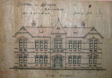
Plan, Ballarat School of Mines New Classrooms (now Administration Building), 1899, 16/02/1899
In 1900 this building was described as 'handsome in design, well lit, well ventilated, commodious - containing Council room, office, chemical laboratory, mineralogical laboratory, students room and six lecture rooms. Original hand coloured plan on linen of the Ballarat School of Mines New Classrooms (in 2014 known as the Federation University Australia SMB campus Administration Building). The plan shows the front elevation, section on line, ground and 1st floor plan. Copy in black frame with cream mount.ballarat school of mines, new classrooms, administration building, architectural plans, a building -
 Ringwood and District Historical Society
Plan, Drill Hall Site - Design for Military Units and Miniature Rifle Range, Ringwood, Victoria - Circa 1935
Technical drawings (a) Block Plan - Ringwood Drill Hall Site, Station Street, Ringwood. (b) Plan View, End and Side Elevation, Drill Hall Wodonga - Removed to Ringwood. (c) Plan View, Front and Rear Elevations, Minature Rifle Range at Ringwood Drill Hall.Commonwealth of Australia. Department of The Interior, Works & Services Branch, Victoria. -
Port Melbourne Historical & Preservation Society
Audio - PMHPS Meeting, John THWAITES, Deputy Premier of Victoria, Glen Stuart, 28 Aug 2000
Recording of PMHPS Meeting on 25.09.2000. Recording done by Glen STUART at Port Town Hall. Speaker was John THWAITES, Planning Minister and Deputy Premier of Victoria, Minister for Planning and Health. Discussing heritage, Planning and development. Tape duration 0:35:01 including member's questionsbuilt environment, town planning, town planning, heritage, john thwaites -
University of Melbourne, Burnley Campus Archives
Plan, Circus Site, c. 1990
(1) Copy of Plan: City of Richmond City Engineers Department Circus Site: includes Descriptions of Site Preparation, Plant List and Plant Order List. (2) On tracing paper: Plant Plan. (3) On tracing paper: "Yarra Vegetation Survey - Site 3," Plant Plan(1) Handwritten on reverse, "Richmond Council - Yarra Blvd to Bridge Road."circus, survey -
 Kew Historical Society Inc
Plan - Subdivision Plan, Jas R Mathers Son & McMillan, Eastlawn Estate : East Kew Auction Sale, 1914
The Kew Historical Society's map collection includes a substantial number of real estate subdivision plans, mainly of Kew but also of surrounding suburbs in Melbourne. Most of the subdivision plans date from the 1920s and 1930s when the districts old homes and local farmland were being split up to accommodate residential growth in the postwar period. These early plans were assembled by a local firm, Jas R Mather & McMillan, which had an office in Cotham Road. Many of the plans, and sometimes photos, were annotated by the agents.Subdivision plans are historically important documents used as evidence for the growth of suburbs in Australia. They frequently provide information about when the land was sold as well as evidence relating to surveyors and real estate and financial agents. The numerous subdivision plans in the Kew Historical Society's collection represent working documents, ranging from the initial sketches made in planning a subdivision to printed plans on which auctioneers or agents listed the prices for which individual lots were sold. In a number of cases, the reverse of a subdivision plan in the collection includes a photograph of a house that was also for sale by the agent. These photographs provide significant heritage information relating house design and decoration, fencing and household gardens.The photograph may also be aesthetically significant depending on the importance of the photographic atelier.The ‘Eastlawn Estate’ was surveyed and ready for auction in March 1914, three months before the outbreak of World War I. Sixty-six allotments, created on the ‘order of Mr & Miss Preston’ surrounded the mansion of Woodlands in Harp Road. Woodlands formed part of the Estate, being advertised as lot 1. The allotments faced High, Station and Wright Streets, Harp and Normanby Roads, and Woodlands Avenue. Pru Sanderson in the Kew Conservation Study (Vol.2, 1988) wrote that the Eastlawn Estate ‘covered the western half of the failed Harp of Erin Estate’. Contemporary advertisements promoted the Eastlawn Estate as: ‘There will be no more convenient district nor pleasant Suburb than East Kew for the busy business man. When the Electric Tram is laid, he will be able to journey quickly and pleasantly direct from Collins Street to his home in the Eastlawn Estate in about 20 minutes’. The actual plans of subdivision were included in advertisements in The Argus and in the local newspapers."C" top left. Various annotations.subdivision plans - kew, station street, normanby road, high street, woodlands avenue, harp road, woodlands - kew -
Glen Eira Historical Society
Document - Glenhuntly Park Estate
... Plans ...This file contains three items: 1/Photocopy (2 pages) of plan for Glenhuntly Park Estate, showing Lyons and Morgan Streets. Includes photocopied photos of Glenhuntly shopping strip in Glenhuntly Road. 2/Photocopy (2 pages) of advertisement for Glenhuntly Park Estate. Includes photocopied photos of Carnegie and Glenhuntly shopping strips. 19/03/1988. 3/Photcopy (2 pages) of plan for Glenhuntly Park Estate; includes Miller and Morgan Streets. Also photocopied photo of Miller Street.glenhuntly park estate, glenhuntly road, lyons street, morgan street, moira avenue, koornang road, miller street, neville street, caulfield, glenhuntly, carnegie, elsternwick, land subdivision auctions, villas, trams, plans, estate, messrs robert best & hooper solicitors -
 Ringwood and District Historical Society
Article - Newspaper Clipping, Land Sale Advertisements, Golden Hill Estate, Ringwood - 1965, 1966, and Plan of Survey of Lot 8, Mullum Mullum Road Ringwood, 1970
Newspaper clippings from Melbourne Sun newspaper (11th December 1965 and 15th January 1966) advertising sale of land - Golden Hill Estate, Ringwood, with summary of features and aerial photograph including artistic representation of street layout. Subdivision includes Mullum Mullum Road, Sonia Street, Jill Court, Linda Drive, Eve Court, Alma Court, and Jacynthe Court. Attachments include reference to Lot 46 as site of original Peter Vergers' orchard residence and subsequent 1970 surveyor's Plan of Survey of Lot 8 Mullum Mullum Road Ringwood, LP 67513, Cert of Title 8581/429.Agent - Aaron, King & Co., Suite 2, 33 Queens Road, Melbourne. (Phone) 26-2443, A.H. 850-2195. Plan of Survey signed on 25.7.1970 by Roger M. Gamble, Land Surveyor, 28 Summit Crescent, Ringwood 3134. -
 Bendigo Historical Society Inc.
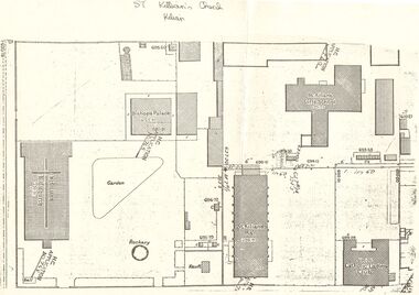
Document - PLAN OF THE AREA SURROUNDING: ST. KILIAN'S CHURCH
Plan of area surrounding St. Kilian's Church showing location of church, Bishop's Palace, and Vault, position of the Bell,. St. Kilians Girls School, St. Kilians Hall and the Catholic Ladies Club building. Plan is over stamped in a number of places with ''H.C. Application No 765'' and appears to have spot heights and indication of slope in two places (''I in 60''). No indication on plan of scale of plan. No date.church, history, st. kilian's catholic church, bendigo, bishops palace, ladies club building, st kilian's hall. -
Bendigo Historical Society Inc.
Plan - MCCOLL, RANKIN AND STANISTREET COLLECTION: PLAN OF MONUMENT HILL BATTERY
Pale blue waxed paper plan. Written on back of plan ' Monument Hill Battery site, area desired by Bendigo Mines ( Nell Gwynne) for disposal of mullock. Plan shows Ophir Street, Rowan Street, Written on bottom RH corner 'Bendigo Mines Ltd., surface plan, vicinity Nell Gwynne Shaft, Scale 1" = 40' Magnetic north marked, sand dumps and contour lines.bendigo, business, mccoll, rankin & stanistreet -
 Bendigo Historical Society Inc.
Document - BERT GRAHAM COLLECTION: PLANS FOR BENDIGO EAST, 2/12/1957
Documents, Bert Graham Collection, (a) Plan for Kennedy Street Reconstruction, Lansell Street, Charleston Road. Plan drawn by City of Bendigo, City Engineer on 18 May 1976.(b) Plan for Brick dressing pavilion at Eastern Park, Bendigo, by City of Bendigo Engineer, R. Anderson, date 2/12/1957. ( c ) Plan for Swimming Pool. Parts (a) and (b) have not been scanned because of their size.bendigo, clubs, bendigo east swimming club -
University of Melbourne, Burnley Campus Archives
Plan - Photocopy, Plan - Additions to Plant Research Laboratory (1) , Extension to Plant Research Laboratory for the Department of Agriculture, Burnley Gardens (2 & 3), 1953
University of Melbourne Property and Services has better copies Photocopies, reduced in size, of original plans. Signed by Dept of Public Works, Chief Architect. (1) and (2) dated 14.08.1953 (1) UCB.2.123 North Elevation, Perspective Sketch, Plan. (2) UCB.2.142₃ Floor plan. (3) UCB.2.157.0, dated 26.11.53, South Elevation Front (North) Elevation, West Elevation, Plan, Sections ₂. University of Melbourne - Property and Services has a better copy.plant research, laboratories -
University of Melbourne, Burnley Campus Archives
Plan, Property and Campus Services Architectural Services, Centenary Hall Burnley Campus Proposed Fitout, 19.08.2013
centenary building, dairy, university of melbourne, renovation -
 Melbourne Tram Museum
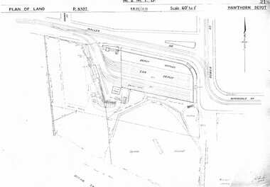
Drawing, Melbourne & Metropolitan Tramways Board (MMTB), "Hawthorn Depot", c1937
Set of three photocopied plans or drawings on A3 sheet of "Hawthorn Depot" - c 1938 .1 - P8392 - Plan of land showing Depot, surrounding land and streets - 2 copies held .2 - P8393 - Plan showing detail layout of depot, buildings and fences - 2 copies held .3 - P8394 - Plan showing detail of offices and basement Drawings 2 and 3 show substation location.trams, tramways, drawings, depots, property, hawthorn depot, substation -
 City of Whittlesea
Document - Correspondence, Station Entrance and Railway Platform Estate, 1937
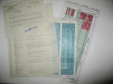
Letter from Ellison, Hewison & O'Collins Solicitors, Melbourne to the Shire of Whittlesea in reponse to a request for the names and addresses of the purchasers of blocks of land on the Station Entrance Estate and Railway Platform Estate, Thomastown. Both estates where originally subdived and sold in the mid 1920s. The collection includes a letter, a list of owners and their address details and the lot they own, and plans of both estates, which have been cut out of the original estate sale posters. Streets include High Street (Epping Road), Mount View Road, Pleasant Road, Central Avenue, Highlands Road and Main Street, ThomastownLetter, paper 3 pages, 2 plans. Letter from Ellison, Hewison & O'Collins Solicitors, Melbourne to the Shire of Whittlesea in reponse to a request for the names and addresses of the purchasers of blocks of land on the Station Entrance Estate and Railway Platform Estate, Thomastown. -
 Warrnambool and District Historical Society Inc.
Document (Sketch Plan of Dunmore), Stan Baulch, 1972
This card has a sketch map showing the properties surrounding Dunmore on one side and a detailed sketch plan of Dunmore homestead in the early 1970s on the other side. The plan of Dunmore homestead shows interesting features such as the brick oven for bread making, the croquet lawn, the site of the aboriginal mia mias, the Turkish baths and the fowl house used later as a poison house. Francis and Ann Baulch were pioneer settlers in the Kirkstall area and their son Samuel worked at Dunmore in the Macarthur area before purchasing in the early 1870s the property he named Rose Park. In the 1890s he acquired property in the Dunmore estate and his son Stan Baulch gained a section of the Dunmore property after his father’s death. Stan Baulch named this Dunmore section, Rose Park, a property to the west of his father’s original Rose Park property. Stan Baulch was a long time member of the Warrnambool & District Historical Society and he contributed many local history articles and donated many local artefacts to the Society.This sketch plan is of interest as it tells us what the historic homestead of Dunmore in Western Victoria was like in the early 1970s. It will be useful for research. This is a sheet of white lightweight cardboard with a pencilled sketch on one side and a blue ink sketch plan of a house on the other side. The edges of the card have some torn sections. The card is enclosed in an oval cardboard cylinder (recycled and torn at the ends). Both the card and the cover have handwritten titles in ink. Dunmore Homestead & History by S. Baulch Dunmore Homestead drawn by Stan Baulch c.1972 dunmore property, western victoria, baulch family -
Ringwood and District Historical Society
Newsletter, Enjoying Planned Retirement Newsletters June 2010, Jun-10
EPR was incorporated in December 20027 A4 pages printed double sided - News of EPR Inc Newsletter - June 2010 - Enjoying Planned Retirement +Additional Keywords: EPR / Enjoying Planned Retirement -
Bendigo Historical Society Inc.
Plan - JAMES LERK COLLECTION: BENDIGO HISTORIC SOCIETY FEATURE PLAN OF VICTORIA HILL AREA COMPILED BY AHQ SURVEY REGIMENT MAY 1971
Paper plan produced for the Bendigo Historic Society Victoria Hill Area Compiled by AHQ Survey Regiment May 1971 plan with black print, has been rolledAHQ Survey regiment -
 Bendigo Historical Society Inc.
Document - PLANS FROM LAND OFFICE , BENDIGO
Royal Historical Society of Victoria Bendigo and district branch. Plans from Land office, Bendigo. Four pages listing of parishes and two pages listing of Township plans. -
Port Melbourne Historical & Preservation Society
Plan - Port Melbourne Life Saving Club, Graeme Bentley Landscape Architects, Mar 1993
.01 - Plans and landscape drawings for Port Melbourne Life Saving Club, March 1993, 10pp .02 - One sheet "Landscape Master Plan" Port Melbourne Foreshorenatural environment - beaches and foreshore, built environment - recreational facilities, societies clubs unions and other organisations, graeme bentley - landscape architects -
Port Melbourne Historical & Preservation Society
Plan - Rebuilding library, Liardet Street, Port Melbourne, Linkon Design and Construction, 1987
.01 - Blueprint of 1987 plan for rebuilding library in Liardet Street (2 copies). .02 - Blueprint of 1987 Plan for Library in Liardet St - Electrical Services (2 copies)market reserve, linkon, city of port melbourne engineering dept, port melbourne library, built environment - civic, liardet street -
Port Melbourne Historical & Preservation Society
Plan - Port Melbourne Planning Scheme, Bayside Project Area, Development Plan. Comprehensive Development Zone No. 9 (Bayside Project Area). Local Section Port Melbourne Planning Scheme, Apr 1990
Development Plan. Comprehensive Development Zone No. 9 (Bayside Project Area). Local Section Port Melbourne Planning Scheme. 1990. Large white spiral bound folder.town planning - proposals shelved - bayside, local government - city of port melbourne, built environment, sandridge city development co pty ltd, scdc, beacon cove, mirvac -
Port Melbourne Historical & Preservation Society
Document - Specification, Metalling and chanelling, Danks Street from Esplanade East to Boundary Street South, Engineering Department, Town of Port Melbourne, 14 Mar 1893
Specification for metalling and channelling Danks Street from Esplanade East to Boundary Street South (Pickles Street) Loan Works 1893 plan 19; relates to plan 98.2Signed by JJ Bartlett (Mayor) 14.3.1893engineering - roads streets lanes and footpaths, town planning, town clerks, mayors, arthur victor heath, james john bartlett -
Port Melbourne Historical & Preservation Society
Plan - Metalling and channelling Danks Street from Esplanade East to Boundary Street South, Engineering Department, Town of Port Melbourne, 14 Mar 1893
Plan for metalling and channelling Danks Street from Esplanade East to Boundary Street South (Pickles Street) Loan Works 1893 plan 19; relates to specification 98.1Signed by JJ Bartlett (Mayor) 14.3.1893engineering - roads streets lanes and footpaths, town planning, town clerks, mayors, arthur victor heath, james john bartlett -
University of Melbourne, Burnley Campus Archives
Plan, Plant Culture and Garden Maintenance Planting Plan Assignment, 1987-1988
(1) Plan on tracing paper of Mixed Border, plants not included, signed MG March '87. (2) Base Plan by MG, July 1988. Scale 1:100.gardens, maintenance, planting -
University of Melbourne, Burnley Campus Archives
Plan, ACM Landscape Architecture, Courtyard & Entrance, 1995
Photocopies of sketches of Set out plan, Planting plan & surface finishes details. Typed description of works by ACM Landscape Architecture. Not sure if this relates to Burnley or is Student work.acm landscape architecture, burnley, courtyard garden