Showing 2091 items
matching bendigo maps
-
 Bendigo Historical Society Inc.
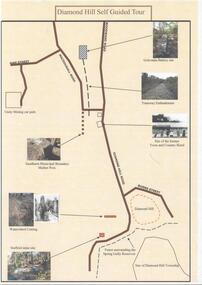
Document - DIAMOND HILL SELF GUIDED TOUR
One page coloured map of historical sites in the Diamond Hill area. Including the Golconda Battery site, Tramway Embankment, site of former Town and Country Hotel, Sandhurst Municipal Boundary Marker Post, Waterwheel Cutting, Stafford Mine site. On the back a description of the various sites. Produced by the Bendigo Historical Societybendigo, tourism, diamond hill -
 Bendigo Historical Society Inc.
Book - BENDIGO NATIONAL SWAP MEET 1990 SOUVENIR GUIDE, 1990
64 page soft cover book 'Bendigo National Swap Meet Nov.1990 Souvenir Guide' Price $3.00 Includes colour and B&W photos. List of exhibitors with map. Photo of a 1929 Ford A Tourer on front cover.Tony Spurling Editor -
 Bendigo Historical Society Inc.
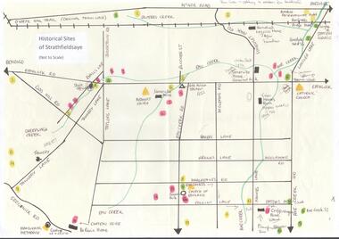
Map - MAP OF HISTORICAL SITES OF STRATHFIELDSAYE
On one side a map of the historical sites of Strathfieldsaye (not to scale) and on the other ten photographs of people and sites and a list of the sites marked on the map.bendigo, history, strathfieldsaye -
Bendigo Historical Society Inc.
Book - BENDIGO'S VINTAGE TALKING TRAMS, 1996
100 page soft cover booklet describing the history of the Bendigo tramways. Includes a brief history of Bendigo, illustrated descriptions of the tramways fleet, map of the talking tram route and a script for the tram tour. Edited by Keith S Kings. Published by the Bendigo Trust, December 1996 and printed by Bendigo Modern Press. Signed by Keith Kings 20/2/97 Copy originally owned by RW & M Birrell Inside front cover are 2 tickets for the inaugural tram trip of the restored tram No. 7Keith S Kings -
 Bendigo Historical Society Inc.
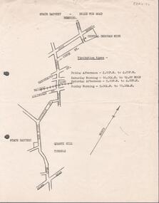
Document - ALBERT RICHARDSON COLLECTION: STATE BATTERY BELLE VUE ROAD, BENDIGO
One page document with map sowing the location of the State Battery Quarry Hill. Visitation times are given, presumably it was a tourist destination.bendigo, mining, state battery -
Bendigo Historical Society Inc.
Book - A BRIEF HISTORY AND REMINISCENCE OF LONG GULLY, 2000
66 page soft cover booklet 'A Brief History and Reminiscence of Long Gully' by George A. Ellis. Printed June 2000 and published by George Ellis. Addendum for page 9 at back cover. Illustrated with B&W photosand map.George A.Ellis -
Bendigo Historical Society Inc.
Book - GOLD ESCORT, 1971
228 page hardcover book by :L.J.Blake entitled 'Gold Escort' The story of how thousands of pounds of gold were sent in escorted wagons from the gold fields at Mt Alexander to South Australia. Emphasis on the Gold Commissioner Alexander Tolmer. Illustrated with B&W photos and maps inside front and back covers. First published and printed 1971 by The Hawthorn Press Pty Ltd.L.J.Blake -
Bendigo Historical Society Inc.
Book - TOURING SACRED MINE SIGHTS OF BENDIGO, 1994
16 page booklet 'Touring Sacred Mine Sights of Bendigo' Produced by Bendigo Mining and the Victorian Chamber of Mines.1994. Researched and written by David Horsfall and printed by Bendigo Modern Press. Details and suggested walking and driving tours of old mine sites. Includes 3 maps.David G Horsfall -
 Bendigo Historical Society Inc.
Flyer - HUGH ENNIS COLLECTION: FLYER SHOWS LOCATION MAP FOR THE OPENING OF THE BENDIGO MARKETPLACE ON TUESDAY 31ST OCTOBER 1995, 31/10/1995
Flyer shows location map for the opening of the Bendigo Marketplace on Tuesday 31st October 1995 -
 Bendigo Historical Society Inc.
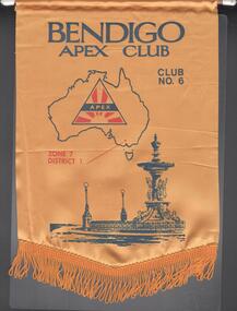
Banner - JOHN WILLIAMS COLLECTION: BENDIGO APEX CLUB
Yellow banner of Bendigo Apex Club. Club No.6, zone 7, district 1. The banner has a map of Australia with the Apex logo in it and a drawing of Alexandra fountain.bendigo, clubs, apex -
 Bendigo Historical Society Inc.
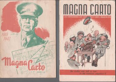
Magazine - THE BROOK AND ANDERSON FORTUNA COLLECTION: MAGNA CARTO MAGAZINE
Two copies of the Magna Carto Magazine of the Australian Survey corps. Issue two and four. Issue two has a drawing of a soldier and a map and compass with the words 1910-1943 on the cover. Issue four has a group of soldiers around a table with the words ''the duffer who left a tree in the contour negative!!''.military, world war 2 -
Bendigo Historical Society Inc.
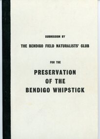
Document - PETER ELLIS COLLECTION: SUBMISSION BY THE BENDIGO FIELD NATURALIST CLUB FOR THE PRESERVATION OF THE WHIPSTICK 1985 OVERHEAD PROJECTOR PRESENTATION, 1985
PETER ELLIS COLLECTION: SUBMISSION BY THE BENDIGO FIELD NATURALIST CLUB FOR THE PRESERVATION OF THE WHIPSTICK 1985 Overhead Projector Presentation Collection of projector overheads, maps and notes.person, individual, peter ellis oam -
 Bendigo Historical Society Inc.
Document - PETER ELLIS COLLECTION: SUBMISSION BY THE BENDIGO FIELD NATURALIST CLUB FOR THE PRESERVATION OF THE WHIPSTICK 1971, 1971
PETER ELLIS COLLECTION: Submission by The Bendigo Field Naturalist Club for the Preservation of the Whipstick Bendigo 1971 The submission was sent to the Minister for Forests. 'On behalf of the Bendigo Field Naturalist's Club, we, the President and Honorary Secretary, make application to the Forests Commission to have two areas, as approximately shown in green on the maps submitted (under separate cover), and being in the parishes of Huntly Nerring and Whirakee, Edgerton declared as Forest Parks under the Appropriate Act.' The Submission has the following contents: Bendigo's Claim for a Forest Park or National Park The Proposed Foiorest Parks Near Bendigo The Flora of The Proposed Whipstick Forest Park Species of Native Plants Bendigo Whipstick Area 1971 Species of Birds Bendigo Whipstick Area 1971 Mammals of the Whipstick Historical Bendigo Whipstick Statisticsperson, individual, peter ellis oam -
 Bendigo Historical Society Inc.
Document - BIG HILL TUNNEL DESCRIPTION
Description of the Big Hill Tunnel, why it was built and David Ogilvie who worked on it with a detailed map of the area.bendigo, planning, big hill tunnel -
Bendigo Historical Society Inc.
Map - REPORT ON THE BENDIGO GOLDFIELD CENTRAL AREA
... , Bendigo, Victoria, 15th November, 1916. Map REPORT ON THE BENDIGO ...Report, 24 pages, on the Bendigo Goldfield in 1916. On front cover 'This report is the outcome of an investigation into the present condition and future prospects of the Central Area of the Bendigo Goldfield, undertaken with a view to seeing what improved methods could be adopted in the conduct of mining operations to neutralise the recent heavy increase in the cost of labour and mining requisites, and so restore the industry to the level of its previous prosperity' Signed by E.C. Dyason, B.Sc. Commonwealth Chambers, Bendigo, Victoria, 15th November, 1916.Geological Survey Victoriabendigo, gold mining, report on goldfield -
Bendigo Historical Society Inc.
Document - STRUCTURE OF BENDIGO GOLDFIELD BULLETIN NO. 47
Booklet, 36 pages, that describes the structure of the Bendigo Goldfield. Booklet is enclosed in an envelope. On front of booklet : 1923 Victoria, Department of Mines, Bulletins of the Geological Survey of Victoria, W. Baragwanath, Director. Structure of Bendigo Goldfield, by H. Herman, late Director of Geological Survey. Maps under catalogue number 3769 accompanied the booklet and are listed as 'plates' on the contents page. Plans and Sections to accompany Bulletin No 47, Structure of Bendigo Gold-Field, by H Herman, B.C.E., M.M.E., F.G.S., late Director of Geological Survey.Geological Survey of Victoriabendigo, gold mining, structure of goldfield, bendigo, goldfield, gold mining, geology -
Bendigo Historical Society Inc.
Map - MAP: VIRGINIA MINE GARDEN GULLY LINE OF REEF
... Victoria, Geological Survey Office, Bendigo. Map of Virginia Mine ...Map of Virginia Mine on the Garden Gully line of reef, Eaglehawk, transverse section. Shaft, levels and Garden Gully anticlinal axial line drawn. Key shows types of formations - quartz, spurs, sandstone, slate, cleavage, lava. This map forms part of the Geological Survey of Victoria, Structure of Bendigo Goldfield report, No. 47, 1923. H.Herman, late Director of Geological Survey.Geological Survey Victoria, Geological Survey Office, Bendigo.bendigo, gold mining, virgina mine eaglehawk, eaglehawk, bendigo, gold mining, virginia mine, garden gully line of reef. -
Bendigo Historical Society Inc.
Map - SECTIONS ACROSS BENDIGO GOLDFIELD
... BENDIGO Gold mining reef line maps Geological Survey of Victoria ...Map in three sections showing sections across Bendigo Gold Field, showing anticlines, synclines, faults, stratigraphical zones and mines along the reef lines. Key shows rock types Castlemaine, Bendigo B1, B2, B3 and B4, and Lancefieldian. First part of map shows sections A-A, B-B and C-C. Reef lines drawn with mines listed: Fault line shown are the Carshalton, Stafford, New Chum, Virginia and Clarence. A datum line shows 600 ft above sea level. On bottom of plan: ' Prepared in the Geological Survey Office, Bendigo, under the direction of H. Herman, late Director of Geological Survey, from surveys by H.S. Whitelaw, Field Geologist, assisted by E.S. Usher, A.J.J. Moore and R.A. Keble.' Second section of map shows sections D-D, and E-E. Fault lines listed are the Tambour Major fault, Carshalton fault, Stafford fault, Nell Gwynne fault, New Chum fault, Deborah fault. Third section shows sections F-F and G-G. Fault lines listed are the Bird Reef fault, Kangaroo Gully fault, Langdon fault, Carshalton fault, Nell Gwynne fault, Spring Gully fault, Hustlers fault, Gravel Hill fault, Ordes fault, Thanet fault. This map forms part of the Geological Survey of Victoria, Structure of Bendigo Goldfield report, No. 47, 1923. H.Herman, late Director of Geological Survey.Geological Survey of Victoriabendigo, gold mining, reef line maps -
Bendigo Historical Society Inc.
Map - BENDIGO GOLD FIELD GEOLOGICAL MAP
... BENDIGO GOLD FIELD GEOLOGICAL MAP...Geological map of the Bendigo Gold Field showing... BENDIGO Gold mining geological map Geological Survey Victoria ...Geological map of the Bendigo Gold Field showing stratigraphical zones. Map in two sections, colour coded showing anticlines, synclines, shafts, fault lines, fossils. Signed by H. Herman. This map forms part of the Geological Survey of Victoria, Structure of Bendigo Goldfield report, No. 47, 1923. H.Herman, late Director of Geological Survey.Geological Survey Victoriabendigo, gold mining, geological map -
 Bendigo Historical Society Inc.
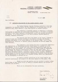
Document - LODDON - CAMPASPE REGIONAL PLANNING AUTHORITY LETTER
Two letters from the Loddon - Campaspe Regional Planning Authority the first dated 9th April, 1979 the second 12th April, 1979 both titled: annotated bibliograpghy of the Loddon-Campaspe Region. Also a map of the Loddon-Campaspe regional Autorithy area of study. Two stapled pages of the Annotated Bibliography of the Loddon - Campaspe Regionorganisation, government, loddon campaspe -
 Bendigo Historical Society Inc.
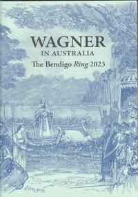
Book - WAGNER IN AUSTRALIA - THE BENDIGO RING 2023, 2023
28 page soft cover booklet entitled 'Wagner in Australia - the Bendigo Ring 2023'. Souvenir booklet to commemorate the performances of 'The Ring Cycle' at the Ulumbarra Theatre, Bendigo by Melbourne Opera. Illustrated with colour and B&W photos and maps. Published by the Melbourne Conservatorium of Music in 2023.The University of Melbourne -
Bendigo Historical Society Inc.
Document - BENDIGO AND VICTORIA HILL REPORT ON GEOLOGY
Report, 8 pages, on the geology of Bendigo district and Victoria Hill, produced by the Geological Survey Dept., Victorian Government. G.J. Medwell, Geologist. 19.10.1967. On front 'Geological Survey of Victoria. Mines Department Victoria. Report on Geology of Bendigo and of Victoria Hill Area' Letter attached inside front cover to J.C.Balfour, Minister of Mines to G.A. Lambert, Liberal Party, Sunshine, Victoria, sent with book for his information. Report contains: Cobaw batholith and North Harcourt Bendigo goldfield generally Trought, reefs, saddles and spurs Victoria Hill mines; Victoria Consols, Great Central Victoria, Victoria Quartz, Lansells 180, North Old Chum. Maps attached show part of New Chum line of reef and a handdrawn map of Rae's Cutting.bendigo, mining, victoria hill, bendigo goldfield -
Bendigo Historical Society Inc.
Book - URBAN RENEWAL PROPOSAL BOROUGH OF EAGLEHAWK
16 page spiral bound booklet ' Summary of the Urban Renewal Proposal of the Borough of Eaglehawk, December 1976' Includes proposed plan maps.Urban Renewal Authority, Melbourne -
Bendigo Historical Society Inc.
Document - GREAT EXTENDED HUSTLERS: MAPS OF HUSTLERS MINE SITE
Three maps, copies. Great Extended Hustlers mine site. Hustlers Royal Reserve No. 2 Mine. Streets around Great Extended Hustlers mine site and reserve.bendigo, mining, great extended hustlers -
Bendigo Historical Society Inc.
Book - URBAN RENEWAL PROPOSAL BOROUGH OF EAGLEHAWK
Spiral bound booklet 'Urban Renewal Proposal - Borough of Eaglehawk' December 1976 Published by Urban Renewal Authority, 150 Queen St, Melbourne. 83 pages including maps Donated by National Trust of Australia (Victoria), Central Victorian BranchUrban Renewal Authority -
 Bendigo Historical Society Inc.
Document - RALH BIRRELL COLLECTION: OLD MINING SITES WHITE HILLS
4 page typed document, prepared by Dr. Ralph Birrell, on the significance of the former mining sites on the White Hills. Document describes the 'area adjacent to the old Railway Workshops as shown on attached map'. A further addition (slip of paper, typed) to the paper describes the location of the Whiter Hills of White Hills: 1st White is east of Lake Weeroona The 2nd and 3rd White Hills are around Strickland Road, former East Bendigo Primary School, Baden/Powell Streets The 4th and 5th White Hills are east of Napier and Grace Sts The 6th White Hill is east of Plumridge Street The 7th White Hill is east of Bosquet Street. -
Bendigo Historical Society Inc.
Book - POLICEMAN RYAN'S DISAPPEARANCE WHITE HILLS BENDIGO
Booklet 80 pages Policeman Ryan's Disappearance - White Hills, Bendigo Written by Carol Holsworth - Friends of the Bendigo Cemeteries Inc 2013 Pale yellow cover with picture of Policeman Ryan. Colour and B & W images. Maps inside front and back covers.Carol Holsworth -
Bendigo Historical Society Inc.
Map - MINE LOCATION DRAWING AT VICTORIA HILL
Claims and shafts location for: Rae and co. - Noye and co. - Wittscheibe. Some additions to drawing made in pencil.mining, business -
Bendigo Historical Society Inc.
Map - TOWNSHIP OF SANDHURST MAP
... Inc. History House 11 Mackenzie Street Bendigo goldfields Map ...Map township of Sandhurst Portion B Bendigo Creek. Victoria zincographed at the Crown land's office, nos 54/21-57/12 Melbourne, April 21st 1857 (by G. Collis). -
 Bendigo Historical Society Inc.
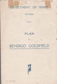
Map - BENDIGO GOLDFIELDS MAP
... BENDIGO GOLDFIELDS MAP...Map of the Bendigo Goldfield, showing reef lines, mines... BENDIGO Mining bendigo goldfields Map of the Bendigo Goldfield ...Map of the Bendigo Goldfield, showing reef lines, mines and significant geographical features such as Monument Hill, Quartz Hill and Diamond Hill. On the back of map 'Department of Mines, Victoria. Plan of Bendigo Goldfield.bendigo, mining, bendigo goldfields