Showing 126298 items
matching main-road
-
 Eltham District Historical Society Inc
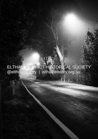
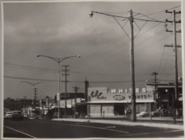
Photograph (Item) - Negative, Nick O'Brien, Main Road, Eltham at night, 1988
Nick O'Brien 1988 Entrant No. 41 Ref: Series 34, Items 17, 71-74 The images in this record were not selected for inclusion. SHIRE OF ELTHAM COMMUNITY PHOTOGRAPHIC SURVEY Photography is an artform which many of us practice, sometimes purely for artistic pursuit, sometimes to record the people and events in our lives. In 1988, as part of a local Bicentennial project, the Shire of Eltham conducted the Eltham Community Photographic Survey. Up to 100 entries were to be selected by a panel of photographers for entry into the Eltham Photographic Survey Exhibition. Entries had to be submitted by May 13, 1988. Entrants whose images were selected for the exhibition were contacted and requested to further submit an entry form providing entrant’s name, area of residence, age, and proposed captions. These details were then used to produce labels for the exhibition mounts. Where negatives had not been supplied, these were requested to support the display of printed enlargements mounted on 10” x 8” cardboard. The mounted prints were made available post exhibition for sale at $8.50 each for colour prints and $7.00 for B&W prints. Residents in the Shire were invited to collect a free roll of film and take a photograph of what they either liked or did not like about the area. A total of 160 entrants submitted multiple entries for the exhibition. Of those selected for exhibition, entrants ranged in age from 9 to 70 years. All custom colour and black and white printing for the exhibition was completed by Wattle Studios of Eltham. The Eltham Photographic Survey was jointly auspiced by the Shire of Eltham and Wattle Studios, of 953 Main Road, Eltham. The project was greatly assisted by: • David McRitchie, Media Studies Lecturer Victoria College, Rusden Campus. • Ian and Annette Toohill of Wattle Studios • Tracy Naughton, Eltham Community Arts Officer • Neville Emerson Pty. Ltd. • Superior Press, Eltham • Kodak Australasia Pty. Ltd. • Agfa Gevaert Ltd. • Townsend Colourtech Pty. Ltd. • The Australian Bicentennial Authority • Eleanor Bowers, Secretary, Eltham Arts Council The exhibition was placed on display in the Woolworths Arcade, Eltham between Monday June 6th and Saturday June 11, 1988. It was also intended to hold the exhibition at a venue in the Shire’s North Riding from Monday, June 20 to Friday June 24. It was then displayed at the Were Street Theatre, Montmorency from Friday, June 24 to Thursday, July 7. Series 34: Eltham Community Photographic Survey 1988 - Prints & Documentation Series consists of 117 photographs of Shire scenes taken by members of the community. Items I - 41 are larger photographs mounted on card, which were exhibited. Items 42 - 117 are unmounted copies, alternative takes and other entries. Corresponding negatives contained in Series 35: Eltham Community Photographic Survey 1988 – Negatives which consists of 267 colour and B&W negatives and one colour slide of Shire scenes taken by members of the community. The negatives are arranged by the entrant number of the photographer. The Eltham Community Photographic Survey collection is significant to the local community as it was curated by the local community - ordinary people of all ages - representing what they liked and did not like in the area where they lived. It represents an unfiltered representation of the Shire of Eltham as it was in 1988. It also represents one of many projects as part of the national programme of events and celebrations to commemorate the bicentenary. It is a time capsule of life in the 1980s of this urban and rural municipality in Melbourne's north. shire of eltham archives, bicentennial project, eltham, eltham community photographic survey, series 35, film - ilford fp4, scan - 35mm negative, nick o'brien, main road -
 Eltham District Historical Society Inc
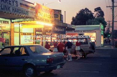
Photograph (Item) - Negative, Christina Gomilschak, Post netball pizza for dinner from Nando's Dial-a-Pizza, 935 Main Road, Eltham, 1988
Christina Gomilschak 1988 Entrant No. 42 Ref: Series 34, Items 18, 19, 75 76 The images in this record were not selected for inclusion. SHIRE OF ELTHAM COMMUNITY PHOTOGRAPHIC SURVEY Photography is an artform which many of us practice, sometimes purely for artistic pursuit, sometimes to record the people and events in our lives. In 1988, as part of a local Bicentennial project, the Shire of Eltham conducted the Eltham Community Photographic Survey. Up to 100 entries were to be selected by a panel of photographers for entry into the Eltham Photographic Survey Exhibition. Entries had to be submitted by May 13, 1988. Entrants whose images were selected for the exhibition were contacted and requested to further submit an entry form providing entrant’s name, area of residence, age, and proposed captions. These details were then used to produce labels for the exhibition mounts. Where negatives had not been supplied, these were requested to support the display of printed enlargements mounted on 10” x 8” cardboard. The mounted prints were made available post exhibition for sale at $8.50 each for colour prints and $7.00 for B&W prints. Residents in the Shire were invited to collect a free roll of film and take a photograph of what they either liked or did not like about the area. A total of 160 entrants submitted multiple entries for the exhibition. Of those selected for exhibition, entrants ranged in age from 9 to 70 years. All custom colour and black and white printing for the exhibition was completed by Wattle Studios of Eltham. The Eltham Photographic Survey was jointly auspiced by the Shire of Eltham and Wattle Studios, of 953 Main Road, Eltham. The project was greatly assisted by: • David McRitchie, Media Studies Lecturer Victoria College, Rusden Campus. • Ian and Annette Toohill of Wattle Studios • Tracy Naughton, Eltham Community Arts Officer • Neville Emerson Pty. Ltd. • Superior Press, Eltham • Kodak Australasia Pty. Ltd. • Agfa Gevaert Ltd. • Townsend Colourtech Pty. Ltd. • The Australian Bicentennial Authority • Eleanor Bowers, Secretary, Eltham Arts Council The exhibition was placed on display in the Woolworths Arcade, Eltham between Monday June 6th and Saturday June 11, 1988. It was also intended to hold the exhibition at a venue in the Shire’s North Riding from Monday, June 20 to Friday June 24. It was then displayed at the Were Street Theatre, Montmorency from Friday, June 24 to Thursday, July 7. Series 34: Eltham Community Photographic Survey 1988 - Prints & Documentation Series consists of 117 photographs of Shire scenes taken by members of the community. Items I - 41 are larger photographs mounted on card, which were exhibited. Items 42 - 117 are unmounted copies, alternative takes and other entries. Corresponding negatives contained in Series 35: Eltham Community Photographic Survey 1988 – Negatives which consists of 267 colour and B&W negatives and one colour slide of Shire scenes taken by members of the community. The negatives are arranged by the entrant number of the photographer. The Eltham Community Photographic Survey collection is significant to the local community as it was curated by the local community - ordinary people of all ages - representing what they liked and did not like in the area where they lived. It represents an unfiltered representation of the Shire of Eltham as it was in 1988. It also represents one of many projects as part of the national programme of events and celebrations to commemorate the bicentenary. It is a time capsule of life in the 1980s of this urban and rural municipality in Melbourne's north. shire of eltham archives, bicentennial project, eltham, eltham community photographic survey, series 35, carey's thrifty-link hardware, christina gomilschak, eltham shops, film - kodak ga 100 5095, nando's, scan - 35mm negative -
 Eltham District Historical Society Inc
Photograph (Item) - Negative, Jocelyn Zepter-Trevor, Entrance to the Eltham Barrel, Main Road, Eltham, 1988
Jocelyn Zepter-Trevor 1988 Entrant No. 69 Ref: Series 34, Item 24 The images in this record were not selected for inclusion. SHIRE OF ELTHAM COMMUNITY PHOTOGRAPHIC SURVEY Photography is an artform which many of us practice, sometimes purely for artistic pursuit, sometimes to record the people and events in our lives. In 1988, as part of a local Bicentennial project, the Shire of Eltham conducted the Eltham Community Photographic Survey. Up to 100 entries were to be selected by a panel of photographers for entry into the Eltham Photographic Survey Exhibition. Entries had to be submitted by May 13, 1988. Entrants whose images were selected for the exhibition were contacted and requested to further submit an entry form providing entrant’s name, area of residence, age, and proposed captions. These details were then used to produce labels for the exhibition mounts. Where negatives had not been supplied, these were requested to support the display of printed enlargements mounted on 10” x 8” cardboard. The mounted prints were made available post exhibition for sale at $8.50 each for colour prints and $7.00 for B&W prints. Residents in the Shire were invited to collect a free roll of film and take a photograph of what they either liked or did not like about the area. A total of 160 entrants submitted multiple entries for the exhibition. Of those selected for exhibition, entrants ranged in age from 9 to 70 years. All custom colour and black and white printing for the exhibition was completed by Wattle Studios of Eltham. The Eltham Photographic Survey was jointly auspiced by the Shire of Eltham and Wattle Studios, of 953 Main Road, Eltham. The project was greatly assisted by: • David McRitchie, Media Studies Lecturer Victoria College, Rusden Campus. • Ian and Annette Toohill of Wattle Studios • Tracy Naughton, Eltham Community Arts Officer • Neville Emerson Pty. Ltd. • Superior Press, Eltham • Kodak Australasia Pty. Ltd. • Agfa Gevaert Ltd. • Townsend Colourtech Pty. Ltd. • The Australian Bicentennial Authority • Eleanor Bowers, Secretary, Eltham Arts Council The exhibition was placed on display in the Woolworths Arcade, Eltham between Monday June 6th and Saturday June 11, 1988. It was also intended to hold the exhibition at a venue in the Shire’s North Riding from Monday, June 20 to Friday June 24. It was then displayed at the Were Street Theatre, Montmorency from Friday, June 24 to Thursday, July 7. Series 34: Eltham Community Photographic Survey 1988 - Prints & Documentation Series consists of 117 photographs of Shire scenes taken by members of the community. Items I - 41 are larger photographs mounted on card, which were exhibited. Items 42 - 117 are unmounted copies, alternative takes and other entries. Corresponding negatives contained in Series 35: Eltham Community Photographic Survey 1988 – Negatives which consists of 267 colour and B&W negatives and one colour slide of Shire scenes taken by members of the community. The negatives are arranged by the entrant number of the photographer. The Eltham Community Photographic Survey collection is significant to the local community as it was curated by the local community - ordinary people of all ages - representing what they liked and did not like in the area where they lived. It represents an unfiltered representation of the Shire of Eltham as it was in 1988. It also represents one of many projects as part of the national programme of events and celebrations to commemorate the bicentenary. It is a time capsule of life in the 1980s of this urban and rural municipality in Melbourne's north. shire of eltham archives, bicentennial project, eltham, eltham community photographic survey, film - agfa xr 100 i, jocelyn zepter-trevor, scan - 35mm negative, series 35, eltham barrel, main road, maple leaf band -
 Eltham District Historical Society Inc
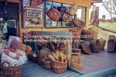
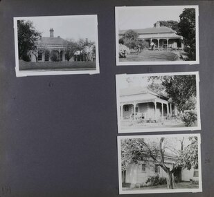
Photograph (Item) - Negative, Elizabeth Simkin, Riverclay Craft Gallery, 573 Main Road, Eltham, 1988
Riverclay was located along with Ansell and Muirs Chicken shop opposite El;tham Lower Park. The building has since been demolished as it lay within the 1934 flood plain limits. Elizabeth Simkin 1988 Entrant No. 149 Ref: Series 34, Items 39, 111-113 The images in this record were not selected for inclusion. SHIRE OF ELTHAM COMMUNITY PHOTOGRAPHIC SURVEY Photography is an artform which many of us practice, sometimes purely for artistic pursuit, sometimes to record the people and events in our lives. In 1988, as part of a local Bicentennial project, the Shire of Eltham conducted the Eltham Community Photographic Survey. Up to 100 entries were to be selected by a panel of photographers for entry into the Eltham Photographic Survey Exhibition. Entries had to be submitted by May 13, 1988. Entrants whose images were selected for the exhibition were contacted and requested to further submit an entry form providing entrant’s name, area of residence, age, and proposed captions. These details were then used to produce labels for the exhibition mounts. Where negatives had not been supplied, these were requested to support the display of printed enlargements mounted on 10” x 8” cardboard. The mounted prints were made available post exhibition for sale at $8.50 each for colour prints and $7.00 for B&W prints. Residents in the Shire were invited to collect a free roll of film and take a photograph of what they either liked or did not like about the area. A total of 160 entrants submitted multiple entries for the exhibition. Of those selected for exhibition, entrants ranged in age from 9 to 70 years. All custom colour and black and white printing for the exhibition was completed by Wattle Studios of Eltham. The Eltham Photographic Survey was jointly auspiced by the Shire of Eltham and Wattle Studios, of 953 Main Road, Eltham. The project was greatly assisted by: • David McRitchie, Media Studies Lecturer Victoria College, Rusden Campus. • Ian and Annette Toohill of Wattle Studios • Tracy Naughton, Eltham Community Arts Officer • Neville Emerson Pty. Ltd. • Superior Press, Eltham • Kodak Australasia Pty. Ltd. • Agfa Gevaert Ltd. • Townsend Colourtech Pty. Ltd. • The Australian Bicentennial Authority • Eleanor Bowers, Secretary, Eltham Arts Council The exhibition was placed on display in the Woolworths Arcade, Eltham between Monday June 6th and Saturday June 11, 1988. It was also intended to hold the exhibition at a venue in the Shire’s North Riding from Monday, June 20 to Friday June 24. It was then displayed at the Were Street Theatre, Montmorency from Friday, June 24 to Thursday, July 7. Series 34: Eltham Community Photographic Survey 1988 - Prints & Documentation Series consists of 117 photographs of Shire scenes taken by members of the community. Items I - 41 are larger photographs mounted on card, which were exhibited. Items 42 - 117 are unmounted copies, alternative takes and other entries. Corresponding negatives contained in Series 35: Eltham Community Photographic Survey 1988 – Negatives which coThe Eltham Community Photographic Survey collection is significant to the local community as it was curated by the local community - ordinary people of all ages - representing what they liked and did not like in the area where they lived. It represents an unfiltered representation of the Shire of Eltham as it was in 1988. It also represents one of many projects as part of the national programme of events and celebrations to commemorate the bicentenary. It is a time capsule of life in the 1980s of this urban and rural municipality in Melbourne's north. shire of eltham archives, bicentennial project, eltham community photographic survey, film - kodak ga 100 5095, elizabeth simkin, eltham, scan - 35mm negative, series 35, cane baskets, riverclay craft gallery -
 Phillip Island and District Historical Society Inc.
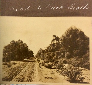
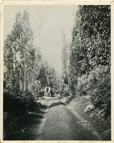
Photograph, Road to the Back Beach, 1925-1926
Sepia photograph of an rough, sandy, unmade road with trees and bushes along the side.Road to the Back Beachphotographs, phillip island early roads -
 Eltham District Historical Society Inc
Document - Property Binder, 820 Main Road, Eltham
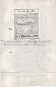
Photocopy newspaper clipping: Out of the Past, 1958, photograph of first post office at Eltham in 1880s, image owned by the Burgoyne family who had long association with the Postal Department. Photocopy Tabular Return of Post Offices in Victoria 1855-1856, including Kangaroo Ground (Andrew Ross), Little Eltham (Thomas Hunniford, Saint Andrew (William Watson). Typed newspaper article: District Roads Boards, The Argus 2 October 1867, re opening of post office savings banks and money order offices at (among others) Eltham. Index card: Thomas Hunniford, Anne Hunniford, Eltham Post Office, Eltham Telegraph Office. Letter Nillumbik Shire to Eltham District Historical Society, 9 December 2015, re Planning Application 377/2015/06P. Letter Nillumbik Shire to Eltham District Historical Society, 2 February 2016, conference re Planning Application 377/2015/06P.. Newspaper article: Beauty is in the eye of the beholder, Manningham and Nillumbik Bulletin, November 2021, re stonework on building.main road, eltham, property, businesses, eltham post office, burgoyne family, kangaroo ground post office, little eltham post office, saint andrew post office, andrew ross, thomas hunniford, william watson, anne hunniford, eltham telegraph office -
 Orbost & District Historical Society
folder, Orbost Bridges - Snowy River Road Bridges, 1974 1976
This folder was compiled in October 2015 from documents, magazines. papers and photographs donated by David Jellie, engineer in charge 1974 - 1976. In early 1974, as an Engineer with the Country Roads Board, David came to Orbost as the Supervising Engineer for the construction of the new bridges which were part of an 8.4km Orbost bypass road design. This was a major project involving not only a new bridge over the Snowy River (including Lochiel Lagoon), but other bridges over Ashby’s Gulch and Watt’s Gulch. These new bridges were opened in November 1976 with the unveiling of a plaque on the eastern end of the $2.4M Snowy River Bridge. (ref. May Leatch)This item is a useful reference tool on the construction history of the Snowy River Road bridges.A white plastic folder - Orbost Bridges - Snowy River Road Bridges. it contains newspaper articles, booklets, photographs and documents relating to the construction of the Snowy River Road Bridge in 1974 -1976.on front cover - 1974 - 76 ORBOST / SNOWY RIVER ROAD BRIDGES * construction * photos * articles * plans Donated by David Jellie Oct 2015snowy-river-bridges jellie-david -
 Stawell Historical Society Inc
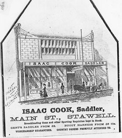
Drawing, Mr Isaac Cook, Saddler in Main Street Stawell from the P.C. News Supplement 1888 -- Sketch
Isaac Cook Saddler Main Street Line Drawing of Isaac Cook Saddler Main Street with verandah and large glass windows. Shows lady and child on footpath, man in top hat and two horse buggy with man. Details printed below diagramstawell businesses, shop -
 Glen Eira Historical Society
Album - Album page, Seymour Road, Circa 1972
This album was created in approximately 1972 as part of a project by the Caulfield Historical Society to assist in identifying buildings worthy of preservation. The album is related to a Survey the Caulfield Historical Society developed in collaboration with the National Trust of Australia (Victoria) and Caulfield City Council to identify historic buildings within the City of Caulfield that warranted the protection of a National Trust Classification. Principal photographer thought to be Trevor Hart, member of Caulfield Historical Society. Most photographs were taken between 1966-1972 with a small number of photographs being older and from unknown sources. All photographs are black and white except where stated, with 386 photographs over 198 pages. As at 22/08/2021, 61 Seymour Road is included in the HO179 Beemery Park Precinct which C204glen Amendment seeks to add to the Glen Eira Planning Scheme (amongst others). This is not yet finalised.Page 191 of Photograph Album with four photographs of two different properties on Seymour Road. One photo on the left, with the other three all on the right. Handwritten: 61 [under top left photo] / 32 [under top right photo] / 32 [beside bottom right photo] / 191 [bottom left]trevor hart, elsternwick, seymour road, late victorian, italianate style, verandahs, cast iron work, gardens -
 Mt Dandenong & District Historical Society Inc.
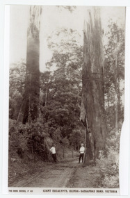
Photograph, Giant Eucalypts, Olinda-Sassafras Road. Victoria
Rose Series post card # P.69 .The Sassafras - Olinda Road showing giant Eucalypts. The two men in the photograph most probably worked for The Rose Series Post card company. They often appear in photographs - probably to give perspective.Copy of Rose Series post card P. 69 showing two men standing alongside giant trees on the Olinda-Sassafras Road.On front: THE ROSE SERIES P. 69 GIANT EUCALYPTS, OLINDA-SASSAFRAS ROAD, VICTORIA.sassafras, olinda, sassafras-olinda road, olinda-sassafras road, rose series, post cards, eucalypts, road -
 Surrey Hills Historical Society Collection
Photograph, 213 Union Road, Surrey Hills c1930, 1930
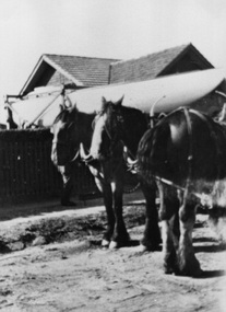
The photo shows part of the process of moving a yacht, named 'Sonia' from 213 Union Road, the home of the Fleming family. It was built in the shed garage of the house and moved from it by horse and dray. The home belonged to Harold Arthur Fleming (1891-1971) and his wife, Georgiana Phyllis (nee Griffiths: 1895-1936). Harold built the boat. They had 3 children - Eric Alexander (1918-1920), Sybil Patricia (1921-2012) and another girl. The shed /garage had been the old coach house of the adjoining property, 215 Union Road. the boat was launched at the Brighton Yacht Club. Harold was a draughtsman. The Flemings lived in a number of houses in Surrey Hills: 1. 1919 - 'Radnor' in Croydon Road; the name possibly derives from Radnorshire, Wales where Georgiana was born. 2. 1921 - 169 Union Road 3. 1931 - 213 Union Road. The donor (deceased) was the daughter of the builder and married Keith Andrew Fleming. A black & white photo with 3 draught horses in the foreground. Beyond the path and fence behind them is the roof of 213 Union Road. Between the fence and the house the view is blocked by the hull of a yacht.harold arthur fleming, miss georgiana phyllis griffiths, mrs georgiana phyllis fleming, 213 union road, horses, boating -
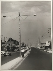
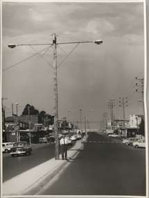
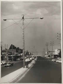
 Eltham District Historical Society Inc
Photograph, North end of the railway station carpark, Eltham, February 1968, Feb 1968
Shows the street sign for Luck Street intersection with Main Road.In February 1968 an unknown person took a series of photos from the Eltham Hotel at Pitt Street heading north along Main Road through the shopping centre to just north of Elsa Court covering the length of the section of Main Road which was duplicated shortly thereafter. Shows the condition and environment of the streesscape of Main Road, Eltham immediately prior to the duplication between Pitt Street and Elsa Court through the shopping centre. Also shows a number of shops and businesses that operated at that time.Black and white photographduplication, eltham, main road, carparks, luck street, railway station -
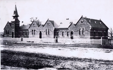 St Kilda Historical Society
Photograph, St Kilda Primary School, (BrIghton Road) 1882, c. 1882
St Kilda Primary School, (BrIghton Road) 1882, additional notes: built in 1875 On the back: Copy courtesy LaTrobe Library, Melbourne From: Archives Victoria Photographs of State School Buildings. Vol 1. State School, St Kilda (Brighton Road) Hand written: School built 1975. Tower was not moved until some time after 1882. Accompanied by a smaller copy of the same photograph.black and white photograph fair condition unmountedSt Kilda Primary School, (BrIghton Road) 1882, additional notes: built in 1875 On the back: Copy courtesy LaTrobe Library, Melbourne From: Archives Victoria Photographs of State School Buildings. Vol 1. State School, Paterson Bros. Photos. Melbourne. St Kilda (Brighton Road) 1882. School built 1975. Tower was not moved until some time after 1882. D.J Taggart 58 Glenhuntly road, Elwood 3184. St Kilda Historical Collection, 150 Carlisle street, St Kilda. -
 Stawell Historical Society Inc
Photograph, Main Street Stawell looking East with the Town Hall Hotel on the right c1890
Main street scene, Town Hall Hotel on the right. Horse drawn vehicle on left in the street. People standing under verandah on footpath. Showing W. Shorts Hotel also known as the Town Hall Hotel. Looking East up Main Street. Visible Post Office Hotel, Spragues Sporting DepotSepia photograph of a scene of Main St Stawell. Town Hall Hotel on the right. Horse drawn vehicle on left in the street. People standing under veranda in foot path. Trees in Street.Miss E. Moulden 54 Dawson St Stawell stawell shops businesses streetscape -
 Kew Historical Society Inc
Photograph, Stuart Tompkins Studio, Electricity Supply Poles, Warrigal Road, Ashwood, 1965
Research provided by Stuart Tompkins Studio, Box Hill, into alternatives for median strip street lighting to be used in Burke Road, Kew. The photographers identified variants in different suburbs appropriate to Kew's needs.The series from which the photograph is drawn provides a snapshot by a commercial photographic studio of each named vicinity in 1965 as well as providing examples of public works infrastructure being commissioned by local government in the 1960s. The photos originally formed part of the Engineering Department's files in the City of Kew before being donated to the kew Historical Society.Electricity Supply Poles, Warrigal Road, Ashwood, 1965. Stuart Tompkins Studio provided this photograph for the Kew City Council. The photograph, taken at the intersection of Warrigal Road and High Street South, Ashwood looks north along High Street Road. The intent of the photograph was to provide the Council with models of electricity supply poles. In the photo, wooden and steel poles can be seen in the median strip. The photograph also includes the shops bordering High Street Road during this period. [There are three copies of this photograph in the Collection.]. Typed inscription on reverse: "Electricity Supply Poles. Photographed for Kew City Council 8/2/65. No.4 Warrigal Road - Ashwood. South of High Street Road looking north. Wooden and steel poles with different brackets in median strip." Studio stamp: "Stuart Tompkins Studio. 547 Station Street, Box Hill. WX1439."electric light poles, public works -- 1960s, civic infrastructure -- 1960s -
 Kew Historical Society Inc
Photograph, Stuart Tompkins Studio, Electricity Supply Poles, Warrigal Road, Ashwood, 1965
Research provided by Stuart Tompkins Studio, Box Hill, into alternatives for median strip street lighting to be used in Burke Road, Kew. The photographers identified variants in different suburbs appropriate to Kew's needs.The series from which the photograph is drawn provides a snapshot by a commercial photographic studio of each named vicinity in 1965 as well as providing examples of public works infrastructure being commissioned by local government in the 1960s. The photos originally formed part of the Engineering Department's files in the City of Kew before being donated to the kew Historical Society.Electricity Supply Poles, Warrigal Road, Ashwood, 1965. Stuart Tompkins Studio provided this photograph for the Kew City Council. The photograph, taken at the intersection of Warrigal Road and High Street South, Ashwood looks north along High Street Road. The intent of the photograph was to provide the Council with models of electricity supply poles. In the photo, wooden and steel poles can be seen in the median strip. The photograph also includes the shops bordering High Street Road during this period. [There are three copies of this photograph in the Collection.]. Typed inscription on reverse: "Electricity Supply Poles. Photographed for Kew City Council 8/2/65. No.4 Warrigal Road - Ashwood. South of High Street Road looking north. Wooden and steel poles with different brackets in median strip." Studio stamp: "Stuart Tompkins Studio. 547 Station Street, Box Hill. WX1439."electric light poles, civic infrastructure - 1960s, public works -- 1960s -
 Kew Historical Society Inc
Photograph, Stuart Tompkins Studio, Electricity Supply Poles, Warrigal Road, Ashwood, 1965
Research provided by Stuart Tompkins Studio, Box Hill, into alternatives for median strip street lighting to be used in Burke Road, Kew. The photographers identified variants in different suburbs appropriate to Kew's needs.The series from which the photograph is drawn provides a snapshot by a commercial photographic studio of each named vicinity in 1965 as well as providing examples of public works infrastructure being commissioned by local government in the 1960s. The photos originally formed part of the Engineering Department's files in the City of Kew before being donated to the kew Historical Society.Electricity Supply Poles, Warrigal Road, Ashwood, 1965. Stuart Tompkins Studio provided this photograph for the Kew City Council. The photograph, taken at the intersection of Warrigal Road and High Street South, Ashwood looks north along High Street Road. The intent of the photograph was to provide the Council with models of electricity supply poles. In the photo, wooden and steel poles can be seen in the median strip. The photograph also includes the shops bordering High Street Road during this period. [There are three copies of this photograph in the Collection.]. Typed inscription on reverse: "Electricity Supply Poles. Photographed for Kew City Council 8/2/65. No.4 Warrigal Road - Ashwood. South of High Street Road looking north. Wooden and steel poles with different brackets in median strip." Studio stamp: "Stuart Tompkins Studio. 547 Station Street, Box Hill. WX1439."electric light poles, public infrastructure -- 1960s, civic works -- 1960s -
 Eltham District Historical Society Inc
Photograph - Digital Photograph, Alan King, Former CBA bank, Main Road, Eltham, 26 January 2008
This tiny picturesque building near the corner of John Street has served the community since 1878. At that time it served as an agency of the Heidelberg branch of the Commonwelath Bank of Australia. It has a small space inside measuring about 3.6 metres by 4.5 metres. It was built by George Stebbing who was also responsible for other heritage buildings nearby in Eltham. Covered under Heritage Overlay, Nillumbik Planning Scheme. Published: Nillumbik Now and Then / Marguerite Marshall 2008; photographs Alan King with Marguerite Marshall.; p93 The tiny picturesque building on Main Road, Eltham, near the corner of John Street, has served the community since 1878. At that time the building, which inside measures only about 3.6m by 4.5m served as an agency of the Heidelberg branch of the Commercial Bank of Australia. The yellow and orange Victorian brick structure was built by Mr George Stebbing.1 Mr Stebbing, who also built the Anglican and former Methodist churches and the Shillinglaw Cottage, had come from England and lived in Pitt Street. The bank is a fine example of a once common but now rare building style – the single room bank. It compares with another in the municipality, also a former Commercial Bank of Australia branch, the timber Little Bank Building in Hurstbridge, built around the early 1900s.2 The Eltham bank, which was said to store gold from the Eltham - Research mining areas, has had exciting moments. A bullet hole still visible in a cedar bench testifies to the drama in 1949 when a youth held up the bank. After the 19-year-old opened an account as John Henderson, he walked to the door and then turned pointing a pistol. But it was shots fired by the clerk, Lindsay Spear, that saved the day, frightening the youth, who drove off empty-handed in a grey sports car. He was later apprehended and given a two-year sentence. Soon afterwards the agency was upgraded to a branch. However by 1954 the bank no longer needed the branch and the adjoining Methodist Church bought the building. It proved useful for the Church’s young people who furnished it and used it for their meetings. A youth club developed, led by young adult member, Ross Gangell. The building was also used as a Sunday School, which with junior membership numbered 27.3 Around 1960, Mrs Alma Bell, of the Methodist Church Women’s Guild, suggested using the building as an opportunity shop to raise funds for a chaplain at the Eltham High School. The women later asked the nearby St Margaret’s Anglican Church to help them in the shop. In 1960 the Eltham Combined Churches Opportunity Shop was established and staffed by Methodist and Anglican parishioners, notably Methodist Mrs Gwen Miller. The shop originally opened on Child Endowment Days to help the needy, but later for years, it opened twice a week. In 1962 it donated clothing and shoes to the Eltham Bushfire Appeal. By 1963 the chaplaincy scheme ceased. So the £450 raised was then donated to the Council for Christian Education and to the participating churches. Funds were also donated to local charities including the Eltham and Research Fire Brigades, the Austin Hospital Auxiliary, the Benevolent Society, the Red Cross and the Diamond Valley Hospital.4 In 2008 the Opportunity Shop volunteers continue to work together to help the local community. Although crammed with second-hand goods, the simple, almost stark interior, is still evident and is relieved only by a front rectangular window and an unused fireplace. Outside, the chimney, the corrugated iron peaked roof, and the surrounding varied plants, add to the charm of this sound building which continues to serve the community well.This collection of almost 130 photos about places and people within the Shire of Nillumbik, an urban and rural municipality in Melbourne's north, contributes to an understanding of the history of the Shire. Published in 2008 immediately prior to the Black Saturday bushfires of February 7, 2009, it documents sites that were impacted, and in some cases destroyed by the fires. It includes photographs taken especially for the publication, creating a unique time capsule representing the Shire in the early 21st century. It remains the most recent comprehenesive publication devoted to the Shire's history connecting local residents to the past. nillumbik now and then (marshall-king) collection, cba bank -
 Mt Dandenong & District Historical Society Inc.
Photograph, Jeeves Coach on CRB Road at Foot of Farringdon Road Kalorama, 1920, 1920
Scene looking down Farringdon Road showing Jeeves horse drawn coach going along the CRB road (Mt Dandenong Tourist Road) in 1920. Detailed inscription on the back handwritten by John Lundy-Clarke in 1974.Jeeves Coach on CRB road at foot of Farringdon Road Kalorama (Mt Dandenong North) 1920. Road was formed most of the length from Montrose by contractors Bladin and Dick employing Robert Logan the younger, in 1919 and lay unmetalled till metalled by the contractors in 1922. Mountain ash trees in foreground were on Thomas Hand’s original 23 acre holding. Those beyond coach were on Isaac Jeeves original 160 acre holding Selection Crown Allotment 925(B). This was the area forming part of the inheritance lost by John William Richardson because of the expense of his wife’s illness. Hand enlarged his 23 acres to 305 in 1874. William and his family grew large crops of raspberries on his area, part of which is in the foreground. It had been cleared by his father’s employees before 1877. The section below the Main Road was cultivated by Fred hand, son of William and grandson of Thomas in the twenties before he moved to Redcliffes where he is today (1974). Comment by John Lundy-Clarke 10.5.1974 coach service, jeeves, crb road, farringdon road, kalorama, mt dandenong north, mt dandenong tourist road, john lundy-clarke, coach -
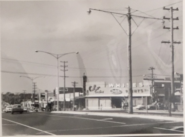
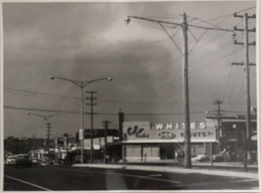
 City of Kingston
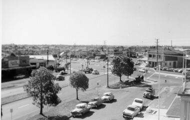
Photograph - Digital image, Black and white, Roads - Junction of Nepean Highway and South Road, c. 1950
Junction of Nepean Highway and South Road, Moorabbin - Moorabbin Hotel on right. Shops in centre demolished for road widening in 1980'sBlack and white image of Nepean Highway and South Road junction point of view from Kingston Town HallPrinted in black text a round white sticker: 234 Handwritten in red ink 80% Yellow post it note written in blue ink: CHAP 7 234 / - Nepean Hwy + South Roadnepean highway, south road, moorabbin, moorabbin hotel -
 Kew Historical Society Inc
Photograph, Stuart Tompkins Studio, Electricity Supply Poles, North Road, Ormond, 1965
Research provided by Stuart Tompkins Studio, Box Hill, into alternatives for median strip street lighting to be used in Burke Road, Kew. The photographers identified variants in different suburbs appropriate to Kew's needs.The series from which the photograph is drawn provides a snapshot by a commercial photographic studio of each named vicinity in 1965 as well as providing examples of public works infrastructure being commissioned by local government in the 1960s. The photos originally formed part of the Engineering Department's files in the City of Kew before being donated to the kew Historical Society.Electricity Supply Poles, North Road, Ormond, 1965. Electricity supply poles photographed for the Kew City Council by Stuart Tompkins Studio. The photograph of North Road, Ormond west of Jasper Road, looking east depicts wooden poles carrying two lamps in a median strip and with two on each side alternately. It was noted that the supply wires were from one side only. The poles were described as 3′ above ground and 11.25″ in diameter. The plan was to use this approach for Burke Road, Kew. [There are three copies of this photograph in the Collection.] Typed inscription on reverse: "Electricity Supply Poles. Photographed for Kew City Council 8/2/65. No.1 North Road - Ormond, west of Jasper Road, looking east. Wooden poles carrying two lamps in median strip and two on each side alternately just as is proposed for Burke Road, Kew. Supply wires from one side only. Poles 3' above ground 11 1/4" dia." Studio stamp: "Stuart Tompkins Studio. 547 Station Street, Box Hill. WX1439."stuart tompkins studio, street lighting, south road (moorabin) 1965, public infrastructure -- city of kew, city of kew -- engineer's department -
 Kew Historical Society Inc
Photograph, Stuart Tompkins Studio, Electricity Supply Poles, North Road, Ormond, 1965
Research provided by Stuart Tompkins Studio, Box Hill, into alternatives for median strip street lighting to be used in Burke Road, Kew. The photographers identified variants in different suburbs appropriate to Kew's needs.The series from which the photograph is drawn provides a snapshot by a commercial photographic studio of each named vicinity in 1965 as well as providing examples of public works infrastructure being commissioned by local government in the 1960s. The photos originally formed part of the Engineering Department's files in the City of Kew before being donated to the kew Historical Society.Electricity Supply Poles, North Road, Ormond, 1965. Electricity supply poles photographed for the Kew City Council by Stuart Tompkins Studio. The photograph of North Road, Ormond west of Jasper Road, looking east depicts wooden poles carrying two lamps in a median strip and with two on each side alternately. It was noted that the supply wires were from one side only. The poles were described as 3′ above ground and 11.25″ in diameter. The plan was to use this approach for Burke Road, Kew. [There are three copies of this photograph in the Collection.] Typed inscription on reverse: "Electricity Supply Poles. Photographed for Kew City Council 8/2/65. No.1 North Road - Ormond, west of Jasper Road, looking east. Wooden poles carrying two lamps in median strip and two on each side alternately just as is proposed for Burke Road, Kew. Supply wires from one side only. Poles 3' above ground 11 1/4" dia." Studio stamp: "Stuart Tompkins Studio. 547 Station Street, Box Hill. WX1439."stuart tompkins studio, street lighting, south road (moorabin) 1965 -
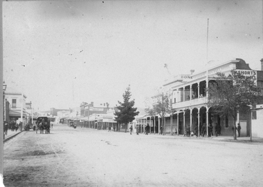
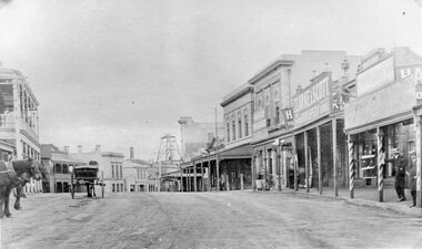 Stawell Historical Society Inc
Photograph, Upper Main Street Stawell looking East with on left the 2 story Allingham building & behind the cart is the Commercial Hotel c1910 -- 2 Photos -- 1 Colour
Upper Main Street Stawell. Looking East c1910. On left two story Allingham building behind cart is Commercial Hotel. Oriental Bank. Punchard Furniture. Crown Cross Poppet head visible on Big Hill. The side of the Mechanics Institute visible near centre. H S Dawson Chemist. Clarke & Scott Drapery on right. Same as 6730-1 & 2785View along upper Main Street looking East towards Big Hill. Poppet Head in distance at centre.stawell streetscape, mining -
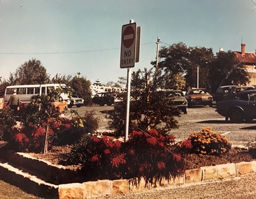 Stawell Historical Society Inc
Photograph, Car Park in Sloane Street looking towards Main Street Stawell c 1978 - Large coloured photograph
Colour photograph of Car Park Sloane Street looking towards Main Street Stawell. The car park was created when Main St. Stawell became a Pedestrian Mall c 1978Large coloured photograph taken from Sloane Street, looking towards Main St. The photo has a bus on the left hand side and cars in the car park. The photo is taken in front of a garden bed with a No Entry sign in the middle of the photograph.stawell -
 Warrnambool and District Historical Society Inc.
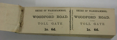
Functional object - Ticket Book, Fairfax & Laurie, Printers, Shire of Warrnambool, Woodford Road Toll Gate, 1s 6d, Circa 1866
In 1866, in an effort to maintain the main roads of the region it was decided to establish toll roads on the Belfast, Woodford, Purnim and Allansford roads. Gates were erected and the leases were disposed of by auction. In 1867 the Woodford tollhouse was destroyed by fire suspected to be deliberate. The tolls were removed three years later after much opposition.This item has historic significant as in the early years(1864) of Warrnambool Tolls were levied on the three main roads leading from Warrnambool into the Shire. In 1864 the Shire of Warrnambool decided that tolls were the only just way to raise funds for maintenance of metalled roads. the Shire of Warrnambool had been created in 1863 from the old Warrnambool Roads Board.Small booklet 140mms long by 40mms wide 13mm depth. Blue & grey marbled cardboard covers back & green oiled cloth binding. Inside full book of double side ticket stubs with perforations in the middle.Shire of Warrnambool. WOODFORD ROAD. TOLL GATE 1s. 6d. Fairfax & Laurie, Printerswarrnambool, shire of warrnambool, woodford road, main belfast road, toll gate, toll tickets, woodford toll house 1866, fairfax & laurie printers -
 Eltham District Historical Society Inc
Photograph - Digital Photograph, Marguerite Marshall, Avenue of Honour, Main Road, Eltham, 20 April 2008
The suggestion of an Avenue of Honour may have been originally put forward by Lady Irvine who was a member of the Welcome Home Committee. The Avenue of Honour was established to memorialise all those from Eltham who enlisted (some of whom were still fighting overseas at the time), similarly as the Shire of Eltham (Soldiers) Memorial Park was in tribute to all from the Shire who enlisted. The twenty-seven names of those killed from Eltham were engraved on the Eltham War Memorial Obelisk unveiled in 1919 at the corner of Main Road and Bridge Street. From an article in the Heidelberg News and Greensborough, Eltham and Diamond Creek Chronicle, September 22, 1917, p. 2, it was reported: Some few weeks ago a public meeting was held in the Eltham Rechabite Hall for the purpose of forming a committee to make necessary arrangements for the return of our brave lads from the front, with the result that the following officers were elected, viz., Sir William Irvine. president; Cr. R. D. Taylor, vice-president; Rev. T. W. Sapsford, secretary; Mr R. E. Gilsenan, treasurer; with a very strong committee of local residents. Lady Irvine then suggested that it would be nice to plant an Avenue of Honor, which was carried out in a very cheerful and spirited manner on Saturday afternoon. Cr Taylor and Mr R. E. Gilsenan occupied themselves during the fore-forenoon in getting the lining-out and other preliminaries ready, but shortly after one o'clock the willing workers could be seen wending their way towards the township, with picks, shovels. &c., on their shoulders, and in a very short time the gang at work was in appearance a very lively and pretty sight, the only thing that was missing was the camera, to have had a few snapshots taken. A little after 3 o'clock Sir William and Lady Irvine, and Mr W. Gray and family, arrived by motor. Cr Taylor then explained that their object in gathering together so hurriedly to plant the avenue was on account of the lateness of the season, and being offered 100 trees, free of charge, by Cr. Wm. G. Gray; of Allwood Nursery, Hurst's Bridge (for which the committee are deeply grateful to him and the public highly appreciate his generous offer). Sir Wm. Irvine then spoke at some length on the ravages of this cruel war, and the good that must result therefrom in bringing all closer together; he also referred to our brave lads who were fighting for us, and thought it was for those at home to show their appreciation by planting the Avenue of Honor. Lady Irvine thou proceeded to plant the first tree, which was an English oak: Sir William following by planting a Spanish chestnut; and Mrs W. G. Gray a sycamore. After that the gathering refired to the entrance of Mr R. E. Gilsenan's green paddock to partake of refreshments, which the ladies had kindly provided for the willing band of workers. Work was again taken to in earnest, and the planting finished, all being satisfied that they had done good work. At the Eltham Shire Council’s monthly meeting held May 6, 1918, Cr. Gray promised to give Council £20 to £25 worth of trees if the Council would plant and guard them. His desire was that a tree be planted in the name of every soldier lad who has gone to the front. Each tree was later adorned with a brass plaque with the name of a soldier and a wooden tree guard placed around them. Over the years many trees died, and following roadworks were replanted on a new alignment. Nillumbik Shire Council is continuing this process of replanting trees in a new alignment to move them away from overhead power lines and to clear the VicRoads reserve. Covered under Heritage Overlay, Nillumbik Planning Scheme. Published: Nillumbik Now and Then / Marguerite Marshall 2008; photographs Alan King with Marguerite Marshall.; p119This collection of almost 130 photos about places and people within the Shire of Nillumbik, an urban and rural municipality in Melbourne's north, contributes to an understanding of the history of the Shire. Published in 2008 immediately prior to the Black Saturday bushfires of February 7, 2009, it documents sites that were impacted, and in some cases destroyed by the fires. It includes photographs taken especially for the publication, creating a unique time capsule representing the Shire in the early 21st century. It remains the most recent comprehenesive publication devoted to the Shire's history connecting local residents to the past. nillumbik now and then (marshall-king) collection, avenue of honour, main road, eltham -
 Marysville & District Historical Society
Photograph (Item) - Black and white photograph, c1940s
An early black and white photograph of the main street in Marysville in Victoria.An early black and white photograph of the main street in Marysville in Victoria. This street is now known as Murchison Street.approx '48 Main Street & shops.murchison street, marysville, victoria -
 Eltham District Historical Society Inc
Photograph, The Rose Stereograph Company, Eltham Road. Greensborough, c.1936
Believed to be looking east along Eltham Road towards Eltham from around the top of the hill near the present day Andrew Yandell Habitat Reserve. Eltham Road, Greensborough followed what is now St Helena Road from Main Road Greensborough running into Karingal Drive and Sherbourne Road finishing at Bridge Street, Eltham. It was renamed sometime between 1968 and 1970. This glass plate negative was used to manufacture postcards (1:1 printing) for commercial sale by the Rose Sterograph Company and its subsidiaries. George Rose founded the Rose Stereograph Company in 1880 and was joined by Herbert (Bert) Cutts in the early 20th Century. The pair formed a lifetime working partnership and strong personal friendship. Assisted by George’s two sons, Herbert George and Walter, and later by Neil Cutts, the Rose Stereograph Company continued its operations for more than 140 years. The company was initially built on stereographs, but as cinema took over and stereographs fell out of fashion, the Rose Stereograph Company developed Australia’s first commercially viable photographic postcard business. Specialising in postcards of iconic historical moments and significant landmarks, The Rose Stereograph Company became a staple of the Australian travel industry.This remarkable collection of glass plate negatives, transparencies, and postcards – arguably Australia’s most significant photography collection outside of public hands – has been passed down through the generations, surviving war, relocation, and the harsh Victorian climate. The historic Rose Stereograph collection is the culmination of George Rose’s dream of capturing and preserving precious moments in time and remains the legacy of the Rose and Cutts families. It is with great sadness that the Cutts family says goodbye to a collection that spans five generations and 140 years. The Cutts family understands that for these historically important pieces to rest with one family is to deny others the pleasure of their custodianship.Glass Plate Negative Size: 9 x 13.9 cmEltham Road, Greensboroughpostcard, travel, rose stereograph company, glass plate negative, greensborough, cutting, eltham road, karingal drive, st helena road, peter and elizabeth pidgeon collection -
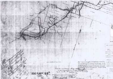 Greensborough Historical Society
Document - Road Plan, Road acquisition, St Helena Road, 1859, 1889
Road plan showing land acquisition for the road to Diamond Creek (NOT Diamond Creek Road), also known as Eltham Road and now known as St Helena Road.Shows the land through which St Helena Road runs, with original owners marked on plan.1 page. Copy of road planroad plans, st helena road greensborough, diamond creek