Showing 10624 items
matching maps
-
 Federation University Historical Collection
Map, Robinson's Ballarat Street Map, c1972, 1970s
A coloured fold-out street map of Ballarat. It also includes a district road map.ballarat, map, ballarat streets -
 City of Moorabbin Historical Society (Operating the Box Cottage Museum)
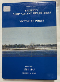
Book, Syme, Marten A, Shipping arrivals and departures, Victorian ports : Volume 1, 1798-1845, 1984
"This book is dedicated to the seamen who supplied the physical link for trade and immigration in the development of the Colony".3 v. : ill., charts, map Maps on lining papers. Includes bibliography and index.non-fiction"This book is dedicated to the seamen who supplied the physical link for trade and immigration in the development of the Colony".ship register, seamen, immigration -
 National Vietnam Veterans Museum (NVVM)
Map
Highly detailed map of Vietnam on parchment from Fwouc Tho Province. Map is waterproof.map, peter lewis -
 Wodonga & District Historical Society Inc
Map - Boorgunyah - "The Town that never was"
At the height of the river trade, there was a town surveyed and laid out, and streets were named. This town was to house the workers at the river port of Red Bank when the paddle steamers plied the Murray River as far as Albury, carrying produce such as wool and wheat to the various towns along the river in the 1800s. As the river trade died away, this town never went ahead – one might say, “The town that never was.” A lone gum tree stands on the site today.This item is significant because it documents plans which were made for the early development of Wodonga.A black an white map depicting the proposed location of the township. The map is based on a sketch and is not to scale,early wodonga, boorgunyah - "the town that never was", wodonga heritage -
Bendigo Historical Society Inc.
Map - SANDHURST GOLDFIELDS MAP, 1873
Topographical map of the Sandhurst Goldfilelds. Surveyed by R Brough. May 1873 Coloured map.bendigo, gold mining, sandhurst goldfields -
Bendigo Historical Society Inc.
Map - NERRING, August 1952
Map: Nerring, County of Bendigo. Parish plan ( number 180 in Map Cupboard 1)map, bendigo, parish plan, nerring, county of bendigo -
Bendigo Historical Society Inc.
Map - HAWKESTONE, 17/11/1915
Map: Hawkestone, County of Talbot. Parish plan ( number 178 in Map Cupboard 1)map, talbot, parish plan, hawkestone, county of talbot -
Bendigo Historical Society Inc.
Map - HARCOURT, September 1951
Map: Harcourt, County of Talbot. Parish plan ( number 177 in Map Cupboard 1)map, talbot, parish plan, harcourt, county of talbot -
Bendigo Historical Society Inc.
Map - KIMBOLTON, No date Visible
Map: Kimbolton, County of Bendigo. Parish plan ( number 172 in Map Cupboard 1)map, bendigo, parish plan, kimbolton -
Bendigo Historical Society Inc.
Map - WHIRRAKEE, 1971
Map: Whirrakee, County of Bendigo. Parish plan ( number 171 in Map Cupboard 1)map, bendigo, parish plan, whirrakee -
Bendigo Historical Society Inc.
Map - EPPALOCK, 15/11/1928
Map: Eppalock, County of Bendigo. Parish plan ( number 170 in Map Cupboard 1)map, bendigo, parish plan, eppalock -
Bendigo Historical Society Inc.
Map - EGERTON, 1/03/1890
Map: Egerton, County of Bendigo. Parish plan ( number 169 in Map Cupboard 1)map, bendigo, parish plan, egerton -
Bendigo Historical Society Inc.
Map - HUNTLY, August 1945
Map: Huntly, County of Bendigo, Parish plan ( number 168 in Map Cupboard 1)map, bendigo, parish plan, huntly, county of bendigo -
Bendigo Historical Society Inc.
Map - BAGSHOT, November 1948
Map: Bagshot, County of Bendigo. Parish plan ( number 167 in Map Cupboard 1)map, bendigo, parish plan, bagshot, county of bendigo -
Bendigo Historical Society Inc.
Map - LYELL, 16/04/1935
Map: Lyell, County of Bendigo. Parish plan ( number 166 in Map Cupboard 1)map, bendigo, parish plan, lyell, county of bendigo -
Bendigo Historical Society Inc.
Map - MARONG, June 1953
Map: Marong, County of Bendigo. Parish plan ( number 164 in Map Cupboard 1)map, bendigo, parish plan, marong, county of bendigo -
Bendigo Historical Society Inc.
Map - DARGILE, November 1953
Map: Dargile, County of Rodney. Parish plan ( number 162 in Map Cupboard 1)map, rodney, parish plan, dargile , county of rodney -
Bendigo Historical Society Inc.
Map - MARONG ALLOTMENTS, 25/08/1906
Map: Plan of Allotments at Marong, Parish of Marong, County of Bendigo. Hand draughted mapmap, bendigo, parish plan, marong, parish of marong -
Bendigo Historical Society Inc.
Map - JANIEMBER WEST, 18/02/1913
Map: Parish of Janiember West, County of Bendigo ( number 140 in Map Cupboard 1)map, bendigo, rural, janiember west , county of bendigo -
Bendigo Historical Society Inc.
Map - CROSBIE, 26/09/1878
Map: Crosbie, County of Rodney. Parish plan (number 260 in map cupboard 1)map, rodney, parish plan, crosbie, county of rodney -
Bendigo Historical Society Inc.
Map - WHIRRAKEE, No date visible
Map: Whirrakee, County of Bendigo. Parish plan (number 258 in map cupboard 1)map, bendigo, parish plan, whirrakee -
Bendigo Historical Society Inc.
Map - ELLESMERE, Circa 1878
Map: Ellesmere, County of Bendigo. Parish plan (number 255 in map cupboard 1)map, bendigo, parish plan, ellesmere -
Bendigo Historical Society Inc.
Map - MUSKERRY, 23/01/1888
Map: Muskerry , County of Rodney. Parish plan. ( number 251 in Map Cupboard 1)map, rodney, parish plan, muskerry -
Bendigo Historical Society Inc.
Map - MUSKERRY, 23/01/1888
Map: Muskerry, County of Bendigo. Parish plan ( number 250 in Map Cupboard 1)map, bendigo, parish plan, muskerry -
Bendigo Historical Society Inc.
Map - NOLAN, 5/03/1888
Map: Nolan, County of Bendigo. Parish plan ( number 249 in Map Cupboard 1)map, bendigo, parish plan, nolan -
Bendigo Historical Society Inc.
Map - MINTO, 10/01/1884
Map: Minto, County of Bendigo. Parish plan. ( number 248 in Map Cupboard 1).map, bendigo, parish plan, minto -
Bendigo Historical Society Inc.
Map - TARNAGULLA, 8/08/1912
Map: Tarnagulla sheet 2. Parish plan ( number 241 in Map Cupboard 1)map, talbot, parish plan, tarnagulla -
Bendigo Historical Society Inc.
Map - GOORNONG, 19/04/1873
Map: Goornong, Hand draughted parish plan ( number 238 in Map Cupboard 1)map, bendigo, parish plan, goornong -
Bendigo Historical Society Inc.
Map - DIGGORRA, 26/04/1880
Map: Diggorra, County of Bendigo. Parish plan ( number 237 in Map Cupboard 1)map, bendigo, parish plan, diggorra -
Bendigo Historical Society Inc.
Map - EGERTON, 13/05/1879
Map: Egerton, County of Bendigo. Parish plan ( number 236 in Map Cupboard 1)map, bendigo, parish plan, egerton