Showing 112690 items
matching tracks/roads
-
 Phillip Island and District Historical Society Inc.
Photograph
Part of collection of Photographs donated to the museum by the family of the late Mr. Jack Jenner (1977)Sepia Postcard - View of bush track, Cowes.Labelled "Lovers Walk, Cowes, Phillip Island".local history, photography, photographs, slides, film, view cowes, sepia photograph, jack jenner, lovers walk cowes, phillip island -
 Halls Gap & Grampians Historical Society
Photograph - B/W
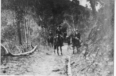
4 men on horseback on bridlel track in the Grampianspeopleaccess routes, bridle path -
 Halls Gap & Grampians Historical Society
Photograph - B/W, C 1960s
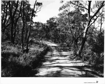
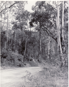
... Roads ...Location unknown.The photo shows a sandy track through bushland.'Forests Commission, Victoria' inscribed on bottom, right of border. 'Publicity & Public relations Branch, When reproducing please Acknowledge Forests Commission, Victoria, Negative No. 322-14' stamped on back.access routes, roads, scenery, grampians ranges -
 Running Rabbits Military Museum operated by the Upwey Belgrave RSL Sub Branch
Butterflies
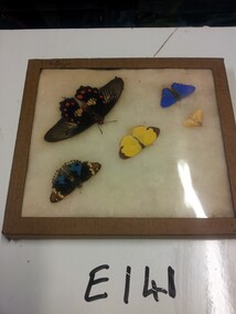
Found on Kokoda Track 3/5/44ephemera -
 Running Rabbits Military Museum operated by the Upwey Belgrave RSL Sub Branch
Butterflies
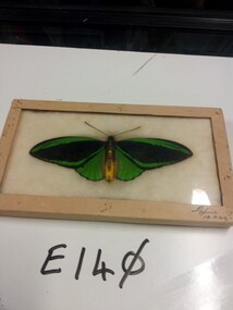
Found on Kokoda Track 12/3/1944ephemera, 1943, general -
National Vietnam Veterans Museum (NVVM)
Film - Film, DVD, In memory of Daryl Fedden: 18th April 1946 - 23rd August 2010
Film, stills and sound track of various singersentertainers - vietnam war -
 Bendigo Historical Society Inc.
Slide - BENDIGO TRAIN IN TOWN, Feb 1970
Slide. Bendigo Train in Town. Laying the track.slide, bendigo, bendigo train in town., bendigo train in town. laying the track. -
 Whitehorse Historical Society Inc.
Photograph, Mitcham Scene
Black and white photo of bush track Mitchammitcham, bush track -
 Sunbury Family History and Heritage Society Inc.
Photograph, 17th December 1985
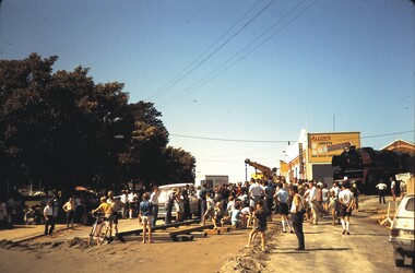
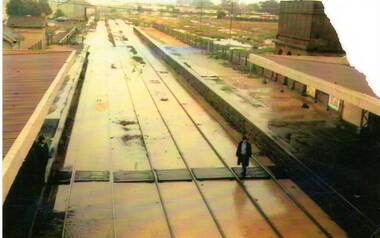
On the afternoon of the 17th December 1985 torrential rain fell in Sunbury and surrounding areas which resulted in widespread flooding and caused disruption on the main Melbourne Bendigo Railway line. The photograph looking towards the south shows the extent of the flooding at Sunbury Station.A coloured photograph of a railway station and the flooded tracks.sunbury railway station -
 Vision Australia
Photograph - Image, Historical footrace
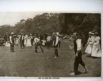
An image from a footrace that was held for blind individuals, using ropes as guide lines. Competitors held cloths to prevent their hands from the friction as they navigated the course without canes or a guide. Copy of a sepia toned photograph of footrace trackroyal blind society of nsw, recreation -
 8th/13th Victorian Mounted Rifles Regimental Collection
Manual
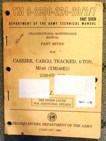
Tracked cargo carrier is part of M113 family of armoured vehicles used by 8/13 VMR in 1970s and 1990s. Technical manuals and User Handbooks were essential equipment for Royal Australian Electrical and Mechanical Engineers (RAEME) tradesmen permanently attached to Armoured Corps regiments as Light Aid Detachments (LAD) or Tech Support Troop (TST) and were responsible for repairs and maintenance of a nature beyond the expertise of AFV crewmen and just short of major rebuilds undertaken by Base Workshop detachments.Part of a collection of workshop manuals and user handbooks relating to equipment on issue to 8th/13th Victorian Mounted Rifles during the latter half of the twentieth century.Buff coloured soft covered manual bound with heavy metal staples, 353 pages being Organisational Maintenance Manual Part Seven for Carrier Cargo Tracked 6 Ton M 548.Published by Headquarters Department of the Army ( USA ) February 1966.Ink stamp on title page " 8/13 VMR Regimental collection " and ink notation on cover " Obsolete " and ink on spine " 21 " -
 Federation University Art Collection
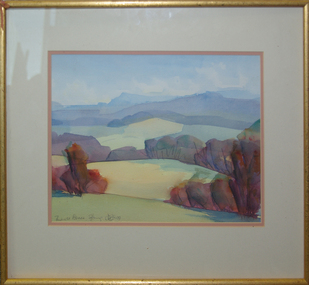
Painting - Watercolour, 'Towards Avoca' / 'Mount Buninyong in Autumn' by David Alexander, 1999
This item is part of the Federation University Art Collection. The Art Collection features over 1000 works and was listed as a 'Ballarat Treasure' in 2007.Unframed double sided landscape artwork by David Alexander. One side is 'Towards Avoca' and the other side is 'Buninyong From Main Road, 24/04/1999'David Alexander wrote on 'Buninyong From Main Road, 24/04/1999' "Wash wouldn't dry. People everywhere"art, artwork, david alexander, alexander, buninyong, avoca, watercolour -
 Wodonga & District Historical Society Inc
Photograph - Carkeek's Terminus Family Hotel, Wodonga, c1890
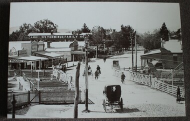
The Terminus Hotel, Wodonga was built by James Thompson Hatch in 1873, the same year the railway reached Wodonga from Melbourne. It was named due to its close proximity to the railway terminus. It was sold to Messrs George Day and Kenneth McLennan of Albury. It was first licenced to J.G. Morton in January 1874. Annie Allen, from Ireland, took over as licensee of the hotel containing 14 rooms in 1879, after she and her husband, George James Allen, purchased it. In 1887 they added a new wing on the south boundary of the property next to Peter McLean’s store at 81 Sydney Road. The architects for the new wing were Gordon and Gordon. A billiard room, a dining room, and 18 other rooms were added on the vacant block of land between the Hotel and the Bank of Victoria. A balcony 6 feet wide was added on the north side. Included in the plans was the latest patent elevator, later known as a dumb waiter. Allen died in 1889 aged 52, and Annie Allen continued to run the Terminus. She later married John G. Haldon and was licensee of the hotel until December 1898 when the licence was transferred to William Carkeek. Carkeek, from Cornwall, arrived in the colony around 1860 and is considered one of the founders of Tallangatta. In November 1903, the license was transferred to Daniel Crawford, then in 1906 it was transferred to Mr Stephen Carkeek. In 1916 it passed into the hands of Mr H. W. Allen of Rutherglen, son of Mr George James Allen. On 1st June 1998 the Terminus Hotel was destroyed by fire. Estimates of damage range from between a conservative $750,000 to as high as $2 million. The remains of the building were demolished in 1999.The Terminus Hotel was one of the earliest hotels in Wodonga with clear links to the establishment of the railway line. It was an important business and meeting place for social gatherings.A black and white image printed on canvas. The image includes Carkeek's Terminus Family Hotel in Sydney Road, now named High Street, Wodonga, Victoria. Other businesses shown include a produce store, D.M. Staveley Taylor, John Whan General Store. The railway track can be seen in the foregrounc.Across side of building "CARKEEK'S TERMINUS FAMILY HOTEL" On bottom left "High Street Wodonga 1890s"carkeek, terminus hotel, hotels wodonga -
 Halls Gap & Grampians Historical Society
Photograph - B/W, C 1960
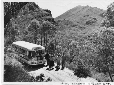
... Roads ...The name of the road Henham Gap was later changed to MirranatwaPhoto shows bus and tourists on road looking over Henham Gap, Bus company - BoyVictorian Railways Photographaccess routes, roads, henham gap -
Whitehorse Historical Society Inc.
Document, Tunstall Town Estate, 1/03/1926 12:00:00 AM
Auction brochure of Tunstall Town Estate.Auction brochure of Tunstall Town Estate, cnr Whitehorse and Springvale Roads, Tunstall by Coghill & Haughton.Auction brochure of Tunstall Town Estate. kelly, john james, tunstall town estate, whitehorse road, tunstall, springfield road, tunstall, coghill & haughton, glendale street, nunawading, silver grove, nunawading, railway parade, nunawading -
![Map, [Plan for road to give J. Allan access to permanent water at Coimadai] circa 1870s](/media/collectors/5e461d8021ea67224c82f2a1/items/67735190d671e67dd573a84c/item-media/6773533dd671e67dd573cd90/item-fit-380x285.jpg) Bacchus Marsh & District Historical Society
Bacchus Marsh & District Historical SocietyMap, [Plan for road to give J. Allan access to permanent water at Coimadai] circa 1870s
The date of this map or plan is uncertain but it appears to be from the early to mid 1870s. One of the landholders identified on the plan, James Allan of Coimadai died suddenly on the 9th July, 1874 (see Bacchus Marsh Express, 11 July, 1874, page. 3). There are mentions of an Allans Road at Coimadai in the Bacchus Marsh Express between 1887 and 1942.Single page map showing an excision of land belonging to Charles Ross which was selected to construct a road to give another landholder, J. Allan access to permanent water. Scale 1 chain to 1 inch. Part of a set of maps which are pasted into a bound volume containing 76 maps or plans in total. High resolution digital image stored on BMDHS computer network. Plan showing Excisions from Ross's selection and 1 chain road thro' the said selection in Coimadai to give J. Allan access to permanent water. Alistair ?? Shire Eng? 6?/5/7?coimadai victoria maps, coimadai roads and streets -
 Camberwell Historical Society
Postcard - Photo postcard, 1989
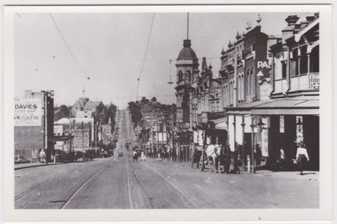
Glossy black and white photograph with white border on a postcard, depicting Burke Road dating around 1923. Photograph shows people crossing tram line surrounded by buildings, with horse and cart in the foreground.Back of postcard: Burke Road, Camberwell, c. 1923. La Trobe Collection, State Library of Victoria. -
 City of Moorabbin Historical Society (Operating the Box Cottage Museum)
Photograph, Black & White, Mr Moore's 1st Chemist Shop Centre Road, Bentleigh c1930, c1930
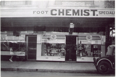
Early settlers in the Parish of Moorabbin, County of Bourke, established market gardens and farms in the area of Henry Dendy's Special Survey 1841 Brighton. Small communities grew near Churches & Schools and shops and businesses were established. Following the opening of the Railway line from Caulfield to Mordialloc 1881 the shops and business moved from the Tucker Road /Centre Road ( East Brighton ) East Bentleigh area to be close to the transport. Shops, businesses and housing developed along Centre Road between Thomas Street and Jasper Road. Mr Arthur Moore established his 1st shop in 395 Centre Road c1930 and later moved along the road to a site next to Coles Variety Store.Following the opening of the Railway line from Caulfield to Mordialloc 1881 the shops and business moved from the Tucker Road /Centre Road East Bentleigh area to be close to the transport. Shops, businesses and housing developed along Centre Road between Thomas Street and Jasper Road. Mr Moore established his 1st shop in 395 Centre Road c1930 and later moved along the road to a site next to Coles Variety Store.Black & White photograph of Mr Arthur Moore's 1st Chemist Shop, 384 Centre Road Bentleigh c 1930 back Handwritten information unsignedbentleigh shopping centre c1930, east brighton, railway line caulfield -mordialloc 1881, chemists, pharmacy, moore's moorabbin shire, smith j l, smith mary ann, stanley helen, smith vic, smith harry redvers, chaff cutter, horse drawn carts, toll gates brighton, motor cars 1900, steam engines, early settlers, bentleigh, mckinnon, parish of moorabbin, city of moorabbin, county of bourke, moorabbin roads board, shire of moorabbin, henry dendy's special survey 1841, were j.b., bent thomas, o'shannassy john, king richard, charman stephen, highett william, ormond francis, maynard dennis, market gardeners, vineyards, orchards -
 Vision Australia
Photograph - Image, Royal Victorian Institute for the Blind view from front lawn
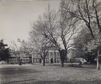
View of RVIB building in St Kilda Road, taken from the front lawn. Leaves are scattered across the grass and a single male figure stands outside the building.1 black and white photograph of St Kilda Road buildingroyal victorian institute for the blind, buildings -
Whitehorse Historical Society Inc.
Article, Winlaton Youth Training Centre, 2008?
History of Winlaton Youth Training Centre for female offenders.History of Winlaton Youth Training Centre for female offenders, which was located at 186 Springvale Road NunawadingHistory of Winlaton Youth Training Centre for female offenders.springvale road nunawading, no. 186, winlaton youth training centre -
 Broadmeadows Historical Society & Museum
Photograph - Fatal Accident, Leader newspaper, 16 September 1986
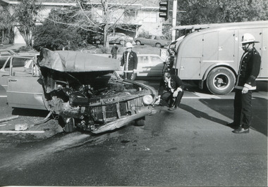
Fatal accident Somerton Road and Hume Highway 1986Event in SomertonPhoto b/w: 17.5 cm x 12 cmObs 17//9/86; P1; Pascoe Vale Road crash Leader Newspaper stampfatal accident, hume highway, somerton road, somerton, broadmeadows observer -
 Halls Gap & Grampians Historical Society
Photograph - Sepia, C 1900s
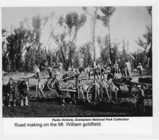
... Roads ...Photo depicts "road-making" approaching the Mount William gold fields. Because of the heavy traffic in the area during the very wet winter of 1900, low sections of the track became quagmires and road building was essential.Photo shows men with horses, carts, shovels etc. There are six horses in photo, three of them hitched up to carts. There are twenty-two men in total, some holding shovels etc.Photo has been laminated. "Title" appears at bottom of photo together with previous holder of photoaccess routes, roads, access routes, road building -
 Halls Gap & Grampians Historical Society
Photograph - Photocopy, C 1936
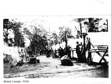
The relief workers as shown in the photograph were used in the Grampians for logging & road maintenance. After the Depression many hundreds of men worked on building and maintaining roads &: tracks. Some were employed by the Forest Commission of Victoria.people, road gang, structures, tents -
 Melbourne Tram Museum
Poster, Tram Service Changes, March 2022
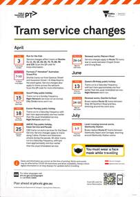
Poster advising passengers in trams of the planned service changes for April, June and July 2022. Includes the Grand Prix, public holidays, Malvern Road, Glenferrie Road track renewals and Glenhuntly level crossing removal.Demonstrates the methods that Yarra Trams use to advise passengers of service changes.A3 size colour poster regarding tram service changes. Two plastic covers that contain the posters in the rack included in the A3 folder.posters, tramways, trackwork, passengers, tramcars, glenhuntly station, grand prix -
 Melbourne Tram Museum
Slide - Black and white reproduction photograph - PMTT tram 4 Glenferrie Road 1910
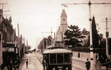
Photograph - PMTT tram 4 Glenferrie Road 1910, possibly undertaking testing prior to the official opening on 30/5/1910. Photo shows the centre of the road overhead support poles in Glenferrie Road and a "Hail Cars Here" sign. In the background is the Malvern Town Hall, signs for Norwich Union and Walter Wright Hairdresser.Yields information about the opening of the tram lines built by the PMTTKodachrome cardboard duplicate slide - Black and white reproduction photograph - PMTT tram 4 Glenferrie Road 1910 "MP5" in penciltrams, tramways, opening, tram 4, pmtt, glenferrie road, tram stop -
 Kew Historical Society Inc
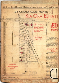
Plan - Subdivision Plan, Kia Ora Estate, 1930s
Twenty-five grand allotments were offered for sale in the subdivision known as the Kia Ora Estate in Balwyn in the early 1930s. The streets identified in the subdivision include Whitehorse Road, Barnsbury Road, Campbell Road, Mont Albert Road and Burke Road. The lots were advertised for £10 deposit, with the balance to be paid over 5 years at 5 per cent per annum. The lots bordering Whitehorse Road were nominated as potential valuable shop sites, while the Mont Albert Road lots were advertised as having ‘wonderful views’. The Outer Circle Railway Line is shown traversing the subdivision. The route of the Railway in this area is now a walking/bike track bordered by strips of parkland.subdivision plans - balwyn, kia ora estate -
 Surrey Hills Historical Society Collection
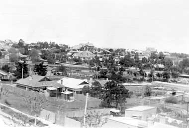
Photograph, Surrey Hills looking south-east from the steeple of Holy Trinity Church, 1921, 1921
The property in the foreground is 'Edgeware' at 171 Union Road, a house built by the Zeplin family. It became the home / residence of Dr Percy Liddle and later Dr James Landells Blakie. By the time this photo was taken Dr Blakie had moved across the road to 174 Union Road. In the background behind the 2 houses in the foreground is the Surrey Hills Stationmaster's house, sitting behind a picket fence. The Alan Holt register gives a build date of c1915 for this house, which fits stylistically. The first stationmaster was probably Michael Ginnane, who stayed in the area after he retired, moving to 1 Russell Street. This property was listed as 8 Bedford Avenue, the only house on the south side of the road. It was demolished in c1972 to make way for widening of the rail track with a third line. The photographer Norman Carter took many photos of Surrey Hills and Mont Albert from the 1920s, in particular of events and activities associated with the Church of England.Black and white photo taken from the steeple of Holy Trinity Church looking across housing towards the railway line and Albany / Windsor Crescents and on towards Canterbury Road. Surrey Hills Primary School and St Stephens Presbyterian Church feature prominently on the horizon. The stationmaster's cottage is centre left adjacent to a large conifer-like tree, with a white fence delineating the railway yards.On back of original: "6-11-21" and in a different hand in biro: "from tower of Holy Trinity Church"albany crescent, windsor crescent, st stephens presbyterian church, surrey hills primary school, railways, stationmasters' houses, bedford avenue, norman carter, edgeware, dr percy liddle, dr james blakie -
 Ringwood and District Historical Society
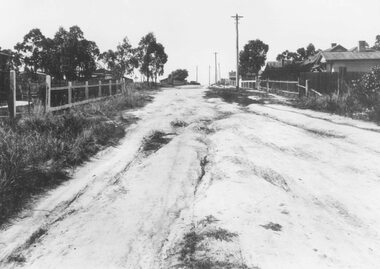
Photograph, Barkly Street, Ringwood - c1948
Black and white photograph of unmade road in poor condition. Houses in background.Typed below photograph, "Barkly St., Ringwood c.1948". Catalogue card states, "Taken about 100 yards down from Wantirna Road. Car probably going south along Wantirna Road. House far right now block of flats (Sept. 1975) but next two houses up street are there. Haig St. just behind car. Fence on house to left still there and curved front path. Shop visible corner Haig St. to left of big pole still there." -
Whitehorse Historical Society Inc.
Article, Traders Trapped, 1985
Eight Businesses at Houston Shopping Centre, Middleborough Road, Box Hill.Eight Businesses at Houston Shopping Centre, Middleborough Road, Box Hill, facing rezoning of land reserved for the Healesville Freeway. Traders say they are being treated unfairly by the Road Construction Authority, owner of the land.Eight Businesses at Houston Shopping Centre, Middleborough Road, Box Hill. land use, anderson camp -
 Marysville & District Historical Society
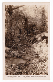
Postcard (item) - Black and white postcard, Rose Stereograph Company, The Wolfram Track, Marysville, Victoria, 1913-1967
A postcard in a series produced by the Rose Stereograph Company in Victoria, Australia as a souvenir of Marysville.A black and white photograph of the Wolfram Track which is part of the Wilks Creek Walking Track near Marysville in Victoria. The Wolfram Track is named after the Wilks Creek Wolfram Mine which opened in around 1894. Wolframite is one of the principle ores of tungsten. The discovery was made in Wolfram Creek by a Mr Robinson who was probably a local of the district. Four creeks eventually proved to carry alluvial deposits of the ore; Wolfram Creek, Opas Creek, Quartz Creek and Main Creek. These creeks run south-east into Deep Creek, a tributary of the O'Shannassy River which, in turn, runs into the Yarra River.POST CARD The "Rose" Series/ De Luxe A Real Photograph/ Produced in Australia Published by the Rose Stereograph Co.,/ Sydney and Melbourne.wolfram track, wilks creek walking track, marysville, victoria, p. 2332, walking track, rose series postcard, postcard, souvenir, wolframite, wolfram creek, opas creek, quartz creek, main creek, deep creek, o'shannassy river, yarra river, mining