Showing 22371 items matching "will park"
-
 Lakes Entrance Historical Society
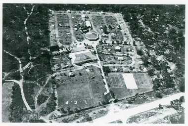
Photograph - Whiter's Camp Park, Bulmer H D, 1935
Black and white aerial view of Whiters Camp Park, looking north from Roadknight Street, showing layout of park including tennis courts, bowling green, picnic area, cottages, rotunda, and the family residence. Lakes Entrance Victoria tourism, camping -
 Charlton Golden Grains Museum Inc
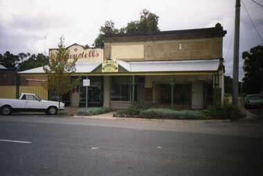
Photograph, Brownjohn, Reg, Charlton High Street 1988, c.1988
Charlton High Street centre 1988. Vic Arundell's Shoe Shop, Stock & Station Agent and former W. Williams Saddlery (later Bullock's Grocery). Buildings latr demolished to become the Traveller's Rest. Williams St renamed John Curtin Drive.Colour photograph of Vic Arundell's shop and former W. Williams Saddlery on the corner of High St and Williams St. For Sale sign over the middle building. White ute parked in front of Arundell's. Another ute parked at side of buildings.bullocks grocery, business, industry, high street, arundell, shoe shop, saddlery, w. williams -
 Kew Historical Society Inc
Plan, Melbourne & Metropolitan Board of Works : Borough of Kew : Detail Plan No.1350, 1910
The Melbourne and Metropolitan Board of Works (MMBW) plans were produced from the 1890s to the 1950s. They were crucial to the design and development of Melbourne's sewerage and drainage system. The plans, at a scale of 40 feet to 1 inch (1:480), provide a detailed historical record of Melbourne streetscapes and environmental features. Each plan covers one or two street blocks (roughly six streets), showing details of buildings, including garden layouts and ownership boundaries, and features such as laneways, drains, bridges, parks, municipal boundaries and other prominent landmarks as they existed at the time each plan was produced. (Source: State Library of Victoria). This plan forms part of a large group of MMBW plans and maps that was donated to the Society by the Mr Poulter, City Engineer of the City of Kew in 1989. Within this collection, thirty-five hand-coloured plans, backed with linen, are of statewide significance as they include annotations that provide details of construction materials used in buildings in the first decade of the 20th century as well as additional information about land ownership and usage. The copies in the Public Record Office Victoria and the State Library of Victoria are monochrome versions which do not denote building materials so that the maps in this collection are invaluable and unique tools for researchers and heritage consultants. A number of the plans are not held in the collection of the State Library of Victoria so they have the additional attribute of rarity.Original survey plan, issued by the MMBW to a contractor with responsibility for constructing sewers in the area identified on the plan within the Borough of Kew. The plan was at some stage hand-coloured, possibly by the contractor, but more likely by officers working in the Engineering Department of the Borough and later Town, then City of Kew. The hand-coloured sections of buildings on the plan were used to denote masonry or brick constructions (pink), weatherboard constructions (yellow), and public buildings (grey). MMBW Plan No. 1350 depicts the western end of Studley Park on the north side of the Studley Park Road. ‘Raheen’, then the home of Sir Henry Wrixon is named, the plan identifying those parts of the house that were built of brick and timber. The two houses between Raheen and the River Yarra are also shown. Other parts of the plan show neighbouring streets: Yarra Street, Studley Park Avenue, Studley Street and Fenwick Street. Each, apart from Fenwick Street was subsequently renamed. At the corner of Fenwick and Stawell Streets, the home of Joseph Butterworth Coombs, later called ‘Hope Mansell’, is represented but unnamed.melbourne and metropolitan board of works, detail plans, mmbw 1350, cartography -
 Federation University Historical Collection
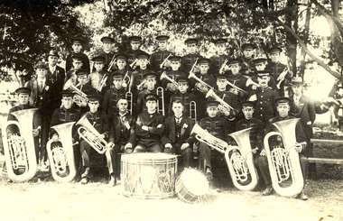
Photograph - black and white, City of Ballarat Band, 1923?
Frank Wright was a renown resident of Smeaton, where he was born on 2 August 1901. He lived at Laura Villa, and attended Smeaton State School. His father William was a gold miner and his mother's name was Sarah. Their family won many singing and instrumental awards. Frank was tutored by Percy Code and was awarded a gold medal for the highest marks in the ALCM examinations in the British Colonies at the age of seventeen years. He became the Australian Open Cornet Champion by the age of eighteen. A year later, Frank conducted the City of Ballarat Band, and later the Ballarat Soldiers’ Memorial Band. He formed the Frank Wright Frisco Band and Frank Wright and his Coliseum Orchestra. These bands won many South Street awards, and Frank as conductor won many awards in the Australian Band Championship contest. In 1933 Frank Wright sailed to England to conduct the famous St Hilda’s Band and was later appointed Musical Director of the London County Council, where he organized many amazing concerts in parks, in and around the London district. He was made Professor of Brass and Military Band Scoring and conducted at the Guildhall of Music and Drama. Frank was often invited to adjudicate Brass Band Championships around Europe, in Australia, including South Street and in New Zealand. The Frank Wright Medal at the Royal South Street competition is awarded to an individual recognized as making an outstanding contribution to brass music in Australia.Black and white photograph of the members of a brass band with their instruments and some gentlemen in suits. They are situated in a park with trees as the backdrop. In the lower centre front position is Frank Wright. The band is the City of Ballarat Band.frank wright, conductor, brass band, city of ballarat band -
 Bendigo Historical Society Inc.
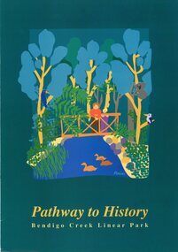
Pamphlet - MERLE HALL COLLECTION: ROSALIND PARK CREATIVE VILLAGE BENDIGO PROJECT PAMPHLET, 1993
MERLE HALL COLLECTION: ROSALIND PARK CREATIVE VILLAGE BENDIGO PROJECT PAMPHLET Pathway to History Bendigo Creek Linear Park Inside pages - Graphic image of the Linear Park from Alexandra Fountain to the Botanical Gardens, includes Rosalind Park, Golden Dragon Museum, Shamrock Hotel, Bendigo Gas Works, Chinese Joss House, Chinese Tea House, Lake Weroona, Wetlands, White Hill Cemetary and mine sites. On outside pages, cover, historical notes on Bendigo and Notes on the Bendigo Creek Linear Park. Notes on the back cover: A joint project of the City of Greater Bendigo and the Department of planning and development. Production by the Publick Affairs Branch, Department of Planning and Development. Printed in Bendigo June 1993 4360/93. -
 Kew Historical Society Inc
Plan, Sydney Arnold Best & Co, Field Place, Kew, c.1929
Pru Sanderson, in her groundbreaking ‘City of Kew Urban Conservation Study : Volume 2 - Development History’ (1988), summarised the periods of urban development and subdivisions of land in Kew. The periods that she identified included 1845-1880, 1880-1893, 1893-1921, 1921-1933, 1933-1943, and Post-War Development. These periods were selected as they represented periods of rapid growth or decline in urban development. An obvious starting point for Sanderson’s groupings involved population growth and the associated economic cycles. These cycles also highlighted urban expansion onto land that was predominantly rural, although in other cases it represented the decline and breakup of large estates. A number of the plans in the Kew Historical Society’s collection can also be found in other collections, such as those of the State Library of Victoria and the Boroondara Library Service. A number are however unique to the collection.The Kew Historical Society collection includes almost 100 subdivision plans pertaining to suburbs of the City of Melbourne. Most of these are of Kew, Kew East or Studley Park, although a smaller number are plans of Camberwell, Deepdene, Balwyn and Hawthorn. It is believed that the majority of the plans were gifted to the Society by persons connected with the real estate firm - J. R. Mathers and McMillan, 136 Cotham Road, Kew. The Plans in the collection are rarely in pristine form, being working plans on which the agent would write notes and record lots sold and the prices of these. The subdivision plans are historically significant examples of the growth of urban Melbourne from the beginning of the 20th Century up until the 1980s. A number of the plans are double-sided and often include a photograph on the reverse. A number of the latter are by noted photographers such as J.E. Barnes.An unnamed subdivision in Studley Park including five lots for sale in Studley Park Road, Highfield Grove and Tara Avenue. Unidentified on the plan, but clearly existing, are the Henty family mansion of Field Place and Tara Hall in Studley Park Road. The first attempted subdivision of Tara Hall was advertised in 1927 in which Lots 5, 6 and 7 in this plan were also advertised. Unusually, Lot 2 in Studley Park Road was created from the northern part of the Henty mansion, rather than Tara Hall. In the subdivision, lots were advertised at varying prices, with the highest price for land being Lot 2 in Studley Park Road. The plan notes that only one villa is to be allowed on each allotment.subdivision plans - kew, field place subdivision -- studley park – kew (vic.), highfield grove – kew (vic.), tara avenue – kew (vic.) -
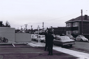
 Ringwood and District Historical Society
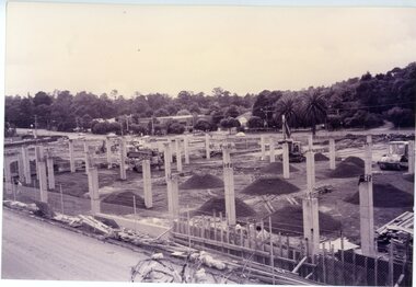
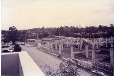
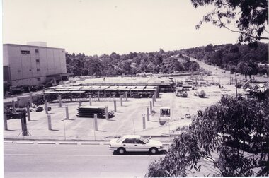
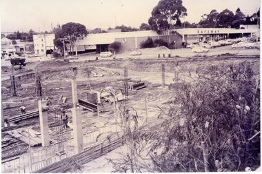
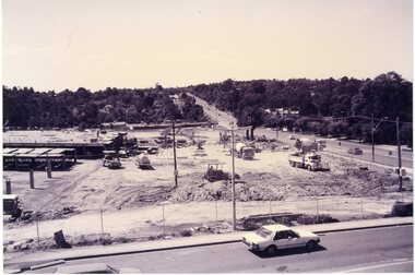
Photograph, Eastland car park construction -1992
Sepia postcard size photograph"Written on back of photograph" Eastland - Stage 2 Foundations for new car park -24.11.92 -
 Ringwood and District Historical Society
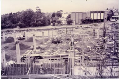
Photograph, Eastland car park construction -1992
Sepia postcard size photograph"Written on back of photograph" Eastland - Stage 2 Foundations for new car park -24.11.92 -
 Ringwood and District Historical Society
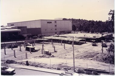
Photograph, Eastland car park construction -1992
Sepia postcard size photograph"Written on back of photograph" Eastland - Stage 2 Foundations for new car park -24.11.92 -
 Ringwood and District Historical Society
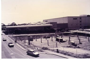
Photograph, Eastland car park construction -1992
Sepia postcard size photograph"Written on back of photograph" Eastland - Stage 2 Foundations for new car park -24.11.92 -
 Ringwood and District Historical Society
Photograph, Eastland car park construction -1992
Sepia postcard size photograph"Written on back of photograph" Eastland - Stage 2 Foundations for new car park -24.11.92 -
 Ringwood and District Historical Society
Photograph, Eastland car park construction -1992
Sepia postcard size photograph"Written on back of photograph" Eastland - Stage 2 Foundations for new car park -24.11.92 -
 Ringwood and District Historical Society
Photograph, Eastland car park construction -1992
Sepia postcard size photograph"Written on back of photograph" Eastland - Stage 2 Foundations for new car park -24.11.92 -
 Ringwood and District Historical Society
Photograph, Eastland car park construction -1992
Sepia postcard size photograph"Written on back of photograph" Eastland - Stage 2 Foundations for new car park -24.11.92 -
 Greensborough Historical Society
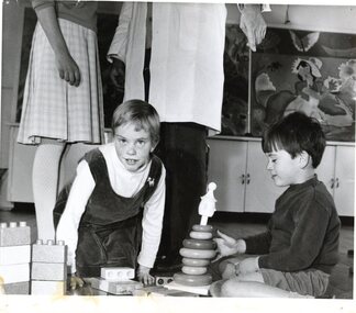
Photograph, Mental Health Department, Children at play, Janefield 1968, 1968
Photograph of two children playing on floor at Janefield 1968Black and white photographStamped on back: "Mental Health Dept., Negative Ref: M25K, Mont Park 1968"janefield, janefield special school -
 Greensborough Historical Society
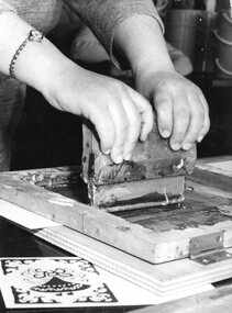
Photograph, Mental Health Department, Printmaking demonstration, Janefield 1968, 1968
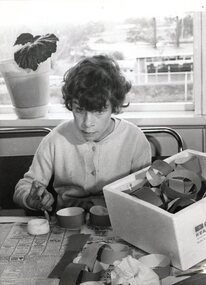
Close up photograph of a printmaking demonstration at Janefield 1968Black and white photographStamped on back: "Mental Health Dept., Negative Ref: M25A, Mont Park 1968"janefield, janefield special school, printmaking -
 Greensborough Historical Society
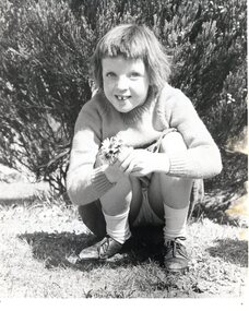
Photograph, Mental Health Department, Girl with daisies, Janefield 1968, 1968
Photograph of a Janefield student with a bunch of daisies 1968Black and white photographStamped on back: "Mental Health Dept., Negative Ref: M25G, Mont Park 1968"janefield, janefield special school -
 Greensborough Historical Society
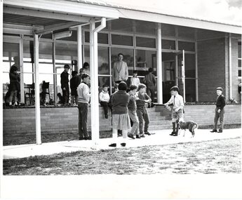
Photograph, Mental Health Department, Boys playing outside, Janefield 1968, 1968
Photograph of a group of Janefield students playing and observing others 1968Black and white photographStamped on back: "Mental Health Dept., Negative Ref: M16, Mont Park 1968"janefield, janefield special school -
 Greensborough Historical Society
Photograph, Mental Health Department, Girl making paper chains, Janefield 1968, 1968
Photograph of a Janefield student making paper chains 1968Black and white photographStamped on back: "Mental Health Dept., Negative Ref: M25B, Mont Park 1968"janefield, janefield special school -
 Greensborough Historical Society
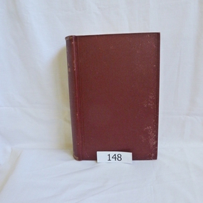
Book, Angus & Robertson Ltd, Official History of Australia in the War of 1914-18; by C. E. W. Bean. 8th edition, 1938_
The official history of Australia in WW1 written by C. E. W. Bean12 volumes. Hard cover, dark red binding. Maps and black and white illustrationsPresented to James Gordon Saunders Longfellow St Norman Park Q July 1950c e w bean, world war i, australia army, gallipoli -
 Greensborough Historical Society
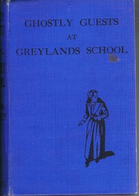
Book, Norma Bradley, Ghostly guests at Greylands by Norma Bradley, 1950s
Schoolgirl's novel of the 1950sHardback, 221 p., illus."Shirley M. Black, "Hillboro' Park", Grimshaw Street, Bundoora. From: Mum 20.4.1954.shirley black -
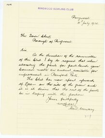
 Ringwood and District Historical Society
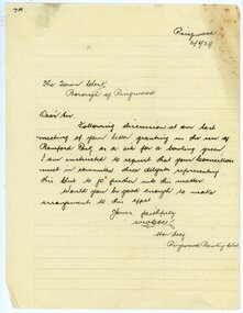
Letter, Ringwood Bowling Club requesting to meet councillors regarding the use of Bamford Park in 1929
1929 saw the establishment of the Ringwood Bowls Club initially located on the land now occupied by the Eastland Shopping Centre. It moved to its current location in Loughnan Road, Ringwood in 1997.Ringwood Bowling Club requesting to meet councillors regarding the use of Bamford Park in 1929city of ringwood bowls club, ringwood bowling club, ringwood bowls club, lawn bowls, bowling -
 Ringwood and District Historical Society
Letter, Ringwood Bowling Club asking the council for a grant for improvements to Bamford Park in 1930
1929 saw the establishment of the Ringwood Bowls Club initially located on the land now occupied by the Eastland Shopping Centre. It moved to its current location in Loughnan Road, Ringwood in 1997.Ringwood Bowling Club asking the council for a grant for improvements to Bamford Park in July 1930.city of ringwood bowls club, ringwood bowling club, ringwood bowls club, lawn bowls, bowling -
 City of Moorabbin Historical Society (Operating the Box Cottage Museum)
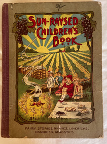
Book, DeGaris, C. J. (Clement John), Sun-Raysed Children's Book : Fairy Stories, Rhymes, Limericks, Parodies, Acrostics, 1919
Contains prize-winning fairy stories, rhymes, limericks, etc. from entries in the Sun-raysed competitions of January, 1919.52 p. : ill. (some col.) ;fictionContains prize-winning fairy stories, rhymes, limericks, etc. from entries in the Sun-raysed competitions of January, 1919.fairy tales, dried fruit, children's literature -
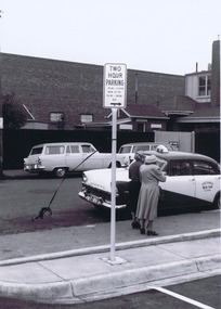 St Kilda Historical Society
Photograph, Camden Street carpark, Balaclava, 11/1962
Opening of carpark Camden Street Balaclava black and white photograph, unmounted, original, good conditionOn back: Car Park opening Camden Street Nov 1962 From Leete Chemist -
 St Kilda Historical Society
Photograph, Camden Street carpark, Balaclava, 11/1962
Opening of carpark Camden Street Balaclava black and white photograph, unmounted, original, good conditionOn back: Car Park opening Camden Street Nov 1962 From Leete Chemist -
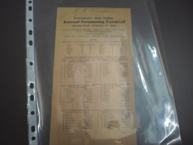 Wangaratta High School
WHS Swimming Carnival Pamphlet, 1954
Yellow Wangaratta High School Annual Swimming carnival pamphlet WANGARATTA HIGH SCHOOL Annual Swimming Carnival Merriwa Park- February 18 1954 -
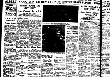 Power House Rowing Club
Newspaper clipping, ALBERT PARK WIN GILBEY CUP, 1937
SENIOR FOURS TO UNIVERSITY Lose Contests in V.R.A. Maiden 8's To Albert Park -
![Photograph (sub-item) - Black and White, The Wonga Park ‘swimming pool’ in the Yarra River, 1940’s – now in Jumping Creek Reserve (1985) [This may be the swimming pool in Jumping Creek Reserve or may be the swimming pool in Clifford Park in use in the 1948-9 Pan-Pacific Jamboree]](/media/collectors/5c7716e021ea6a1a60039fee/items/631b95b3d61f455ba20ef2cb/item-media/631b961fd61f455ba20ef417/item-fit-380x285.jpg) Wonga Park Community Cottage History Group
Wonga Park Community Cottage History GroupPhotograph (sub-item) - Black and White, The Wonga Park ‘swimming pool’ in the Yarra River, 1940’s – now in Jumping Creek Reserve (1985) [This may be the swimming pool in Jumping Creek Reserve or may be the swimming pool in Clifford Park in use in the 1948-9 Pan-Pacific Jamboree]
THE ROSE SERIES P. 922 SWIMMING POOL, RIVER YARRA, WONGA PARK, VIC. -
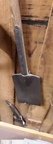 Mont De Lancey
Tool - Spade, Parkes & Co, Unknown
Used by Wandin Sebire for an unknown purpose.An unusual split headed long thin spade with a wooden handle Four rivets attach the head to the handle. At the top the handle is screwed to the metal. It was used by Wandin Sebire, probably for a special purpose - it is not known for what. Spades are usually used for turning soil by pushing against the blade with the foot. Used in the early 20th century.Stamped on the metal handle - '2' and 'S & C Ham'. 'Parkes & Co. Birmingham no. 2'.gardening spades, spades, shovels, gardening tools