Showing 110313 items matching "roads"
-
 Bialik College
Scrapbooks, Student work
Scrapbooks of student work, including 'The Beginning', 'Land Reclamation', 'Planting Trees', 'Good Farming', 'Planning and Roads', c. 1980s and a booklet of poetry, 1984. Please contact [email protected] to request access to this record.student work, poetry, 1980s -
 Mt Dandenong & District Historical Society Inc.
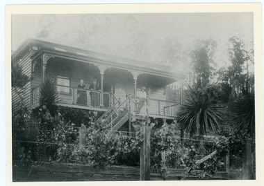
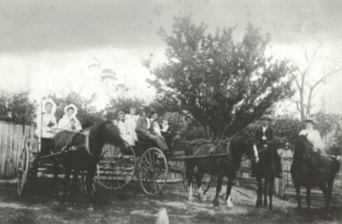
Photograph, Home of George and Sarah Barber c1905
George and Sarah Ann Barbers home "Forest Edge' on Barber's Road. Jabez Richardson (father of Sarah Ann) and his wife Sarah jane are standing on the front verandah. An unknown male is also in the picture.Black and white photograph showing four adults standing on the front verandah of a house. Reverse of photograph has handwritten description by John Lundy-Clarke.Jabez and Sarah Jane Richardson on verandah of home of their daughter Sarah Ann (Mrs Barber) 1905. Sarah jane died 1906. Jabez died 1908.forest edge, george barber, sarah ann richardson, sarah ann barber, jabez richardson, sarah jane richardson -
 Mt Dandenong & District Historical Society Inc.
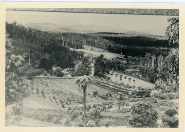
Photograph, Harmony Vale, c1913
View of Harmony Vale, the original Kalorama settlement taken from Barbers Road. Child's sawmill can be seen (centre) with the log yard to the right. Richardson's home "Harmony Vale' is in the orchard above the logs.Black and white photograph copied from a Rose Series postcard showing the area known as "Harmony Vale' - the original Kalorama settlement. Child's sawmill is in the centre.Rose Series Photo of Harmony Vale on the Olinda Creek taken from Logans Lot 28. Link Rd crossing centre Shiloah complex left centre. Richardsons (Jeannie’s) “Mt Calvin” between trees above tree fern. Isaac Jeeves house with the tree fern floor among trees against forest right centre. Mill yard with logs above cultivated flat. Mill to left. “Harmony Vale” homestead among orchard above logs. “Glenrivers” in gully at top of clearing. About 1913. Copied JLC 1973harmony vale, harmony vale, child's sawmill, sawmill, barbers road, richardson, shiloah -
 Kew Historical Society Inc
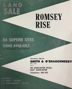
Plan - Subdivision Plan, Romsey Rise, Doncaster East
Real estate brochure for a land sale of 86 sites in East Doncaster. Roads identified in the plan include: George Street, Dennert Street, Worthing Avenue, Sandhurst Street, Belinda Crescent, and Romsey Rise.Historic subdivision plan of a Doncaster East EstateFour page colour real estate brochure including on page 2 a subdivision plan for the Romsey Rise estate in East Doncaster. This record also includes a separate price list for the lots.real estate plans, subdivision plans - doncaster east, romsey rise estate - doncaster east (vic) -
 Glen Eira City Council History and Heritage Collection
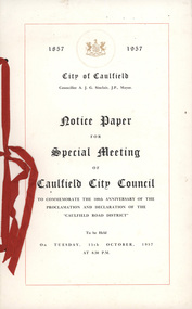
Notice, Arbuckle Waddell Pty Ltd, "Notice Paper for Special Meeting of Caulfield City Council", c. 1957
Notice paper generated by council documenting the minutes of a special meeting of Caulfield City Council to commemorate the 100th anniversary of the proclamation and declaration of the "Caulfield Road District" and held as part of the 1957 Centenary of Caulfield Celebrations.Paper notice printed in black ink on cream colour paper, bound with red ribbon. 2x A3 sheets of paper folded to make a booklet including a cover and inside pages include an agenda; image of the Caulfield Town Hall; Council summons and a list of the Caulfield City Council. -
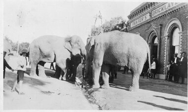 Stawell Historical Society Inc
Photograph, Elephants from a Circus at Fraser's Bricklayers Arms Hotel in Barnes Street drinking out of Horse Trough
Elephants from a Circus at Fraser's Bricklayers Arms Hotel Barnes Street drinking out of Horse Trough. At that time the circuses used to be at the Stawell Showgrounds in lake Road now the Shire Yards opposite the Brickworks.stawell -
![Photograph, Charles Ernest Barrie and Jessie May Lang [Barrie], Unknown](/media/collectors/5b29fbbc21ea6714f814b353/items/62e4fd87c63606307f37aabf/item-media/62e4fdebc63606307f37adf4/item-fit-380x285.jpg) Melton City Libraries
Melton City LibrariesPhotograph, Charles Ernest Barrie and Jessie May Lang [Barrie], Unknown
In 1906 , Jessie May married Charles Ernest Barrie in the Methodist Church Melton on the 23rd August. They lived in the newly built house beside the Chaff Mill on the corner of Station and Brooklyn road Melton South. Black and white photograph of Charles Ernest Barrie and Jessie May Lang [Barrie]local identities -
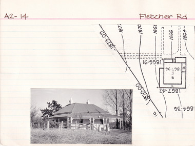 The Beechworth Burke Museum Research Collection
Card (Series) - Index Card, George Tibbits, Fletcher Road, Beechworth, 1976
George Tibbits, University of Melbourne. Faculty of Architecture, Building and Town & Regional PlanningIndex system that support the research for Beechworth : historical reconstruction / [by] George Tibbits ... [et al]Arranged by street names of BeechworthEach index card includes: street name and number of property, image of property, allotment and section number, property owners and dates of ownership, description of the property according to rate records, property floor plan with dimensions.beechworth, george tibbitsbeechworth, george tibbits -
 Melton City Libraries
Photograph, Barry Sherwell, Edgar Barrie and Peter Barrie at Ferris Road, 1971
Taken at EWS Ferris Road. The fire brigade was formed in 1970, Edgar Barrie was the Urban brigade's first Captain from 1970 to 1973. Peter Barrie joined in 1962. Barry Sherwell was foreman in 1971. Barry Sherwell, Edgar Barrie and Peter Barrie, Melton Urban fire brigade members.local identities, emergency services -
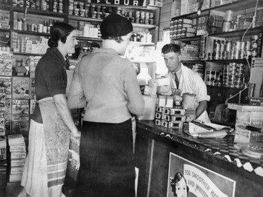 City of Kingston
Photograph - Black and white, c.1930
This photograph shows Judd's Grocery Shop located at 224 Charman Road, Cheltenham in the 1930's. Alan Hutchins is the shop attendant, serving two patrons; Merle Judd (left) and Marion Elliott (right). Judd's Grocery Shop was opened by Clarence Judd in the 1920's and was a successor to the family's business formerly located on the corner of Centre and East Boundary Roads, East Bentleigh. Cheltenham had become an established village during the 1920's and Charman Road represented a second, more commercial development in the area. Black and white photograph of a grocery shop interior displaying a variety of items for sale. A male stands behind a counter, looking at the camera. Two females stand in front of the counter facing the male. One female is wearing a hat. Handwritten in blue ink: 181 Handwritten in red ink: 72%shopping, strip shopping, cheltenham, charman rd, grocery -
 Lakes Entrance Historical Society
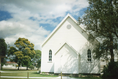
Photograph - St Nicholas Church Hall, 2000
Hall was original Church, built 1893 on opposite side of road, moved and enlarged 1908, moved again for new Church 1960c to become Church Hall, kitchen added, re-roofed and repainted 2012.Colour photographs of St Nicholas Anglican Church Hall, showing a timber building, high sloping corrugated iron gable roof. Fixed arched windows of six panes, some coloured, above a lower window opening inwards. Front and side doors arched. Small round ventilator under roof peak above porch. Lakes Entrance Victoriareligion, buildings -
 Whitehorse Historical Society Inc.
Letter, Scovell Family, 1990
A letter from Ian Hill and a document regarding the Scovell family of Blackburn.non-fictionA letter from Ian Hill and a document regarding the Scovell family of Blackburn.lyell andrew, hill ian, sweetland george william, laburnum street blackburn, scovell family, presbyterian church blackburn -
 Charlton Golden Grains Museum Inc
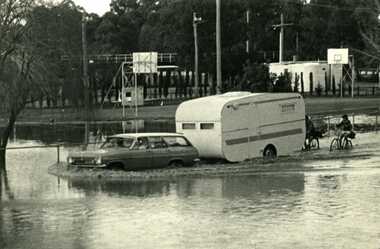
Photograph - B/W Photograph of 1973 flood near Gordon Park, 1973 Flood, c. Feb 1973
1973 flood near Gordon Park, Car and caravan driving through flood water and road followed by two bicycles. Campers forced out of Gordon Park by rising flood waters c.1973Unframed B/W photograph flood, gordon park, charlton -
 Clunes Museum
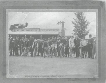
Photograph, CYCLE RACE
START OF CYCLE RACE CLUNES. H. HARRIS, F. ROBERTS,W. RICHARDS, E. OLSON, R.THOMAS. PHOTOGRAPH TAKEN IN FRONT OF ALL NATIONS HOTEL CR. TALBOT ROAD AND SUBURBAN STREET, CLUNES.PHOTOGRAPH OF START CYCLE RACE ABOUT 1912 OR 1913 PICTURE TAKEN IN FRONT OF ALL NATIONS HOTELCYCLE RACE CLUNES ABOUT 1913 NAMES WRITTEN ON OF PARTICIPANTS. H HARRIS , F ROBERTS, W RICHARDS, E OLSEN R THOMAS,photography, sport, bicycle, bycicle race 1912 or 1913 -
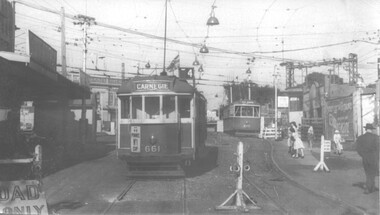 Melbourne Tram Museum
Photograph - Black and White - trams 661 and 675 Elsternwick, John Alfred, 1960
Black and white photograph of trams W3 661 (Route 4 Carnegie) and X2 675 (Point Ormond) , Glenhuntly Road, Elsternwick Station, during the lowering of the railway line, 1960. Photo by John Alfred. Yields information about alterations to tram services during a level crossing removal project.Photograph - Black and White - trams 661 and 675 ElsternwickHas details handwritten on rear, and John Alfred Stamp. tramways, tramcars, glenhuntly rd, level crossing, elsternwick, tram 661, tram 675, w3 class, x2 class, point ormond -
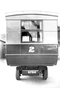 Ballarat Tramway Museum
Photograph - Geelong Tramways MESCo bus No. 2
Rear of MESCo's bus No. 2, built for their East Geelong route between the East terminus at Boundary Road and the railway station or Moorabol St. wharf. Note the twin rear tyres. Looks new, 1912.Black and white print on paper.No. 1 inside a circle written on the reverse in pen. 14-2 and GRS710/14/1/2 written n the reverse in pencil.geelong tramways, mesco bus no. 2 -
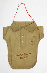 Port Fairy Historical Society Museum and Archives
Functional object - Knitting Bag, 1914-1918
made by the red cross volunteers to raise money for the 1914/1918 war. Probably made locally. Actually thought to be made for soldiers to put their dirty socks in their kit bag.(reference: Antique Road show)Khaki bag made to look like a shirt. "Sister Susie's shirt' embroidered on it in red. 2 red crosses also embroidered on it. Red silk cord to hang it up.Sister Susie's Shirt embroidered in redlocal history, handcrafts, country crafts, red cross, 1914-1918 war -
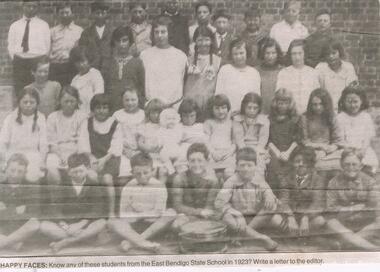 Bendigo Historical Society Inc.
Newspaper - JENNY FOLEY COLLECTION: HAPPY FACES
East Bendigo State School, no.3893, operated in Strickland Road 1916-1998. In 1920 an Avenue of Honour was planted by the students, on the approach to the school. Although the trees are no longer there, the name plates are preserved at the Bendigo RSL.Bendigo Advertiser ''The way we were'' from 2003. Happy faces: know any of these students from the East Bendigo Sate School in 1923? The clip is in a folder.newspaper, bendigo advertiser, the way we were -
 Melbourne Tram Museum
Photograph, Sutcliffe Pty Ltd, Essondon Tram Depot - new building, June 2024
The photograph is of the six road extension built on the south side of the previous depot building at Essendon. Tracks and overhead are yet to be installed - the foreground of the photograph appears to have been "photoshopped". The photograph is about June 1924.Yields information about the second shed at Essendon Depot.Black and white photograph with photographers stamp on rear.Has the stamp of "Sutcliffe Pty Ltd" on rear.trams, tramways, depot, essendon depot, new buildings -
Melbourne Tram Museum
Pamphlet, Public Transport Victoria (PTV), "Tram service changes route 72", April 2022
Issued for track renewal in Malvern Road between Chapel St and Mandeville Crescent, Armidale between 29 April and 14 May 2022. Gives details of the replacement and alternative bus routes. Produced by the PTV.Yields information about track work in Malvern Road during 2022.Pamphlet - full colour DL 5 fold.trackwork, tramways, malvern road, route 72 -
 Melbourne Tram Museum
Photograph - Cable trams - Princes Bridge, c1923
The photograph shows Princes Bridge, St Kilda Road, looking south, with a horse drawn cart, a cable tram set, two motor vehicles and pedestrians. Same hand writing on the rear as item 8279.Yields information about Bridge c1923. Black and white photo with hand written notes on the rear. Printed on Kodak paper."Flinders St bge Melbourne 1923"tramcars, tramways, cable trams, princes bridge, st kilda road -
 Sunbury Family History and Heritage Society Inc.
Photograph, Rosa McCall, Ligar Street, February 2014
This is a view of Ligar Street looking towards Riddell Road and opposite the tennis courts, taken in February 2014. The weatherboard Californian cottage was probably built in the 1920s and is one of a few other cottages of this style in Sunbury.A non-digital coloured photograph of a street with a fenced in area adjacent to a weatherboard cottage. A pedestrian crossing is in the foreground and a small white car is parked further down the street. There are trees visible in the distance.ligar street, sunbury, californian cottages -
 Melbourne Tram Museum
Photograph - Riversdale Road Horse tram, c1900
The photograph shows a Hawthorn / Auburn horse tramway with a horse tram having turned from Power St into Riversdale Road. c1900? The Hawthorn tram depot was built in 1915/16 in the area where the trees are.Yields information a Auburn / Hawthorn horse tram in Riversdale Road.Black and white photograph with notes on the rear.In pencil on the rear "No 14, 050, Auburn terminus of the Hawthorn Tramway"tramcars, tramways, horse trams, riversdale road -
 Lakes Entrance Historical Society
Photograph, Phillip Hancock, James Howlett family, 1998 c
. setting out for a family picnic from their home Inglewood Punt Rd Metung Victoria. Taken by James Howlett at Inglewood Punt Road Metung. James Howlett built a camera and took family photographs Black and white photograph showing the James Howlett family, James, Marion Snr, Eva, Maud, Ethel, Herbert, Mabel, Albert, Alfred, Arthur, Marion Jnr and friend Phyllis Hancock and child Also a black and white photograph of Marion Elizabeth Howlett with a visitor in her jinker Molly the name in shaftsgenealogy, families -
 Box Hill Historical Society
Photograph - Houses - Kangerong Road, City of Box Hill, 9/02/1979
Photographs of buildings about to be demolished were taken by the City of Box Hill Traffic and By-Laws officers. Largely demolished weatherboard house at 14 Kangerong Road, Box Hill. Also refer 1483 and 1485. B&w photoCaption of back of photo says 'front view'.kangerong road, box hill, demolitions, houses, weatherboard -
Canterbury History Group
Article, Alison Barclay, Residents join forces to protect Canterbury, 8 May 2013
Canterbury residents groups join forces to protect history of Canterbury, many of the members of groups were involved in saving Canterbury heritage such as Maling Road precinct, and Shrublands - Canterbury Residents Action Group (CRAG).Article with colour photoboroondara residents action group, crag, canterbury history group, maling road, canterbury history -
Box Hill Historical Society
Photograph - Buildings, c December 1994
View to the north west of the intersection of Station Street and Whitehorse Road to the Box Hill Post Office. Since this photo was taken (approx. December 1994) it is no longer a Post Office but a video store for lending videos.box hill post office, post offices, station street, whitehorse road, worldvision travel, homeshow entertainment, traffic signals, motor vehicles -
 Kew Historical Society Inc
Photograph - The last train at Barker Station, 1952
The Kew railway was opened in 1887, and diverged from the main (Box Hill–Lilydale) line about half-way between Hawthorn and Glenferrie. From the point of divergence the line was slightly less than one mile long, and it had only one intermediate station — Barker. There were four road over-bridges and two level crossings, including one over the busy Barkers Road. The line supported a passenger and goods service, and was electrified in December 1922, at the same time as the main line to Box Hill. There were a number of peak hour services which ran from Flinders Street station (Melbourne) to Kew, but in 1938 all but one of these were diverted to the Ashburton line, where traffic was growing. This had an adverse effect on Kew traffic, as passengers from Kew needed to cross over a footbridge at Hawthorn to change trains, and the main line trains were usually already crowded by the time they reached Hawthorn. At about the same time the off-peak trains were replaced by road buses. In 1952 all passenger trains were withdrawn, but the road bus service continued for many years. Goods trains were finally withdrawn in 1957, and the railway was dismantled in 1958-59. (Source: Frank Stamford, 'The Hawthorn - Kew Railway')Small black and white snapshot of the last passenger train at Barker Railway Station in 1952. The photograph, one of 12, is part of a larger album of newspaper clippings, timetables, tickets and photos relating to the Kew Railway Line, taken and compiled by Lachlan Richardson, while a resident of Kew. The album dates from the 1950s. The album is part of a larger subject file on the Kew Line, compiled over time by members of the Kew Historical Society."Last train at Barker Station / 1 August 1952"kew railway line, transport -- railways -- kew (vic.), barker railway station, kew branch line -
 Kew Historical Society Inc
Photograph - Barker Station, August 1952
The Kew railway was opened in 1887, and diverged from the main (Box Hill–Lilydale) line about half-way between Hawthorn and Glenferrie. From the point of divergence the line was slightly less than one mile long, and it had only one intermediate station — Barker. There were four road over-bridges and two level crossings, including one over the busy Barkers Road. The line supported a passenger and goods service, and was electrified in December 1922, at the same time as the main line to Box Hill. There were a number of peak hour services which ran from Flinders Street station (Melbourne) to Kew, but in 1938 all but one of these were diverted to the Ashburton line, where traffic was growing. This had an adverse effect on Kew traffic, as passengers from Kew needed to cross over a footbridge at Hawthorn to change trains, and the main line trains were usually already crowded by the time they reached Hawthorn. At about the same time the off-peak trains were replaced by road buses. In 1952 all passenger trains were withdrawn, but the road bus service continued for many years. Goods trains were finally withdrawn in 1957, and the railway was dismantled in 1958-59. (Source: Frank Stamford, 'The Hawthorn - Kew Railway')Small black and white snapshot of the last passenger train at Barker Railway Station in 1952. The photograph, one of 12, is part of a larger album of newspaper clippings, timetables, tickets and photos relating to the Kew Railway Line, taken and compiled by Lachlan Richardson, while a resident of Kew. The album dates from the 1950s. The album is part of a larger subject file on the Kew Line, compiled over time by members of the Kew Historical Society."Barker Station / August 1952"kew railway line, transport -- railways -- kew (vic.), barker railway station, kew branch line -
 Kew Historical Society Inc
Photograph - Kew Railway Station: Denmark Street entrance, 1952
The Kew railway was opened in 1887, and diverged from the main (Box Hill–Lilydale) line about half-way between Hawthorn and Glenferrie. From the point of divergence the line was slightly less than one mile long, and it had only one intermediate station — Barker. There were four road over-bridges and two level crossings, including one over the busy Barkers Road. The line supported a passenger and goods service, and was electrified in December 1922, at the same time as the main line to Box Hill. There were a number of peak hour services which ran from Flinders Street station (Melbourne) to Kew, but in 1938 all but one of these were diverted to the Ashburton line, where traffic was growing. This had an adverse effect on Kew traffic, as passengers from Kew needed to cross over a footbridge at Hawthorn to change trains, and the main line trains were usually already crowded by the time they reached Hawthorn. At about the same time the off-peak trains were replaced by road buses. In 1952 all passenger trains were withdrawn, but the road bus service continued for many years. Goods trains were finally withdrawn in 1957, and the railway was dismantled in 1958-59. (Source: Frank Stamford, 'The Hawthorn - Kew Railway')Small black and white snapshot of the entrance to Kew Station from Denmark Street in 1952. The photograph, one of 12, is part of a larger album of newspaper clippings, timetables, tickets and photos relating to the Kew Railway Line, taken and compiled by Lachlan Richardson, while a resident of Kew. The album dates from the 1950s. The album is part of a larger subject file on the Kew Line, compiled over time by members of the Kew Historical Society.kew railway line, transport -- railways -- kew (vic.), kew branch line, kew railway station