Showing 15976 items
matching annual-report
-
 Uniting Church Archives - Synod of Victoria
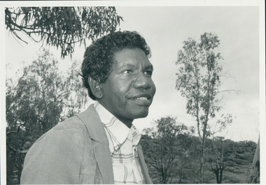
Photograph, Rev. Djiniyini Gondarra, 1986
Rev Dr Djiniyini Gondarra OAM, was born in Milingimbi, eastern Arnhemland in 1945. He was educated at Milingimbi Mission School and pursued his theological education as a youth leader and Sunday School teacher through the Methodist Church, before attending college in Brisbane. In 1969 he trained as a Minister in Papua New Guinea and the Solomon Islands under the Uniting Church, before returning to Arnhemland to minister his own people at the Galiwin’ku parish, firstly as a lay pastor (1971-1972) and then as a Minister from 1976-1982. In 1983-84, Rev Djiniyini worked as a Lecturer in Theology at Nungalinya College, Darwin. He was honoured with a Diploma of Theology (Honorary) from there in 1984, and in 1991 received a Cultural Doctorate in Literature (Honorary) from the World University, Roundtable, Arizona USA. Rev Djiniyini was awarded the Order of Australia Medal (OAM) in 1995. As well as being the Chairman of ALPA since 1993, Rev Djiniyini is currently the Director of Duduy’ngu Pty Ltd, which provides consultancy and cross-cultural services. He is also Director of Yirrkala Business Enterprises. Over the years, Rev Djiniyini has served on many committees and councils including: Member of the Steering Committee of the Australian Indigenous Cultural Network (1998-2001), CEO of Aboriginal Resource and Development Services Inc (1998-2001), CEO of the Northern Regional Council of the Uniting Aboriginal and Islander Christian Congress (1998-2001), Director of Reconciliation Australia Limited (2000-2001), Member of Council for Aboriginal Reconciliation (1998-2000), Chairman of Uniting Aboriginal and Islander Christian Congress (1995-2000 & 1990-1993), Member of Central Committee of the World Council of Churches (1991-1994), Moderator of Northern Synod, Uniting Church in Australia (1985-1987), Secretary of newly formed Aboriginal Presbytery, Northern Synod, Uniting Church in Australia (1985), and Vice-President of Uniting Aboriginal and Islander Christian Congress Uniting Church in Australia (1983-1987). Rev Dr Djiniyini Gondarra OAM has also been extensively published, and his works include: • Information Papers (co authored), Aboriginal Resource and Development Services: • Confusion Between Cultures (1998) • MHead & Shoulders of Djiniyini Gondarra facing right of picture."Rev. Djiniyini Gondarra 1986. Moderator Northern Synod and Vice President of Uniting Aboriginal and Islander Christian Conference."gondarra, djiniyini, uaicc, northern synod uca -
 Kew Historical Society Inc
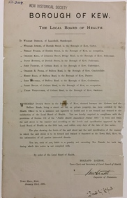
Document, Holland Loxton, Notification to the Residents of Derrick Street by the Local Board of Health, 1885, 1885
Streets and drains were the basic infrastructure problems for Kew in the 1880s. Decent streets and drains were fundamental to the quality of life of the residents. Without drainage, streets became muddy, boggy and sometimes impassable. Pools and puddles of stagnant water became smelly. The run off water, mixed with human and animal wastes, because there was no sewerage, became a health hazard. Streets and drains then became what were known as 'a nuisance'. Kew suffered from bouts of typhoid fever during the 1880s. Derrick Street was a private street on the margin of the business district of Kew and a well-used thoroughfare. We hear first about Derrick Street when the ratepayers applied to Council to have the street 'taken over' in January 1881. The Council agreed, after much debate, but ratepayers had to pay half the costs. The argument of the majority of the Council was that there was an established policy that ratepayers of private streets either had to hand over the street fully-formed or pay half the costs if Council did the work. It was felt that to make an exception for Derrick Street would create a precedent for ratepayers of other private streets. On the other hand the ratepayers, and a minority of Council, believed that there were extenuating circumstances in the case of Derrick Street. They believed that the costing by the Borough Surveyor was excessive. They felt the Council was partly responsible for the state of the street due to a channel on Bulleen Road, which deposited sand in the street. The Council had also put in some kerbing at the entrance to the street. Finally, the ratepayers believed that the street had become an important and convenient thoroughfare in Kew, and thus should be an exception to the policy on private streets. In the end a decision was delayed to allow the ratepayers to drain and form the street themselves. And there the matter stood till September 1882, when Miss Reilly complained about rubbish on a block of land in Derrick Street. So, in October 1882 the Council agreed to take over and form the street with the ratepayers paying half the costs. The ratepayers did not want to pay, so the argument continued in Council into 1883. There was a standoff for a further 18 months, until the problem could no longer be ignored. In October 1884 the Inspector of Nuisances and the Health Officer reported that Derrick Street was a health hazard as there was no drainage outlet for waste water. These reports changed the status of the problem of Derrick Street. It became an issue of public health, and thus the Council, acting as the Local Board of Health, had power to prepare plans and order the ratepayers to drain the street and pay all the costs, or let the Council do the work and charge ratepayers half the costs of the works. By April 1885, the time for ratepayers to complete the works themselves had expired, so the Council proceeded with the work and required ratepayers to pay for their share of the costs. All ratepayers had paid by the end of April except Mr Whiddycombe, who refused to pay. Mr Whiddycombe was warned to pay in October 1885. Legal action was taken against him in November. The Council lost the case on technical grounds. The Council, acting as the Local Board of Health, relaunched the legal action and won. The last we hear of Derrick Street is that seven day’s notice was given to Derrick Street ratepayers to pay for the drainage works in May 1887. We presume that Mr Whiddycombe paid. (Research: Andrew Frost)Rare and historic publication issued by the Board of Health in the Borough of Kew in 1885 to residents of Derrick street regarding the need for proper drainage for the purpose of improving public health.Printed formal notice sent by the Board of Health of the Borough of Kew to landowners in Derrick Street, Kew. The notice advised the owners that they were required to form and drain the street according to the levels and specifications approved by the Board. The letter was sent on January 23rd 1885, and signed by the Inspector of Nuisances.borough of kew -- greater melbourne (vic.), council notices -- public health, derrick street -- kew (vic.) -
 Stawell Historical Society Inc
Archive, Red Cross Records, 1939 - 2004
2 Archive Boxes: Archive Box 18 contains: BAG 1 1 Red Cross First Aid Group. Black Folder 1954 - 1968 Exams 1 Grey Cover July 1944 to April 1945 (Minutes). Group to Disband & Join Red Cross and become Stawell Red Cross Emergency Company. 1 Red Cover - Red Cross Service Company Annual & General Meeting Minutes July 1970 to 1 September 1989. March & September 1978 Meetings abandoned due to insufficient persons attending. 21 September 1989 Meeting called to finalise all Accounts & distribute equipment. BAG 2 1 Plastic Sleeve: Contains 1 X Loose sheets of Miscellaneous Information. 1 Green cover Shell Exercise book - Miscellaneous Information. 1 The Great Blood Bank Evolution with Blood Donor Book Mark. 1 X3 Exercise Books: Monthly List of Donors. 1 Green Cover Shell Exercise Book Aug 1960 - Feb 1968 1 Green Cover Shell Excerise Book April 1968 - July 1979 1 Angle Striped Cover Student Excercise Book Spet - 1979 - March 1982. BAG 3 Blood Bank: Blood Donors & Voluntary Staff at "Blood Takes" 1962 - 1989 1. Blue and White Dimond COver Exercise book: Sept. 1964 - June 1968 1. Blue and White Check with Green Border Embassy Exercise Book: July 1968 - June 1973. 1. Blue Dimond Cover Exercise Book. Aug 1973 - Mar. 1983 1. Red Bound Bound Blue Book. Aug 1with Blood Bank Sticker: April 1983 - June 1989. BAG 4 1 X Bank Statements BAG 5 1. Plastic Bag: 2 Junior Red Cross First Aid Booklets. 1. Grey Cover, Red bound Disaster Times Register & Catering Register. 1. Gordon Exercise Book. Brown Cover Bool Disaster Times & Catering Registers 1984--1988 ( 2 Entries) BAG 6 1. Plastic Sleeve: Assorted Newspaper cuttings, Photos, cerftifcates 3 X Plastic Scapbooks 1961 Mid 1990's BAG 7 1 Plastic Sleeve: Red Cross Recollections Cassette Tape Made By Mrs Rene Hall, Mrs AliceBurton, Mrs Mill Walker, Mrs Jean Hughes; recorded by Elizabeth and2 hand written recollections my Mrs Jean Hughes and Mrs Ivy Newman. 1 Blue Cover Invicta Reservoir Esercise book: Distributing Book: List of Materials and wool supplied to members & What They Made for solders. 1939 - 9/06/1943. 1: Australian Red Cross Knitting Book. 1. Australian Red Cross Victorian Division Pyjamas etc. 1. Small Book Tennis Tournament 1939 with Photocopy of 2 Newspaper Cuttings. BAG 8 1 Plastic Sleeve: 6 News Sheets. 1. Branch Management Book 1940 1. Unit Information Handbook 1985 1 Treasurer's Handbook 1997 1 Office Bearer's Handbook.' 1999 *1 . Stawell Unit Award & Commendation in green folder 1985. 1. Roll of Article from Stawell Times 1,9,1999' 1 Cardboard around wrap for Pewter Wien Goblet sold as a Fundraiser 1. Pewter Bell donated for meeting by Annie N=Neil, and engraved as the Annie Neil Bell 1. Blue Covered book: Study of Red Cross Services ( Stawell Branch) 1939 - 1945 By Christina Joy. * Calico Cloth with Australian Red Cross These were attached to Garments owned by Red Cross. e.g. Short Gowns used at Blood Bank Had one on the Pocket. Archive Bos 19 BAG 1 1 Mottled Black over Red bound. Mon Oct 2 1939 Public Meeting called to form branch in Stawell. Committee meeting to Aug 1946 Page 281. Pages282 - 283 Minutes of Special Meeting: Feb 1942 June 1940 Aug. 1940 2. Public Meeting called to reform the Red Cross Emergency Service 29/07/1942 to 20/03/1970 BAG 2 1: The Original Subscription Book 1939-1940 2: Annual Roll Call Books 1941 1: Gordon Exercise book - Memberships 1941/42 1942/43 2: Membership Rolls: 1944/45 - 1950/51 Membership Rolls 1952/52 - 1959/1960. 1: Red bound Mottled Grey Cover Book - Memberships 1942 - 1968 Sundry Entries 1: Blue Cover Roll Call 1975 - 2002 1: Striped Cover Roll Call 1991 - 2005 1: Membership Subscriptions 2002 - 2004 1 Yellow Cover Office Bearers and Committee Members BAG 3 1 Treasurer's Cash Book 1939 - 1943 1 Receipts & Expenditure 1939 - 1943 1 Red Cover Receipts and Expenditure 1965/66 - 1983 1 Red Bound Receipts and Expenditure 1989 1993 1 Green Cover Receipts & Expenditure 1994 -2003 1 Red and Black Cover Receipts & Expenditire 1995 - 2004 1 White Cash Book 2004 BAG 4 1 Red & Grey Marble cover Red Cross Committe Meeting May 1947 - Oct 1955 2 Special Meeting Minutes: Feb 1951 Nov 1951 1 Brown Bound Minute Book Red Cross Committe Meeting Nov 1955 - Feb 1963 Special Meeting November 1960 1 Red Bound Account Book Used as Minutes March 1963 - Sept 1970. BAG 5 1 Red Bound Black book: Annual Meeting Book 1942- 1989 1 Red Mottled Cover Book Annual Meeting Book 1990 - 2004 BAG 6 1 Red Cover Book: Oct 1970 - June 1978 1 Red Mottled Cover Book: July 1978 - Nov 1987 1 Red Mottled Cover Book July 1996 - May 2004 Tray Cloth with Red Cross Identification Tag Stitched on. (Donated by Graeme McDonough Aug 2010) stawell -
 Federation University Historical Collection
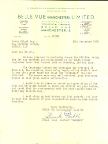
Letter - Correspondence, Frank Parker, 16/10/1952
Frank Wright was a renown resident of Smeaton, where he was born on 2 August 1901. He lived at Laura Villa, and attended Smeaton State School. His father William was a gold miner and his mother's name was Sarah. Their family won many singing and instrumental awards. Frank was tutored by Percy Code and was awarded a gold medal for the highest marks in the ALCM examinations in the British Colonies at the age of seventeen years. He became the Australian Open Cornet Champion by the age of eighteen. A year later, Frank conducted the City of Ballarat Band, and later the Ballarat Soldiers’ Memorial Band. He formed the Frank Wright Frisco Band and Frank Wright and his Coliseum Orchestra. These bands won many South Street awards, and Frank as conductor won many awards in the Australian Band Championship contest. In 1933 Frank Wright sailed to England to conduct the famous St Hilda’s Band and was later appointed Musical Director of the London County Council, where he organized many amazing concerts in parks, in and around the London district. He was made Professor of Brass and Military Band Scoring and conducted at the Guildhall of Music and Drama. Frank was often invited to adjudicate Brass Band Championships around Europe, in Australia, including South Street and in New Zealand. The Frank Wright Medal at the Royal South Street competition is awarded to an individual recognized as making an outstanding contribution to brass music in Australia.Letter from Frank Packer of Belle Vue (Manchester) Limited to Frank Wright, 1952Frank Wright Esq., 14, Highbury Grange, London, N.5. Dear Mr. Wright, We have pleasure in enclosing cheque for 10 pounds 10 shillings being the fee and expenses for adjudicating at our 100th Annual September Brass Band Contest held on Saturday, the 6th inst. The Centenary Contest was certainly the greatest of them all, the competing Bands being twenty of the World's best. It was the finest entry the Belle Vue "September" has ever obtained. The awards were very well received, your decisions appear to have given entire satisfaction. I would like ot place on record my appreciation of the able and efficient manner in which you carried out your duties, and trust that the arrangements made for your comfort were in every wat satisfactory. I send along my best wishes and kind regards, and hope to have the pleasure of your co-operation again on some future occasion. Yours faithfully, Belle Vue (Manchester) Limited Frank Parker Brass Band Contest Manager. belle vue, frank wright, letter, adjudicator, brass band -
Stawell Historical Society Inc
Realia - Calender, Brambuk Visitor Centre, A Year in Grampians - Gariwerd
Perpetual Calender. With eight proposed seasons according to Indigenous AustraliansOn a backgrous of Blurred of white and red Flowers "A Year in the Grampians Gariwerd". A Photo of the Grampians across farmland "This Calender combines Australian and European traditions" "Indigenous Australians observe changing weather and environmental patterns and resulting cycles of local seasons. On Each page of this calendar the large scene photos were taken in that month, over a period of twenty years. ( It must be remembered that flowers vary with the elevation, the soil, the aspect and the weather from year to year. You will not always find the same flowers in the same month as portrayed here.) In Europe, a calendar in the home is a long tradition: be it the familiar annual version or the Perpetual one to record important recurring dates such as family birthdays. It is our hope that however you choose to use our calendar, you will take peasure in the colour and beaty of the year in the Grampians Gariwerd." "All photographs by kees and Margo Sietsma. All Profits from the sale of this Calendar go to the Community Association of Halls Gap for the upkeep of our Botanical Gardens of Grampians flora. Dedicated to the memory of Kees Sietsma. with thanks to God, creator and Sustainer. -
 Old Castlemaine Schoolboys Association Inc.
Document, Circular 1919
Dear Sir, The Committee of the Association has decided to hold the Seventh Annual Re-Union of Members in the Mechanics Hall on Saturday, 11th October 1919 at Eight PM. The alteration of the Night meeting from Friday to Saturday proved such a huge success last year that the committee has decided to again hold the meeting on Saturday, and it is to be hoped that members will do their utmost to be present and help to make the function a sucess. The extension of the radius for membership from four to seven miles has resulted in a large influx of new members, but it is certain that there are many more eligible, and members are urged to use their influence in getting additional members. Members are again invited to forward to the Secretary the names of their sons or any old pupils of the district school who have enlisted for service abroad, as a complete list is desired for an Honor Board to be hung in the Castlemaine Town Hall. nominations for the General Committee must be in the hands of the Secretary on or before October 4th to enable him to have ballot papers printed for distribution on the night of the re-union. Nominations must be signed by the nominee and nominators (2) -
 National Wool Museum
Archive - Wool in Australia, 1990s
Part of a collection of books, manuals, photographs, letters and clothing relating to the working life of Stuart Ascough. Stuart's career in the wool industry spanned over 43 years from 1960 to 2003 in various roles including Topmaking Plant Manager at Courtaulds Ltd. in Spennymore, U.K., Operations Manager at Port Phillip Mills in Williamstown Victoria, Marketing Executive, Early Stage Wool Processing at the International Wool Secretariat Melbourne, Australia and General Manager of Victoria Wool Processors Pty. Ltd. in Laverton North, Victoria. Throughout his career Stuart travelled extensively, and in the 1990s worked at many topmaking mills in China on quality improvement projects. He also provided technical advice and training at mills in India, Ukraine, Lithuania, Kyrgyzstan, Russia, Latvia, Byelorussia and other parts of Europe and Asia.Concertina A4 sized leaflet outlining the history of wool in Australia from 1788 to 1988 in four pages with colour graphics and black text.page 1: Wool in Australia / 1 7 8 8 - 1 8 3 8 / Within 50 years of settlement sheep had moved into / every colony, the annual wool clip was over two / million kg, and wool had become our main export page 2: Wool in Australia / 1 8 3 8 - 1 8 8 8 / The first 100 years saw Australia become the / world's leading producer of wool. Our economy's / strength depended on the wool clip. page 3: Wool in Australia / 1 8 8 8 - 1 9 3 8 / By the late 1930's, wool represented over 62% of / the total export value of primary products. Australia's / fine wool was in great demand worldwide. page 4: Wool in Australia / 1 9 3 8 - 1 9 8 8 / In the 50 years leading up to our Bicentenary, / many developments in the sheep and wool / industry have maintained Australia's place / as the leading producer of wool.stuart ascough, international wool secretariat, victoria wool processors, port phillip mills pty ltd, topmaking, career, wool industry, mills, leaflet -
 The Beechworth Burke Museum
Photograph
Taken on 25 October 1930, various houses with the Hume Dam under construction are depicted in the background. The construction of the Hume Dam took place from 1919 to 1936. At the time of construction, it was the second largest dam in the world. It was also one of the earliest civil projects developed after the Federation. Some of the Dam workers consisted of World War I veterans. Dam workers often settled their families in Mitta Junction Village and Wodonga. Archaeological surveys were completed by Austral Archaeology, which was done when the Department of Land & Water Conservation was doing work to improve Hume Dam. The archaeological report that came out of the survey recommended three sites of interest where archaeological excavation should be done: Camp Ganger’s Quarters, Stableman’s Quarters, and the Industrial Dump. The excavation uncovered artefacts. Mitta Mitta: Mitta Mitta is situated between Mount Welcome and Mount Misery. It is named after the river that explorers Hume and Hovell discovered in 1824. The town would eventually become a huge gold mining town. Mitta Mitta is called Midamodunga by the local Indigenous peoples Wodonga: Wodonga is situated on the Murray River and is part of North East Victoria. Hume and Hovell: Hamilton Hume (1979-1873) and William Hilton Hovell (1786-1875). W. H. Hovell was born in Norfolk England and Hume was born in Parramatta, New South Wales Hovell and Hume undertook an exploration journey in 1824 and thought they discovered a river, which turned out to be the Murray River. They returned home in 1825, but returned to the area in 1826 and discovered coal in the area. This photo is historically significant as it shows the Hume Dam under construction in 1930. The Dam was named after Hamilton Hume, who is an important historical figure for this area as he helped discover the area where resources were found.Sepia rectangular photograph printed unmountedReverse: 84-19-5 / 1997.3185/ Values & spillway. / When completed the wall / will be as high as the / scaffolding. [featuring trademark: kodak print]construction, houses, veterans, mitta junction village, hume dam, world war i, federation, wodonga, archaeological survey, excavation, austral archaeology, department of land & water conservation, camp ganger's quarter's, stableman's quarters, industrial dump, artefacts, mitta mitta, mount welcome, mount misery, murray river, hamilton hume, william hilton hovell, hume and hovell expedition -
 The Beechworth Burke Museum
Photograph, c1930
Taken on 25 October 1930, various houses with the Hume Dam under construction are depicted in the background. The construction of the Hume Dam took place from 1919 to 1936. At the time of construction, it was the second largest dam in the world. It was also one of the earliest civil projects developed after the Federation. Some of the Dam workers consisted of World War I veterans. Dam workers often settled their families in Mitta Junction Village and Wodonga. Archaeological surveys were completed by Austral Archaeology, which was done when the Department of Land & Water Conservation was doing work to improve Hume Dam. The archaeological report that came out of the survey recommended three sites of interest where archaeological excavation should be done: Camp Ganger’s Quarters, Stableman’s Quarters, and the Industrial Dump. The excavation uncovered artefacts. Mitta Mitta: Mitta Mitta is situated between Mount Welcome and Mount Misery. It is named after the river that explorers Hume and Hovell discovered in 1824. The town would eventually become a huge gold mining town. Mitta Mitta is called Midamodunga by the local Indigenous peoples Wodonga: Wodonga is situated on the Murray River and is part of North East Victoria. Hume and Hovell: Hamilton Hume (1979-1873) and William Hilton Hovell (1786-1875). W. H. Hovell was born in Norfolk England and Hume was born in Parramatta, New South Wales Hovell and Hume undertook an exploration journey in 1824 and thought they discovered a river, which turned out to be the Murray River. They returned home in 1825, but returned to the area in 1826 and discovered coal in the area.This photo is historically significant as it shows the Hume Dam under construction in 1930. The Dam was named after Hamilton Hume, who is an important historical figure for this area as he helped discover the area where resources were found.Sepia rectangular photograph printed unmountedReverse: 84-19-2/ 1997.3188/ These are the four / release valves they are / not always open (illegible) this / when closed the water flows / over the spillway. [featuring trademark: kodak print] photograph number: 354construction, houses, veterans, mitta junction village, hume dam, world war i, federation, wodonga, archaeological survey, excavation, austral archaeology, department of land & water conservation, camp ganger's quarter's, stableman's quarters, industrial dump, artefacts, mitta mitta, mount welcome, mount misery, murray river, hamilton hume, william hilton hovell, hume and hovell expedition -
 The Beechworth Burke Museum
Photograph, 25 October 1930
Taken on 25 October 1930, various houses with the Hume Dam under construction are depicted in the background. The construction of the Hume Dam took place from 1919 to 1936. At the time of construction, it was the second largest dam in the world. It was also one of the earliest civil projects developed after the Federation. Some of the Dam workers consisted of World War I veterans. Dam workers often settled their families in Mitta Junction Village and Wodonga. Archaeological surveys were completed by Austral Archaeology, which was done when the Department of Land & Water Conservation was doing work to improve Hume Dam. The archaeological report that came out of the survey recommended three sites of interest where archaeological excavation should be done: Camp Ganger’s Quarters, Stableman’s Quarters, and the Industrial Dump. The excavation uncovered artefacts. Mitta Mitta: Mitta Mitta is situated between Mount Welcome and Mount Misery. It is named after the river that explorers Hume and Hovell discovered in 1824. The town would eventually become a huge gold mining town. Mitta Mitta is called Midamodunga by the local Indigenous peoples Wodonga: Wodonga is situated on the Murray River and is part of North East Victoria. Hume and Hovell: Hamilton Hume (1979-1873) and William Hilton Hovell (1786-1875). W. H. Hovell was born in Norfolk England and Hume was born in Parramatta, New South Wales Hovell and Hume undertook an exploration journey in 1824 and thought they discovered a river, which turned out to be the Murray River. They returned home in 1825, but returned to the area in 1826 and discovered coal in the area.This photo is historically significant as it shows the Hume Dam under construction in 1930. The Dam was named after Hamilton Hume, who is an important historical figure for this area as he helped discover the area where resources were found.Sepia rectangular photograph printed unmountedReverse: 84-19-6/ 1997.3187/ The spillway [featuring trademark: kodak print] construction, houses, veterans, mitta junction village, hume dam, world war i, federation, wodonga, archaeological survey, excavation, austral archaeology, department of land & water conservation, camp ganger's quarter's, stableman's quarters, industrial dump, artefacts, mitta mitta, mount welcome, mount misery, murray river, hamilton hume, william hilton hovell, hume and hovell expedition -
 The Beechworth Burke Museum
Photograph, 25 October 1930
Taken on 25 October 1930, various houses with the Hume Dam under construction are depicted in the background. The construction of the Hume Dam took place from 1919 to 1936. At the time of construction, it was the second largest dam in the world. It was also one of the earliest civil projects developed after the Federation. Some of the Dam workers consisted of World War I veterans. Dam workers often settled their families in Mitta Junction Village and Wodonga. Archaeological surveys were completed by Austral Archaeology, which was done when the Department of Land & Water Conservation was doing work to improve Hume Dam. The archaeological report that came out of the survey recommended three sites of interest where archaeological excavation should be done: Camp Ganger’s Quarters, Stableman’s Quarters, and the Industrial Dump. The excavation uncovered artefacts. Mitta Mitta: Mitta Mitta is situated between Mount Welcome and Mount Misery. It is named after the river that explorers Hume and Hovell discovered in 1824. The town would eventually become a huge gold mining town. Mitta Mitta is called Midamodunga by the local Indigenous peoples Wodonga: Wodonga is situated on the Murray River and is part of North East Victoria. Hume and Hovell: Hamilton Hume (1979-1873) and William Hilton Hovell (1786-1875). W. H. Hovell was born in Norfolk England and Hume was born in Parramatta, New South Wales Hovell and Hume undertook an exploration journey in 1824 and thought they discovered a river, which turned out to be the Murray River. They returned home in 1825, but returned to the area in 1826 and discovered coal in the area.This photo is historically significant as it shows the Hume Dam under construction in 1930. The Dam was named after Hamilton Hume, who is an important historical figure for this area as he helped discover the area where resources were found.Black and white rectangular photograph printer unmountedReverse: 84-20-1/ 1997.3147construction, houses, veterans, mitta junction village, hume dam, world war i, federation, wodonga, archaeological survey, excavation, austral archaeology, department of land & water conservation, camp ganger's quarter's, stableman's quarters, industrial dump, artefacts, mitta mitta, mount welcome, mount misery, murray river, hamilton hume, william hilton hovell, hume and hovell expedition -
 The Beechworth Burke Museum
Photograph, 25 October 1930
Taken on 25 October 1930, various houses with the Hume Dam under construction are depicted in the background. The construction of the Hume Dam took place from 1919 to 1936. At the time of construction, it was the second largest dam in the world. It was also one of the earliest civil projects developed after the Federation. Some of the Dam workers consisted of World War I veterans. Dam workers often settled their families in Mitta Junction Village and Wodonga. Archaeological surveys were completed by Austral Archaeology, which was done when the Department of Land & Water Conservation was doing work to improve Hume Dam. The archaeological report that came out of the survey recommended three sites of interest where archaeological excavation should be done: Camp Ganger’s Quarters, Stableman’s Quarters, and the Industrial Dump. The excavation uncovered artefacts. Mitta Mitta: Mitta Mitta is situated between Mount Welcome and Mount Misery. It is named after the river that explorers Hume and Hovell discovered in 1824. The town would eventually become a huge gold mining town. Mitta Mitta is called Midamodunga by the local Indigenous peoples Wodonga: Wodonga is situated on the Murray River and is part of North East Victoria. Hume and Hovell: Hamilton Hume (1979-1873) and William Hilton Hovell (1786-1875). W. H. Hovell was born in Norfolk England and Hume was born in Parramatta, New South Wales Hovell and Hume undertook an exploration journey in 1824 and thought they discovered a river, which turned out to be the Murray River. They returned home in 1825, but returned to the area in 1826 and discovered coal in the area. This photo is historically significant as it shows the Hume Dam under construction in 1930. The Dam was named after Hamilton Hume, who is an important historical figure for this area as he helped discover the area where resources were found. Black and white rectangular photograph printer unmountedReverse: 1997.3145/ 84-20-2construction, houses, veterans, mitta junction village, hume dam, world war i, federation, wodonga, archaeological survey, excavation, austral archaeology, department of land & water conservation, camp ganger's quarter's, stableman's quarters, industrial dump, artefacts, mitta mitta, mount welcome, mount misery, murray river, hamilton hume, william hilton hovell, hume and hovell expedition -
 Flagstaff Hill Maritime Museum and Village
Photograph - Ships, South Warrnambool Primary School Centenary Committee, Unloading coal at Warrnambool Breakwater, 1977
This photograph was framed and mounted then presented to the South Warrnambool school by the South Warrnambool Centenary Committee in 1977 on the school's centenary year. The school was decommissioned and closed in the 1990s. In the photograph, people unload the coal from the ship beside the Breakwater and load it into the row of tramway carts. The coal would be sold to businesses and householders for the purpose of fuel for warmth, cooking, heating water and running machinery. The image shows the early days at the Port of Warrnambool. The building of the Warrnambool Breakwater had only just been completed. Steamships and sailing ships were frequent visitors to the port. Steam Navigation companies were plentiful, carrying passengers and freighting cargo such as coal, timber, food, livestock, furniture, hardware and haberdashery between Melbourne and the ports along the southwest coast of Victoria, including Warrnambool. The carts would take their loads into the township for distribution. The ship carrying the coal is thought to be the "S.S. Chillagoe" previously named "Speculant". In 1903 the Chillagoe was registered at the Port of Melbourne, and it sailed between Melbourne and Newcastle, New South Wales, where coal was mined and sold in significant quantities. In March 1890 a tragedy occurred when coal was being unloaded at the Warrnambool Breakwater. A local young man, David Ferrier, was working in the hold of the steamship Kurrara as its delivery of coal was being unloaded. A basket of coal fell from a sling onboard and came down upon Ferrier, breaking his back. He was not expected to live. In September 1890 there was a strike of coal workers but the Geelong Advertiser reported that a Warrnambool firm of coal merchants had recently received some large cargoes from Newcastle.The photograph is historically significant as it is connected with the local areas of the Warrnambool Breakwater, Lady Bay, and the South Warrnambool Primary School. The scene shows a moment in time when a steamship was unloading a shipment of coal onto tram carts on the Breakwater, which had only just been completed that year. The photograph was taken about 13 years after the opening of the South Warrnambool School, which was decommissioned around 20 years after it celebrated its centenary.. Photograph, black and white, in a gilded rectangular wooden frame, behind glass. The maritime scene shows figures on ships beside the Warrnambool Breakwater jetty and figures on the jetty, standing next to rail carts containing coal. There is a steamship further out on Lady Bay. A card below the photograph has an inscription and there is a pencil inscription on the back of the frame. The coal ship is thought to be the SS. Chillagoe. The photograph was taken in 1890 and was presented to the South Warrnambool School in its centenary year, 1977, by the South Warrnambool Centenary Committee.Typewritten on card: "UNLOADING COAL AT WARRNAMBOOL BREAKWATER"- 1890 - "Presented to Sough Warrnambool School by the SOUTH WARRNAMBOOL CENTENARY COMMITTEE - 1977 - " Handwritten in pencil on the back:"Speculant" as "SS Chillagoe" at Breakwater"flagstaff hill, warrnambool, maritime museum, maritime village, great ocean road, shipwreck coast, warrnambool breakwater, 1890, tramway, steamship, sailing ship, coal, cargo, port of warrnambool, unloading coal, chillagoe, speculant, newcastle, kurrana, david ferrier, coal strike -
 Flagstaff Hill Maritime Museum and Village
Compass, 1940's
Henry Browne and Son Ltd, of Barking, made aviation and nautical compasses, clocks and dials. The company made compasses for aircraft notably, Spitfires, Tiger moths and Concord. Henry Browne was born in Lewis, Sussex in 1842 and died in Barking in 1935. His company was a well respected English instrument maker that had been making and selling fine quality compasses, ship's clocks, inclinometers, sextants, and chandlery items for over 140 years. It started in a factory in Brightlingsea, Essex and moved to Barking in 1929. The Trade Mark brand Sestrel was used on all their equipment. Their “Dead Beat“ compass design is well dampened serving to reduce oscillations. It is reported that this design compass was fitted to many Allied ships during WW II. The company went through a boom period in the 1970s but collapsed in the 1980s due to the popularity of cheaper plastic compasses over tradition brass ones. Over more recent years, there has been a consolidation of British instrument makers and the firm of Henry Browne & Son has changed hands a number of times. At last count, it became part of Lillie & Gillie of London in 1985 when John Lilley & Gillie Ltd acquires the assets of Henry Browne & Sons (Sestrel) Ltd, a major competitor for what may be the second time. The model name of Sestral came about via the following.Take first two letters of the word Sensitive then the firs two letter of steady and the firs three letters of reliable hence the trade name of "Sestral". Item relates to the second world war used in many ships of the time merchant and military, It reminds us of a time in our social and world history when most of the world was in conflict.Henry Browne and Sons “Dead Beat“ compass design is well dampened serving to reduce oscillations and was an innervation that many makes of compass of the time din't have as a result the "Sestrel" design was fitted to many Allied ships during WW II.A liquid-filled Sestrel compass, with a brass housing and gimbal ring, wired for an internal low voltage light to illuminate the compass card. Inscriptions printed on face and impressed in metal around outer rim TRADE MARK", "Sestrel Dead-Beat", "No 1724 N", "Barking & London" HENRY BROWNE & SON", additional inscription "AFT No 1724 N". flagstaff hill, warrnambool, shipwrecked-coast, flagstaff-hill, flagstaff-hill-maritime-museum, maritime-museum, shipwreck-coast, flagstaff-hill-maritime-village, compass, marine compass, henry browne & son barking london, sestrel dead-beat marine compass, navigation instrument, sestrel dead-beat marine compass -
 Eltham District Historical Society Inc
Document - Folder, Ron F. McCormack, Appeal against Eltham Shire Permit granted for a propsed Youth Enterntainment Centre, 41-43 Were Street, Montmorency, 1993-1994
In 1993 Eltham Shire Council issued a permit to Michael Muzur, Terry Lant and Andrew McMillan to redevelop the former Montmorency Theatre/Bingo Hall at 41-43 Were Street as an alcohol-free youth entertainment centre. Ron McCormack, retired former JP on behalf of 41 Joint Appellants consisting of local residents and traders successfully lobbied the community and won an Appeal to have the permit cancelled as unsuitable development. The Administrative Appeal Tribunal found that the proposed development came withing the Eltham Planning Scheme definition of an 'amusement parlour' and that the playing of pool an amusement machines would be the focus of the centre and unlikely to attract older age groups. The tribunal was not satisfied the applicants had sufficient knowledge or where with all required for the successful running of this type of operation. With respect to the objectors, the Tribunal did not accept that a responsibly managed and attractive amusement parlour could not coexist near the adjoining residential area and without detriment to the commercial centre. At a Council meeting on June 7, 1994 councillors requested a report outlining criteria to be used to assess planning applications for youth entertainment venues given the Tribunal's view that a poorly managed facility in a small neighbourhood shopping centre, particularly in such close proximity to a residential area would not only have the potential to increase perceived youth problems, but could jeopardise the prospects of future proposals. Ron McCormack moved to Montmorency from Coburg in the early 1980s and from then sat on the bench at Eltham Courthouse when Police requested assistance out of hours, until the eventuial closure of the Courthouse. montmorency theatre, montmorency bingo hall, 41-43 were street, youth entertainment centre, eltham shire council, planning permit, administrative appeals tribunal, ron f mccormack -
 Eltham District Historical Society Inc
Document - Property Binder, 1524 Main Road, Research
Handwritten notes, undated, on A & G Bills horse trough Main Road Research. Handwritten notes, undated, "Annie and George Bills" listing locations of other Bills horse troughs. Typed notes by Dianna Basset-Smith, July 2003, her memories of the Bills trough at Research. Letter, RSPCE to Andrew Lemon, 17 December 1993, lists other horse troughs known to the RSPCA, use of money from Bills estate managed by John Crook. Newspaper article: Legacy is set in concrete, The Weekly Times, 25 June 2003, history of Bills horse troughs from 1930s, biography of George Bills and Annis Swarm [correctly Swann], quoting Barbie Roach, Gorge Bills' great-grandneice, notes locations of other Bills troughs. Newspaper article: No drought in water troughs, Weekly Times, 9 July 2003, Response to 25 June 2003 article, readers reporting Bills troughs in their area, photograph of trough at Korong Vale. Newspaper article: The horse lover, (photocopy, no publication details), Decaying Bills horse tough in Geelong council yard proposed to be moved to RSPCA, history of George Bills, Annis Bills (nee Swann), legacy, great-grandneice Judith Crook writing Bills history. Email exchange, Eltham District Historical Society and Geraldine Sanderson 2015: enquiry re Bills trough at Research for planned history of Bills trough, and provision of EDHS-held information.Annis Elizabeth Swannmain road, research (vic.), horse troughs, annis and george bills, bills trough, audrey bills, annis bills, george bills, barbie roach, royal society for the prevention of cruelty to animals, judith crook, audrey morton, kathleen wood, acclimatisation society, john lugg, ian stacey, harry bills, annis swann, james boreas crook, william buesst, myer emporium, richard bills, buesst and bills brothers, daisy bills -
 Eltham District Historical Society Inc
Postcard - Photograph postcard, The Rapids, Devils' Bank, Eltham, 1907
Devils' Bank was situated some two miles from Eltham. It is probably the section along the Yarra River where there are a series of rapids stretching past Petty's Orchard to Griffiths Park and the confluence with the Diamond Creek. Only three properties existed in this area in 1945 aerial maps, Worlingworth and the adjoining property on the bank of the Diamond Creek in Banoon Road and No. 2 Kent Hughes Road. Devils' Bank. The death of Ann Edwards, 77 years, an old resident of the district was reported who lived in an old hut at Devil's Bank who had been found dead in her bed on 13 May 1897 FOUND DEAD IN BED. (1897, May 28). Evelyn Observer, and South and East Bourke Record (Vic. : 1882 - 1902), p. 2 (MORNING.). Retrieved September 3, 2022, from http://nla.gov.au/nla.news-article60696388 A very similar view was published in the Leader paper in January 1908 - Devil's Bank Falls, Eltham VIEWS ON THE UPPER YARRA. (1908, January 11). Leader (Melbourne, Vic. : 1862 - 1918, 1935), p. 28. Retrieved September 3, 2022, from http://nla.gov.au/nla.news-article198106006 On the reverse of the postcard it appears to be postmarked Eltham, Dec 27, 1907 addressed to Mrs Christie Millmoss of Bull Street, Bendigo "Arrived here 10.45 am - ? ? raining cause of ? - ? till evenings it is lovely - but quite fresh after the (rain - crossed out) great ? - I may assume it all go well"Digital file only Postcards scanned from the collection of Michael Aitken on loan to EDHS, 2 Sep. 2022michael aitken collection, devils bank, eltham, postcards, rapids, yarra river -
Glen Eira Historical Society
Article - Kilvington Baptist Girls Grammar School
This file contains seven items about Kilvington students. The first item is a copy of Kilvington News December 1994. It includes comments from the Principal about the current school prefects, a photograph of the principal with prefects, as well as reports on awards and school activities. The next six documents include recognition of students’ achievements and integration of boys to Kilvington Grammar and opening news sport complex. Kilvington student wins Glen Eira Rotary Award dated 28/09/2012, Caulfield Leader. Kilvington student receives a perfect VCE score dated 21/12/2010, Caulfield/Port Phillip Leader. Kilvington Grammar decides to open its doors to boys and become a co-educational school. Dated 01/02/2011 Port Phillip/Caulfield Leader. Advertising feature on forthcoming musical production at Kilvington Grammar school of Fame. The school has choreographer Karen Young on board, who appeared in Fame on London’s West End, dated 29/03/2011. Caulfield/Port Phillip Leader. Kilvington students take part in a half day short film workshop on 24 March as part of this year’s Panasonic Kid Witness News short video competition. Article dated 12/04/2012. Caulfield/ Port Phillip Leader. Brief Caulfield/Port Phillip Leader article dated 09/08/2011 mentioning the opening of Kilvington Grammar’s new one million dollar sports complex. Caulfield/Port Phillip Leader.kilvington baptist girls grammar school, leila road, ormond, ngo angela, glen eira rotary youth award, kilvington girls grammar, holper sarah, charlton jon, kilvington grammar, baptist union of victoria, fame, musical events and activities, ling jenny, gall celia, young karen, dancers, mohan bianca, carroll luke, moustra isabelle, hay tia, amoore izzi, bahn jessica, hyams jamie, councillors, glen eira, opray annie -
 Eltham District Historical Society Inc
Booklet - Folder, Raynes Dickson Kiddle & Briggs Solicitors et al, Clintons Road, Christmas Hills, 1934-1938
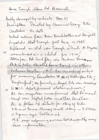
Correspondence over a four year period (probably an incomplete file) on the behalf of Henry Cairns of Moonee Ponds and property owner at Christmas Hills / Watsons Creek including copy of a survey of his land title in relation to complaint regarding the Shire of Eltham encroaching on his land to make a road and subsequent purchase of land. The road provided acccess to the property of Mr W. Clinton of Heidelberg and other properties at Christmas Hills. Note by H.G. indicates that the property discussed in file is Clintons Road (not stated in file), possibly named after 1938. In December 1937 Eltham Shire Council agreed to purchase a block of land at the intersection of the Christmas Hills -- Smiths Gully roads from Mr Cairns to provide an outlet for the road which ran through the Cairns property. In March 1928 Mr Clinton had previously offered to contribute a sum of money towards the cost of purchasing the Cairns block to permit the road to go into his property was intending to transfer the property to himself. A Councilor was reported as being astounded in The Advertiser, 11 March 1938, as the land was needed for a road. Cr Baird: "The road was only to help his sports" Mr W. E. Clinton (Bill) was one of the founders of the Rob Roy Hill climb which took place at his property at Christmas Hills. He owned a garage in Heidleberg (See: https://cv.vic.gov.au/stories/sporting-life/speed-style-spirit-the-rob-roy-hillclimb/the-rob-roy-hillclimb/)16 pieces of paperraynes dickson kiddle & briggs solicitors, henry cairns, shire of eltham, roadworks, christmas hills, watsons creek, w. e. clinton, clintons road, rob roy climb -
 Federation University Historical Collection
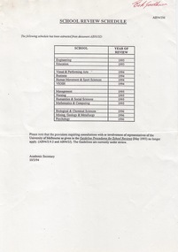
Document - Document - Guideline, VIOSH: Ballarat University College; School Review Schedule and Guidelines and Procedures, 1993
Victorian Institute of Occupational Safety and Health (VIOSH) Australia is the Asia-Pacific centre for teaching and research in occupational health and safety (OHS) and is known as one of Australia's leaders on the field. VIOSH has a global reputation for its innovative approach within the field of OHS management. VIOSH had its first intake of students in 1979. At that time the Institution was known as the Ballarat College of Advanced Education. In 1990 it became known as Ballarat University College, then in 1994 as University of Ballarat. It was 2014 that it became Federation University. VIOSH Australia students are safety managers, senior advisors and experienced OHS professionals. They come from all over Australia and industry. A review schedule for the University shows when each School is due for their review. The years range from 1993 through to 1996. Included with this are guideline procedures - rationale, schedule, procedures and participants, documentation, review report and consideration. Amendments to the Academic Board document are provided. There is a guideline for the introduction of new courses and changes to existing courses. (This is a schematic outline). Memorandum from Dr Frank Hurley, Chair of the Academic Board Review Committee, refers to guideline procedures re new courses and changes, reviews. As Ballarat University College is affiliated with The University of Melbourne, recommendations must be approved by Melbourne University. Students are taught active research and enquiry; rather than textbook learning and a one-size fits all approach. VIOSH accepts people into the Graduate Diploma of Occupational Hazard Management who have no undergraduate degree - on the basis of extensive work experience and knowledge.Seven A4 pages. Table and schematic outline includedBallarat University College paper. Signature of Frank Hurleyviosh, victorian institute of occupational safety and health, ballarat university college, melbourne university, review schedule, guidelines for procedure, academic board, dr frank hurley, chair of academic board review committee, new courses, changes to courses -
 Flagstaff Hill Maritime Museum and Village
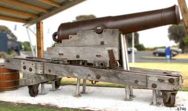
Weapon - Cannon, 1861
The artillery piece of the cannon was cast at the Low Moor foundry in England in 1861. It is a 68 pound muzzle loading cannon, capable of firing a 68 pound weight projectile. The arrow on the top of the barrel is the symbol of government ownership. It is probably one of the artillery pieces purchased by the Victorian government in response to the 1863 report by Captain Scratchley, which recommended 19 such artillery pieces be bought for the defence of Hobsons Bay, (Williamstown, Melbourne) (Billets p.12). It was possibly brought to Warrnambool in the late 1860s or the 1870s, to be used for training purposes by volunteers and local militia. The wrought iron runners were probably added to the slides at a later date. This model of carriage had been manufactured since 1855, and the traversing slide since 1860. The traversing slide of the wooden carriage absorbs the recoil when the gun is then returns to the gun to its original position for loading and re-firing. The properties of the timber (regarded as being Burmese teak) have helped to preserve these carriages in Australia. This particular carriage and traversing slide would have been manufactured about the same time as the gun (in 1861) in the Royal Carriage Department of the Royal Gun Factory in Woolwich, England. The gun would then have been assembled on the traversing slide of the carriage, then despatched as a unit. The wooden slide compressor mechanism that belongs to the cannon was used to limit the recoil when the cannon was fired. It is now stored separately for purposes of preservation. It is extremely rare, as it is the only one surviving in this group of South Western Victorian cannons.This 68 pdr cannon, mounted with its original wooden carriage, is part of the South Western Victoria collection of surviving 19th Century artillery pieces, item number W/F/02. It is rated as EXTREMELY RARE on a State, National and World level. The 68 pound smooth bore cannon of this period are not particularly rare either in Australia or overseas; its significance lies in its Victorian provenance and as an element in a major collection of 19th century cannon. The number of surviving carriages with traversing slides in this group in South Western Victoria is unique in Australia and probably in the World. Out of 10 such platforms surviving in Australia, the South Western Victorian group has half. Several survive around the world but probably not in such a large group. The wooden sliding compressor mechanism belonging to this cannon is extremely rare, and the only one in this South Western Victorian group of Guns and Cannons. As a whole, this cannon has undergone very little restoration or modification, giving it a high level of integrity.Warrnambool Garrison Cannon. 68pdr smoothbore, muzzle-loading, cast-iron cannon. Manufactured in Low Moor, 1861, No. 10310. Mounted on the wooden carriage with wrought iron traversing slide and wrought iron runners and fittings. The cannon's Cascabel is cast with a loop. The wooden slide Compressor Mechanism, or Recoil Mechanism, is extremely rare. This mechanism comprises two equal-sized sections of wood, one on each side of the centre, joined by metal rods. In the centre of this wooden platform, with openings, top and bottom is a 15cm diameter metal cylinder with two cusps on the edge of the top (this wood has split over time). Two parallel sides each have two 1cm thick metal "L' plates attached 15cm long and 8.5cm wide. With the unit is ‘ L’ bracket, curved bracket and bolt head.Cannon trunnion "LOW MOOR / 10310 / 1861" Top of the barrel "7045, (symbol of an arrow pointing up), 95 – 3 – 14, 1861, 209" Cascabel "CV / N / C" The rear of left-hand slide " "OD” “JW” “No 33” Side chock – “JW” twice. flagstaff hill, warrnambool, shipwrecked-coast, flagstaff-hill, flagstaff-hill-maritime-museum, maritime-museum, shipwreck-coast, flagstaff-hill-maritime-village, muzzle loading cannon, 68 pound cannon, low moor foundry, royal gun factory, warrnambool militia, warrnambool garrison volunteers, warrnambool fortifications, wooden sliding compression mechanism, carriage and traversing slide, 19th century cannon, traversing platform, garrison sliding carriage, 68 pounder -
 Flagstaff Hill Maritime Museum and Village
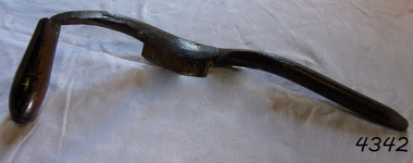
Tool - Cooper’s Hollowing /Jigger Knife, William Greaves & Sons, 1823 -1850
William Greaves was once a prolific company that highly prospered in the 19th century during the boom of the tool and cutlery trades in Sheffield England as steel became more commercially available. William Greaves's works were situated at the Sheaf Works in the heart of Sheffield, at Maltravers Street, opening in 1823 and was known to be the largest business in this area at this time. The Sheaf Works made a range of tools and saws including cutlery, penknives and razors and also even made its steel in-house. The factory used its perfect position for water power being built on the edge of the Sheffield canal and also used the railway line nearby giving them the perfect opportunities for transporting its goods. The factory itself was also a revolution because it attempted to bring together as many cutlery manufacturing processes as possible together in one place, something that had not been attempted before. The money to build these huge works came from Greaves' trade with America, where they sent razors, table cutlery and sturdy Bowie knives. This allowed the Greaves’ to build the factory and expand their production, which made them even more money. This made William Greaves very rich indeed, and it was reported that when he died in 1830 he left each of his five surviving daughters £30,000 each, an astronomical sum at the time. In today’s money that is approximately £2.3 million. The firm finally dissolved in 1850, but Sheaf Works continued to be used by many cutlery manufacturers until the 1980s. With most of the buildings still standing today.A significant item made by a successful cutlery manufacturer in England during the first half of the 19th century. This company undertook many new processes to streamline cutlery production and introduced innervations regards working with steel that are still in use today. This item is now regarded as a collector's item given the company ceased trading in 1850. jigger/hollowing knife with internal bevel, Electro Boracic Steel. Stamped 3.1/2″ William Greaves, Sheaf Works, Sheffield flagstaff hill, warrnambool, shipwrecked coast, flagstaff hill maritime museum, maritime museum, shipwreck coast, flagstaff hill maritime village, great ocean road, cooper's jigger, howeling knife, wm greaves & sons -
 Flagstaff Hill Maritime Museum and Village
Domestic object - Spoon
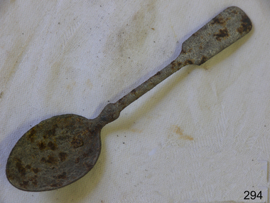
The teaspoon is a European invention. Small spoons were common in Europe since at least the 13th century; the special spoons were introduced almost simultaneously with tea and coffee. (Pettigrew points to its use in the mid-17th century.) Originally the teaspoons were exotic items, precious and small, resembling the demitasse spoons of later times. Also used for coffee, these spoons were usually made of gilt silver, and were available with a variety of handle shapes: plain, twisted, or decorated with knobs, also known as knops, hence the knop-top name for such spoons. Widespread use and the modern size dates back to the Georgian era. The teaspoon is first mentioned in an advertisement in a 1686 edition of the London Gazette. Teaspoons, probably of English origin, are present in the 1700 Dutch painting by Nicholas Verkolje, "A Tea Party". An 1825 cartoon makes fun of a Frenchman unfamiliar with the British etiquette. The guest did not place his spoon into the cup and is thus being offered his thirteenth cup of tea! A special dish for resting the teaspoons, a "spoon boat", was a part of the tea set in the 18th century. At that time, the spoons played an important role in tea drinking etiquette: a spoon laid "across" the teacup indicated that the guest did not need any more tea, otherwise, the hostess was obligated to offer a fresh cup of tea, and it was considered impolite to refuse the offering. Pettigrew reports that sometimes the spoons were numbered to make it easier to match the cups with the guests after a refill. https://en.wikipedia.org/wiki/Teaspoon#:~:text=Teaspoon%20is%20a%20European%20invention,the%20mid%2D17th%20century).A history of the teaspoon.Metal teaspoon, badly corrodedNoneflagstaff hill, warrnambool, shipwrecked-coast, flagstaff-hill, flagstaff-hill-maritime-museum, maritime-museum, shipwreck-coast, flagstaff-hill-maritime-village -
Glen Eira Historical Society
Article - VICTORIAN RAILWAYS
File contains 3 items: 1/Original handwritten notes by Leo J Harrington (VR Melbourne) and T O’Callaghan titled ‘Victorian Railways to ‘62’. Notes include dates of electrification of lines, station openings, valuations, railway station names and their origins. Reference to council minutes regarding request to change the name of Elsternwick station to Caulfield in June 1871. 2/Original newspaper article from ‘The Age’ dated 10/06/1978 by Graeme Davidson titled ‘A case study of Railway politics’. Article refers to a publication called ‘Return to Rosstown, Railway, Land Sales and Sugar Beet ventures in Caulfield’ by D. F. ‘Return to Rosstown’ recounts the story of the Rosstown Junction railway and its creator, William Murray Ross. Tells of Ross’ life since coming to Australia from Liverpool and how he prospered as a land speculator owning large tracts of land in Caulfield, the sugar mill and his plans to operate a railway. 3/Original newspaper article (and image) from ‘Moorabbin Standard’ dated 25/11/1981, titled ‘Centenary train to carry mayors’. Article reports that a special train will run from Spencer Street Station to Mordialloc railway Station on Saturday 19/12/1981 to celebrate the centenary of the railway line to Mordialloc. Story mentions that in 1881, the Caulfield to Mordialloc line was a single track and that passengers can also board the special train at Caulfield Station. Image is of steam train with red ‘tait’ carriages (undated).victorian railways, caulfield, glenhuntly, glen huntly, elsternwick, carnegie, murrumbeena, ormond, steam train, glenhuntly road, glen huntly road, ripponlea, north road, rosstown, rosstown junction railway, ross william murray, railways, trains, south caulfield, grange road, railway stations, mirrambeena, caulfield city council, sugar mill, electrification. -
 Federation University Historical Collection
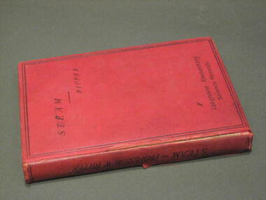
Book, William Ripper, Steam, 1897
This book was owned by Alf Gresham Johnston who was a former SMB mining student from the Ballarat School of Mines. He died at the age of 29 during military service in South Africa. The following is from the Federation Uni Honour Roll at http://federation.edu.au/about-us/our-university/history/geoffrey-blainey-research-centre/honour-roll/j/alfred-gresham-johnston-1872-1901 The October 1901 Ballarat School of Mines (SMB) Students Magazine reported 'Alf. Johnston's gone. The news came as a shock to all of us at the school. He who was with us a few short months ago, in all strength of sturdy manhood, has met a soldier's death in South Africa, and we sincerely mourn his loss…. His heart was in the school, and he did his best to further its interests … His last act on leaving Australian shores was to send a telegram from Albany to Prof. Mica Smith, to whom he was warmly attached, wishing the School and all connected with it "Good-bye". In his short, all to short, life of 29 years, he had more adventure than falls the lot of most men, and possibly the spirit of adventure, and also, of duty, prompted him to throw in his lot with the "colors," and leave for the front. The news of his death comes to us with added weight of sadness when we remember that he was one of the organisers of the School entertainment last year to help swell the fund for the erection of a statue to fallen Victorian soldiers.'A small red book with a double black line bordering the front cover, with the text Longmans Elementary Science Manuals on the bottom of the cover. On the back cover is an L&Co logoOn the title page is the inscription of the original owner of the book Alf G Johnston School of Mines Ballarat 1899. Inside the front cover and on page 19 is the stamp of the School of Mines Ballaratalfred johnston, steam engine, compound engines, condensers, heat, horse-power, transfer of heat, combustion of fuel, saturated steam, cranks and crank shafts, watt governor, boilers, alf johnston, william ripper, boer war -
 Federation University Historical Collection
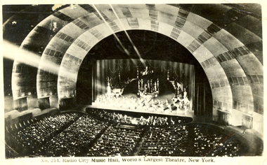
Postcard, Radio City Music Hall, c1949, 5/4/1949
A Post card from Frank Wright to his friend W. C. Snelling reporting on his travels to New York. Frank Wright was a renown resident of Smeaton, where he was born. He lived at Laura Villa, and attended Smeaton State School. His father William was a gold miner and his mother's name was Sarah. Their family won many singing and instrumental awards. Frank was tutored by Percy Code and was awarded a gold medal for the highest marks in the ALCM examinations in the British Colonies at the age of seventeen years. He became the Australian Open Cornet Champion by the age of eighteen. A year later, Frank conducted the City of Ballarat Band, and later the Ballarat Soldiers’ Memorial Band. He formed the Frank Wright Frisco Band and Frank Wright and his Coliseum Orchestra. These bands won many South Street awards, and Frank as conductor won many awards in the Australian Band Championship contest. In 1933 Frank Wright sailed to England to conduct the famous St Hilda’s Band and was later appointed Musical Director of the London County Council, where he organized many amazing concerts in parks, in and around the London district. He was made Professor of Brass and Military Band Scoring and conducted at the Guildhall of Music and Drama. Frank was often invited to adjudicate Brass Band Championships around Europe, in Australia, including South Street and in New Zealand. The Frank Wright Medal at the Royal South Street competition is awarded to an individual recognized as making an outstanding contribution to brass music in Australia.Postcard with black and white photo of the Radio City Music HallPrinted on front - No 214. Radio City Music Hall, World's Largest Theatre, New York. Handwritten on back - Message from Frank Wright to W.C. Snellingfrank wright, radio city music hall -
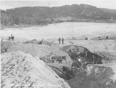 El Dorado Museum Association Inc.
Photograph (item) - Digital Image
Altering course of Reedy Creek, El Dorado. Cocks Pioneer Electric Gold & Tin Mine Company was formed in 1899. The company's first power station, located at the eastern end of the valley began operating with its 340 Kilowatt steam-powered generator. By 1909, from 2,500,000 cubic yards worked, reported recovery was 17,284 ounces of gold and 224 tons of tin ore. By 1909, Cocks Pioneer’s power plant had become inadequate and uneconomical. The barge was floated downstream about a mile, but lost time caused the operations to cease. Following testing, a new mine was established by diverting Reid's Creek at a cost of £25 000. Settling dams were built, one of which held 1,935,900 cubic feet. Sold earth banks, built against a wall of stringy bark saplings constructed and laced with vertical props, were built. In 1914, the company was reformed as Cock’s Pioneer Gold and Tin Mines NL, another power station was constructed at the western end of the township, near the junction of Clear and Reid's Creeks. From 6,800,000 cubic yards of material processed, the returns were 64,397 ounces of gold and 855 ton of tin. Cocks Pioneer mine then moved the barge downs stream and continued sluicing. In 1929 Cocks Pioneer Electric Gold and Tin Mining Company ceased operations due to a drop in values. Cock’s Pioneer Gold and Tin Mines NL carried on large-scale hydraulic sluicing operations until 1941. Handwritten across the front: 'Altering course of creek. Eldorado'mining, gold, tin, sluicing, reedy creek, cocks pioneer, el dorado, eldorado, men, horses -
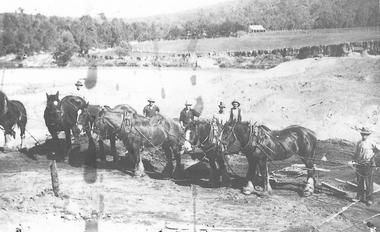 El Dorado Museum Association Inc.
Photograph (item) - Digital Image
Horse team , Cocks Pioneer Cocks Pioneer Electric Gold & Tin Mine Company was formed in 1899. The company's first power station, located at the eastern end of the valley began operating with its 340 Kilowatt steam-powered generator. By 1909, from 2,500,000 cubic yards worked, reported recovery was 17 284 ounces of gold and 224 tons of tin ore. By 1909, Cocks Pioneer’s power plant had become inadequate and uneconomical. The barge was floated downstream about a mile, but lost time caused the operations to cease. Following testing, a new mine was established by diverting Reid's Creek at a cost of £25,000. Settling dams were built, one of which held 1,935,900 cubic feet. Sold earth banks, built against a wall of stringy bark saplings constructed and laced with vertical props, were built. In 1914, the company was reformed as Cock’s Pioneer Gold and Tin Mines NL, another power station was constructed at the western end of the township, near the junction of Clear and Reid's Creeks. From 6,800,000 cubic yards of material processed, the returns were 64,397 ounces of gold and 855 ton of tin. Cocks Pioneer mine then moved the barge downs stream and continued sluicing. In 1929 Cocks Pioneer Electric Gold and Tin Mining Company ceased operations due to a drop in values. Cock’s Pioneer Gold and Tin Mines NL carried on large-scale hydraulic sluicing operations until 1941. mining, gold, tin, sluicing, men, cocks pioneer, el dorado, eldorado, horses, gold mining, tin mining -
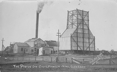 El Dorado Museum Association Inc.
Photograph (item) - Digital Image
Cocks Pioneer Mine El Dorado, Power Station No. 2 was established in 1914 and located near junction of Reid's and Clear Creeks, Byawatha. Cocks Pioneer Electric Gold & Tin Mine Company was formed in 1899. The company's first power station, located at the eastern end of the valley began operating with its 340 Kilowatt steam-powered generator. By 1909, from 2,500,000 cubic yards worked, reported recovery was 17,284 ounces of gold and 224 tons of tin ore. By 1909, Cocks Pioneer’s power plant had become inadequate and uneconomical. The barge was floated downstream about a mile, but lost time caused the operations to cease. Following testing, a new mine was established by diverting Reid's Creek at a cost of £25,000. Settling dams were built, one of which held 1,935,900 cubic feet. Sold earth banks, built against a wall of stringy bark saplings constructed and laced with vertical props, were built. In 1914, the company was reformed as Cock’s Pioneer Gold and Tin Mines NL, another power station was constructed at the western end of the township, near the junction of Clear and Reid's Creeks. From 6,800,000 cubic yards of material processed, the returns were 64,397 ounces of gold and 855 ton of tin. Cocks Pioneer mine then moved the barge downs stream and continued sluicing. In 1929 Cocks Pioneer Electric Gold and Tin Mining Company ceased operations due to a drop in values. Cock’s Pioneer Gold and Tin Mines NL carried on large-scale hydraulic sluicing operations until 1941. Handwritten on front: 'THE POWER STN COCKS, PIONEER MINE, ELDORADO' / 'THELMA STUDIO / [underlined] WANGARATTA'mining, gold, tin, cocks pioneer, power, sluicing, el dorado, eldorado, byawatha, thelma studios, wangaratta, gold mining, tin mining, reid's creek, clear creek -
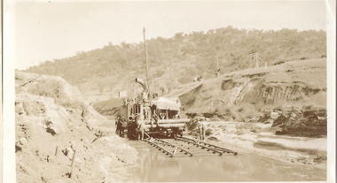 El Dorado Museum Association Inc.
Photograph (item) - Digital Image
Cocks Pioneer Creek Diversion. Cocks Pioneer Electric Gold & Tin Mine Company was formed in 1899. The company's first power station, located at the eastern end of the valley began operating with its 340 Kilowatt steam-powered generator. By 1909, from 2,500,000 cubic yards worked, reported recovery was 17,284 ounces of gold and 224 tons of tin ore. By 1909, Cocks Pioneer’s power plant had become inadequate and uneconomical. The barge was floated downstream about a mile, but lost time caused the operations to cease. Following testing, a new mine was established by diverting Reid's Creek at a cost of £25,000. Settling dams were built, one of which held 1,935,900 cubic feet. Sold earth banks, built against a wall of stringy bark saplings constructed and laced with vertical props, were built. In 1914, the company was reformed as Cock’s Pioneer Gold and Tin Mines NL, another power station was constructed at the western end of the township, near the junction of Clear and Reid's Creeks. From 6,800,000 cubic yards of material processed, the returns were 64,397 ounces of gold and 855 ton of tin. Cocks Pioneer mine then moved the barge downs stream and continued sluicing. In 1929 Cocks Pioneer Electric Gold and Tin Mining Company ceased operations due to a drop in values. Cock’s Pioneer Gold and Tin Mines NL carried on large-scale hydraulic sluicing operations until 1941. mining, gold, tin, cocks pioneer, creek, gold mining, tin mining, el dorado, eldorado