Showing 123675 items matching "main-road"
-
 Victorian Maritime Centre
Luggage Tag
The souvenir brass & leather luggage strap was purchased sometime during a cruise by an unknown person. It is part of a cruise liner collection by D. Benson and Family over a period of years. D. Benson sold part of the collection to the V.M.C who purchased the remaining part. It is a great source of information to visitors to the V.M.C. At the time of ocean liner holiday cruising, many people purchased these souvenirs to keep or give away as gifts.Brass luggage tag on leather strap with 'Fairstar''& emblem engraved on front. Name & address of passenger engraved on rear.On back, D. Benson, 61 Campbell Road, Somers. One front Fairstar.fairstar, souvenir -
 Rutherglen Historical Society
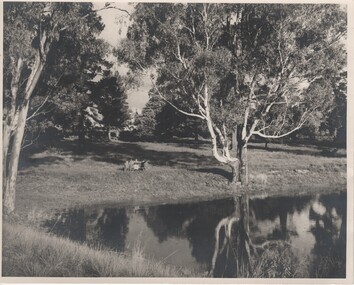
Image, Robert B Billings, c1953
Photograph of the Billings children at a picnic table at the side of Lake King.Black and white photograph of park with trees reflected on the surface of a lake. Several children are seated at a picnic table.Written on back of photo: "Rutherglen Lake. About 1953. (Stopped at [Browning?] Road)billings family, lake king, rutherglen park -
 Brimbank City Council
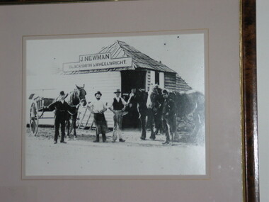
Black and White Photograph, J. Newman - Blacksmith
Local historical scenehistoric local area- J. Newman - BlacksmithBlack and white photographPlaque on front bottom left of frame. "J. Newman, Ballarat Road and date". -
 Mt Dandenong & District Historical Society Inc.
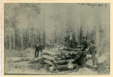
Photograph, Olinda Rifle Range 1903
Scene showing 12 men at the Olinda Rifle Range in 1903. One man firing rifle. Reverse of photograph has handwritten description by John Lundy-Clarke.The Rifle Range at Olinda 1903. Was in the area of the Rhododendron Gardens by Georgian Road and the GolfLinks.olinda, rifle range -
 Hawthorn Historical Society
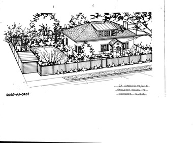
Drawing - Property Illustration, 2A Currajong Street, Hawthorn East
'After training as a Cartographic Draftsman within the mining industry, I worked as a property illustrator for real estate firms in the eastern suburbs of Melbourne for 23 years from 1983. I initially photographed houses with a Polaroid camera and made a 'thumbnail' sketch while there. The photos were used to scale off a sketch in pencil and then that sketch was overlaid with drafting film and the 'pen and ink' completed. The pens I used were the Rotring ‘Rapidigraph’ drafting pens. The ink was also made by Rotring (German).The film was ‘Rapidraw’, polyester drafting film, double matte. It takes a very fine line and doesn’t bleed. As well as house sketches, there were often floor plans and site plans ordered. Aerial sketches were ordered when the property needed an overall view.' (Margaret Picken, 2020)This property illustration is one of a series created by Margaret Picken for a range of real estate agents in Melbourne between c. 1983 and c. 2006. Each work is signed and dated by the artist.Gift of Margaret Picken, 2020Pen and ink property illustration on drafting film of 2A Currajong Street, Hawthorn East by Margaret Picken.2A Currajong Road, Haw E, Margaret Picken '98. Woodards - Hawthorn.artist - margaret picken 1950- -
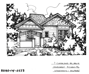 Hawthorn Historical Society
Drawing - Property Illustration, 7 Currajong Street, Hawthorn East
'After training as a Cartographic Draftsman within the mining industry, I worked as a property illustrator for real estate firms in the eastern suburbs of Melbourne for 23 years from 1983. I initially photographed houses with a Polaroid camera and made a 'thumbnail' sketch while there. The photos were used to scale off a sketch in pencil and then that sketch was overlaid with drafting film and the 'pen and ink' completed. The pens I used were the Rotring ‘Rapidigraph’ drafting pens. The ink was also made by Rotring (German).The film was ‘Rapidraw’, polyester drafting film, double matte. It takes a very fine line and doesn’t bleed. As well as house sketches, there were often floor plans and site plans ordered. Aerial sketches were ordered when the property needed an overall view.' (Margaret Picken, 2020)This property illustration is one of a series created by Margaret Picken for a range of real estate agents in Melbourne between c. 1983 and c. 2006. Each work is signed and dated by the artist.Gift of Margaret Picken, 2020Pen and ink property illustration on drafting film of 7 Currajong Street, Hawthorn East by Margaret Picken.7 Currajong Road, Haw E, Margaret Picken '96. Woodards - Hawthorn.artist - margaret picken 1950- -
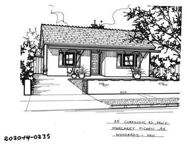 Hawthorn Historical Society
Drawing - Property Illustration, 35 Currajong Street, Hawthorn East
'After training as a Cartographic Draftsman within the mining industry, I worked as a property illustrator for real estate firms in the eastern suburbs of Melbourne for 23 years from 1983. I initially photographed houses with a Polaroid camera and made a 'thumbnail' sketch while there. The photos were used to scale off a sketch in pencil and then that sketch was overlaid with drafting film and the 'pen and ink' completed. The pens I used were the Rotring ‘Rapidigraph’ drafting pens. The ink was also made by Rotring (German).The film was ‘Rapidraw’, polyester drafting film, double matte. It takes a very fine line and doesn’t bleed. As well as house sketches, there were often floor plans and site plans ordered. Aerial sketches were ordered when the property needed an overall view.' (Margaret Picken, 2020)This property illustration is one of a series created by Margaret Picken for a range of real estate agents in Melbourne between c. 1983 and c. 2006. Each work is signed and dated by the artist.Gift of Margaret Picken, 2020Pen and ink property illustration on drafting film of 35 Currajong Street, Hawthorn East by Margaret Picken.35 Currajong Road, Haw E, Margaret Picken '94. Woodards - Haw.artist - margaret picken 1950- -
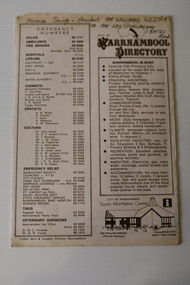 Warrnambool and District Historical Society Inc.
Pamphlet - Warrnambool Directories, Warrnambool City Council (Warrnambool Tourist Information Centre), Warrnambool Directory. Welcome to Warrnambool, Warrnambool and District Directory, 1970s and 80s
Warrnambool Directories.1 and .2 One sheet of paper folded twice to provide six pages. The pages contain a map and printed material. .3 One sheet pf paper folded to provide sixteen pages. The pages contain two maps and printed material. The front page has a stamp indicating the original owner. non-fictionWarrnambool Directorieswarrnambool tourism, shipwreck coast tourism -
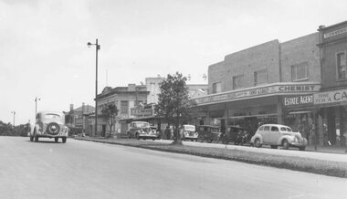 Ringwood and District Historical Society
Photograph, Maroondah Highway Central, Ringwood. Looking west from near Adelaide Street, c1948
Black and white photograph (2 copies)Image shows shops on north side of Whitehorse Road towards Town Hall. -
 Bendigo Historical Society Inc.
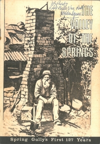
Document - PURDY COLLECTION: VALLEY OF THE SPRINGS
Booklet: 'The Valley of the Springs' a booklet produced to celebrate Spring Gully's First 127 Years. Contains poem about Spring Gully by J.C. Hattam, Photos: St. Phillips Spring Gully, choir practice; garden party to raise funds for St. Phillips, taken on Keck's verandah, Abbotts Tannery, Tannery Lane, school photos, opening of tower on One Tree Hill, a mine at Diamond Hill (un-named) horse drawn vehicles, wood carter, Spring Gully reservoir being enlarged. Written on front in biro 'J.B. Purdy, 49 Bellevue Road, Golden Square. bendigo, history, spring gully -
 Bendigo Historical Society Inc.
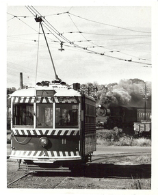
Photograph - BASIL MILLER COLLECTION: TRAM - BENDIGO TRAMWAYS, unknown
BHS CollectionNo. 11 tram departing North Bendigo terminus, steam train on railway line on right hand side of tram with steam issuing forth, following carriages barely visible. 'Bendigo' destination sign on tram. Mining chimney visible on left hand side behind tram.Claver P. Carroll, 79 Eaglehawk Road, Eaglehawk, Victoria. Tr - 20basil miller, bendigo tramways, north bendigo, steam train, claver carroll -
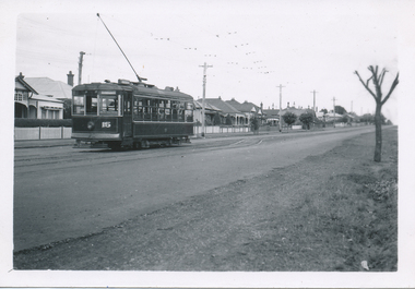
 Melbourne Tram Museum
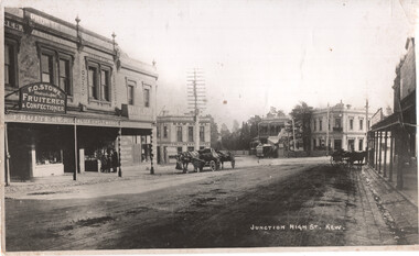
Photograph - Kew Junction looking South West - horse tram, c1900
Photograph, from a postcard titled "Junction High St Kew." shows a horse tram at Kew Junction in Church St about to turn into High St. Buildings in the view are F O Stowe Fruiter Confectioner, Alice cycle works, a tobacconist advertising Havelock tobacco sign, and Collins Kew Hotel. There are three horse-drawn carts, one with a horse eating from a chaff bag.Yields information about Kew Junction c1900.Black and white photograph with notes on the rear.Has on the rear in pencil "Horse tram in Barker Road Kew" and number "185"tramways, horse trams, kew junction, high st kew, church st -
 Ringwood and District Historical Society
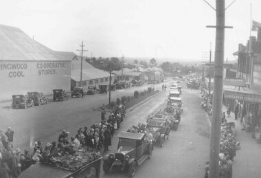
Photograph, Melba's funeral, February 1931 passing through Ringwood
Black and white photograph (2 copies)Image shows a cavalcade of vehicles in Whitehorse Road going past the Cool Stores. -
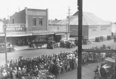 Ringwood and District Historical Society
Photograph, Melba's funeral, February 1931 passing through Ringwood
Black and white photograph (2 copies)Image shows a large crowd of spectators in Whitehorse Road watching the funeral procession. -
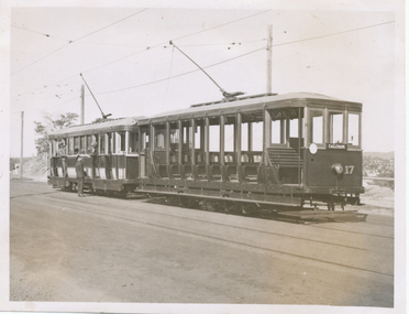 Ballarat Tramway Museum
Photograph - Black & White Photograph/s, Wal Jack, Easter Saturday, 1941
Black and White print contained within the Wal Jack Bendigo and Geelong Album, see Reg Item 5003 for more details. No. 17 and No. 22 at Mt Korong Road loop - Garden Gully Loop. Photo taken Easter Saturday, 1941. Negative No. T191. No. 17 has the destination of "Eaglehawk" and is carrying a white disk at the front of the tram. i1 - scan of print in the album i2 - rear of image i3 - scan of negative at 3200dpi added 6/6/2020. On rear in ink "T191 State Electricity Commission Bendigo tramways / No. 17 summer car and "No. 22 Ex MMTB G Class standing at Passing Loop in Mt Korong Road, Easter Saturday 1941." In bottom right hand corner "W. Jack Photo".trams, tramways, bendigo, mt korong road, garden gully loop, tram 17, tram 22 -
 Ballarat Tramway Museum
Photograph - Black & White Photograph/s, Wal Jack, 3/01/1945 12:00:00 AM
Black and White print contained within the Wal Jack Bendigo and Geelong Album, see Reg Item 5003 for more details. Photo of Geelong No. 15 in Ryrie St near Normanby Road stop, car from Eastern Park 3rd January 1945. Photo by Wal Jack. Note tram has the destination of Eastern Park. i1 - scan of print in the album i2 - rear of image i3 - scan of negative at 3200dpi added 27/6/2020. On rear in ink "SEC Geelong No. 15 Birney car in Ryrie St near Normanby Road stop, car from Eastern Park 3rd January 1945" Has the Wal Jack copyright stamp in the top right hand corner with the number "T317" written in.trams, tramways, geelong, ryrie st, eastern park, tram 15 -
 Greensborough Historical Society
Photograph - Digital image, Frank Solomon, Greensborough: Mural on Vickers Way, 04/06/2010
Main Street Greensborough. Mural on Vickers Way (lane between Main Street and carpark near old pool). The mural was demolished as part of the redevelopment on Main Street.Digital copy of colour photographmain street greensborough, vickers way -
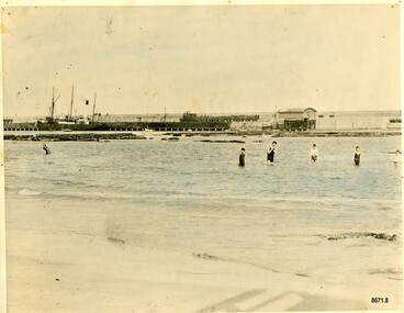 Flagstaff Hill Maritime Museum and Village
Photograph - Vessel S. S. Casino in Lady Bay Warrnambool, 1920's - 1930's
This photograph was one of ten photographs donated to Flagstaff Hill Maritime Museum and Village by Fred Trewartha. Frederick John Fox Trewartha (Fred) was a well-known Warrnambool businessman. He was born in Beeac near Geelong in 1920 and came to Warrnambool with his family as a very young child. He was apprenticed to his father John, as a saddler and later opened his own shop on Raglan Parade. He then moved into working with tarpaulins and canvases for the trucking industry. Fred was keenly interested in photography (and was a member of the Warrnambool Cine Club), yachting and boat building. He kept his yacht moored at Port Fairy for many years and participated in sailing events locally and interstate. He also built boats with his sons. He had the opportunity to meet many older sailors and it's thought this photo (and others in the set) may have been given to him by one of these men. Fred Trewartha died in 2016 in Warrnambool. Warrnambool by the 1920's and 1930's had become a popular holiday destination with visitors arriving by steamer and train. It was during these decades that a "Surf Bathers Association" began in Warrnambool in response to the growing popularity of local sea bathing. They worked with the local council to develop a "Beach Improvement Fund" and a comprehensive plan of "Beach Improvement" which included erecting and maintaining beach boxes, building a kiosk, improving paths and roads to the beach, planting marram grass on the sand dunes, building new enclosures for vehicles and horses and generally making the beach more attractive for visitors and townspeople. The 1930's was also an era when free "Herald" Learn-to-Swim classes were being held throughout Victoria. In 1931 it was reported in "The Age" newspaper that "over the past week in Warrnambool, 250 pupils had passed through the hands of the local life saving club swimming instructors". The Port of Warrnambool - In the early years the Port of Warrnambool was a busy port. Steamships and sailing ships were frequent visitors to the port. Steam navigation companies were plentiful, carrying passengers and freighting cargo such as coal, timber, food, livestock, furniture, hardware and haberdashery between Melbourne and the ports along the southwest coast of Victoria, including Warrnambool. The carts would take their loads into the township for distribution. The Breakwater was built (using 32 ton blocks of concrete) between 1874 and 1890 to provide ships with greater protection from the Southern Ocean. The Lifeboat and Rocket House - The coastline of South West Victoria has had over 600 shipwrecks and many lost lives; even in Warrnambool’s Lady Bay there were around 16 known shipwrecks between 1850 and 1905, with eight lives lost. In 1859 the first Government-built lifeboat arrived at Warrnambool Harbour and a shed was soon built to house it, followed in 1864 by a rocket house to safely store the Rocket Rescue equipment. In 1878 the buildings were moved to the Breakwater area, and in 1910 the new Lifeboat Warrnambool arrived with its ‘self-righting’ design. For almost one hundred years the lifeboat and rocket crews, mostly local volunteers, trained regularly to maintain and improve their skills, summoned when needed by alarms, gunshots, ringing bells and foghorns. Some became local heroes but all served an important role. By the end of the 1950s the lifeboat and rescue equipment had become obsolete. The S.S. Casino was a passenger and freight steamer built in Dundee, Scotland, in 1882 for the Newcastle and Hunter River Steam Navigation Company of N.S.W. She weighed 425 tons gross with a length of 160.4 feet, beam of 24.1 feet and a depth of 10.2 feet. She had saloon accommodation for 35 people, a fore cabin for 25 more people, and she carried 300 tons of cargo. While on her delivery journey on May 30th 1882, the S.S. Casino called in at the Port of Warrnambool for coal, narrowly escaping going ashore in gale force winds due to the quick action of the pilot. At that time, still at anchor, she impressed the directors of the Belfast and Koroit Steam Navigation Company so much that they bought her immediately; she was ideal for trade along the West Coast of Victoria. (The Belfast and Koroit Steam Navigation Company was first managed by Messers. Saltau and Osburne and after the passing of Mr. Osburne, by produce merchants Messers H. Sautau and Sons, who had a hay and corn store and shipping agency on the corner of Liebig and Koroit Streets in Warrnambool. ) The S.S. Casino became “the most famous steamer to operate in Victorian waters along the West Coast” by author Jack Loney. Captain Boyd was her first Master, followed by Captain Chapman, who stayed with her from 1890 until 1924. Captain W. Robertson followed for a short term, and then Captain Middleton then took command from 1925 - 1932. An article published on Monday 11th June 1932 in The Sun News Pictorial (Melbourne) giving a detailed history of S. S. Casino said "owned by Port Fairy interests, she was an integral part of the town's development ... for a long time, her arrival in Port Fairy was an event, the townspeople going down to the wharf to see her come in". It also said "Except when the weather was bad, the Casino hugged the coast on her trips and passengers obtained wonderful views of the sandstone terraces and caves. A little time ago every member of her regular crew except one, was a Scotsman." The S.S. Casino had several mishaps during her life. One was on 3rd January 1898 when she collided with the S.S. Flinders in Apollo Bay with minor damage. Another was on 24th October 1924 when she grounded on a reef at Point Hawdon near Grey River and most of her cargo (of Christmas goods) had to be dumped into the sea. Then in February 1929 she was ‘holed’ when she struck a submerged object as she entered Lady Bay, Warrnambool. In the years following the turn of the century, the S.S. Casino remained the only regular trader with normal passenger accommodation along the West Coast. From 1882 she had made at least 2,500 voyages on the one run. On the morning of 10th July 1932, after attempting to berth at Apollo Bay jetty in heavy seas, Captain Middleton decided to take her out into the bay and wait until the seas abated. It was not realised that the anchor used to steady her as she manoeuvred to her berth had pierced her hull. She put about and headed for the beach but sank. Captain Middleton and nine others lost their lives; nine people were rescued including the two female passengers. Captain Middleton had been in charge of the S.S. Casino for seven years. He was the first ship’s Master to lose his life in a shipwreck in the West Coast trade. In June 1932, the directors of the Belfast and Koroit Steam Navigation Company had proposed to celebrate the completion of fifty years of trading by the steamer Casino in August, but tragically the Casino was wrecked only one month later (and "was only one month off completing its fifty years of valuable service between Melbourne and Portland.") Flagstaff Hill’s collection has a photograph of a portrait of Captain Chapman, a ship model of the S.S. Casino that shows both forms of power under which she sailed, steam and sail. The ship is painted green and flies three flags. The inscription across the case of the ship model, incorrectly dated, tells the sad story of the wreck of the ship and the loss of lives on July 10th 1932 at Apollo Bay. A print in the Collection shows S.S. Casino underway in the heavy sea off Point Lonsdale, another two photographs show her at the Port of Warrnambool, leaving from the Breakwater in Lady Bay and another identifies the S.S. Casino as a ship from the Belfast and Koroit Steam Navigation Company. (Belfast is the original name for the township of Port Fairy).This photograph is significant because of its association with the coastal trader S.S. Casino and its significance to trade along Victoria's West Coast in the late 19th and early 20th centuries. The wreck of the S.S. Casino is considered an important part of Victorian and Australian cultural heritage and as such has been declared and protected as an Historic Shipwreck under State and Commonwealth Law in the Commonwealth Historic Shipwrecks Act (1976). It is also significant as it shows the early years of tourism in Warrnambool and the important role the beach played in the lives of residents and visitors.A black and white photograph (with colour tinting) showing Lady Bay in Warrnambool with the Breakwater in the background. The S. S. Casino is moored at the Breakwater and the lifeboat shed and a coal train can be seen on the Breakwater. Six swimmers are standing in the water. On the back of the photograph are the donor's name and telephone number (written in black biro) and the name of the S. S. Casino and its tonnage written in blue ink. A blurred number has been stamped on plus a "M' written in pencil.Donor's name, address and phone number / "S. S. Casino" / "500 TONS" / "REG" "- - - 09 " (blurred numbers) / "M"warrnambool, great ocean road, shipwreck coast, lady bay, breakwater, fred trewartha, frederick john fox trewartha, surf bathers association, sea bathing, swimming, warrnambool beach, beach improvement fund, port of warrnambool, steamships, lifeboat house, rocket house, lifeboat crew, s. s. casino, belfast and koroit steam navigation company, saltau and osburne, captain middleton, apollo bay, apollo bay shipwreck -
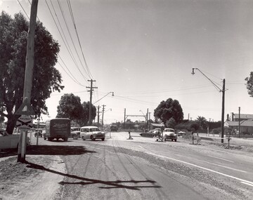 City of Kingston
Photograph - Black and white
This photograph depicts the road diversion on Nepean Highway that was implemented to allow construction of the railway line underneath the Nepean Highway at Moorabbin. An "Allourie" Cheese, Honey Canned Ham van is prominent on the left of the image, the railway gates are central and the old Moorabbin Station is visble. Beyond the dates, pedestrians are visible crossing the Nepean Highway. This image is part of a larger collection of images from the Public Transport Corporation displaying train stations and streetscapes in what is now the City of Kingston.In 1958 excavations began for the removal of the level crossing gates at the southern end of the Moorabbin shopping centre on Nepean Highway. The station was also lowered below ground. A diversion route was created to enable the flow of traffic in both directions along the highway.Black and white photograph of road diversion on Nepean Highway, Moorabbin to allow the construction of the railway line below the Nepean Highway at Moorabbin and also to trench the station. This image is part of a larger collection of images from the Public Transport Corporation displaying train stations and streetscapes in what is now the City of Kingston.White adhesive dot sticker: Printed black 199 Handwritten in red ink: 80% Handwritten in black ink on yellow Post-It Note: [indecipherable] 199 - Diversion for Crossing Stamped in blue ink: COPYRIGHT Public Transport Corporation, For reordering photographs, Please quote negative No m 5687, Enquiries C/- PTC Photographic Unit, Telephone switchboard 619 1111railway crossing, railway station, city of moorabbin -
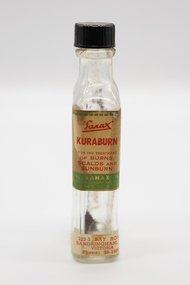 Glen Eira City Council History and Heritage Collection
Kuraburn bottle
This Kuraburn Bottle is part of a Sanax First Aid Case which was used at the the former Carnegie Senior Citizens' Centre. The centre was located at 314 Neerim Road, Carnegie. When the Neerim Road facility closed, its activities were moved to the Carnegie Library and Community Centre. For Occupational Health and Safety reasons, Council no longer maintains first aid kits at senior citizens' centres. Clear glass bottle with two paper labels on narrow side. One red, green, white and black label with Sanax branding, one red and white label at base of bottle with address and contact details. Black plastic screw-top lid with a section missing. Bottle has been decanted however some residue remains. Small cork stopper contained within bottle."Sanax" KURABURN / FOR THE TREATMENT / OF BURNS / SCALDS AND / SUNBURN / THE SANAX CO. / 849-51 NEPEAN HIGHWAY / MOORABIN / TEL XU 2651 / Left side of label: Directions: Dab on lightly, and repeat in two hours if necessary. Applied early, it prevents blistering. Right side of label: Allow to dry on the skin before putting on wearing apparel, to avoid staining the clothes. 223-5 BAY ROAD, / SANDRINGHAM, S.8 / VICTORIA / Phone: 98-1604 -
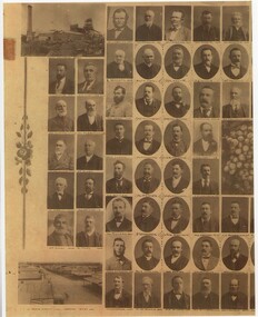 Rutherglen Historical Society
Image, c1880-1890
Copy of a photograph of early pioneers of Rutherglen. Copy has been made in two sections. The original featured a bunch of grapes in the centre with individual photographs, grouped about the centre. Photographs of each individual are identified with their name below the image. Photos of local landmarks are at each corner: top left - Great Southern Mine, top right - Town Hall, bottom left - Main Street-Looking West, bottom right - Main Street-Looking East.rutherglen, rutherglen pioneers -
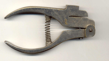 Ballarat Tramway Museum
Functional Object - Ticket punch
Demonstrates aspects of tramway operation, cancelling or showing that tickets had been inspected following sales to passengers by the conductor or motorman. Traditionally used by tramway operators to check or cancel tickets.Brass cast body with steel pins and screws, chrome plated, machined, device used to cancel or punch paper tickets when purchased or inspected. Placed a round hole in the ticket. Spring loaded, consists of two main parts with a pin, screws & spring in addition. . Chrome plate in good condition. The initials "ECV" have been cast in to the body of the main component. A relatively heavy unit compared to others, does not appear to have had a lot of use.trams, tramways, ticket punch, tickets, fares -
 Falls Creek Historical Society
Poster - Kangaroo Hoppet 2016
The Kangaroo Hoppet is Australia’s premier long distance cross country ski race, and a member of the Worldloppet series of international cross country ski events. The first race at Falls Creek was held in 1979 under the name of “Australian Birkebeiner”. It was a 21km race with about 80 participants organised by the Birkebeiner Nordic Ski Club of Mount Beauty. The course started and finished at Falls Creek Alpine Resort and took participants out into the Bogong High Plains. After running the event for 10 years, it was decided they should become part of the Worldloppet series of marathon ski races. Representatives from the Birkebeiner Nordic Ski Club and the Australian Ski Federation attended the Worldloppet Annual Meeting in Finland in June 1990 to put the case for the acceptance of an Australian event into the Worldloppet series. Before being admitted, they had to demonstrate that the Birkebeiner Club could run a world class event, so three months later in August 1990 a 42km event named the Australian International Ski Marathon was held at Falls Creek together with a 21km Birkebeiner race and a 7km event called the Birkebeiner Lite. The event was approved by delegates from USA, Norway and Austria, in 1991 Australia became the 12th member of Worldloppet, with the condition that there had to be a name change. After some late night discussion allegedly involving red wine from North East Victoria the main event became the 42km Kangaroo Hoppet, with the minor events being the 21km Australian Birkebeiner, and 7km Joey Hoppet. In the winter of 1991, the first Kangaroo Hoppet was held. It was a great success and has been a regular fixture on the international ski calendar ever since. It features the main 42km event as well as a 21km event and a 7km event. The Hoppet brings the Australian snowfields to an international audience. In 2016 the Men's Winner was Matthew Gelso from USA in a time of 1:53:23.1. The winner of the Women's event was Deedra Irwin of USA in a time of 2:08:15.6. This poster is significant because it documents an event which brings international attention to Falls Creek and the surrounding region.A poster featuring two skiers crossing gentle slopes passing a tree on the right. There is a line of international flags flying overhead and the outline of two kangaroos in the distance. Logos of Worldloppet, AGL, Falls Creek, Alpine Shire Council, Victorian State Government, the Birkebeiner Nordic Ski Club and FIS are across the bottom of the poster.Beside Kangaroo Hoppet yellow and black Road sign: KANGAROO HOPPET 26 27 August 2016 42 km 21 km 7 km Falls Creek Victoria Australia Below the logos: www.hoppet.com.au kangaroo hoppet, worldloppet events, falls creek, mt. beauty -
 Kew Historical Society Inc
Plan - Subdivision Plan, Houghton Street & Buchanan Avenue, Balwyn North, ca. 1906
The Kew Historical Society collection includes almost 100 subdivision plans pertaining to suburbs of the City of Melbourne. Most of these are of Kew, Kew East or Studley Park, although a smaller number are plans of Camberwell, Deepdene, Balwyn and Hawthorn. It is believed that the majority of the plans were gifted to the Society by persons connected with the real estate firm - J. R. Mathers and McMillan, 136 Cotham Road, Kew. The Plans in the collection are rarely in pristine form, being working plans on which the agent would write notes and record lots sold and the prices of these. The subdivision plans are historically significant examples of the growth of urban Melbourne from the beginning of the 20th Century up until the 1980s. A number of the plans are double-sided and often include a photograph on the reverse. A number of the latter are by noted photographers such as J.E. Barnes.A hand-drawn subdivision plan listing six blocks bounded by Houghton Street, Doncaster Road, Buchanan Avenue and Maud Street, North Balwyn. Written on the plan of subdivision are the lot numbers, the dimensions of the blocks and the price at which two lots were for sale or had been sold for.subdivision plans - balwyn -
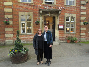 Ballarat Heritage Services
Photograph - Digital photograph, Wayne Phillipson, Peta Knott and Dorothy Wickham at Lacock National Trust Village, United Kingdom, 30/1072016
Lacock was on the main London to Bristol road until the road was re-routed through Chippenham. There are no obvious signs of the 21st century in this National Trust village, except the motor car. It has been run by the National Trust since 1944 and residents are on a lease. The oldest house in the village is King John's Hunting Lodge, parts of which date back to the 13th century. In this village there are buildings from every century since right up until the 18th century. The abbey was founded in 1229 by Ela, Countess of Salisbury. Lacock village and abbey were used as the set in the Harry Potter films.Dorothy Wickham and Peta Knott, formerly of Museums Australia (Vic) currently working as a marine archaeologist in England. Taken at Lacock National Trust Village, United Kingdomdorothy wickham, peta knott, lacock national trust village -
![Wal Ives & Bert [Watson] at the outlet of the Kew Main Drain](/media/collectors/550653872162f11fb04854aa/items/61593ef27608a87f688412b1/item-media/61594a5a7608a87f68848c29/item-fit-380x285.jpg) Kew Historical Society Inc
Kew Historical Society IncPhotograph - Wal Ives & Bert [Watson] at the outlet of the Kew Main Drain, c.1900
Connor's Creek is/was one of two major waterways bisecting Kew, both of which empty into the Yarra River. Connor's Creek originates near the grounds of Genazzano FCJ College, which is one of the highest points in Kew. Until the 1930s, this was an open creek until a barrel drain - the Kew Main Drain - was constructed. As the creek ran through Kew it cut across a number of roads the maintenance of which was a continuing concern for Kew Councillors. In August 1864, the Council called for tenders to erect a stone culvert and embankment over Connor's Creek, on Belford-road. This may be the embankment on which the boys are sitting.Original, small photographic positive on card of two boys, identified by the donor as 'Wal Ives and Bert' [Albert Watson] sitting on bluestone capping above an outlet of Connor's Creek. To the left of the boys is a barrel drain which at that stage was the outlet for Connor's Creek near the Yarra River. The retaining wall is constructed of brick. In ink on photo: "Wal & Bert"connors creek -- kew (vic), wal ives, albert watson, belford road, yarra river -- kew (vic.), creeks -- kew (vic.), drains -- kew (vic.) -
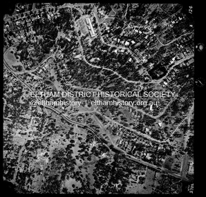 Eltham District Historical Society Inc
Photograph - Aerial Photograph, Landata, Montmorency / Lower Plenty, Jan. 1973
Centred on 385 Main Road, Lower Plenty bounded by Grand Boulevard, Montmorency to north, Old Eltham Road to south, Bolton Street to east and Panorama Avenue to west. Historic Aerial Imagery Source: Landata.vic.gov.au Aerial Photo Details: Project No :1043 Project : MONTMORENCY Run : 2 Frame : 124 Date : 01/1973 Film Type : B/W Camera : RC8 Flying Height : 2200 Scale : 4000 Film Number : 2722 GDA2020 : 37°43'48"S, 145°07'49"E MGA2020 : 335243, 5822507 (55) Melways : 21 E9 (ed. 42)aerial photo, lower plenty, main road, montmorency, phoebe mason collection, bolton steet, grand boulevard, old eltham road, panorama avenue -
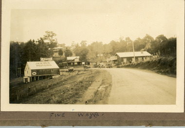 Mt Dandenong & District Historical Society Inc.
Photograph
The image is from the album of Ivy Child and depicts the Five Ways intersection at Kalorama. Jeeves Motors, run by Hubert Jeeves is on the left hand side. The General Store that became a bank and now a gallery is to the right. The FiveWays Cafe is in the centre with the Mountjoy Guesthouse behind it. The photo would be from the late 1920s. Ivy May Child (1910 – 1989) was the daughter of Arthur Edward (Ted) Child (1878 – 1964) and Ethel May Madden (1888 – 1970). Ted Child was the son of Matthew Francis Child (1839 – 1933) and Martha Jeeves (1857 – 1926). He was the grandson of one of the early pioneers Francis Child. Ivy grew up on the family property on Childs Road and took many photographs. Most of these are glued into her photo album. The album covered the years from c1927 – 1932. Ivy married Henry William Burgess (1906 – 1968) in 1944. The photographs remain in their original state in the album with individual copies made. Sepia coloured photograph with a road in the foreground leading up to an intersection with buildinga on three corners. A large building visible on hillside behind. Six old cars are parked around the intersection. Bush is behind the photo.Written below image in album: FIVE WAYSjeeves motors, hubert jeeves, mountjoy, guesthouse, general store, fiveways cafe, fiveways, five ways, kalorama, cars, bank -
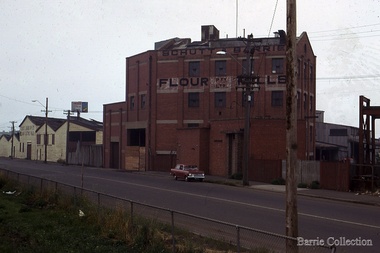 Melton City Libraries
Photograph, Schutt and Barrie Flour Mills, 1969
Arthur Henry Schutt. Born 18th July 1912 at Spotswood He was the third child of John Ralph and Mary Jane Schutt. His grandfather was the first librarian of the Victorian Law Courts and his uncle, William Schutt, was a lawyer who later became the Chief Justice Sir William Schutt. His mother was born a Clutha House, stony Creek Yarraville, a was one of ten children. John Schutt opened a chaff mill at the corner of Williamstown and Geelong Roads at West Footscray. The mill was placed on in an old quarry below the ground which saved much of the backbreaking labour of heaving sheaves of hay up into the machinery, the below ground location enable the hay to be fed directly into the railway trucks into the cutters. An elevator then carried the chaff up from the ground directly into the waiting transport, at a great saving in manpower. The chaff mill became on of the largest in Victoria employing more than forty men, and later moved into flour milling.Schutt and Barrie Flour Mills, Melton South site. Opposite this Mill was a Public Weighbridge. A rail siding crossed Brooklyn road to serve chaff mill. The rail line crossed west of the Methodist Churchlocal identities, agriculture