Showing 64455 items
matching henderson-house
-
 Bendigo Historical Society Inc.
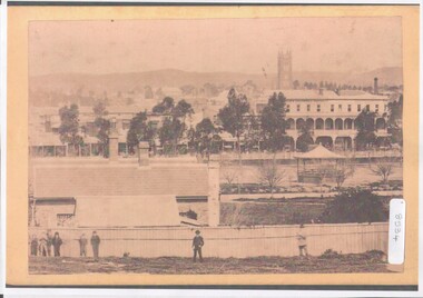
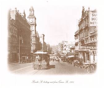
Photograph - Pall Mall shops
BHS CollectionA4 copy of original photograph. Pall Mall shops viewed from Government Camp, prior to 1870 (when Post Office and Court House were erected). View shows the Shamrock Hotel and the Royal Exchange Hotel with linked verandahs, the bell tower of St Paul's Anglican Church; and band stand (on the site of Post Office) beyond the creek. In the foreground part of the Government Offices with eight men shown on fence line.bendigo buildings, early buildings in bendigo late 1800s -
 Kew Historical Society Inc
Photograph - Yarra in Flood from Willsmere, North Kew, 1923
Flooding of the Yarra Valley, including that section of the Yarra bordering Kew and Kew East in the north and west of the municipality, was a regular occurrence. Extreme flood events of the Yarra River are recorded to have occurred in 1891, 1901, 1916, 1923 and 1934. The Municipality of Kew's response to these floods was to enact planning decisions restricting residential development in flood prone areas following the floods of 1916, 1921 and 1934. While floods continued after the development of the Upper Yarra Reservoir (construction 1948-57), the regularity and extent of these inundations diminished. Original, large sepia photograph showing men, women and children who have gathered on a grassy verge, probably farm land, to look out across the flooded Yarra Valley at Willsmere, North Kew. In the medium distance are three houses that are largely submerged by the flood waters as well as a number of Eucalypts. Judging by the clothes of the spectators, the date might be 1901 or 1916, but probably the latter due to the hats worn by a number of the women. Inscribed reverse: "Gift of Kerrie Woollard (KCC) (P)C.1923yarra river valley, kew east (vic.), floods, willsmere -
 Kew Historical Society Inc
Plan - Subdivision Plan, Lodged Plan No.6518, 1920-1940
The Kew Historical Society collection includes almost 100 subdivision plans pertaining to suburbs of the City of Melbourne. Most of these are of Kew, Kew East or Studley Park, although a smaller number are plans of Camberwell, Deepdene, Balwyn and Hawthorn. It is believed that the majority of the plans were gifted to the Society by persons connected with the real estate firm - J. R. Mathers and McMillan, 136 Cotham Road, Kew. The Plans in the collection are rarely in pristine form, being working plans on which the agent would write notes and record lots sold and the prices of these. The subdivision plans are historically significant examples of the growth of urban Melbourne from the beginning of the 20th Century up until the 1980s. A number of the plans are double-sided and often include a photograph on the reverse. Reconciling this hand-drawn subdivision plan with a modern map of the area is initially a challenge due to a change of street names. Argyle Road in the centre of the subdivision was to be renamed Deepdene Road, and the street named Deepdene Road on the plan was to become Deepdene Place. Of interest is the nursery on the corner of Argyle and Whitehorse Roads. During this period there were a number of nurseries servicing the Kew and Balwyn areas. The subdivision was essentially of the land formerly occupied by the house 'Deepdene'.subdivision plans - balwyn, deepdene, whitehorse road -- deepdene (vic.), deepdene road -- deepdene (vic.), burke road -- deepdene (vic.) -
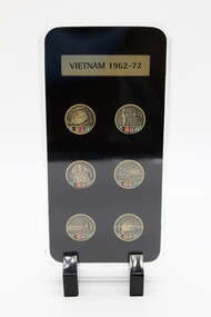 Diamond Valley Vietnam Veterans Sub-Branch
Memorabilia - Pin Collection, 18/8/2016
The presentation case was produced as a Welfare Fundraising item and could be displayed on shelf or the like; the pins are a very simple depiction of the Australian Armed Services in the Vietnam war. A small but relevant reminder of the range of Australian Armed Services in Vietnam during period 1962 - 1972.The 20mm lapel pins feature scenes people and technology from the Vietnam War. The lapel pins have been created by master engravers. Included is a full colour printed insert depicting the ribbons of the Australian Active Service Medal 45-75 the Vietnam Medal the Australian Defence Medal and the Vietnamese Campaign Medal. The lapels are housed in an acrylic display case. The display case is 82mm wide x 165mm high. Vietnam 1962 - 1972.vietnam, vietnam war, diamond valley vietnam veterans sub branch -
 Kilmore Historical Society
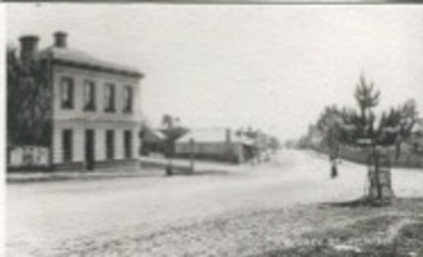
Photograph, Sydney Street Kilmore, 1880's
2.5x1.5 inch black and white photograph of 1 Powlett street, the Court House Hotel, former colonial bank of Australasia. Corner of Powlett Street and Lancefield Road. Copy printed on card stock. Two story light coloured rendered building. The intersection of Lancefield Road, Powlett Street, Sydney Street and (modern day) Skehan Place. With a view straight down Sydney Street. One figure crossing the road.Writing on the back: PHO-00004hotels, historical towns -
 Lakes Entrance Historical Society
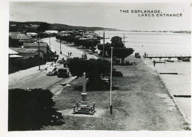
Postcard - Esplanade Lakes Entrance, 1945c
Original from wallet of miniature postcards produced by Bulmer, two copies. 01419.1 and .2 Also two enlargements 17 x 25 cmBlack and white small format postcard of Esplanade, taken from the WW2 Air Observers Spotting Tower. In the foreground is the Cenotaph erected 1922 on the grass verge between road and lake. Trimmed WW1 Cypress trees also on verge. Cars and truck on highway all travelling in easterly direction. Houses and businesses on north side of road, Princes Highway, which follows the margin of the lake shore. Lakes Entrance VictoriaThe Esplanade Lakes Entrancetownship, waterfront, transport, world war 1939 - 1945, world war 1914-1918 -
![Map, Plan of Subdivision [Allotments along Lerderderg, George and McFarland Streets]](/media/collectors/5e461d8021ea67224c82f2a1/items/675d7243165f146b8adfc656/item-media/675d72d7165f146b8adfc859/item-fit-380x285.jpg) Bacchus Marsh & District Historical Society
Bacchus Marsh & District Historical SocietyMap, Plan of Subdivision [Allotments along Lerderderg, George and McFarland Streets]
This map shows allotments of land on the northern side of Lerderderg Street from Gisborne Road through to the approximate site of the present day Bacchus Marsh Primary School. There are also allotments shown on the southern side of McFarland Street between George Street and Gisborne Road. Larger allotments of land are shown extending northwards towards Masons Lane. Inscribed at the top of the map are the words, 'Plan of Subdivision of Cr Pors (Crown Portions) 12 & 13 & Allotments 1,2,3,4, Block 3, Parish of Korkuperrimul, County of Bourke'. The date of the map has not been established but the absence of the Bacchus Marsh Primary School on the map suggests it may have been produced prior to 1865 when the primary school was built in Lerderderg Street.Single page map showing house block size land allotments in the Lerderderg, George Street and McFarland Street area of Bacchus Marsh with larger allotments north of this area towards Masons Lane also shown. Scale 150 feet to 1 inch. Part of a set of maps which are pasted into a bound volume containing 76 maps or plans in total. High resolution digital image stored on BMDHS computer network. bacchus marsh victoria maps, lerderderg street land allotments, mcfarland street land allotments -
 South Gippsland Shire Council
Painting, Watercolour, Memories, 1994
Framed watercolour landscape titled "Memories" (House at Buchan South) painted by Jan Long. Set in white and grey card double window mount with brown wood frame. Small brass plaque affixed to lower edge of mount. Note: Item approved for deaccession August 2023. SGSC will now follow deaccession procedures as outlined in the Arts and Civic Memorabilia Collection Policy - https://www.southgippsland.vic.gov.au/downloads/file/2763/arts_and_artefacts_collection_policy_c69. -
 Glenelg Shire Council Cultural Collection
Painting, Ruth Denny, Gardens Cottage Portland 1857, 1967
CEMA Art collectionThe painting depicts a blue stone building with green door. On either side of the door is a window and there is a chimney at either end of the roof. The side of the house closest to the viewer is overgrown with vegetation which extends up to and covers the chimney. To the right of the building is a green fence with a leaf-less tree behind. To the left of the building is a smaller green fence with several green trees behind. The work has a plain wooden frame with a mount and glass.Front: Gardens Cottage Portland 1857 Ruth Denny 1967 (black, handwritten) Back: Sticker: DEANS MU 8291 FOR FRAMING 346 LT. COLLINS ST., MELB. NO. 20438 Yellow sticker: 3033portland, female artist, female, women, botanic gardens, curator's cottage -
 Bendigo Historical Society Inc.
Photograph - T C WATTS & SON COLLECTION: CARPENTER STREET, BENDIGO, 1927
Alexander Fraser lived at 178 Carpenter Street with his wife Mary. He was a builderBlack and white photograph mounted on rectangular grey board. House, cement rendered double fronted bungalow central porch with apex roof. Flower boxes on porch [PTO] ramp to side door on left. Leadlight windows on top of front door and windows. On back of photo board ' Frasers Carpenter Street, £1200 sewered' Date stamp: 9 December 1927, on back. Sold for £3650 with certain coverings, 19.10.50.Frank A. Jeffree Bendigoplace, building, residential, stamped on back in rectangle ''t.c. watts and son/auctioneer/estate agents/253 mitchell street/bendigo'' stamped on back in circle ''royal historical society of victoria, bendigo branch'' -
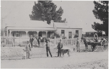 Linton and District Historical Society Inc
Photograph, O'Beirne Residence, office and buildings, wool and skin business
Original O'Beirne family home on Skipton Road, Linton, adjacent to office of their wool and skin business.Black and white copy of original photograph showing a weatherboard house with verandah and lattice work, next to a smaller building (office) which has two windows, a door and no verandah. One pine tree behind the buildings and one to the right of photograph. A light coloured picket fence in front of the buildings with a gate half way along. Six men, two children, a dog and two horses (one with cart) in front of the buildings.o'beirne residence, house, home, building, office, shed, business, children, horse cart, dog (buller), francis o'beirne, francis john (frank), harry o'beirne, rod o'connor (bookkeeper), charlie todd, jack cox, roger o'beirne, frank hall butcher from piggoreet, wool and skin business -
 Lakes Entrance Historical Society
Postcard - Backwater, Bulmer H D, 1922c
Black and white photographic postcard, showing early aerial view of township of Lakes Entrance, Cunninghame Arm, North Arm and sand dunes, ocean in lower foreground, Eastern wharf and various boats on lake. Princes Highway went along Esplanade, Myer Street and Roadknight Street, very little vegetation on sand dunes, no foot bridge yet, good view of North Arm, few houses. Lakes Entrance VictoriaLakes Entrance and Backwater from the Air.islands, aerial photograph, waterways, topography, township -
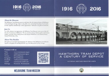 Melbourne Tram Museum
Book, Adam Chandler, "Hawthorn Tram Depot a Century of Service", Jul. 2016
Colour printed book - 8 pages, A5 size, centre stapled, printed on heavy paper, titled "Hawthorn Tram Depot a Century of Service", providing details of the Hawthorn Tram depot, the Hawthorn Tramway Trust, HTT, it services, substation, opening, amalgamation, uniforms and redevelopment. Has the details of the Museum on the rear cover. Prepared by Adam Chandler July 2016. Printed for sale at the 2016 Melbourne Open House depot.trams, tramways, hawthorn, fohtd, depots, pamphlets, htt, substation, uniforms, construction -
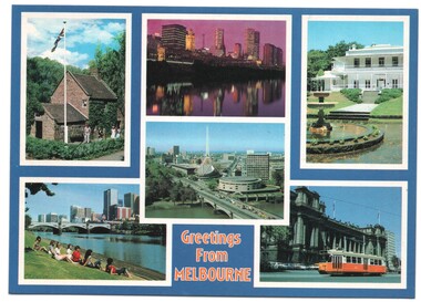 Melbourne Tram Museum
Postcard, Biscay Greetings, "Greetings from Melbourne" - 6 photos of Melbourne trams, mid 1990's
Colour postcard divided back - Biscay Greetings, series of 6 photographs of Melbourne, with the words "Greetings from Melbourne" on the lower edge. Features Cook's cottage, Banks of the Yarra River, Arts Centre, Como House and a Z class tram outside Parliament. Back has space for name and address, stamp and a message and details of the postcard. Produced by Biscay Greetings, possibly mid 1990's. Card No. BG 178.trams, tramways, postcards, yarra river, z class, melbourne -
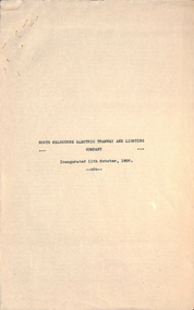 Melbourne Tram Museum
Document, Peter Duckett, "North Melbourne electric Tramway and Lighting Company", late 1940's?
Manuscript - 3 foolscap typed - 1st page a title page, titled "North Melbourne electric Tramway and Lighting Company", written by Peter Duckett. Not dated, possibly late 1940's. Outlines the history of the formation of the company, the routes, track construction, depot, power house, car barn, rolling stock, tramcars, overhead and take over by the MMTB - "what is now one of the worlds finest electric tramway undertakings."trams, tramways, nmetl, essendon, keilor rd, saltwater river, track construction, essendon depot, power station -
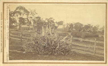 Bacchus Marsh & District Historical Society
Photograph, Agave Americana plant with view of Anglican and Presbyterian Churches in background, Bacchus Marsh 1883
This image appears to have been created to depict this good size Agave Americana plant, also known as the 'Century Plant'. Agaves are an introduced species to Australia. Their local propagation in Victoria is mentioned in Victorian newspapers as early as the 1850s. By the 1870s they appear to have become fairly common but still relatively novel. The side by side view of the Holy Trinity Anglican and Saint Andrews Presbyterian Churches forms an interesting frame for this botanical study. On the far right of the image in the background can be seen the Presbyterian Church Manse built in 1858 and demolished in the 20th century.Small sepia 'carte de viste' style unframed photograph on card with gold border framing photograph. Housed in the Jeremeas Family Album which contains photographs of Bacchus Marsh and District in 1883 by the photographers Stevenson and McNicoll. In the foreground of this image is an Agave Americana plant growing alongside a post and rail fence. In the background can be seen the Anglican Holy Trinity Church on the left and Saint Andrews Presbyterian Church on the right.Printed On the front: Stevenson & McNicoll. Photo. 108 Elizabeth St. Melbourne. COPIES CAN BE OBTAINED AT ANY TIME. On the back: LIGHT & TRUTH inscribed on a banner surmounted by a representation of the rising sun. Copies of this Portrait can be had at any time by sending the Name and Post Office Money Order or Stamps for the amount of order to STEVENSON & McNICOLL LATE BENSON & STEVENSON, Photographers. 108 Elizabeth Street, MELBOURNE. stevenson and mcnicoll 1883 photographs of bacchus marsh and district, churches bacchus marsh, holy trinity anglican church bacchus marsh, holy trinity church of england bacchus marsh, saint andrews presbyterian church bacchus marsh, plants, agaves, exotic plants, agave americana -
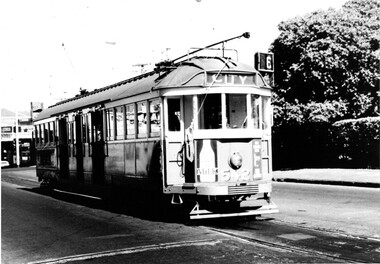
 Melbourne Tram Museum
Photograph - Black & White Photograph/s, "Bourke St looking east from Queen St 1921", 1980's?
Reproduced photograph, sepia toned of "Bourke St looking east from Queen St 1921" with the Post Office, Myers, the Leviathan, and Parliament House in the distant background. Also a shop "Hatters Kenos Mercers" The cable tram has the destination of "Spencer St" One of a series of four photographs produced by an unknown person/company. Two small size prints held. See Reg Items 301 and 5274 for other copies.On the rear of 587 "Cable Tram prints $10/set"trams, tramways, melbourne, bourke st, cable trams, post office -
 Melbourne Tram Museum
Photograph - Black & White Photograph/s, tram W2 542 at the Glen Iris terminus, 1960's
Black and white photograph of tram W2 542 at the Glen Iris terminus, with the destination of City route 6. Has the large hedge of a house and shops in the background. Trams has good appearance, possibly just after a repaint. Has a number of adverts on the front - including one for Milk. Tram at the intersection of Malvern and Darling Roads, Glen Iris. Printed on Fujichrome paper. Not known who took the photograph or when it was printed.Stamped in black ink on back "TMSV Sales"trams, tramways, glen iris, darling rd, route 6, tram 542 -
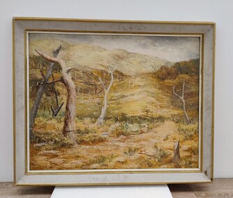 Royal Australian and New Zealand College of Obstetricians & Gynaecologists (RANZCOG)
Painting, John 'Jack' Courier, Untitled (Landscape), 1965
It is likely this item was received from the estate of John 'Jack' Courier. Courier left a bequest to the College consisting of a significant number of artworks by himself and others.Untitled landscape painting. The painting depicts a series of dead tree trunks in a hilly landscape, with the suggestion of a path between the trees in the foreground. There are indistinct examples of trees with leaves in the middle background on the left and right of the painting. Lower right hand corner of painting is inscribed 'Courier/65'. The painting is housed in a white wooden frame with golden trim. The number '10', enclosed in a circle, is handwritten on the upper right hand corner of the back of the frame.'Courier/65'. -
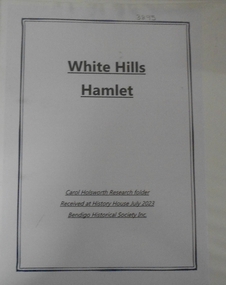 Bendigo Historical Society Inc.
Document - RESEARCH FOLDER COLLECTION: WHITE HILLS HAMLET, 1990 - 2015
Folder of research material compiled by Carol Holsworth. Received at History House in July 2023. White Hills Hamlet Includes Newspaper articles including many photographs of properties in the White Hills area advertised for sale Historical information about White Hills Hamlet properties Family history information about former residents of the White Hills area Notes based on electoral rolls, local directories, and rates records MapsCarol Holsworthbendigo, history, white hills hamlet -
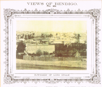 Bendigo Historical Society Inc.
Photograph - LONG GULLY HISTORY GROUP COLLECTION: TOWNSHIP OF LONG GULLY
BHS CollectionYellow tone photo of the Township of Long Gully. At the top is Views of Bendigo No. 28. There is a decorative frame around the photo. The photo has tall chimneys in the background. Iron Bark Hill and Victoria Hill are mentioned. There are houses in the centre and in the foreground is a rough picket fence. It is a N J Caire Photo Sandhurst and a Carey & Wenhorn's Print. Forbes & Holmes, Agents. The photo is mounted on a yellow card which is mounted on a purple card and laminated.bendigo, history, long gully history group, the long gully history group - township of long gully, views of bendigo no 28, casey & wenburn's print, iron bark hill, victoria hill, forbes & holmes, n j caire -
 Clunes Museum
Equipment - HEADLIGHT & BATTERY SET, CHENEY PRODUCTS LIMITED, C1930
USED IN THE CLUNES HOSPITAL.1 SURGICAL HEAD LIGHT, PLASTIC HEAD-BAND AND FOAM MATERIAL CUSHION, WITH ADJUSTABLE METAL ARMS, LIGHT GLOBE & REFLECTOR. OBJECT SIMILAR TO VTG LEMPERTH STORZ MEDICAL SURGICAL HEADLIGHT. TWO POINT ELECTRICAL PLUG WITH PLASTIC BROWN COVERED WIRING .2 WOODEN BOX WHICH WOULD HOUSE 3 BATTERIES. A DIAL ON THE TOP OF THE BOX (Min to Max) AND TWO SCREW TERMINALS, METAL HINGES & CLASPCHENEY ENGLAND INSCRIBED ON THE TWO METAL HINGES ON THE REAR OF THE BOXsurgeon's headlight, medical & surgical, localhistory -
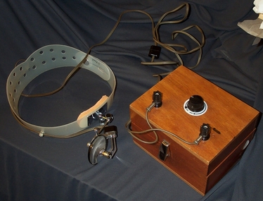
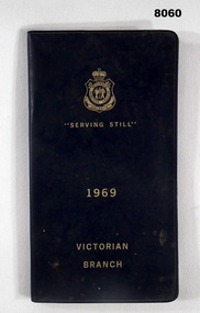 Bendigo Military Museum
Accessory - DIARY, RSL VICTORIA 1969, Victorian RSL State Branch, C. late 1968
The pages of written text cover everything the RSL does from welfare, commemorative, legal aid, membership, women's auxiliary and housing to name a few. Bert Pollard was an active RSL Member involved in Committee and the District Board. He served in WW2.Diary black plastic covers with gold text on front cover, top has the RSL logo followed by "Serving Still - 1969 - Victorian Branch", inside first page are details re Anzac House Melbourne, there are 28 pages of written text, page for members personal details, 4 blank pages for notes, the Calendar itself folds out for viewing and to enter notes, last page has a 12 month calendar. "Bert Pollard, phone 5433741"brsl, smirsl, diary -
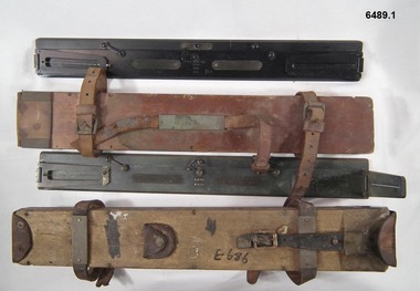 Bendigo Military Museum
Instrument - Plane Table Surveying - Simple Alidade, ER Watts and Son, London, 1938
The Plane Table Alidade was used as the sighting Instrument in the production of historical manual hand drawn maps. A Plane Table Board mounted on a tripod is levelled and the Alidade is placed on the table with the vanes perpendicular to the it. Each sighting vane has a central thread lined up on the target and the angle to that target point is then drawn on the map sheet using the beveled fiducial edge. Plane Table Surveying is used as a quick method where less accuracy is required or needed. Plane table Surveying is a relatively portable and inexpensive method and was used extensively before the advent of sophisticated surveying instruments. The photo at 6489.2 is an Australian Army Survey Corps Party using a Plane Table Alidade in Syria during WWII. See also item 6580 which is the Plane Table with tripod legs that was used with the Alidade.Two Plane Table sighting instruments (Alidade) used for historical manual map making housed in wooden transit boxes. A brass instrument with folding sights at each end and a beveled fiducial edge in one edge. The front sight is the object vane and the rear sight is the sight vane. There is a sliding arm attached to the base to draw parallel lines to the fiducial edge. Very slight differences in model between these two instruments.First Instrument, "ER Watts and Son, London, 1938, MkII, Box Label 423. Second Instrument - R. E-Co, Mk.II, stamped E686, Box Label 686.royal australian survey corps, rasvy, fortuna, army survey regiment, army svy regt, asr -
 Bendigo Historical Society Inc.
Document - NEW CHUM & VICTORIA LINES OF REEF - NOTES ON VICTORIA HILL FOR TOURIST ATTRACTION
Handwritten notes outlining a plan for Victoria Hill, Central Nell Gwynne and New Chum Hill to be the focal position for a tourist attraction. Outlines steps to be taken to do the work and a mining museum at the Central Nell Gwynne. On the back of the page is a sketch of Victoria & New Chum Hills. On the plan is the Battery, Rae, Rae's House, Rae's Open Cut, Wittscheibe, Midway, Victoria Quartz, Lansell's 180 Shaft and the Recreation Reserve.document, gold, new chum & victoria lines of reef, central nell gwynne, new chum hill, bendigo and district tourist development association, victoria hill, lansell's big 180, victoria quartz, rae's open cut -
 Orbost & District Historical Society
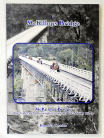
book, McKillops Bridge, 2014
This book was purchased new by Orbost & District Historical Society. Written by Buchan historian, Rhonda Coates, the book was commissioned by Tubbut Neighbourhood House following a commemoration event in 2002 when many people gathered for a special day organised by Sister Helen Barnes and the Tubbut community. (ref. Bombala Times)This book is a useful research item.A paper back book, titled McKillops Bridge, written by Rhonda Coates. On the front cover is a photograph tractors crossing the bridge during the Great Snowy River Tractor Stampede ( The Snowy River Tractor Strampede, a 560-kilometre journey, is organised by the Bega and District Historical Machinery Club every January - the first being held in 2009.) this photograph is inset over an earlier phpotograph by Howard Bulmer c 1936. The book contains the history of the bridge, photographs of the bridge and times before its construction.On front fly-Orbost &District Historical Society Incmckillops-bridge -
 Glen Eira Historical Society
Document - Chinese Community in Glen Eira
Five pages of research by Carol Stals for her U3A Caulfield History program 2013. Includes article from THE ARGUS of 07/03/1905, excerpts from SAND, SWAMP AND HEALTH by Murray and Wells 1980 and three colour photocopies of photographs of two houses inhabited by local market gardeners.elsternwick, market gardeners’ association, elsternwick leader, ruby street, malva street, reeves william, murton hall, halls, ocean street, gould mrs. s., belmont, house names, munn harry, ormond hall, taylor herbert, church of england, raymond rev. h., north road, grange road, wattle road, glen huntly road, joss house, smith a. w., glen huntly post office, king f. i., vickery street, bentleigh east, thomson memorial church, north road, booran road, brady road -
Glen Eira Historical Society
Letter - Howitt Road, 32, Caulfield North, Fooks House
A copy of a one page typed letter from Ian Pausacker of the National Trust of Australia (Victoria) to the Manager of the Planning Section of the City of Glen Eira, dated 08/02/2002, informing the Manager that Fooks House at 32 Howitt Road, Caulfield north has been classified by the National Trust.city of glen eira, fooks house, howitt road, caulfield north, heritage studies, the national trust of australia (victoria), historic buildings -
 Eltham District Historical Society Inc
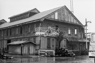
Photograph, Timber salvage during demolition of former warehouses and wool sheds at Victoria Dock, Melbourne, c.May 1974, May 1974
Oregon timber beams and Jarrah flooring were salvalged by George Coop and incorporated into extensions undertaken to 68 Mount Pleasant Road, Eltham. Timber collection/storage for the house extension took years and much was stored on the front lawn for nearly ten years. The renovations were undertaken c.1983.Digital TIFF file Scan of 35mm Kodak Plus-X black and white negative transparency. Also 5 x 13 cm black and white print68 mount pleasant road, george coop collection, victoria docks, wool shed, eltham, houses -
 Eltham District Historical Society Inc
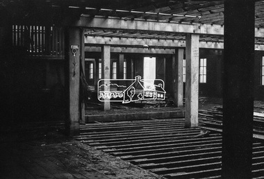
Photograph, Timber salvage during demolition of former warehouses and wool sheds at Victoria Dock, Melbourne, c.May 1974, May 1974
Oregon timber beams and Jarrah flooring were salvalged by George Coop and incorporated into extensions undertaken to 68 Mount Pleasant Road, Eltham. Timber collection/storage for the house extension took years and much was stored on the front lawn for nearly ten years. The renovations were undertaken c.1983.Digital TIFF file Scan of 35mm Kodak Plus-X black and white negative transparency. Also 5 x 13 cm black and white print68 mount pleasant road, george coop collection, victoria docks, wool shed, eltham, houses