Showing 2009 items
matching bendigo show
-
 Bendigo Historical Society Inc.
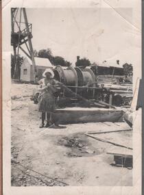
Photograph - ALBERT RICHARDSON COLLECTION: NEW ST MUNGO EAST SHAFT
Black and white photograph. Image shows poppet head legs top left, winding machine in centre. Woman standing beside winding machine, wearing a hat and dress. Appears to be 1950's? Written on back of photo: Central Bendigo? Was the original New St. Mungo East Shaft'bendigo, mining, new st. mungo east shaft -
 Bendigo Historical Society Inc.
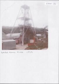
Photograph - KEN BICE COLLECTION: WATTLE GULLY GOLD MINE
Colour photograph, faded and laminated. Image shows poppet head in centre, mining sheds surrounding poppet head. Written on bottom of image : Wattle Gully Mine 1979'mining, underground equipment, wattle gully gold mine -
 Bendigo Historical Society Inc.
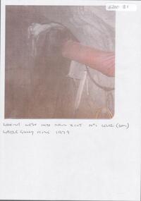
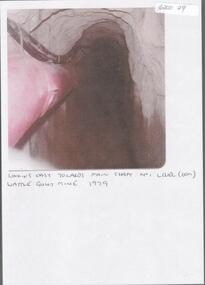
Photograph - KEN BICE COLLECTION: WATTLE GULLY GOLD MINE
Colour photograph, faded and laminated. Image shows underground tunnel with air line on RH side. On bottom of image:' looking west into main xcut No. 1 level (60m) Wattle Gully Mine 1979.'mining, underground equipment, wattle gully gold mine -
 Bendigo Historical Society Inc.
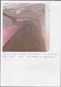
Photograph - KEN BICE COLLECTION: WATTLE GULLY GOLD MINE
Colour photograph, faded and laminated. Image shows an underground tunnel with air/electricity wiring on LH side of decline. Written on bottom : looking east towards main shaft. No. 1 level (60m) main xcut 1979. Bob Farrell in background'mining, underground equipment, wattle gully gold mine -
 Bendigo Historical Society Inc.
Photograph - KEN BICE COLLECTION: WATTLE GULLY GOLD MINE
Laminated, faded colour photograph. Image shows stope with air lines. On bottom of image: ' looking east towards main shaft No. 1 level, Wattle Gully Mine 1979'mining, equipment, wattle gully gold mine -
 Bendigo Historical Society Inc.
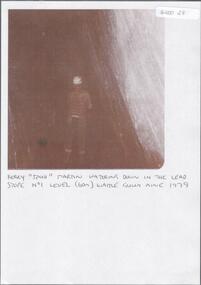
Document - KEN BICE COLLECTION: WATTLE GULLY GOLD MINE 1979
Laminated, faded black and white photograph. Image shows men with back to the camera, standing in a stope with hard hat and fluoro vest. On bottom of image 'Kerry Spud Martin watering down in the lead stope No. 1 level ( 60m) Wattle Gully Mine 1979'.mining, underground equipment, wattle gully gold mine -
 Bendigo Historical Society Inc.
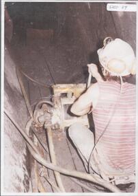
Document - ALBERT RICHARDSON COLLECTION: WATTLE GULLY GOLD MINE
Black and white photo, faded, laminated. Image shows Ken Bice operating a scraper. On back of image ' Ken Bice operating a scraper in intermediate level 6 metres agove No. 1 level (60m) Wattle Gully Mine 1980 working on Gibbers Reef.'mining, underground equipment, wattle gully gold mine -
 Bendigo Historical Society Inc.
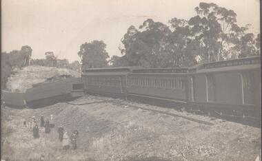
Photograph - TRAIN DERAILMENT
Black and white photograph showing a train derailment possibly near Castlemaine. The phot shows three carriages toppled over, various people are standing by looking. The photo is from A. Verey and Co. Castlemaine. A type written letter from Trevor Lamb gives a context to the photo.railways, accident, derailment -
 Bendigo Historical Society Inc.
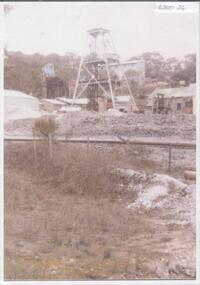
Photograph - KEN BICE COLLECTION: WATTLE GULLY GOLD MINE
Laminated faded black and white photograph of the Wattle Gully Gold Mine, Castlemaine. Image shows poppet head, mining shed. Written on back of photo ' Wattle Gully Mine from Fryers Road, 1979'mining, equipment, wattle gully gold mine -
 Bendigo Historical Society Inc.
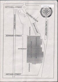
Flyer - HUGH ENNIS COLLECTION: FLYER SHOWS LOCATION MAP FOR THE OPENING OF THE BENDIGO MARKETPLACE ON TUESDAY 31ST OCTOBER 1995, 31/10/1995
... Flyer shows location map for the opening of the Bendigo ...Flyer shows location map for the opening of the Bendigo Marketplace on Tuesday 31st October 1995 -
 Bendigo Historical Society Inc.
Newspaper - LYDIA CHANCELLOR COLLECTION: SACRED HEART CATHEDRAL BENDIGO PROGRESSIVE WORK CARRIED OUT, 1972
LYDIA CHANCELLOR COLLECTION: SACRED HEART CATHEDRAL BENDIGO Progressive Work Carried Out Shows the progressive work on the spires and back section of the church. Handwritten on the article: Herald Aug 29 1972bendigo, history, churches -
 Bendigo Historical Society Inc.
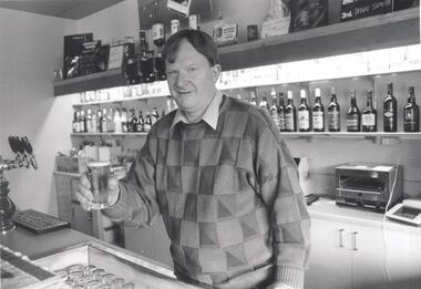
Photograph - PHOTOGRAPH. BARMAN HOLDING A GLASS OF BEER
Photograph. Harcourt Barman, Barry Johansen holding a glass of beer. Background shows shelving and top shelf drinks. -
 Bendigo Historical Society Inc.
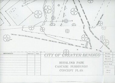
Plan - MERLE HALL COLLECTION: ROSALIND PARK CREATIVE VILLAGE BENDIGO PROJECT CONCEPT PLAN, 1993
MERLE HALL COLLECTION: ROSALIND PARK CREATIVE VILLAGE BENDIGO PROJECT Concept Plan City of Greater Bendigo Rosalind Park Cascade Surrounds Concept Plan number GB095 Sheet 1 of 2 Level Book 365, Backup No Tape 01, Computer File No. ROS QEO. Large Sheet which shows the location of utilities, vegetation, drains, embankments etc. June 1993 -
 Bendigo Historical Society Inc.
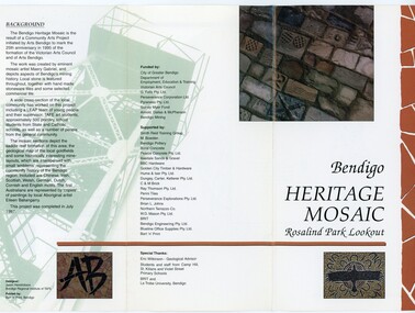
Pamphlet - MERLE HALL COLLECTION: ROSALIND PARK CREATIVE VILLAGE BENDIGO PROJECT PAMPHLET, 1995
Merle Hall Collection: Rosalind Park Creative Village Bendigo Project Pamphlet for Rosalind Park Lookout - two copies. One side of the pamphlet has a layout image of the five sections of the mosaic and the poppet head base. The sections are numbers 1 to 5 Section 1: A stylised representation of the main Bendigo Goldfield based on a geological plan (Publish in 1992). It shows the lines of reef, including the famous Hustlers, Garden Gully and New Chum. Section 2: A typical cross section of the Bendigo Goldfields Section 3: The mine layout shown in this design features part of the Garden Gully line of reef. Section 4: Shown here is the Iron Bark mine on the Sheepshead reef. It has an interesting pattern of drives, stopes and winzes. Section 5: In this section the artist uses gold as her inspiration. The larger mosaic shows quartz veins winding through the earth containing gold in its various forms. The smaller mosaic represents the atomic structure of gold. It shows the the nucleus, the six shells of the atom, their electrons and orbits. The other side of the pamphlet describes the background of the community arts project, the artist, and volunteer workers, also notes mentioning the Bendigo community history. It also lists the donors for funding and business's that supported the project, with special thanks to Eric Wilkinson - Geolpogical advoser, the students and staff from Camp Hill, St Killians and Violet Street primary schools. BRIT and La Trobe University, bendigo. -
 Bendigo Historical Society Inc.
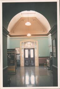
Photograph - FORTUNA COLLECTION: PHOTOGRAPH
Photograph, colour on backing board. Photo shows an entrance doorway with double doors, leadlight above and both sides of doors, domed ceiling, polished floor -
Bendigo Historical Society Inc.
Map - MAP: VIRGINIA MINE GARDEN GULLY LINE OF REEF
Map of Virginia Mine on the Garden Gully line of reef, Eaglehawk, transverse section. Shaft, levels and Garden Gully anticlinal axial line drawn. Key shows types of formations - quartz, spurs, sandstone, slate, cleavage, lava. This map forms part of the Geological Survey of Victoria, Structure of Bendigo Goldfield report, No. 47, 1923. H.Herman, late Director of Geological Survey.Geological Survey Victoria, Geological Survey Office, Bendigo.bendigo, gold mining, virgina mine eaglehawk, eaglehawk, bendigo, gold mining, virginia mine, garden gully line of reef. -
 Bendigo Historical Society Inc.
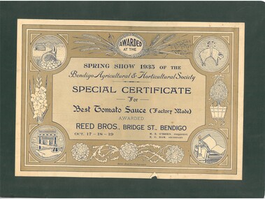
Document - REED BROS: BRIDGE ST BENDIGO AWARDED AT THE BENDIGO AGRICULTURAL AND HORTICULTURAL SOCIETY SPRING SHOW 1935 BEST TOMATOE SAUCE, 1935
Reed Bros: Bridge St Bendigo Special Certificate Awarded at the Bendigo Agricultural and Horticultural Society Spring Show 1935 Best Tomatoe Sauce (Factory Made) Oct 17-18-19bendigo, history, reed brothers -
Bendigo Historical Society Inc.
Map - SECTIONS ACROSS BENDIGO GOLDFIELD
... Map in three sections showing sections across Bendigo Gold...Bendigo Historical Society Inc. Bendigo Historical Society ...Map in three sections showing sections across Bendigo Gold Field, showing anticlines, synclines, faults, stratigraphical zones and mines along the reef lines. Key shows rock types Castlemaine, Bendigo B1, B2, B3 and B4, and Lancefieldian. First part of map shows sections A-A, B-B and C-C. Reef lines drawn with mines listed: Fault line shown are the Carshalton, Stafford, New Chum, Virginia and Clarence. A datum line shows 600 ft above sea level. On bottom of plan: ' Prepared in the Geological Survey Office, Bendigo, under the direction of H. Herman, late Director of Geological Survey, from surveys by H.S. Whitelaw, Field Geologist, assisted by E.S. Usher, A.J.J. Moore and R.A. Keble.' Second section of map shows sections D-D, and E-E. Fault lines listed are the Tambour Major fault, Carshalton fault, Stafford fault, Nell Gwynne fault, New Chum fault, Deborah fault. Third section shows sections F-F and G-G. Fault lines listed are the Bird Reef fault, Kangaroo Gully fault, Langdon fault, Carshalton fault, Nell Gwynne fault, Spring Gully fault, Hustlers fault, Gravel Hill fault, Ordes fault, Thanet fault. This map forms part of the Geological Survey of Victoria, Structure of Bendigo Goldfield report, No. 47, 1923. H.Herman, late Director of Geological Survey.Geological Survey of Victoriabendigo, gold mining, reef line maps -
 Bendigo Historical Society Inc.
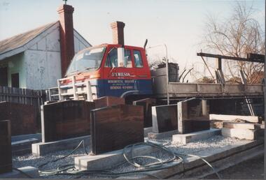
Photograph - BENDIGO BUSINESSES COLLECTION: J. B. WILSON
Colour photograph of J. B. Wilson monumental mason Carpenter Street. The photo shows a red and blue truck in the yard. An house can be seen on the left and a row of display grave stones at the front. The photo was taken in July 1993.bendigo, business, j.b. wilson -
 Bendigo Historical Society Inc.
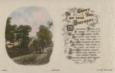
Postcard - POSTCARD. TO GREET YOU ON YOUR BIRTHDAY
Postcard. Photo on front shows one boy leading the horse, whilst another boy sits atop the load of hay. To Greet You on Your Birthday. Rear. Names deleted. -
Bendigo Historical Society Inc.
Document - BENDIGO AND VICTORIA HILL REPORT ON GEOLOGY
Report, 8 pages, on the geology of Bendigo district and Victoria Hill, produced by the Geological Survey Dept., Victorian Government. G.J. Medwell, Geologist. 19.10.1967. On front 'Geological Survey of Victoria. Mines Department Victoria. Report on Geology of Bendigo and of Victoria Hill Area' Letter attached inside front cover to J.C.Balfour, Minister of Mines to G.A. Lambert, Liberal Party, Sunshine, Victoria, sent with book for his information. Report contains: Cobaw batholith and North Harcourt Bendigo goldfield generally Trought, reefs, saddles and spurs Victoria Hill mines; Victoria Consols, Great Central Victoria, Victoria Quartz, Lansells 180, North Old Chum. Maps attached show part of New Chum line of reef and a handdrawn map of Rae's Cutting.bendigo, mining, victoria hill, bendigo goldfield -
 Bendigo Historical Society Inc.
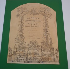
Document - PRIZE CERTIFICATE
... ORGANIZATION Club/society agricultural and horticultural show Bendigo ...Bendigo Agricultural and Horticulture Society Prize Certificate awarded to Mr J Matchett of Sandhurst special prize for fancy pony cart harness March 24th 1880. Signed by the President and Secretary.organization, club/society, agricultural and horticultural show -
 Bendigo Historical Society Inc.
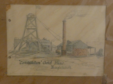
Painting - CONSTELLATION GOLD MINE EAGLEHAWK
Crayon artwork. Art shows poppet head with chimney and brick and timber engine house. Written on bottom ' Constellation Gold Mine, Eaglehawk. A.A. Perry 1958' Two punch holes on LH side. Written on back in pencil: This mine was west of the Victortia St railway gates on N side. I used to read the electricity meter here about 1918 - 20. This drawing was done from memory in 1958 when I was getting over a sickness'.eaglehawk, mining, constellation mine -
 Bendigo Historical Society Inc.
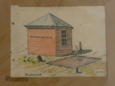
Painting - WEIGHBRIDGE EAGLEHAWK
Watercolour and black pen. Weighbridge, Eaglehawk. Art shows small weatherboard building alongside weighing platform. On bottom 'Eaglehawk, A.A. Perry' Two punch holes on LH side.eaglehawk, commercial, weighbridge -
 Bendigo Historical Society Inc.
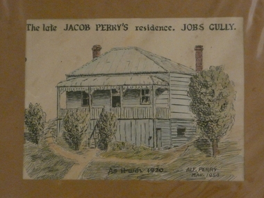
Painting - JACOB PERRY'S RESIDENCE JOBS GULLY
Watercolour and black pen, painted by Alf Perry 1954. Painting shows elevated weather board house, two brick chimneys. Stairs up to front verandah. Written across the top :'The late Jacob Perry's residence. Jobs Gully.Written on bottom of artwork ' As it was 1920, Alf Perry 1954. Written by Alf Perry, in pencil on the back, is the following: ' Drawn from the house in March 1954 but as I knew it in 1920. A verandah is built at the right hand side of the house now. The window below floor level at the right let in light to the little workshop my grandfather used. I used to go up and make (?) little bone knives and forks out of ordinary bones. Alf Perry 1954'.house, private, jacob perry, jobs gully -
Bendigo Historical Society Inc.
Photograph - DEBORAH GOLD MINE, GOLDEN SQUARE
Black and white photograph of Deborah Gold Mine, Abel Street, Golden Square. Image shows large mining sheds (engine house, boiler room) with tramway and poppet head at rear. Two ore bins on RH side. Large mullock hills at RH rear of ore bins. Written on back of photo 'Deborah Reef Gold Mines NL 20.3.37' Paper with photo states:' The Deborah Gold Mine, Abel Street. The poppet head was moved from the Windmill Hill mine Long Gully. This photograph was taken in March 1937 after a further 10 heads had been added to the battery'bendigo, mining, deborah gold mines -
 Bendigo Historical Society Inc.
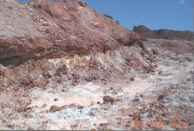
Photograph - RALPH BIRRELL COLLECTION: TUNNEL BELOW THE CEMENT, WHITE HILLS
Colour photograph: 'showing tunnels below the cement where the miners chipped the undersurface to get the gold The thickness of the cement can be seen' Loose sand and gravel above the cement has already been removed. Image shows layer of cement, tunnel visible on LH side, clay and gravel in front. (see Mosaic 4400.220 for detailed information regarding the White Hills, written by Dr. Ralph Birrell)bendigo, mining, white hills -
 Bendigo Historical Society Inc.
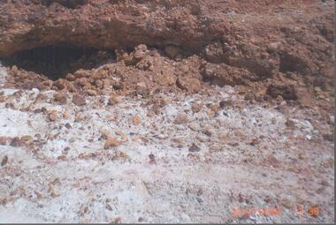
Photograph - RALPH BIRRELL COLLECTION: WHITE HILLS MINING SITE
Colour photograph 'showing tunnels below the cement where the miners chipped the undersurface to get the gold The thickness of the cement can be seen'. Loose sand and gravel above the cement has already been removed. Image shows mining tunnel visible going in under the cement. White clay in foreground. (see Mosaic 4400.220 for detailed information regarding the White Hills, written by Dr. Ralph Birrell)bendigo, mining, white hills -
 Bendigo Historical Society Inc.
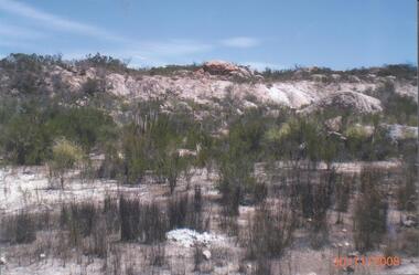
Photograph - RALPH BIRRELL COLLECTION: VIEW OF WHITE HILL
Colour photograph of White Hill area - possibly at First White Hill. Image shows white clay and gravel, low level bushes, possibly Chinese Scrub on site. 'The rim of the pit showing an exposed boulder in situ' ( in foreground of image ) (see Mosaic 4400.220 for detailed information regarding the White Hills, written by Dr. Ralph Birrell)bendigo, mining, white hills -
Bendigo Historical Society Inc.
Photograph - FORTUNA COLLECTION: COMET MINE
Black and white photograph. Image shows lattice work metal poppet head, with elevated tramway leading to poppet head. Mine chimney on RH side, building extreme right Number 31 written top centre.bendigo, mining, comet mine