Showing 10395 items
matching plans
-
 University of Melbourne, Burnley Campus Archives
Work on paper, Garden Style and the Australian Landscape, September 2002
student work, assignment, plan, axonometric drawing -
 Flagstaff Hill Maritime Museum and Village
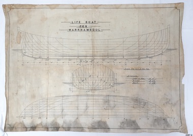
Plan - Vessel Line Drawing, Life Boat for Warrnambool, ca. 1900-1909
The plans were used for the construction of the lifeboat ‘Warrnambool’, which began 15th September 1909 and was completed almost 12 months later 1st September 1910. It was built at the Government Dockyard in Williamstown, Victoria, along the lines designed by Great Britain’s Royal Lifeboat Institution, and included whaleback decks fore and aft, mast and centreboard, and rudder and tiller hung from the sternpost. It could be propelled by both sail and oar. At that time Captain Ferguson was Chief Harbour Master and Mr Beagley was the foreman boat builder. Mr Beagley built the lifeboat with his fellow workmen. The boat was described as “… a fine piece of workmanship and does credit to her builders and designers…” It had all the latest improvements in shape, disposition of weight and watertight compartments, and it had space for a large number of people in addition to the crew. It appears that 'H Meiers' whose signature was on the plaque that was found concealed in the hull, was involved with the building of the lifeboat. His signature and the dates of the start and finish of the boat’s construction are pencilled on the raw timber 'plaque' found in the hull in the early 1990s when the lifeboat was being restored. It is interesting that the ‘Melbourne Directory’ of 1911, published by Sands and MacDougal, lists McAuley and Meiers, boat builders, Nelson Place foreshore, between Pasco and Parker Streets, Williamstown, (Victorian Heritage Database, ‘Contextual History, Maritime Facilities’), It is quite possibly the business of the person whose name is inscribed on the lifeboat plaque. Flagstaff Hill’s documentation also mentions that the keel was laid at ‘Harry Myers, boat builders, Williamstown, Melbourne’ – the name ‘Myers’ can also be spelled ‘Meiers’, which could be the same person as the Meiers in “McAuley and Meiers” (as mentioned in genealogy lines of Myers). The new lifeboat, to be named ‘Warrnambool’ was brought to town by train and launched at the breakwater on 1st March 1911 using the Titan crane (the old lifeboat built in 1858, was then returned to Melbourne in 1911). This new lifeboat was stationed at Warrnambool in a shed located at the base of the Breakwater, adjacent to the slipway. A winch was used to bring it in and out of the water. The lifeboat ‘Warrnambool’ was similar in size to the old lifeboat but far superior in design, build and sea-going qualities such as greater manoeuvrability. The ‘self-righting, self-draining design was “practically non-capsizeable” and even if the boat overturned it would right itself to an even keel and the water would drain away. The hull was built of New Zealand Kauri, using double diagonal planking, laid in two layers at right angles, with a layer of canvas and red lead paint between the timbers to help seal the planking. It has “… plenty of freeboard area, high watertight spaces between the deck and bottom… through which pipes lead…” The backbone timbers were made of Jarrah. The lifeboat Warrnambool was one of several rescue boats used at Port Fairy and Warrnambool in the early 1900s. In late 1914 the Warrnambool lifeboat and crew were used to help find what was left of the tragic wreckage of the Antares and were able to discover the body of one of the crewmen, which they brought back to Warrnambool. Between 1951 and 1954 the lifeboat was manned under the guidance of Captain Carrington. He held lifeboat practice each month on a Sunday morning, to comply with the Ports and Harbour’s request that lifeboats be manned by a strong and competent crew, ready for action in case of emergency. In the early 1960’s it ended its service as a lifeboat and was used in Port Fairy as a barge to help dredge the Moyne River, bolted to the Port Fairy lifeboat. Flagstaff Hill obtained the Warrnambool in 1975. In 1984 it was on display at Flagstaff Hill Maritime Village, Warrnambool. On 23rd May 1990, she was lifted from the water and placed in a cradle for restoration. The name ‘WARRNAMBOOL could be seen faintly on the lifeboat before it was restored. It was during the restoration that Flagstaff Hill's boat builder discovered the 'plaque' inside the hull. A copy of the blueprint plans has the name “V.E.E. Gotch” printed on it. His advertisement in Footscray’s ‘Independent’ newspaper of Saturday 11th May 1901 states he is “Principal and Skilled member (Naval Architect) to the Court of Marine Inquiry of Victoria and holds classes for naval architectural drawing and arithmetic.” The line drawing is significant for its connection with the lifeboat WARRNAMBOOL. The lifeboat is very significant to local and state history for its use in the lifesaving rescues of seafarers, particularly in Lady Bay. It was part of the local rescue equipment. It gave a half-century of service to the local community as a lifesaving vessel, including its involvement in retrieving the body of a shipwrecked crew member of the ANTARES. Line drawing in black ink and pencil on rectangular parchment or waxed linen. Drawing has diagrams of three profiles of a vessel, with measurements and connecting pencil lines on the left quarter. The plan is for the lifeboat named “Warrnambool”, which was built in Melbourne and completed in 1910. Old blue copies of the Lifeboat plan are archived also.“LIFE BOAT / FOR / WARRNAMBOOL” “Scale, One Inch to One Foot” “ “Length as shown 30’ – 8” “ “Breadth “ “ 8’ – 6 ½ “ “ “Depth “ “ 3’ – 4 ¾” “flagstaff hill, warrnambool, shipwrecked-coast, flagstaff-hill, flagstaff-hill-maritime-museum, maritime-museum, shipwreck-coast, flagstaff-hill-maritime-village, lifeboat, warrnambool lifeboat, boat plans, lifeboat plans, boat construction, boat building, line drawing, plan for lifeboat, life boat, life boat 'warrnambool', clinker design, 1910 lifeboat, life saving equipment, shipbuilding -
Bendigo Historical Society Inc.
Document - MARKS COLLECTION: PLANS AND INSTRUCTIONS FOR DUPLEX SAFETY BOILER
4 documents. Two plans showing measurements and details of Duplex Safety Boiler. Plans are drawn on dark blue paper, backed with material. A. On bottom of plan 'Sectional elevations of Duplex Safety Boiler New York 1881' B. On bottom of plan 'Plan for 50 hp Duplex Safety Boiler, ten 5ft sections' C. and D. Accompanying plans are two pages of instructions 'Directions for setting a Duplex Safety Boiler'. Written instructions in white pen on dark blue paper ( difficult to read, some faded ) 12 steps are outlined, with remarks at the bottom of the second sheet. This boiler could have been used in a Lansell mine ? (further research required).bendigo, mining, duplex safety boiler -
 Kew Historical Society Inc
Plan - Subdivision Plan, Goldthorns House Estate, 1940
Pru Sanderson, in her groundbreaking ‘City of Kew Urban Conservation Study : Volume 2 - Development History’ (1988), summarised the periods of urban development and subdivisions of land in Kew. The periods that she identified included 1845-1880, 1880-1893, 1893-1921, 1921-1933, 1933-1943, and Post-War Development. These periods were selected as they represented periods of rapid growth or decline in urban development. An obvious starting point for Sanderson’s groupings involved population growth and the associated economic cycles. These cycles also highlighted urban expansion onto land that was predominantly rural, although in other cases it represented the decline and breakup of large estates. A number of the plans in the Kew Historical Society’s collection can also be found in other collections, such as those of the State Library of Victoria and the Boroondara Library Service. A number are however unique to the collection.The Kew Historical Society collection includes almost 100 subdivision plans pertaining to suburbs of the City of Melbourne. Most of these are of Kew, Kew East or Studley Park, although a smaller number are plans of Camberwell, Deepdene, Balwyn and Hawthorn. It is believed that the majority of the plans were gifted to the Society by persons connected with the real estate firm - J. R. Mathers and McMillan, 136 Cotham Road, Kew. The Plans in the collection are rarely in pristine form, being working plans on which the agent would write notes and record lots sold and the prices of these. The subdivision plans are historically significant examples of the growth of urban Melbourne from the beginning of the 20th Century up until the 1980s. A number of the plans are double-sided and often include a photograph on the reverse. A number of the latter are by noted photographers such as J.E. Barnes.The first subdivision of Goldthorns created the Goldthorns Hill Estate. Following that subdivision, seven additional lots were offered between Normanby Road, Argyle Road and Lady Loch’s Drive on the proviso that the estate, including Goldthorns was not sold as a single lot. The subdivision plan advises that the lots are situated in one of the most charming and popular residential areas in Kew and is surrounded by modern homes. Typically, the subdivision plan proposes the advantage of its proximity to Cotham Road and the tram to Collins Street. Because of the elevation of Goldthorns, much is made of the ‘bright, sunny and extensive outlook to the Northern Ranges’ and that it overlooks the Yarra Valley. One of the more interesting aspects of the plan is that it shows the outline of Goldthorns in the mid to late 1920s. Its profile today remains virtually the same."Goldthorns" House Estate at topsubdivision plans - kew, goldthorns house estate -
 Kew Historical Society Inc
Plan, Sydney Arnold Best & Co, Field Place, Kew, c.1929
Pru Sanderson, in her groundbreaking ‘City of Kew Urban Conservation Study : Volume 2 - Development History’ (1988), summarised the periods of urban development and subdivisions of land in Kew. The periods that she identified included 1845-1880, 1880-1893, 1893-1921, 1921-1933, 1933-1943, and Post-War Development. These periods were selected as they represented periods of rapid growth or decline in urban development. An obvious starting point for Sanderson’s groupings involved population growth and the associated economic cycles. These cycles also highlighted urban expansion onto land that was predominantly rural, although in other cases it represented the decline and breakup of large estates. A number of the plans in the Kew Historical Society’s collection can also be found in other collections, such as those of the State Library of Victoria and the Boroondara Library Service. A number are however unique to the collection.The Kew Historical Society collection includes almost 100 subdivision plans pertaining to suburbs of the City of Melbourne. Most of these are of Kew, Kew East or Studley Park, although a smaller number are plans of Camberwell, Deepdene, Balwyn and Hawthorn. It is believed that the majority of the plans were gifted to the Society by persons connected with the real estate firm - J. R. Mathers and McMillan, 136 Cotham Road, Kew. The Plans in the collection are rarely in pristine form, being working plans on which the agent would write notes and record lots sold and the prices of these. The subdivision plans are historically significant examples of the growth of urban Melbourne from the beginning of the 20th Century up until the 1980s. A number of the plans are double-sided and often include a photograph on the reverse. A number of the latter are by noted photographers such as J.E. Barnes.An unnamed subdivision in Studley Park including five lots for sale in Studley Park Road, Highfield Grove and Tara Avenue. Unidentified on the plan, but clearly existing, are the Henty family mansion of Field Place and Tara Hall in Studley Park Road. The first attempted subdivision of Tara Hall was advertised in 1927 in which Lots 5, 6 and 7 in this plan were also advertised. Unusually, Lot 2 in Studley Park Road was created from the northern part of the Henty mansion, rather than Tara Hall. In the subdivision, lots were advertised at varying prices, with the highest price for land being Lot 2 in Studley Park Road. The plan notes that only one villa is to be allowed on each allotment.subdivision plans - kew, field place subdivision -- studley park – kew (vic.), highfield grove – kew (vic.), tara avenue – kew (vic.) -
 Bendigo Historical Society Inc.
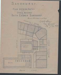
Document - PLAN OF BATH CORNER: SANDHURST 1879
Buff coloured plan showing Baths and other buildings at Bath Corner Sandhurst. Scale 50 Links to an Inch. Plan area Charing Cross, Mitchell Street and Bath Lane. Plan has bearings on it. Signed by G R B Steane, City Surveyor, 29th July 1879.place, building, commercial, plan of bath corner sandhurst 1879, charing cross, ladies' bath, g r b steane -
Bendigo Historical Society Inc.
Document - MARKS COLLECTION: PLAN BALCONY AND VERANDAH GEORGE LANSELL FORTUNA VILLA
Plan drawn in red and black ink on waxed paper. On top of plan 'Details of Balcony and Verandah for G. Lansell Esq' written in black pen cursive script. Other detail labelled 'Principal Cornice of Balcony'. On bottom of plan stamped in purple ink: Vahland & Getzschmann, Architects, Sandhurst'.bendigo, house, fortuna villa -
 University of Melbourne, Burnley Campus Archives
Plan, E.M. Gibson, Revised Roads Plan for Burnley Gardens, 1951
(1) 8 copies Plan by E.M. Gibson. (2) Report to Accompany Master Garden Plan for Burnley Gardens by E.M. Gibson 1.12.1949. Includes all areas around new Administration Building. Refers to help from C.R.T.S. students. Note: Master Garden Plan itself not found.e.m. gibson, burnley gardens, crts, students -
University of Melbourne, Burnley Campus Archives
Work on paper (item) - Student Work, E. Johnston, Mooney Residence Landscape Design, September 2017
Submitted as an assignment for an unspecified subject at Burnley Horticultural College, probably HORT90035 coordinated by Andrew Laidlaw. assignment, burnley horticultural college -
University of Melbourne, Burnley Campus Archives
Plan (item) - Plans Burnley Gardens, Department of Agriculture - Victoria Burnley Gardens
-
Glen Eira Historical Society
Frogmore Estate
... Plans ...A black and white photograph (140mm x 90mm) of a real estate advertisement for the sale of housing blocks on the residential development Frogmore Estate, Murrumbeena. The advertisement includes a plan showing the location of the housing blocks and the surrounding roads.murrumbeena, carnegie, frogmore estate, neerim road, gnarwyn road, coorigil road, moonya road, woornack road, rosstown railway, carool road, warina road, murrumbeena road, frogmore road, wahgoo road, hethersett grove, hethersett, thomas, j g, plans, housing estates, rosstown, caulfield council, land subdivision -
Bendigo Historical Society Inc.
Document - MARKS COLLECTION: PLAN OF SANDHURST CITY CENTRE AND SURROUNDING AREA ( NO. 1 )
Plan on heavy parchment - section neatly cut out of plan (area now Kennington) Written on plan in black print ' Sheet No. 1. Sandhurst'. Plan shows Government Camp, Commissioner's Gully, old cemetery site, manure depot, cattle market, Benevolent Asylum Reserve, railway reserve. Land owners' names on allotments. On bottom lithographed at the Department of Lands and Survey, Melbourne, by D. Henerson, March 12th., 1867 Plan part of George Lansell, Fortuna auction, documents found in wardrobe purchased by Marks family in 1930's.bendigo, planning, sandhurst 1867 -
 Melbourne Tram Museum
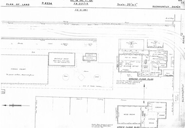
Drawing, Melbourne & Metropolitan Tramways Board (MMTB), "Glenhuntly Depot", c1937
Set of three photocopied plans or drawings on A3 sheet of "Glenhuntly Depot" - c 1938 .1 - P8334 - Plan of land showing details of offices and tennis court - 2-6-1938 .2 - P8335 - Plan of land showing car depot layout and associated buildings - 2-6-1938 - shows substation location. .3 - P8333 - Plan of land showing MMTB land and surrounding properties. - 2-6-1938trams, tramways, drawings, depots, property, glenhuntly tram depot, substation -
Port Melbourne Historical & Preservation Society
Document - Report, Ewan Ogilvy's Bayside Papers, Bayside EES Inquiry, Ewan Ogilvy's Bayside Papers, Box One, 1988
Ewan Ogilvy, former Melbourne Councillor and also of Community Services Victoria, Inner Urban Ministerial Advisory Committee and Uniting Church's Centre for Urban Research and Action (CURA), was instrumental in social justice approaches to town planning. He and CURA's Social Justice and the City Project funded Port Melbourne community groups protesting against the SCDC development in 1987. His files were presented to the Society in May 2001 on his preparation for leaving Victoria.From Ewan Ogilvy's chronologically organised 'Bayside Papers' relating to the proposed development of Port Melbourne industrial land in the late 1980s: EES Inquiry report to the Minister for Planning and Environment 7 April 1988, included in bound black file. Appendix 4: Bibliography; 7pp of documents and submissionsAll items signed 'Ewan Ogilvy'town planning, town planning - proposals shelved - bayside, public action campaigns, environmental issues, public housing, ewan ogilvy, centre for urban research and action, sandridge city development co pty ltd, scdc, linton r lethlean, judy arndt, francis b barnes -
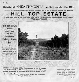 Ringwood and District Historical Society
Pamphlet, Atlas Press Pty. Ltd., Melbourne, Land Sale Brochure, Hill Top Estate, Heathmont, Vic. - circa 1925
Twelve page land sale brochure promoting Heathmont and Ringwood area including photographs, subdivision features and local facilities. Subdivision plan includes Heathmont Road, Balfour Avenue, Edith Street, Edna Street, and Great Ryrie Street. -
Port Melbourne Historical & Preservation Society
Plan - Town Hall, Sandridge, 1860s
Photos of Longitudinal, traverse, side and back elevation drawings for original Town Hall, Sandridge (No. 2); a record of appearance of .01 before treatment by conservators William Ireland:Witness Henry Bates:Reverse side: Plans of Town Hall, old and new. June 19th (pencil drawing)port melbourne town hall, built environment - civic -
 Port Melbourne Historical & Preservation Society
Plan - Town Hall, Sandridge, 1860s
Longitudinal, traverse, side and back elevation drawings for original Town Hall, Sandridge 1869 (No. 2) William Ireland:Witness Henry Bates:Reverse side: Plans of Town Hall, old and new. June 19th (pencil drawing)port melbourne town hall, built environment - civic, sandridge town hall -
 Melbourne Tram Museum
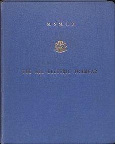
Document - Report, Melbourne & Metropolitan Tramways Board (MMTB), "The All-Electric Tramcar", 1961
Report - blue Rexene cloth heavy card covers, dark blue glued end sheets, fully sewn bound, with some 9 sections, with many sheets folded and appropriate paper spacing allowed for in the binding. Report titled "MMTB The ALL-ELECTRIC TRAMCAR" with MMTB logo in gold block on front cover and on the side of the report. About 150 pages. Report prepared by Frank R. Kirby Chief Engineer, December 1961. Has a table of Contents, Appendices, figures, tables and photographs. Report looks at the development of All Electric Tramcars in Europe and North America, the cost of maintenance of Melbourne's trams, operating costs, conductors, seated conductors, passenger handling, reliability, speeds, maintenance and capital costs.Has a lable on the first page, "Plan & EPA Library M0036918", Front cover stamped in red "Secretary's Files"trams, tramways, mmtb, pcc, germany, europe, all electric trams, prototype tramcar -
 Echuca Historical Society
Map, Map of Township - Echuca
Map on white paper that has yellowed. Black print Handwriting is black but faded. In wooden frame behind glass. Printed Survyor's plan for Echuca Township, date 5th March 1855, from the Surveyor General Office. Melbourne March 5th 1855 Plan drawn by P Chauncey. Hand written- This plan is now a Port for the South Australian Steamer Trade - when Hopwood settled here/ it was only a wild bush - he is now throwing a bridge/ at his own cost across this river 200yards wide. signed by Henry Hopwood. Typed on backing paper: Plan of the township of ECHUCA dated March 1855, One month before the first land sales / Autographed by Henry Hopwood in Oct 1955. -
 Federation University Historical Collection
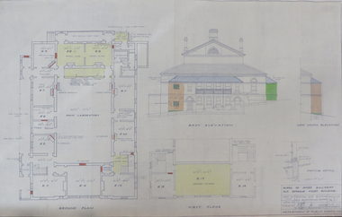
Plan, School of Mines Ballarat Old Supreme Court Building, 1959, 26/10/1959
Copy of a plan and elevations of the former Ballarat Supreme Court, later a building of the Ballarat School of Mines. The plans were for repairs and painting of the Old Electrical School of the Ballarat School of Mines. former ballarat supreme court, electrical school, ballarat school of mines, painting -
Port Melbourne Historical & Preservation Society
Map - MMBW, 1894
Melbourne and Metropolitan Board of Works 1894 Plans No. 338, 339, 355, 356 Segments shown: As plan No's: Bridge to Graham, Evans to Nott. (Large scale - 40'=1")311/H, 17engineering - board of works, built environment, education - primary schools, graham street state school, port melbourne primary school, business and traders - hotels -
 Coal Creek Community Park & Museum
Mine Map, 1942
6291.1 - Plan of "Austral Coal Mining Co" Lease in Korumburra detailing the mine tunnel plan, coal seam areas and some surface features such as railway sidings & Leura Creek. -
Bendigo Historical Society Inc.
Map - LEICHARDT, 23/05/1875
Map: Parish of Leichardt, County of Bendigo. Parish plan (coloured). Attached plan in the top left hand corner marked 'Building Lots' (number 323 in map cupboard 1)map, bendigo, building lots, leichardt -
Whitehorse Historical Society Inc.
Document, Forest Hill, 1/11/1992
Forest Hill Activity Centre Structure Plan Final Report. Prepared for City of Nunawading by Wilson Sayer Care Pty. Ltd. in association with Arup Transportation Planning November 1992.forest hill chase, wilson sayer core pty. ltd., arup transportation planning, shopping centres, city of nunawading, abbott, kevin -
 Whitehorse Historical Society Inc.
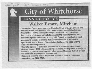
Document - Article, Planning Notice, 21/12/1998 12:00:00 AM
Planning Notice concerning the Walker Estate in Mitcham. Amendment to the Whitehorse Planning Scheme could include protection of buildings of historical significance, proposed early in 1999. Includes map of area.maps, walker estate, mitcham road, mitcham, calcutta street, mitcham, delhi street, mitcham, agra street, mitcham, simla street, mitcham, benares street, mitcham, meerut street, mitcham, the strand, mitcham, percy street, mitcham, stanley grove, mitcham, bray, dawn -
Bendigo Historical Society Inc.
Plan - MARKS COLLECTION: DOUBLE DISCHARGE GOLD MORTAR
Plan drawn on buff paper, written on plan double discharge gold mortar - no mine given. Engineering drawings of gold mortar. 3 inches = 1 foot, September 1879.mining, equipment, lansell mine ? -
University of Melbourne, Burnley Campus Archives
Plan - Sketch, Plan of Burnley Gardens, 1970-1980
Plans A and B. 2 identical hand drawn sketch plans of area bounded by manure bins, pumphouse to the east, milking shed and silo to the west: showing all buildings on the site.burnley gardens, buildings, burnley school of horticulture -
University of Melbourne, Burnley Campus Archives
Plan - Photocopy, Contour Map 1891, 1891
Photocopy of plan showing contour lines from Yarra River. Shows Pavilion and Principal's Residence but not much of the garden design. From Central Plan Office Dept. of Natural Resources.yarra river, pavilion -
Whitehorse Historical Society Inc.
Document, 520 Mitcham Road, 1/01/2008 12:00:00 AM
Documents relating to the Planning Permit Application for demolition of an existing dwelling and the development of 52 dwellings at 520-528 Mitcham Road Mitcham, January 2008.Documents relating to the Planning Permit Application for demolition of an existing dwelling and the development of 52 dwellings at 520-528 Mitcham Road Mitcham, January 2008. Contains: VCAT Finding 31 Jan 2008; VCAT Evidence Report by Coomes Consulting Group; Aboricultural statement by Treelogic Pty. Ltd.;Statement of expert design evidence by Hansen Partnership, engaged by the City of Whitehorse; Statement of town planning evidence prep. by Hansen Partnership; Urban design evidence prep. by Message Consultants; Report to VCAT [expert traffic evidence] by Cardno Grogan Richards; Draft conditions by Maddocks, Lawyers for City of Whitehorse; Report, John Patrick Landscape Architects.Documents relating to the Planning Permit Application for demolition of an existing dwelling and the development of 52 dwellings at 520-528 Mitcham Road Mitcham, January 2008. city of whitehorse, town planning, mitcham road, mitcham, no. 520-528 -
 Lara RSL Sub Branch
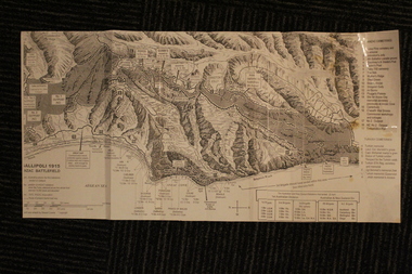
Group of Maps World War One, Group of Maps World War One - Dardanelles and Anzac Gallipoli Maps Circ 1915, Circ 1916
Gallipoli 1915 Maps and Naval plan of Operations World War One ANZACRare examples that explain both ANZAC and Naval Operations during World War One Gallipoli & Dardanelles Passage .!. Black and White Photocopy of Gallipoli 1915 ANZAC Battlefield - detailed positions of troops and Cemeteries. 2.The Allied Failure to Force The Dardanelles Passage 18 March 1915 - detailed line of Attack Naval Organisation, Mine layout, Plan of Attack (and copy).. 3. Map of Turkey and surrounding area written in Turkish and German Languages. C0olor version main roads and distances. (and copy).. 4. Map of ANZAC Trench Diagram. World War One.Color. (and copy). 5.Panorama of Chunuk Blair from 3 miles south of Nibrunesi Point, 3 November 1915 and Anzac from 1 mile N. E. of Ari Burnu, 21 November 1915. Black & White 6. Color Map of ANZAC positions with topographical Details, notes. 1. Artwork and copyright by Srewart Cownie, Gallipoli 1915 ANZAC Battlefield with Landings and later evacuation marked. 2. Details of Naval actions taken in the Dardanelles Passage 18 March 1918. 3. Local area Map or Turkey. Shows roads network and townships. 4. ANZAC Trench Diagram, copyright Whitcombe & Tombs Limited , Wellington N.Z. 1919 5. Panorama of two coast views of ANZAC area. Australian War Memorial, 6. Map of ANZAC positions of World War One, Gallipoli 1915. Published by H.E.C. Roberinson, George Street, Sydney N.S.W.18 April 1916maps operational of anzac and naval opations during 1915 etc, dardanelles naval opations