Showing 3980 items
matching surveys
-
 University of Melbourne, Burnley Campus Archives
Plan - Photocopy, Proposed Reserve for Horticultural and Experimental Garden in the Survey Paddock Richmond, 1862-1948
Photocopy of Plan Gazetted 01.08.1863. From Central Plan Office Department of Natural Resources.Signed by Clement Hodgkinson, Deputy Surveyor General. Stamped Department of Lands and Survey 7.12.48 Neg.18377. Handwritten notes on it, "Melb Roll 23 R.19(A)"exprimental gardens, burnley -
 Bendigo Military Museum
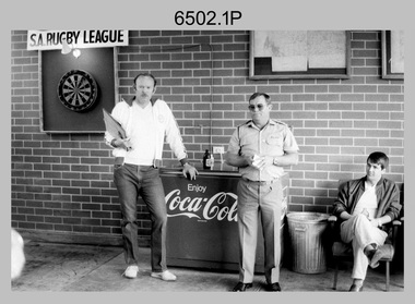
Photograph - 4th Field Survey Squadron – MAJ Don Taylor Farewell, Keswick Barracks, Adelaide SA, 1986
This is a set of 21 photographs of a 4th Field Survey Squadron function held in 1986 to farewell its OC MAJ Don Taylor. MAJ Taylor served 27 years in the Australian Regular Army from 1960 to 1987.This is a set of 21 photographs of a 4th Field Survey Squadron function to farewell its OC MAJ Don Taylor, at Keswick Barracks, Adelaide SA in 1986. The black & white photographs are on 35mm negative film and are part of the Army Survey Regiment’s Collection. The photographs were scanned at 96 dpi. .1) - Photo, black & white, 1986. L to R: SSM WO1 Bill Griggs, OC MAJ Don Taylor, unidentified. .2) - Photo, black & white, 1986. Back row L to R: SGT Wally Chilcott, unidentified (x2), CPL Peter McCurdy, unidentified. Front row L to R: LT Greg Oaten CSC, LT Malcolm Hentschel, SPR Steve Nokes. At front L to R: CPL John Ratcliffe, OC MAJ Don Taylor, SSM WO1 Bill Griggs. .3) - Photo, black & white, 1986. L to R: SSM WO1 Bill Griggs, CPL John Ratcliffe, OC MAJ Don Taylor, George Ricketts, unidentified (x2). .4) - Photo, black & white, 1986. L to R: LT Malcolm Hentschel, unidentified (x2), CPL John Ratcliffe, CPL Peter Hardy, SSM WO1 Bill Griggs, OC MAJ Don Taylor. .5) - Photo, black & white, 1986. L to R: LT Greg Oaten CSC, LT Malcolm Hentschel, unidentified (x2), CPL John Ratcliffe, CPL Peter Hardy, SSM WO1 Bill Griggs, OC MAJ Don Taylor. .6) - Photo, black & white, 1986. L to R: SGT Bill Tewson, SGT Bob Croxton, CPL Dave Irving, WO2 Bob Rogister, unidentified (x3), SSGT Cam Chapman, Chris Hills, CPL Roger Graf. .7) - Photo, black & white, 1986. L to R: SSM WO1 Bill Griggs, LT Malcolm Hentschel, OC MAJ Don Taylor, SGT Mick Hogan. .8) - Photo, black & white, 1986. L to R: unidentified, LT Malcolm Hentschel, SSM WO1 Bill Griggs, Mick Hogan’s daughter? OC MAJ Don Taylor, SGT Mick Hogan. .9) - Photo, black & white, 1986. L to R: unidentified, SSM WO1 Bill Griggs, unidentified, SGT Bill Tewson, OC MAJ Don Taylor. .10) - Photo, black & white, 1986. L to R: unidentified, SGT Bill Tewson, SSM WO1 Bill Griggs, OC MAJ Don Taylor, SGT Mick Hogan and his wife. .11) - Photo, black & white, 1986. L to R: CAPT Steve Cooper, SSM WO1 Bill Griggs, OC MAJ Don Taylor. .12) - Photo, black & white, 1986. L to R: unidentified, CAPT Steve Cooper, SSM WO1 Bill Griggs, OC MAJ Don Taylor, SGT Mick Hogan. .13) - Photo, black & white, 1986. L to R: unidentified, CPL Peter McCurdy, SGT Bill Tewson, CAPT Steve Cooper, OC MAJ Don Taylor, SSM WO1 Bill Griggs. .14) - Photo, black & white, 1986. L to R: OC MAJ Don Taylor, unidentified (x5), CPL Chris ‘Charlie’ Brown, unidentified (seated), SPR Damian Killeen, remainder unidentified. .15) - Photo, black & white, 1986. L to R: unidentified, LT Malcolm Hentschel, SPR Steve Ellis, unidentified (x5), CPL Roger Graf. .16) - Photo, black & white, 1986. Unidentified personnel. SPR Richard Cocker takes aim at the dart board. 4 Fd Svy Sqn Farewell 1986. .20) - L to R: unidentified, CPL Peter Hardy, CPL Tracey (Beckwith) Phillips, unidentified (x4), CAPT Steve Cooper, Ken Jeffery, remainder unidentified. .21) - L to R: CPL C. Rimmington, SGT H. Young. .17) - Photo, black & white, 1986. L to R: SPR Steve Nokes, LT Greg Oaten CSC, SPR Simon Reynolds, Chris Hills, LT Malcolm Hentschel, SGT Wally Chilcott. .18) - Photo, black & white, 1986. L to R: unidentified, SPR Richard Cocker, CPL Peter McCurdy, LT Greg Oaten CSC, SPR Simon Reynolds, SGT Bob Croxton. .19) - Photo, black & white, 1986. L to R: CPL Chris ‘Charlie’ Brown, Mrs Kath Rogister, WO2 Bob Rogister, SSGT Cam Chapman, CAPT Terry Lord, unidentified. .20) - Photo, black & white, 1986. L to R: unidentified, CPL Peter Hardy, CPL Tracey (Beckwith) Phillips, unidentified (x4), CAPT Steve Cooper, Ken Jeffery, remainder unidentified. .21) - Photo, black & white, 1986. L to R: CPL C. Rimmington, SGT H. ’Jock’ Young..1P to .21P – There are no personnel identified. ‘MAJ Don Taylor’s SQN Farewell. 1986’ annotated on negatives sleeve.royal australian survey corps, rasvy, 4 fd svy sqn -
 Federation University Historical Collection
Book, Mining Engineers Handbook Volume 1 & 2, 1941
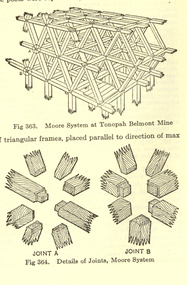
The book was used by Charles Bacon who studied at the University of Nevada in the late 1930s/early 1940s. Bacon worked at Bunker Hill Mines and Kellogg Idaho, before arriving in Australian in 1951. He worked for CN Myers, a company involved with paper converting. CN Myers was a family business (on Charles Bacon's maternal line). Robert Peele was Professor Emeritus of mining Engineering at the School of Mines, Columbia University.Maroon hardcovered books. .1) Volume 1 - Chapters include Mineralogy, Geology and Mineral Deposits, Earth Excavation, Explosives, Rock Excavation, Tunneling, Shaft Sinking in Rock, Shaft sinking in Unstable and Waterbearing Ground, Boring, Underground Transport, Mine Ventilation. .2) Volume 2 - Chapers include Compressed Air Practice, Electric Power for mine Service, Surveying,Underground Surveying, Mine Geologic Maps and models, Cost of mining, Mining Laws, Ore sampling, Assaying, Aerial Tramways and Cableways, Gold Amalgamation and Cyanidation, etc.Inside front cover "Charles Bacon"charles bacon, mining engineering, mining, engineering, university of nevada, mackay school of mines, explosives, timbering -
 Bendigo Historical Society Inc.
Map - FORTUNA HUSTLER'S MINE - LONGITUDINAL SECTION OF THE FORTUNA HUSTLER'S MINE
Longitudinal Section of the Fortuna Hustler's Mine on the Hustler's Line of Reef, Bendigo. Bulletin No 33, Plate No IV. Shows poppet legs at the surface level, Datum Line 750 feet above Sea Level, levels and their depths, the amount of gold per ton and some geographical features. Geological Survey of Victoria emblem and signed by H A Whitelaw, Underground Survey Office, Bendigo. Note - Plates 4, 8, 13, 20, 26 & 31 form a Longitudinal Section from Fortuna Hustler's to Hustler's Consols Mine. This item has not been scanned or photographed.mining, parish map, fortuna hustler's mine, longitudinal section of the fortuna hustler's mine, geological survey of victoria, h a whitelaw, underground survey office bendigo, hustler's line of reef, hustler's consols mine -
Bendigo Historical Society Inc.
Map - HUSTLER'S REEF MINE - TRANSVERSE SECTION OF THE HUSTLER'S REEF MINE
Transverse Section of the Hustler's Reef Mine on the Hustler's Line of Reefs. Bulletin No 33, Plate No XVIII. Shows cross-cuts and their depth, different types of stone and geological features encountered. Drawing of poppet legs at the surface and Sill of Shaft 756.39 ft above Sea Level. Reference Table shows key to the different stone and geographical features encountered. Geographical Survey of Victoria. Signed by H A Whitelaw, Underground Survey Office, Bendigo, September 1913. Thompson's Reef is also mentioned on the map. This item has not been scanned or photographed.mining, parish map, hustler's reef mine, transverse section of the hustler's reef mine, geological survey of victoria, h a whitelaw, underground survey office bendigo, thompson's reef. -
Bendigo Historical Society Inc.
Map - HUSTLER'S REEF & HUSTLER'S REEF NO 1 MINES - LONGITUDINAL SECTION OF THE HUSTLER'S REEF & HUSTLER'S
Longitudinal Section of the Hustler's Reef & Hustler's Reef No 1 Mines on the Hustler's Line of Reef. Bulletin No 33, Plate No XX. Note - Plates 4, 8, 13, 20, 26 & 31 form a Longitudinal Section from Fortuna Hustler's to Hustler's Consols Mine. Geological Survey of Victoria emblem. Signed by H A Whitelaw, Underground Survey Office Bendigo, September 1913. Shows the two shafts with their levels and depths. Also shows geographical features and yields of gold and amalgam per ton. This item has not been scanned or photographed.mining, parish map, hustler's reef & hustler's reef no 1 mines, longitudinal section of the hustler's reef & hustler's reef no 1 mines, geographical survey of victoria, underground survey office bendigo, h a whitelaw -
Bendigo Historical Society Inc.
Map - HUSTLER'S REEF & HUSTLER'S REEF NO 1 MINES - PLAN OF THE HUSTLER'S REEF & HUSTLER'S REEF NO 1 MINES
Plan of the Hustler's Reef & Hustler's Reef No 1 Mines on the Hustler's Line of Reefs Bulletin No 33, Plate No XV. Plan shows the two mines with depth of levels, geological features and levels in relation to the shaft. Geological Survey of Victoria emblem and signed by H A Whitelaw, Underground Survey Office Bendigo, September 1913. Note - The Lease Boundaries shown on this plan are only in their approximate relative positions to Nos 13, Intermediate and 14 Levels of the Hustler's Reef No 1 workings, and Nos 15, 16 and 17 Levels of the Hustler's Reef workings.mining, parish map, hustler's reef & hustler's reef no 1 mines, plan of the hustler's reef & hustler's reef no 1 mines, geological survey of victoria, underground survey office bendigo, h a whitelaw, hustler's line of reefs -
Bendigo Historical Society Inc.
Map - HUSTLER'S REEF NO 1 MINE - TRANSVERSE SECTION OF THE HUSTLER'S REEF NO 1 MINE
Map of a transverse Section of the Hustler's Reef No 1 Mine on the hustler's Line of Reefs Bulletin No 33, Plate No XXI. Map shows poppet legs at 801.07 feet above Sea Level and drawing of shaft with the different levels. Also shown are geological features and stone encountered. Geological Survey of Victoria emblem H Herman, Director, W Dickson, Secretary of Mines and The Hon. J. Drysdale Brown MLC Minister of Mines. Signed by H S Whitelaw, Underground Survey Office Bendigo, September, 1913. This item has not been scanned or photographed.mining, parish map, hustler's reef no 1 mine, hustler's line of reefs, transverse section of the hustler's reef no 1 mine, geological survey of victoria, underground survey office bendigo, h s whitelaw, h herman, w dickson, the hon j drysdale brown -
Bendigo Historical Society Inc.
Map - HUSTLER'S ROYAL RESERVE NO 2 CO - TRANSVERSE SECTION OF THE HUSTLER'S ROYAL RESERVE NO 2 CO
Transverse Section of the Hustler's Royal Reserve No 2 Co Mine on the Hustler's Line of Reef Bendigo, Bulletin No 33, Plate No VII. Section shows the poppet legs and the sill of Shaft at 707.65 ft above sea level, depth of levels, stone encountered and geological features. Geological Survey of Victoria emblem. H. Herman Director, W. Dickson Secretary of Mines and The Hon. J. Drysdale Brown MLC, Minister of Mines. Signed by H S Whitelaw, Underground Survey Office Bendigo, September 1913. This item has not been scanned or photographed.mining, parish map, hustler's royal reserve no 2 co, transverse section of the hustler's royal reserve no 2 co, h s whitelaw, undergrou;nd survey office bendigo, geological survey of victoria, h herman, w dickson, the hon. j drysdale brown mlc -
Bendigo Historical Society Inc.
Map - HUSTLER'S ROYAL RESERVE NO 2 (PARK SHAFT.) - TRANSVERSE SECTION OF THE HUSTLER'S ROYAL RESERVE NO 2
Transverse section of the Hustler's Royal Reserve, No 2 (Park Shaft.) on the Hustler's Line of Reef. Bulletin No 33, Plate No IX. Section shows poppet legs and sill of shaft at 755.70 ft above sea level, depth of levels, type of stone encountered including lava and geological features. Geological Survey of Victoria emblem and beneath it H. Herman, Director, W. Dickson, Secretary of Mines and The Hon. J. Drysdale Brown MLC Minister of Mines and signed by H S Whitelaw, Underground Survey Office, Bendigo September, 1913.mining, parish map, hustler's royal reserve no 2 (park shaft.), transverse section of the hustler's royal reserve no 2 (park shaft.), h s whitelaw, underground survey office bendigo, geological survey of victoria, h herman, w dickson, the hon j drysdale brown mlc, hustler's line of reef -
 Bendigo Military Museum
Manual - Manual of Photogrammetry, (Preliminary Edition), 1934 American Society of Photogrammetry, Circa 1934
This book belonged to Brigadier FD Buckland OBE Director of Survey Land HeadquarterHardcover, light blue, 819 pages, text, diagrams, photographsroyal australian survey corps, rasvy, fortuna, army survey regiment, army svy regt, asr, photogrammetry -
 Federation University Historical Collection
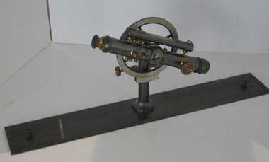
Instrument - Surveyor's Instrument, Boxed Theodolite, c late 1880s
According to Max Clarke this item was used by the surveying classes at the Ballarat School of MinesA boxed (timber) theodolite with crossbars and full-length stadia wires. The theodolite can be mounted on a metal straightedge base. The box also contains a magnetic compass with two bubble levels, a plumbing folk, and 4 brass paper clips designed to suit a plan table. On box in black paint "A 1". Inside box lid is manufacturer's label and Stadia measurement zero reference calibration.ballarat school of mines, surveying equipment, gurley, max clarke, theodolite, stadia measurement, calibration, scientific instrument -
Federation University Historical Collection
Book, Jacobs Lewis Vines Architects and Conservation Planners, Historic Sites Survey: Ballarat Study Area, 1980, 1980
This survey was commissioned by the Land Conservation Council, Australian Heritage Commission and the Ministry for Conservation 114 page report on historic sites in the Ballarat region. It includes information on sites, a schexdule of sites, silte selection and designated areas (ie around towns)historic sites, ballarat, wendy jacobs, miles lewis, gary vines, berringa, buninyong, creswick, dunnstown, fiery creek, lal lal, langi logan, cathcart, mount cole, mount egerton, nerrina, gong gong, wombat state forest, railways, explorers routes, early roads, land conservation council, ausralian hertiage commission, department of planning, icomos (burra) charter, nigel lewis, richard aitken, freehold land, public land, langi ghiran, new jubille mine, birthday tunnel mine, pitfield plains, smythesdale, buninyong company, mount clear, mt clear, canadian gully, warrenheip distillery, thomas mitchell, waterloo, trawalla, beaufort, raglan, internment camps, forestry, mining, mining, mt egerton, mary hollick collection, jubilee mine, burra charter, historica areas data form, explorers, egerton company, black horse mine, mt egerton government battery, kaolin mines, anderson brothers, barkstead, anderson's tramway, clarkesdale, berry leads, birthday tunnel mine berringa, warrenheip, australasian company, mount mercer, lanvi-kal-kal, water race -
Moorabbin Air Museum
Document (Item) - Field Service Surveys Sabre 544
Description: Field Service Surveys (Defect Reports) Sabre 540 Level of Importance: . -
Moorabbin Air Museum
Document (Item) - Field Service Surveys Sabre 545
Description: Field Service Surveys (Defect Reports) Sabre 544 Level of Importance: . -
Moorabbin Air Museum
Archive (Item) - Flight Test Reports Sabre 944-950
Description: Field Service Surveys (Defect Reports) Sabre 545 Level of Importance: . TIDS -
Moorabbin Air Museum
Document (Item) - Mirage Wing Sets - Pre Installation Tested - Serial Nos 1-111 Inspection Cards
Description: Field Service Surveys (Defect Reports) Sabre 580 Level of Importance: . -
 Peterborough History Group
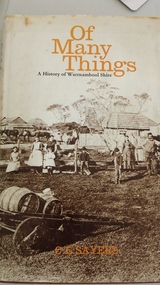
Book, C.E.Sayers, Of Many Things, 1972
Book contains information about early Peterborough: survey and settlers, schools and wrecks.Provides insight into the early formation of the township of Peterborough and its terrain.Hardcover 188 page book with indexInscription "donated by Barry Jenkins"peterborough history, irvine family, peterborough school, shipwrecks, shipwreck coast, great ocean road, warrnambool, peterborough shipwreck -
 Ballarat Heritage Services
digital copy, Surveyor's Notebook Ballarat East, 24 August 1858
Survey of land in Ballarat East in August 1858 showing hotels and tents etc. Images from Bellair's surveyor's book.eugene bellair, surveying, surveyor, eureka stockade -
Ringwood and District Historical Society
Envelope, Packet: Depression in the 1930s - Ringwood area clippings, Letters; Hugh Anderson Publication (Hill of Content series)
Depression of the 1930s - 10 pages newspaper cuttings; Letters from Dept Public Works, State Relief Committee, Ringwood Football Association, Boys Employment Movement, Youth Employment Survey; Australia in the Depression - Hill of Content Archive Series -
 Federation University Historical Collection
Booklet, Waller & Chester, City of Ballarat, 09/1970
Ballarat became a city in 1870. The special centenary meeting was held on Wednesday 9 September 1970Large white soft covered booklet including the notice programme for the centenary meeting of the City of Ballarat. It includes a City of Ballarat Logo, meeting agenda, and images of Sturt Street, central portion of the City, and the first survey of the Ballarat Township (1852).ballarat, council, centenary, james oddie, ballarat east, ballarat town hall, muncipal, kenneth webb, town clerks, urquhart's survey -
Bendigo Historical Society Inc.
Map - RAVENSWOOD : COUNTY OF BENDIGO, 28-7-14
Map. Ravenswood, County of Bendigo, County of Talbot, Lockwood, Sutton Grange, Harcourt, Walmer, Bradford, Shelbourne, Mandurang, Photo-Lithographed at the Department of Lands and Survey by T.F. McGauran 28-7-14. (number 86 in map cupboard 1)T.F. McGauranmap, bendigo, ravenswood -
Bendigo Historical Society Inc.
Map - CAMPBELL COLLECTION: BENDIGO & DISTRICT MAPS, 22-3 29
Map. Marong, Parishes of Marong, Lockwood and Mandurang. Scale 20 chains to an inch. Total area 5106 acres. Crusoe Reservoir on right. Compiled in W.P.B. from Field Survey and Parish Plans (number 373 in map cupboard 1)G.W.Lmap, bendigo, allotments -
Bendigo Historical Society Inc.
Map - CAMPBELL COLLECTION: BENDIGO AND DISTRICT MAPS
Map. Marong, Parishes of Marong, Lockwood and Mandurang. Scale 20 chains to an inch. Total 5106 acres. Compiled in W.P.B. from Field Survey and Parish Plans. Crusoe Reservoir to the right of map. (number 362 in map cupboard 1)map, bendigo, parish plan -
Bendigo Historical Society Inc.
Book - DEPARTMENT OF MINES 1914 BULLETINS OF THE GEOLOGICAL SURVEY OF VICTORIA NO. 33. HUSTLER'S LINE OF REEF, BENDIGO, 1914
Department of Mines 1914 Bulletins of the Geological Survey of Victoria No. 33. Hustler's Line of Reef, Bendigo. Photos of the mines on the Hustler's Line of Reef. 59 pages plus 7 pages of photos. Inscribed A. Richardson 29 Harrison street, BendigoDepartment of Mines.bendigo, mining, hustler's line of reef, mining, and hustler's reef mines. -
Bendigo Historical Society Inc.
Map - ROCHESTER WEST : COUNTY OF BENDIGO, 30-10-12
Map. Rochester West, County of Bendigo, Ballendella, Giggorra, Township of Rochester. Campaspe River. Photo-lithographed at the Department of Lands and Survey, Melbourne, by W.J. Butson 30-10-12. Price 1/-. (number 22 in map cupboard 1)W.J. Butson, Government Printer.map, bendigo, rochester west -
 Bendigo Historical Society Inc.
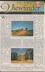
Newspaper - JACK PERRY COLLECTION: NEWSPAPER LIGHTNING HILL
Newspaper article, Bendigo Weekly, on Lightning Hill and Permanent Survey Markers, their importance in mapping, drainage and sewerage planning. Marker on Lightning Hill shows distance and direction to Mr. Ida Heathcote, Pyramid Hill, Mt. Moliagul and Mt. Korong.person, individual, jack perry, lightning hill, permanent survey markers, windmill hill -
Bendigo Historical Society Inc.
Map - YALLOOK : COUNTY OF BENDIGO, 1957
Map. Yallook, County of Bendigo,Talambe, Tandarra, Neilborough, Yarraberb, Salisbury, Pompapiel. Drawn and reproduced at the Department of Lands and Survey, Melbourne.1957. Price 2/-. By authority W.M. Houston, Government Printer. (number 11 in map cupboard 1)W.M Houston, Government Printermap, bendigo, yallook -
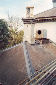 Villa Alba Museum
Photograph - Villa Alba roof, chimney & chimney pots, c.1987
Built for William and Anna-Maria Greenlaw in the early 1880s, and with interiors decorated by the Paterson Bros, Villa Alba remained in private ownership until 1949. From 1950, the house was owned by a number of institutions. By 1984, the Villa Alba Preservation Society had been formed, and three years later, the Mount Royal Hospital granted a 25-year lease to Kew Council. In 2004, the title to Villa Alba was passed by the Victorian Government to The Villa Alba Museum Incorporated. The Museum, at 44 Walmer Street, Kew, is now a cultural institution committed to the collection, study and display of 19th century interior decorative finishes, and the components of 19th and 20th century interior decoration.This is one of a number of historically and aesthetically significant photos of the interiors and exterior of Villa Alba when it was still owned by the Mount Royal Hospital, showing twentieth century accretions and deterioration of the historic fabric of the building. This was a benchmark survey against which future conservation and restoration activities can be measured.In December 1987, Mockridge Stahle & Mitchell Pty Ltd Architects prepared ‘Villa Alba Survey: A Report on the fabric for Mount Royal Hospital’ of which this photograph is a part. Photo of Villa Alba rear slate roof, chimney & chimney potsvilla alba museum, conservation photographs, victorian architecture, slate roofs -
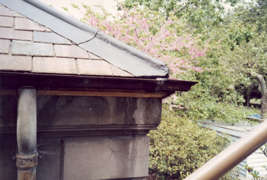 Villa Alba Museum
Photograph - Corner of slate roof with downpipes, c.1987
Built for William and Anna-Maria Greenlaw in the early 1880s, and with interiors decorated by the Paterson Bros, Villa Alba remained in private ownership until 1949. From 1950, the house was owned by a number of institutions. By 1984, the Villa Alba Preservation Society had been formed, and three years later, the Mount Royal Hospital granted a 25-year lease to Kew Council. In 2004, the title to Villa Alba was passed by the Victorian Government to The Villa Alba Museum Incorporated. The Museum, at 44 Walmer Street, Kew, is now a cultural institution committed to the collection, study and display of 19th century interior decorative finishes, and the components of 19th and 20th century interior decoration.This is one of a number of historically and aesthetically significant photos of the interiors and exterior of Villa Alba when it was still owned by the Mount Royal Hospital, showing twentieth century accretions and deterioration of the historic fabric of the building. This was a benchmark survey against which future conservation and restoration activities can be measured.In December 1987, Mockridge Stahle & Mitchell Pty Ltd Architects prepared ‘Villa Alba Survey: A Report on the fabric for Mount Royal Hospital’ of which this photograph is a part. Photo of exterior of Villa Alba showing corner of slate roof with downpipes.villa alba museum, conservation photographs, victorian architecture, etched glass, slate roofs, victorian downpipes