Showing 177039 items matching "27-schutt-street"
-
 Stawell Historical Society Inc
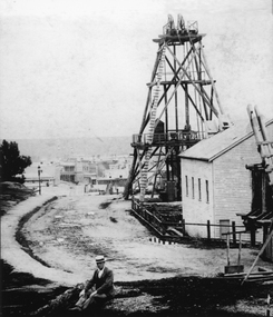
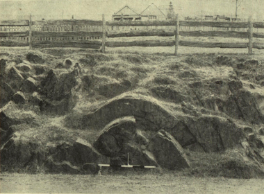
Photograph, Sloane's & Scotchman Mining Co Poppet Head in Upper Main Street Big Hill looking West. c1890
Gentleman sitting in front of Sloane's & Scotchman Mining Co Poppet Head Upper Main Street Big Hill looking West. Main Street visible in distance background.Poppet head above shaft and engine shed at right. Looking towards corner of Main and Lazelle Streets. Man seated at front centre of photo in boater hat.stawell mining, streetscape -
 Ringwood and District Historical Society
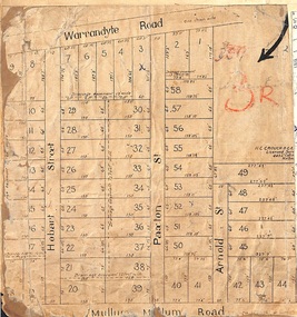
Map, Residential Subdivision Allotment Layout on Mullum Mullum Road, Hobart Street, Paxton Street, Arnold Street and Warrandyte Road, Ringwood, Vic. circa 1920
One of 3 unrelated land subdivision maps on cardboard backing.H.C. Crouch, Licensed Surveyor, 443 Lt Collins Street, Melbourne. -
 Lara RSL Sub Branch
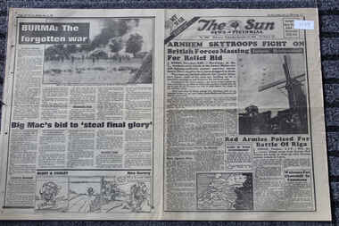
Newspaper - The Sun Newspaper dated 27/9/1944, Arnhem Skytroopers Fight On For Relief Bid - Red Army Poised For Battle of Riga - Burma: The Forgotten War
The Sun Newspaper dated 27/9/1944The Sun Newspaper dated 27/9/1944The Sun Newspaper dated 27/9/1944Arnhem Skytroopers Fight On For Relief Bid - Red Army Poised For Battle of Riga - Burma: The Forgotten Wararnhem skytroopers fight on for relief bid - red army poised for battle of riga - burma: the forgotten war -
 Ballarat Heritage Services
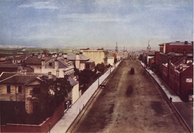
Photograph - Image, Collins Street, Melbourne, from Spring Street, 1870
A colour image of Collins Street, Melbourne.melbourne, collins street, streetscape -
 Ballarat Heritage Services
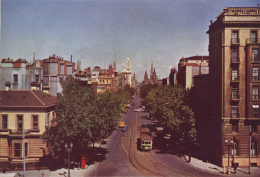
Photograph - Image, Collins Street, Melbourne, from Spring Street, 1951
The Shamrock began life in 1854, as a small hotel known as The Exchange Hotel, servicing miners during the Victorian gold rush/A colour image of Collins Street, Melbourne.melbourne, collins street, streetscape -
 Ballarat Heritage Services
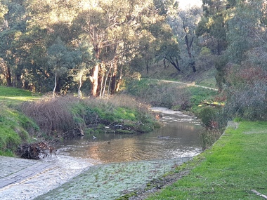
Photograph, Clare Gervasoni, Yarrowee Channel Near Hill Street, Ballarat, 27/06/2021
Photographs of the channelled and unchanneled Yarrowee River near Hill Street and Redan. Ut shows were the channel ends.yarrowee river, yarrowee creek, yarrowee channnel, bluestone channel, bluestone -
 Linton and District Historical Society Inc
Photograph, Linton Pioneer Memorial Cairn in Sussex Street, Linton
A memorial cairn honouring the early pioneers of Linton was erected in Sussex Street in 1939.A sepia photograph of Linton pioneer memorial cairn in Sussex Street, old blacksmith's shop (Ball's) in background, also Mrs Blamire's home.On back -"Linton pioneer memorial cairn. There used to be a row of huge gum trees along excavation for memorial. Old blacksmiths shop in background, also Mrs Blamire's home. Mrs McCorkill's house must have been brought in."sussex street, memorials, blamire, blacksmith's shop -
 Kilmore Historical Society
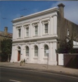
Photograph, 39 Sydney Street, 1980's?
Was the site of the Old Colonial Bank of Australasia Ltd.9.5cm x 10cm coloured photograph of the building at 39 Sydney Street. The double story building has an ornate light-coloured facade, which darker brickwork on the sides. Arched windows on the ground floor and rectangle window with trim on the top floor. Signage on the building states "Dornal Antiques". There is also a planter out the front on the footpath.storefront, shopfront, antiques, antique dealers, retail stores -
 Kilmore Historical Society
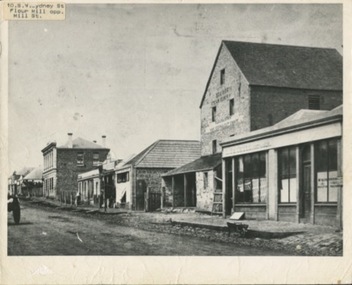
Photograph, SW Sydeny Street, 1860
25cm x 20 cm black and white photograph mounted on board. The photograph is taken at an angle so you can see multiple buildings on the western side of Sydney Street including: Trainor's Steam Flour Mill, Parnells Boot Shop, Quinn Solicitor, Youngs Bakery and Post Office and Royal Oak Hotel in the distance.Written on the back: #10 Trainor's Steam Flour Mill, Parnell's Bootshop, Quinn Solicitor, Young's Bakery + Post Office #3.#5.10/86-38A Copy of Sydney St. Kilmore 1860 Trainors Mill (opposite present Mill St) Royal Oak Hotel in distance.post office, flour mill, bakery, bootmaker -
 Port Melbourne Historical & Preservation Society
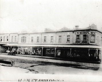
Photograph, Market Buildings, c.1915
The group of buildings running down Bay Street from Liardet Street were know as the Market Buildings. On the corner was I & S BURNS No 1 Cash Grocer. Part of this site is currently occupied by Coles Port Melbourne supermarket.Photograph of the Market Buildings in Bay Street running down from Liardet Street. At the top of the corner building it reads I & S Burns No 1 Cash Grocers.On reverse 'Market Buildings PM L Cou..... Bay Street Cr Liardett Street'market buildings, built environment - commercial, business and traders - grocers and supermarkets, coles supermarket, i & s burns no 1 cash grocer, i & s burns -
 Eltham District Historical Society Inc
Photograph, First house in Pryor Street, Eltham, c.1965, 1965c
This was the first house on Pryor Street which was located at the corner of what is now Commercial Place on the eastern side. Originally there was another house adjacent but it had been moved by the time of the 1951 aerial survey. The house was also the first home of Russell Yeoman who had been newly appointed to the Shire of Eltham and this house belonging to the council was vacant and made available to him for four weeks before it was relocated to Susan Street just south of the bowls club and was used a child care centre associated with the Living and Learning Centre (Russell believes). Russell then moved into another council owned house at the corner of Susan and Bridge Streets.Digital file only; created from original colour positive slide transparencyeltham, streets, houses, pryor street, susan street, fe holden sedan, russell yeoman collection -
 Eltham District Historical Society Inc
Photograph, First house in Pryor Street, Eltham, c.1965, 1965c
This was the first house on Pryor Street which was located at the corner of what is now Commercial Place on the eastern side. Originally there was another house adjacent but it had been moved by the time of the 1951 aerial survey. The house was also the first home of Russell Yeoman who had been newly appointed to the Shire of Eltham and this house belonging to the council was vacant and made available to him for four weeks before it was relocated to Susan Street just south of the bowls club and was used a child care centre associated with the Living and Learning Centre (Russell believes). Russell then moved into another council owned house at the corner of Susan and Bridge Streets.Digital file only; created from original colour positive slide transparencyeltham, streets, houses, pryor street, susan street, russell yeoman collection, fc holden sedan -
 Tatura Irrigation & Wartime Camps Museum
Photograph, Tom Flanagan's House, Hogan Street Tatura
Shows Tom Flanagan's house in Hogan Street looking east along Hogan Street. Shows Dave and Grace Howarth's Milk Bar. Colour photograph showing Tom Flanagan's house in Hogan Street, Tatura, looking east towardsDave and Grace Howarth's Milk Bar. Photograph stuck onto piece of white cardboard. hogan street tatura, tatura businesses, ross street tatura, tom flanagan, grace howarth, dave howarth, howarth milk bar tatura -
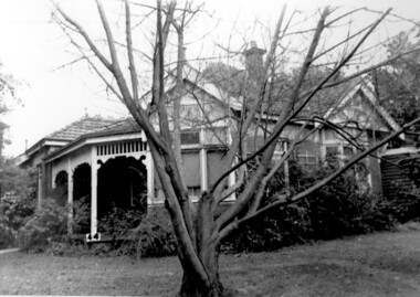 Surrey Hills Historical Society Collection
Digital photo, 'Pymble', 2 Earle Street, Mont Albert
Pymble’, 2 Earle Street was built in 1907 with additions in 1915. It was the home of Alan and Edna Holt and family from 1958-1966. Alan Judge Holt was Secretary of the Lands Department of Victoria during his working life. He was a keen and meticulous local historian, whose work contributed significantly to this collection. The house is extant in 2020, but Earle Street is now Earle Close.A black and white photograph of a Queen Anne style house. There are a couple of bay windows and a verandah using timber fretwork.pymble, house names, earle street, mont albert, mr alan holt, mrs edna holt, queen anne style -
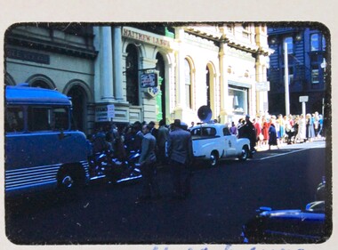 Melbourne Legacy
Slide, Legacy House in Market Street, 1957
A slide image of the old Legacy House in Market Street from 1957. It shows children and people gathered to go on an outing to the sea known for many years as Operation Float. Legacy rented the Market St premises for many years. A small 'Legacy House' sign can just be seen between the bus and the sign post. It was part of the Western Market complex that was demolished and redeveloped in the early 1960s. Legacy held meeting and the girls classes on the second floor of the building but it was barely fit for purpose. In the 1940s a generous donation by an anonymous donor meant Legacy could purchase a building at 342 Swanston St, but due to several factors were never able to inhabit it. Finally it was sold in 1954 and Junior Legacy Melbourne purchased 289-299 Swanston Street Melbourne (previously called Red Cross House) in 1956 from the Commonwealth Government. As part of the conditions of the donation it was named in memory of David H Dureau. Renovations were needed to the 289-299 Swanston St building so this slide shows that Legacy were still in the Market St building in 1957 while they occurred. A record of the Market Street building that Legacy occupied for many years until 1956-7.Colour slide of Legacy House in Market Street from 1957.Slides has 'Que for Operation Float looking up Market St'. It is numbered '14' by the manufacturer.properties, market st, streetscape -
 Whitehorse Historical Society Inc.
Document, Alterations to be made in Street Names, 1932
List of alterations to be made in street namesList of alterations to be made in street names - Shire of Blackburn and Mitcham from Shire Secretary to Chief Draughtsman of Titles, Melbourne, 15 Jul 1932. stating that the finalisation of the alteration of 'West India Avenue', Tunstall and 'West Avenue' will both be known as Milton Street.List of alterations to be made in street names street names, shire of blackburn and mitcham -
 Eltham District Historical Society Inc
Photograph, Peter Pidgeon, 68 Bible Street, Eltham, 15 March 2018, 15/3/2018
At the corner with York Street. Originally built c.1880 but modified later, the house was bulldozed on 19-20 October 2017 Born digital image (2)eltham, streets, houses, bible street -
 Eltham District Historical Society Inc
Photograph, Liz Pidgeon, 68 Bible Street, Eltham, 22 September 2017, 22/9/2017
At the corner with York Street. Originally built c.1880 but modified later, the house was bulldozed on 19-20 October 2017Born Digitalbible street, houses, streets, eltham -
 Eltham District Historical Society Inc
Photograph, Liz Pidgeon, 68 Bible Street, Eltham, 25 October 2017, 22/9/2017
At the corner with York Street. Originally built c.1880 but modified later, the house was bulldozed on 19-20 October 2017Born Digitalbible street, houses, streets, eltham -
 Eltham District Historical Society Inc
Photograph, Peter Pidgeon, 68 Bible Street, Eltham, 30 October 2017, 30/10/2017
At the corner with York Street. Originally built c.1880 but modified later, the house was bulldozed on 19-20 October 2017Born Digitalbible street, houses, streets, eltham -
 Eltham District Historical Society Inc
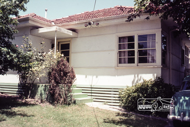
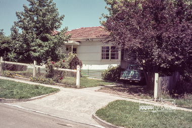
Photograph, Margaret Ball, 32 Pryor Street, Eltham, June 1999, 1999
Owner: Mr and Mrs Warren Snr, parents of H.E. Warren of 30 Pryor Street. Sold 17 March 2001The Margaret Ball (Pre 1960s Houses) Collection was a personal project initiated to mark the year 2000 and arose as a result of the disappearance of many pre-1960s parts of Eltham due to development. Approximately 200 pre-1960s style houses that were left in Eltham between Main Road and east to Bible Street, between Cecil Street to the north and south to Dalton Street were photographed in late 1999. Not all of the houses could be photographed; some because the garden or trees blocked the view of the house, others because of rubbish or cars were in the way, some because people were working on the house or in the gardens at the time.Roll of 35mm colour negative film, 10 stripsFuji 200eltham, houses, streets, margaret ball (pre 1960s houses) collection, pryor street -
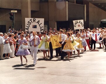 Vision Australia
Photograph - Image, Square Dancers in Street Parade in Winnepeg, Canada, 1984
The Guiding Light Square Dancer club taking part in a street parade in Winnipeg, Canada, as part of the Canadian National Square and Round Dance convention. Marching in the group: Alan Egerton is front left partnered by Ruth and Wanda Egerton is front right partnered by Shane. Steven, Jeff, Margaret Snyder and Peggy Sitlington.1 color photograph of people in square dancing outfits walking in a street paraderecreation, margaret fox, wanda egerton, alan egerton, guiding light square dance club -
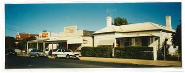
 Stawell Historical Society Inc
Photograph, Houston Street looking towards Grampians -- Coloured
Large Colour photo of Houston Street looking towards Grampians. Brick fence on left.Coloured Photograph of a street looking toward the grapians whih are covered in clouds. Brick fence ofn left and a white car in the mid distance.stawell houses -
 Eltham District Historical Society Inc
Photograph, Brougham Street West, Eltham
Colour photograph of Brougham Street between Susan Street and Bolton Streetbrougham street, eltham -
 Tatura Irrigation & Wartime Camps Museum
Photograph, Mactier Gardens and Victoria Hotel, Hogan Street, Tatura
Shows picture of Mactier Gardens and Victoria Hotel, Hogan Street, Tatura,.Colour photograph showing Mactier Gardens (on left) and Victoria Hotel (on right) Hogan Street, Tatura. Photograph stuck onto piece of white cardboard. hogan street tatura, mactier gardens tatura, victoria hotel tatura -
 Ballarat Heritage Services
Photograph - Image, Anticlinal Fold, Lyttleton Street, Castlemaine, c1880, c1880
In 1927 a plaque was installed at this anticlinal fold. Since no plaque is evident in the photo the date would be pre1927. The plaque states "This fine exhibit was disclosed when Lyttleton Street East was constructed in 1874. Saddle reefs occur in similar folds of the sandstones and slates on lower geological horizons." An anticline at Castlemaine, Victoria. This natural feature was uncovered during Lyttleton Street roadworks in 1880. anticlinal fold, geology, castlemaine -
 Kew Historical Society Inc
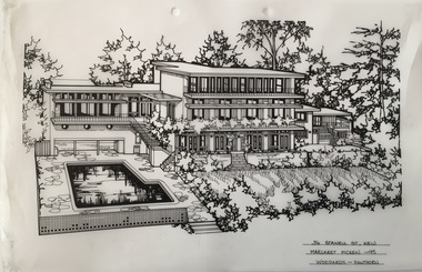
Drawing - Property Illustration, Margaret Picken, 36 Stawell Street, Kew, 1995
After training as a Cartographic Draftsman within the mining industry, I worked as a property illustrator for real estate firms in the eastern suburbs of Melbourne for 22 years from 1983. I initially photographed houses with a Polaroid camera and made a 'thumbnail' sketch while there. The photos were used to scale off a sketch in pencil and then that sketch was overlaid with drafting film and the 'pen and ink' completed. The pens I used were the Rotring ‘Rapidigraph’ drafting pens. The ink was also made by Rotring (German).The film was ‘Rapidraw’, polyester drafting film, double matte. It takes a very fine line and doesn’t bleed. As well as house sketches, there were often floor plans and site plans ordered. Aerial sketches were ordered when the property needed an overall view. (Margaret Picken, 2020)36 Stawell Street in Kew was built to a design by Anatol Kagan & Associates in 1952. The drawing, dating from 1995, is one of a series of property illustrations created by Margaret Picken for real estate agents in Melbourne between 1983 and 2005. Each work is signed and dated by the artist.Gift of Margaret Picken, 2020Pen and ink drawing on drafting film of 36 Stawell Street, Kew by Margaret Picken.36 STAWELL ST., KEW / MARGARET PICKEN ~95 / WOODARDS ~ HAWTHORNartist -- margaret picken 1950-, architectural drawings -- houses -- kew (vic.), 36 stawell street - kew (vic), anatol kagan & associates - buildings -- kew (vic.) -
 Greensborough Historical Society
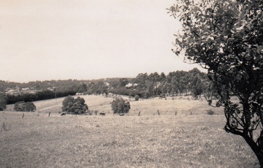
Photograph - Digital Image, Cherel Sartori, Looking east from Henry Street to the river 1956, 01/01/1956
Looking from Henry Street east to the Plenty River, 1956. The house was built 1917, at 112 Henry Street Greensborough by William Mitchell on the 60 acre dairy farm owned by Ethel and Walter Kell. This collection of photographs was copied by Cherel Sartori (who owned the house from 1990-2000), following a visit by Claude Amiet who lived in the house as a child in the early 20th century.An indication of the rural aspect of this area in the mid-20th century.Digital copy of black and white photographkell's cottage, claude amiet, cherel sartori -
 Charlton Golden Grains Museum Inc
Photograph, Charlton Shire, c.1987
Corner High Street and Learmonth Street. 2 shops demolished by Greg Fatheres. Shop on left Paterson's fruit and veg c.1935. Butchers shop. rebuilt by Graeme Turner, Marini's take away cafe. Dalgety's, Building at back home of Sheisa Volch facing Learnmouth Street.Corner High Street and Learmonth Street, 2 Shops demolished by Greg Fathersdemolition, charlton, high street, shops, butcher, business, dalgety's, paterson -
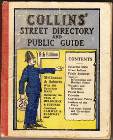 Cheese World Museum
Book, Queen City Printers Pty Ltd, Collins Street Directoryand Publice Guide: 8th Edition
The Percy Uebergang family lived at Tooram Park, Allansford from 1912 until 1992. This booklet was part of the collection of items given into the care of the Cheese World Museum. Uebergang catalogue No. -not listed White hard cover pocket-sized street directory book with red cloth spine. The front cover has a blue and yellow background with title, contents, edition listed and a policeman in a blue uniform. The back cover has information in black print. Melbourne and suburbs maps throughout. 439 pages.COLLINS' STREET DIRECTORY/AND/PUBLIC GUIDE/8th Edition/2/6 each/CONTENTS/ Suburban Maps/Street Indices/Public Buildings/Tourist Information and Holiday Notes/Weights and Measures/Postal Rates/Calendar/Conversion Tables/Justices of the Peace/And other useful and up-to-date matterallansford, uebergang, street directory, public guide, collins, melbourne, maps, tourist information, queen city printers pty ltd, almanacs, local history