Showing 3911 items
matching creek street
-
 Bendigo Art Gallery
Painting, Peter TYNDALL, A Person Looks At A Work Of Art/someone looks at something LOGOS/HA HA/ The Triumph of Charing Cross over Bednego Creek/ (after The Triumph of Christianity over Paganism,/ by Tommaso Siciliano), 1997
Not signed Not datedcontemporary art, conceptual art, australian artist, painting, looking, bendigo, central victoria, charing cross -
 Bendigo Art Gallery
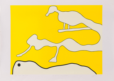
Print - Work on paper, Brent HARRIS, On Becoming (Yellow) (No.1), 1998
l.l; 21/35 MOGGS CREEK EDITION, c; 'On Becoming' (Yellow) (No.1), l.r; Brent Harris 98print, printmaker, printmaking, australian artist, abstract, screenprint, yellow -
 Clunes Museum
Photograph - PHOTOGRAPHS
Two laminated black and white photographs of groups of men in front of what appears to be at mine site..1 on Reverse; McClean great grandfather was Bates .2 Location "Mile Creek" sawmillbates, afghan -
Clunes Museum
Photograph - POSTCARDS
Photograph postcards, black and white images of Clunes and surrounds; .1 St. Paul's C of E Clunes .2 Methodist Church, Clunes .3 Tullarook Creek, Clunes .4 Monument at Clunes .5 Soldier's Memorialclunes history, methodist church -
Clunes Museum
Plan - PLANS, Harry E Sando, Borough of Clunes Contract 96.6 of 1893/4, c1894
Harry E Sando C.E. (Borough Enginee) as at 10th March 1894, this plan also signed by the contactor and witness, both signatures are illegibleColoured drawings on tracing/architects papers, pinned with dress makers pins to stiff paper. Scale 2 feet to 1 inchHeadings on plans; "Ground Plan No.1, Ground Plan No.2, Sections of weirscreswick creek, flood mitigation, weir system -
Clunes Museum
Photograph, 2010
.1 Bridge was damaged and closed for repairs for about 6 months .2 Government bridge is higher and was not damaged.1 colour photograph of flooded creek at the newer bridge, water is hitting the bridge .2 colour photo of Government bridge during the floods, water is below the top of the bridge.1 T. Goldworthy 4th Sept. 2010 about midday .2 T. Goldworthy 4th Sept. 2010 about middaybridges, floods, photograph, goverment bridge -
 Horsham Regional Art Gallery
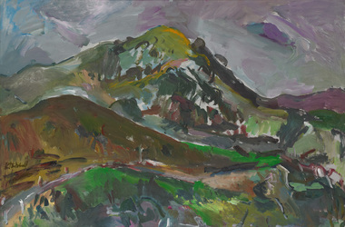
Painting, Kathleen MITCHELL, Strath Creek, n.d
Gift of Mack Jost, 1992oil on board -
 St Kilda Historical Society
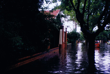
Photograph, St Kilda floods, 23 January 1991 - images collection, 23/01/1991
Heavy rains caused flooding in the Port Phillip area on 23 January 1991, including in St Kilda. The level of Elster Creek, Elsternwick, rose to 2.54m (from normal level of 0.1m) and there was historically high flooding along Elwood CanalColour photographFlood 23/1/91 9.30amst kilda, flood 1991, 23 january 1991, 23/01/91 -
Clunes Museum
Document - GLENGOWER/GLENDONALD POST OFFICE
... Clunes Museum 36 Fraser Street Clunes goldfields MIDDLE ....1 PHOTOCOPY OF HISTORY OF GLENDONALD POST OFFICE GLENDONALD POST OFFICE WAS OPENED ON 15 JANUARY 1868, AND WAS MADE A RECEIVING OFFICE ON 19 AUGUST 1894. IT WAS CLOSED ON 1 JULY 1917. IT USED BARRED NUMERAL CANCEL 639. GLENDONALD WAS A SMALL RURAL SETTLEMENT LOCATED ON THE INTERSECTION OF TH CRESWICK-CLUNES ROAD AND MINER'S REST-CASTLEMAINE ROAD BETWEEN CLUNES AND CRESWICK. IT WAS SITED AT THE FOOT OF CATTLE STATION HILL. BETWEEN 1874 AND 1885 THE POST OFFICE WAS CONDUCTED BY THE CATTLE STATION STATE SCHOOL HEADMASTER POST OFFICERS AT GLENDONALD WERE: WILLIAM B. LANGDON 1868 E S LANGDON 1868 - 1870 ELISABETH GOOD 1870-1874 ALEXANDER GILLIAN 1874-1885 ARTHUR W BEAN 1885 CHARLOTTE VALINS 1885 THOMAS DUNSTON 1885-1894 ELIZABETH PEARCY 1894-1901 EDWARD PEARCY 1901-1913 NOT KNOWN 1913-1917 .2PHOTOCOPY OF HISTORY OF GLENGOWER/MIDDLE CREEK POST OFFICE GLENGOWER POST OFFICE OPENED ON 13 JANUARY 1868 AS MIDDLE CREEK. ITS NAME WAS CHANGED ON 1 JUNE 1881, WHEN IT BECAME A RECEIVING OFFICE. A MIDDLE CREEK POST OFFICE WAS OPENED NEAR ARARAT IN 1881 AND THE POSTMASTER GENERAL HAD A POLICY OF NOT HAVING POST OFFICES HAVING THE SAME NAME. GLENGOWER WAS UPGRADED TO POST OFFICE ON 1 JULY 1927, IT CLOSED ON 30 JUNE 1952 BARRED NUMERAL CANCEL 632 WAS USED AT GLENGOWER POST OFFICERS AT GLENGOWER WERE: S IRWIN 1868-1869 DONALD FRASER 1869-1871 JOHN KEMP 1871-1873 JOHN NEWTON 1873-1876 W POTTER 1876-1887 ANNIE MCIVOR 1887-1892 JESSIE MCIVOR 1892-?? UNKNOWSN ????-1927 DJ FRASER 1927-1939 JAMES CAMPBELL 1939-1952middle creek post office, glengower post office, glendonald post office -
Clunes Museum
Work on paper - FAMILY HISTORY BENJAMIN WHITE
BENJAMIN AND SARAH WHITE ARE RECORDED IN "SOUTH AUSTRALIANS 1836-1885" BOOK TWO.DESMA FAY NICHOLSON OF 160 FRANCIS ST RICHMOND NSW PROVIDED THE INFORMATION FOR THE BOOK. DESMA IS A DESCENDENT OF JOHN WHITE, FIFTH AND YOUNGEST SON OF BENJAMIN WHITE BENJAMIN WHITE PARENTS BENJAMIN AND JANE (NEE LOWDEN- SHOULD BE SOWDEN) BORN 1819 CAMBORNE, CORNWALL DIED JAN 1874 VICTORIA, BURIED IN CRESWICK ARRIVED SA 29/10/1847 FROM ENGLAND ON DUCHESS OF NORTHUMBERLAND DEPARTED SA C. 1852 FOR VICTORIA OVERLAND OCCUPATION MINER AND SECTON RESIDENCE: KAPUNDA ALLENS CREEK SA RELIGION: WESLEYAN HE MARRIED SARAH (SALLY) BAILEY ON 02/08/1845 IN CAMBORNE ENGLAND, SHE DIED 12/08/1891 IN CRESWICK CHILDREN: SARAH ANNE WILLIAMS 07/09/1845 TO 18/06/1890 ELIZABETH ORRINGE 22/02/1847 TO 16/10/1920 BENJAMIN 22/04/1849 TO 19/02/1889 HARRIET 29/08/1850 TO 15/05/1851 WILLIAM BAILEY 22/10/1851 TO 14/03/1916 JOSEPH 20/11/1853 TO 17/05/1910 THOMAS HENRY 15/05/1855 TO 15/08/1917 JOHN 14/04/1857 TO 27/02/1935 HARRIET 17/01/1860 TO 14/06/1863 DECIMA JANE CHEGWYN 04/01/1862 TO 28/02/1940 EMILY WILSON 07/03/1864 TO 19/08/1937 BENJAMIN WHITE MARRIED SARAH BAILEY IN CORNWALL IN SEPTEMBER 1845, JUST ONE MONTH BEFORE THE BIRTH OF THEIR FIRST CHILD SARAH ANN. SECOND CHILD ELIZABETH WAS BORN IN MARCH 1847 JUST SIX MONTHS BEFORE THE FAMILY SAILED FOR SOUTH AUSTRALIA ON THE NORTHUMBERLAND. THE MANNING INDEX OF SOUTH AUSTRALIAN HISTORY REC9ORDS THAT BENJAMIN WHITE WAS RESPONSIBLE FOR "CREATING" THE ALLEN CREEK VILLAGE 5 KM NORTHWEST OF KAPUNDA C. 1849. CERTAINLY AT ONE STAGE BENJAMIN HAD A CONSIDERABLE LAND HOLDING ADJACENT TO ALLEN'S CREEK VAL LAWRENCE SUGGESTS THAT THE WHITE FAMILY TRAVELLED BY SEA FROM SA TO VICTORIA, NOT OVERLAND AS SUGESTED BY DESMA NICHOLSON IN "SOUTH AUSTRALIANS 1836-1885 ACCORDING TO CRSWICK HOSPITAL RECORDS BENJAMIN WHITE WAS ADMITTED JUNE 27 1873 (AGE 49 MARRIED, GRAVEDIGGER AT CRESWICK, BORN IN ENGLAND, WESLEYAN) AND LEFT HOSPITAL JULY 14 1873. A CHRONICALLY ILL CONDITION WAS RELIEVED. BENJAMIN WHITE DIED DECEMBER 22, 1873. A SPECIAL CHURCH SERMON WAS CARRIED OUT ON SUNDAY JANUARY 43 1874benjamin white, sarah white, sarah bailey -
Clunes Museum
Photograph
COPY OF PHOTOGRAPH OF FLOOD ON CRESWICK CREEK AT SUSPENSION BRIDGE BEHIND KEEBLE'S 8/9/1909 TALBOT RD CLUNES. IT WAS THIS BRIDGE THAT MR. WATSON WAS SO NEARLY CARRIED DOWN WITH THE RUSHING WATERS. HE WAS STANDING ON PART OF IT, WHEN IT BROKE AWAY AND HE MANAGED TO CLING TO TO THE REMAINSsuspension bridge flood, flood creswick creek, 1909 flood -
Clunes Museum
Photograph
COPY OF PHOTOGRAPH OF FLOOD ON CRESWICK CREEK AT GOVERNMENT BRIDGE12/9/1909 FROM CLUNES TALBOT RD. MOTHER WRITING TO AMY. CLUNES JUBILEE BRIDGE DURING THE SEVERE FLOOD, WHEN AT ITS HIGHEST MARK. IT REMINDED ME OF SEA WAVES. THE WATER WAS AT OUR FEET AS WE STOOD WATCHING IT IN MRS BARKELL'S COW YARD. MRS BARKELL AND MARY WHITE (THE WRITER) TOOK IT IN TURNS TO COOK DINNER AND WATCH THE FLOODflood 1909, mrs a white, flood creswick creek -
Clunes Museum
Document - DOCUMENTS
.1 DILAPIDATION ASSESSMENT AND RESTORATION PROPOSAL FOR THE QUEENS PARK FOUNTAIN AT CLUNES, AUGUST 1993 .2 CRESWICK CREEK WALK PROJECT 2005 WITH CORRESPONDENCE FROM MICHAEL CHESHIRE .3 CLUNES WALKING TRACK WITH DETAILS OF WORK TO BE UNDERTAKEN 2005 .4 "TAKE BACK THE CREEK" COMMUNITY MEETING - AGENDA FOR MEETING 8/8/2005 .5 ACCOUNT FOR CRUSHED ROCK AND GRANITE SAND 17/05/2005 .6 MAP OF HEPBURN SHIRE SHOWING LANDCARE GROUPS .7 CTDA LETTER DATED 14/06/2005 REGARDING PLANNING WORKSHOP .8 QUEENS PARK FENCE PROJECT REPORT 2003 .9 MINUTES OF GENERAL MEETING OF CLUNES LANDCARE GROUP FROM 23/07/2002 TO 12/05/2005 .clunes landcare group, queens park fountain, creswick creek walk -
Clunes Museum
Pamphlet - BROCHURES
... , CLUNES - SHOWING WALK FRO FRASER STREET AND AROUND CREEK...Clunes Museum 36 Fraser Street Clunes goldfields TOURIST ...BROCHURES IN ENVELOPE: COLLECTION OF ADVERTISING OF CLUNES FOR DISTRIBUTION AG INFORMATION CENTRE. MAP OF CLUNES, A TASTY LITTLE TOURING MAP CENTRED ON DAYLESFORD AND MT MACEDON, WALKS AND RIDES , CLUNES - SHOWING WALK FRO FRASER STREET AND AROUND CREEK. MENTION OF MT. BECKWORTH, POSTCARD WITH TOWN NAMES, CLUNES BROCHURE DINING AND TAKE AWAY FOR HEPBURN, DAYLSFORD, MACEDON RANGES. VISITOR GUIDEtourist informaion, brochures -
Clunes Museum
Photograph
TWO PHOTOGRAPHS OF BUILDING A BANK BETWEEN THE CREEK AND THE FOOTBALL GROUND IN 2012football ground, creek -
Clunes Museum
Photograph
.1 17 PHOTOGRAPHS OF CENTENARY/BACK TO CLUNES 1939 .2 PHOTOGRAPH OF SCHOOL, BAILEY STREET .3 KODAK ENVELOPE FOR PHOTOGRAPHS .4 4 PHOTOGRAPHS OF CREEK IN FLOOD.3 WRITING ON COVER RED ON BLACK: HAPPY SNAPSback to clunes, centenary 1939 -
Clunes Museum
Artwork, other - PAINTING
.1 PENCIL SKETCH OF A CREEK, A PUBLIC BATH HOUSEON THE OTHER SIDE OF THE CREEK AND A RAT ON THE BUILDING. A CAT ON THIS SIDE GREY ON BEIGE, GOLD CRACKED FRAME .2 PHOTOCOPY OF THE DRAWING .3 ORIGINAL BACKING OF THE DRAWING WITH PIECES OF WRITTEN NOTES AND NEWSPAPER CLIPPINGS BUT ILLEGIBLE, BROWN PAPER.1 ON SKETCH: CAT:AH MY SOTT!! DERE IS ZE RAT ON ZE HOUSE OF ZE ISLAND, I WILLHAVE A POKE AT HIM BUT - OH - IF I MISSES HIM HE MAY FLY AT ME, SOTTTAM RAT HApencil sketch, cartoon sketch -
Clunes Museum
Textile - MANCHESTER ANTIMACASSAR
2 HAND MADE CLOTH RIBBON, CROCHET IN CENTRE AND ALCE EDGING. MADE BY LOUISE MCCUBBIN, COGHILLS CREEK C 1880antimacassar, manchester, louise mccubbin -
 El Dorado Museum Association Inc.
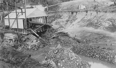
Photograph (item) - Digital Image
Clear Creek Tin Mine, c.1931mines, mining, tin, tin mining, men, sluicing, clear creek, el dorado, eldorado -
 El Dorado Museum Association Inc.
Photograph (item) - Digital Image
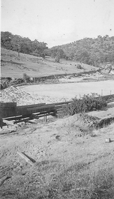
Clear Creek Dammines, mining, tin, tin mining, sluicing, clear creek, el dorado, eldorado -
 El Dorado Museum Association Inc.
Photograph (item) - Digital Image
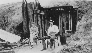
Clear Creek Tin Mine Dugoutmines, mining, tin, tin mining, sluicing, men, boys, clear creek, el dorado, eldorado -
 El Dorado Museum Association Inc.
Photograph (item) - Digital Image
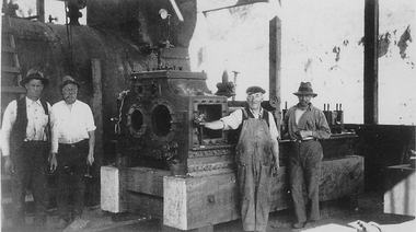
Clear Creek Tin Mine, c.1931mines, mining, tin, tin mining, steam, engine, men, miners, machinery, clear creek, el dorado, eldorado -
 El Dorado Museum Association Inc.
Photograph (item) - Digital Image
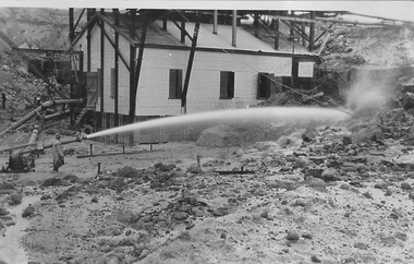
Processing shed and sluicing nozzle, probably Clear Creek Tin Minemining, tin, tin mining, clear creek, sluicing, el dorado, eldorado -
 El Dorado Museum Association Inc.
Photograph (item) - Digital Image
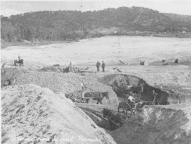
Altering course of Reedy Creek, El Dorado. Cocks Pioneer Electric Gold & Tin Mine Company was formed in 1899. The company's first power station, located at the eastern end of the valley began operating with its 340 Kilowatt steam-powered generator. By 1909, from 2,500,000 cubic yards worked, reported recovery was 17,284 ounces of gold and 224 tons of tin ore. By 1909, Cocks Pioneer’s power plant had become inadequate and uneconomical. The barge was floated downstream about a mile, but lost time caused the operations to cease. Following testing, a new mine was established by diverting Reid's Creek at a cost of £25 000. Settling dams were built, one of which held 1,935,900 cubic feet. Sold earth banks, built against a wall of stringy bark saplings constructed and laced with vertical props, were built. In 1914, the company was reformed as Cock’s Pioneer Gold and Tin Mines NL, another power station was constructed at the western end of the township, near the junction of Clear and Reid's Creeks. From 6,800,000 cubic yards of material processed, the returns were 64,397 ounces of gold and 855 ton of tin. Cocks Pioneer mine then moved the barge downs stream and continued sluicing. In 1929 Cocks Pioneer Electric Gold and Tin Mining Company ceased operations due to a drop in values. Cock’s Pioneer Gold and Tin Mines NL carried on large-scale hydraulic sluicing operations until 1941. Handwritten across the front: 'Altering course of creek. Eldorado'mining, gold, tin, sluicing, reedy creek, cocks pioneer, el dorado, eldorado, men, horses -
 El Dorado Museum Association Inc.
Photograph (item) - Digital Image
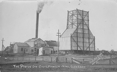
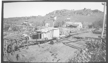
Cocks Pioneer Mine El Dorado, Power Station No. 2 was established in 1914 and located near junction of Reid's and Clear Creeks, Byawatha. Cocks Pioneer Electric Gold & Tin Mine Company was formed in 1899. The company's first power station, located at the eastern end of the valley began operating with its 340 Kilowatt steam-powered generator. By 1909, from 2,500,000 cubic yards worked, reported recovery was 17,284 ounces of gold and 224 tons of tin ore. By 1909, Cocks Pioneer’s power plant had become inadequate and uneconomical. The barge was floated downstream about a mile, but lost time caused the operations to cease. Following testing, a new mine was established by diverting Reid's Creek at a cost of £25,000. Settling dams were built, one of which held 1,935,900 cubic feet. Sold earth banks, built against a wall of stringy bark saplings constructed and laced with vertical props, were built. In 1914, the company was reformed as Cock’s Pioneer Gold and Tin Mines NL, another power station was constructed at the western end of the township, near the junction of Clear and Reid's Creeks. From 6,800,000 cubic yards of material processed, the returns were 64,397 ounces of gold and 855 ton of tin. Cocks Pioneer mine then moved the barge downs stream and continued sluicing. In 1929 Cocks Pioneer Electric Gold and Tin Mining Company ceased operations due to a drop in values. Cock’s Pioneer Gold and Tin Mines NL carried on large-scale hydraulic sluicing operations until 1941. Handwritten on front: 'THE POWER STN COCKS, PIONEER MINE, ELDORADO' / 'THELMA STUDIO / [underlined] WANGARATTA'mining, gold, tin, cocks pioneer, power, sluicing, el dorado, eldorado, byawatha, thelma studios, wangaratta, gold mining, tin mining, reid's creek, clear creek -
 El Dorado Museum Association Inc.
Photograph (item) - Digital Image
Cocks Pioneer Creek Diversion. Cocks Pioneer Electric Gold & Tin Mine Company was formed in 1899. The company's first power station, located at the eastern end of the valley began operating with its 340 Kilowatt steam-powered generator. By 1909, from 2,500,000 cubic yards worked, reported recovery was 17,284 ounces of gold and 224 tons of tin ore. By 1909, Cocks Pioneer’s power plant had become inadequate and uneconomical. The barge was floated downstream about a mile, but lost time caused the operations to cease. Following testing, a new mine was established by diverting Reid's Creek at a cost of £25,000. Settling dams were built, one of which held 1,935,900 cubic feet. Sold earth banks, built against a wall of stringy bark saplings constructed and laced with vertical props, were built. In 1914, the company was reformed as Cock’s Pioneer Gold and Tin Mines NL, another power station was constructed at the western end of the township, near the junction of Clear and Reid's Creeks. From 6,800,000 cubic yards of material processed, the returns were 64,397 ounces of gold and 855 ton of tin. Cocks Pioneer mine then moved the barge downs stream and continued sluicing. In 1929 Cocks Pioneer Electric Gold and Tin Mining Company ceased operations due to a drop in values. Cock’s Pioneer Gold and Tin Mines NL carried on large-scale hydraulic sluicing operations until 1941. mining, gold, tin, cocks pioneer, creek, gold mining, tin mining, el dorado, eldorado -
 El Dorado Museum Association Inc.
Photograph (item) - Digital Image
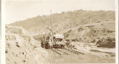
Cocks Pioneer Barge. Cocks Pioneer Electric Gold & Tin Mine Company was formed in 1899. The company's first power station, located at the eastern end of the valley began operating with its 340 Kilowatt steam-powered generator. By 1909, from 2,500,000 cubic yards worked, reported recovery was 17,284 ounces of gold and 224 tons of tin ore. By 1909, Cocks Pioneer’s power plant had become inadequate and uneconomical. The barge was floated downstream about a mile, but lost time caused the operations to cease. Following testing, a new mine was established by diverting Reid's Creek at a cost of £25,000. Settling dams were built, one of which held 1,935,900 cubic feet. Sold earth banks, built against a wall of stringy bark saplings constructed and laced with vertical props, were built. In 1914, the company was reformed as Cock’s Pioneer Gold and Tin Mines NL, another power station was constructed at the western end of the township, near the junction of Clear and Reid's Creeks. From 6,800,000 cubic yards of material processed, the returns were 64,397 ounces of gold and 855 ton of tin. Cocks Pioneer mine then moved the barge downs stream and continued sluicing. In 1929 Cocks Pioneer Electric Gold and Tin Mining Company ceased operations due to a drop in values. Cock’s Pioneer Gold and Tin Mines NL carried on large-scale hydraulic sluicing operations until 1941. mining, gold, tin, barge, sluicing, gold mining, tin mining, cocks pioneer, el dorado, eldorado -
 El Dorado Museum Association Inc.
Photograph (item) - Digital Image
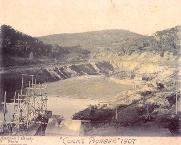
Cocks Pioneer, 1907. Cocks Pioneer Electric Gold & Tin Mine Company was formed in 1899. The company's first power station, located at the eastern end of the valley began operating with its 340 Kilowatt steam-powered generator. By 1909, from 2,500,000 cubic yards worked, reported recovery was 17,284 ounces of gold and 224 tons of tin ore. By 1909, Cocks Pioneer’s power plant had become inadequate and uneconomical. The barge was floated downstream about a mile, but lost time caused the operations to cease. Following testing, a new mine was established by diverting Reid's Creek at a cost of £25,000. Settling dams were built, one of which held 1,935,900 cubic feet. Sold earth banks, built against a wall of stringy bark saplings constructed and laced with vertical props, were built. In 1914, the company was reformed as Cock’s Pioneer Gold and Tin Mines NL, another power station was constructed at the western end of the township, near the junction of Clear and Reid's Creeks. From 6,800,000 cubic yards of material processed, the returns were 64,397 ounces of gold and 855 ton of tin. Cocks Pioneer mine then moved the barge downs stream and continued sluicing. In 1929 Cocks Pioneer Electric Gold and Tin Mining Company ceased operations due to a drop in values. Cock’s Pioneer Gold and Tin Mines NL carried on large-scale hydraulic sluicing operations until 1941. Handwritten across front: 'HAROLD S. TEMBY / Photo'; '"COCKS PIONEER" 1907'.mining, gold, tin, open cut, barge, gold mining, tin mining, cocks pioneer, el dorado, eldorado -
 El Dorado Museum Association Inc.
Photograph (item) - Digital Image
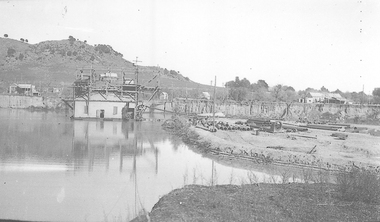
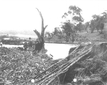
Cocks Pioneer after Flood. Cocks Pioneer Electric Gold & Tin Mine Company was formed in 1899. The company's first power station, located at the eastern end of the valley began operating with its 340 Kilowatt steam-powered generator. By 1909, from 2,500,000 cubic yards worked, reported recovery was 17,284 ounces of gold and 224 tons of tin ore. By 1909, Cocks Pioneer’s power plant had become inadequate and uneconomical. The barge was floated downstream about a mile, but lost time caused the operations to cease. Following testing, a new mine was established by diverting Reid's Creek at a cost of £25,000. Settling dams were built, one of which held 1,935,900 cubic feet. Sold earth banks, built against a wall of stringy bark saplings constructed and laced with vertical props, were built. In 1914, the company was reformed as Cock’s Pioneer Gold and Tin Mines NL, another power station was constructed at the western end of the township, near the junction of Clear and Reid's Creeks. From 6,800,000 cubic yards of material processed, the returns were 64,397 ounces of gold and 855 ton of tin. Cocks Pioneer mine then moved the barge downs stream and continued sluicing. In 1929 Cocks Pioneer Electric Gold and Tin Mining Company ceased operations due to a drop in values. Cock’s Pioneer Gold and Tin Mines NL carried on large-scale hydraulic sluicing operations until 1941. mining, gold, tin, barge, floods, gold mining, tin mining, cocks pioneer, el dorado, eldorado, men -
 El Dorado Museum Association Inc.
Photograph (item) - Digital Image
Cocks Pioneer Electric Gold & Tin Mine Company was formed in 1899. The company's first power station, located at the eastern end of the valley began operating with its 340 Kilowatt steam-powered generator. By 1909, from 2,500,000 cubic yards worked, reported recovery was 17,284 ounces of gold and 224 tons of tin ore. By 1909, Cocks Pioneer’s power plant had become inadequate and uneconomical. The barge was floated downstream about a mile, but lost time caused the operations to cease. Following testing, a new mine was established by diverting Reid's Creek at a cost of £25,000. Settling dams were built, one of which held 1,935,900 cubic feet. Sold earth banks, built against a wall of stringy bark saplings constructed and laced with vertical props, were built. In 1914, the company was reformed as Cock’s Pioneer Gold and Tin Mines NL, another power station was constructed at the western end of the township, near the junction of Clear and Reid's Creeks. From 6,800,000 cubic yards of material processed, the returns were 64,397 ounces of gold and 855 ton of tin. Cocks Pioneer mine then moved the barge downs stream and continued sluicing. In 1929 Cocks Pioneer Electric Gold and Tin Mining Company ceased operations due to a drop in values. Cock’s Pioneer Gold and Tin Mines NL carried on large-scale hydraulic sluicing operations until 1941. mining, gold, tin, barge, sluicing, gold mining, tin mining, cocks pioneer, el dorado, eldorado