Showing 2185 items
matching nillumbik
-
 Eltham District Historical Society Inc
Photograph - Colour Print, Belle Vue, Livingstone Road, Eltham, c.2015
Belle Vue property in Livingstone Road, Eltham was once owned by Society member Jo McCormick. Jo was a valued member of our committee and dear friend of many of our members until her death in 2009. Belle Vue is the farmhouse of a property that is now a significant part of suburban Eltham, just a short distance north of the town centre. Originally purchased by pioneer Eltham farmer Henry Stooke, the present-day old farmhouse sits within an extensive suburban residential area. The history of the property is largely based on a heritage assessment prepared by consultant Lorraine Huddle for Nillumbik Shire Council. Additional information from our Society records reveals Belle Vue farm comprised about 56 ha (140 acres) extending northerly from the northern boundary of Holloway’s 1851 Little Eltham subdivision. On the present day map the southern boundary was just north of Elsa Court and Grove Street. The western boundary was the Diamond Creek and extended northerly to Main Road where it turns easterly towards Research. It was traversed by the main road to Kangaroo Ground and beyond and from 1912 by the railway to Hurstbridge. From 1895 the farm was owned by William Williams and his wife Mary Ann. In 1914 -15 they built a new house now known as Belle Vue. They sold the land in 1920 and residential subdivision began soon after that. Belle Vue remains today on a substantially subdivided and very much reduced size residential lot in Livingstone Road. The house and many old trees on the site were subject to a heritage overlay under the Nillumbik Planning Scheme. Despite that overlay, the development and subdivision of the original land resulted in most of the heritage listed trees being removed. belle vue, eltham, livingstone road -
 Eltham District Historical Society Inc
Photograph, Fay Bridge, Footbridge, Fort Knox Self Storage, 197 Sherbourne Road, Eltham, n.d
The footbridge which extended from the facility to the landscaped garden and water features is now gone. The footbridge and garden were previously part of a former hat factory in Sherbourne Road Eltham which has in the past been used for various purposes and presently a self storage business. The Karingal Yallock Creek passes through the front of the land and the creek environs are the subject of significant and unusual landscaping works, including some cascading water channels. Some of the landscaping was damaged by the Christmas Day floods of 2011, but the main elements remain intact. The landscaped area (as distinct from the factory itself) is the subject of a Heritage Overlay under the Nillumbik Planning Scheme. The basis of this overlay is a Heritage Report by Graeme Butler and Associates in 2006. As well as an assessment of the landscaped area, it includes one background information on the history of the site (although a complete history would require more research). The site was part of Crown Portion 3 of the Parish of Nillumbik that remained as the Montmorency Farm until early in the twentieth century. The 1911 subdivision of this farm created Lot 7 of some seven acres, which is the site of this factory. The Heritage Report lists the various owners of the site. From the rate records and aerial photos it is concluded that the site was used as an orchard and farmland until the 1940s. William F Crellin, orchardist, owned the site from 1912 to 1923. Then Edmund Williams owned it until 1951. In 1955 the site was owned by Rupert V. Kirsch and this is the name anecdotally associated with the hat factory, where the well-known brand of Fayrefield Hats were manufactured. There is some belief that this was built about the time of the Second World War and that hats for the armed forces were made there.fay bridge collection, eltham, fayrefield hat factory, foot bridge, sherbourne road, footbridge, fort knox eltham -
 Eltham District Historical Society Inc
Photograph, Fay Bridge, Eastern boundary of former Warrandyte Aboriginal Reserve, North Warrandyte, 7 November 2016
Two bronze commemorative plaques on rocks, unveiled by Wurundjeri Tribe Council Elders, mark two eastern boundaries of the former Warrandyte Aboriginal Reserve on the north and south sides of the Yarra. This project was initiated by Nillumbik Reconciliation Group in close association with Reconciliation Manningham and the Wurundjeri Tribe Council, as a means of commemorating the last great corroboree of the Kulin Nation which was held at Pound Bend in March 1852. This plaque is on the Nillumbuk side of the Yarra, accessed via The Boulevard, North Warrandyte. The plaque is set on a rock approximately 50 metres before the turning circle at the end of The Boulevard. Plaque : Warrandyte Aboriginal Reserve This commemorative rock marks an eastern boundary of the former Warrandyte Aboriginal Reserve established in 1852. Centred on Pound Bend, it covered 1,908 acres on both sides of the Yarra River (Birrarung). That same year saw the last great gathering of the Kulin nation here in Wurundjeri country which was celebrated over two weeks with traditional performance and games. For a few years longer the reserve intermittently served as a ration station.With gold having been discovered at Warrandyte, the Wurundjeri were moved on again but ultimately secured a permanent home at Coranderrk, Healesville. A second commemorative plaque and rock is located on the opposite bank of the Yarra and its confluence with Stony Creek. Melway ref : 23 C 9 Unveiled by Wurundjeri Elder, Uncle Bill Nicholson on 23rd March 2013 Funded by the Robert Bridgford Indigenous Trust (Nillumbik Community Fund) with assistance from Manningham City Council Small Grants Program Ref: Monument Autralia https://monumentaustralia.org.au/themes/culture/indigenous/display/99680-warrandyte-aboriginal-reserve-fay bridge collection, 2016-11-07, aboriginal reserve, north warrandyte, plaques, warrandyte aboriginal reserve -
 Eltham District Historical Society Inc
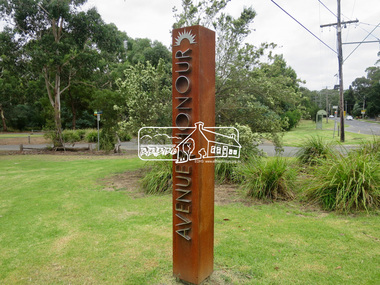
Photograph, Jim Connor, Avenue of Honour, Main Road, Eltham, 14 Jan 2017
Walking or driving up Main Road, you enter Eltham’s Avenue of Honour, with its rows of plane trees, each commemorating the death of a soldier sent to fight in World War 1. 115 trees were first planted on 21st September 1917 beginning at “the flat” to the intersection of Pitt Street. Tree guards and copper name plates were later added. In the ‘20s and ‘30s too many branches were broken off by carriers whipping their horses up the steep slope. In the 1950s many of the original trees were removed for road widening and new plane trees were planted in their place. In June 2015 during the Anzac Centenary, Nillumbik Shire Council dedicated the new Avenue of Honour in the Eltham Gateway. New markers commemorate local soldiers. Tomorrow's history documented todayeltham, jim connor collection, main road, avenue of honour, eltham gateway, commemoration, marker -
 Eltham District Historical Society Inc
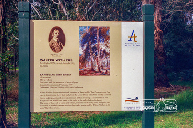
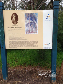
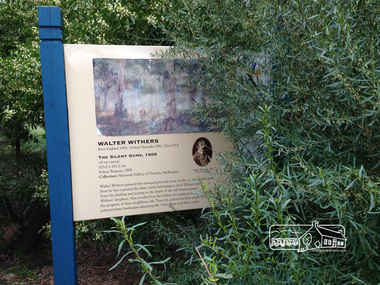
Photograph, Heidelberg Artists Trail sign, "Landscape with Sheep" Walter Withers, Wingrove Park, Eltham, c.May 2001
The Heidelberg School Artists Trail was established in about 1999 with about 52 signs across four local governemnt areas including Nillumbik and Banyule. This one acknowledges "Landscape with Sheep" by Walter Withers. The text on the board states: Walter Withers depicts in this work a number of sheep on Mr. Tom Orr’s property. Our view is from the rise above this park, from the Lower Plenty side of the nearby Diamond Creek, looking northwards towards the main Eltham township. The area that is now Wingrove Park, would have been to the right, in the valley below the sheep. The mood of this work is warm and vibrant, with the use of strong blues and pinks, and this stands in marked contrast to the softer, cooler greens used by Walter Withers in his work ‘The Silent Gums’.Roll of 35mm colour negative film, 7 stripsAgfa HDC 200 plus-2eltham, heidelberg artists' trail, wingrove park trail, landscape with sheep, walter withers -
 Eltham District Historical Society Inc
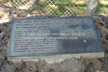
Photograph - Digital Photograph, Alan King, Plaque by the Hurst family cemetery, 1 February 2008
Plaque placed at a cairn erected in 1975 at the Hurst family cemetery at Hurstbridge in memory of people who were buried locally in unmarked graves. Transcription of plaque: This cairn was ereced in 1975 in memory of the following people who have been buried here in unmarked graves since 1866. Robert Thomas Hurst (father) Frances Facey Gurst (mother) Robert Hurst Ellen Hurst (Mrs Spencer) Fanny Hurst (Mrs Hawkins) Mr. Abbot-Christian name unknown Who was present when Henry was shot by the bushranger. An unnamed babe belonging to Catherine and Fred Hurst Ashes scatterd: Catherine Hurst (Fred's wife) Frances Ellen Hurst (Mrs Gray) William George Gray Published: Nillumbik Now and Then / Marguerite Marshall 2008; photographs Alan King with Marguerite Marshall.; p15This collection of almost 130 photos about places and people within the Shire of Nillumbik, an urban and rural municipality in Melbourne's north, contributes to an understanding of the history of the Shire. Published in 2008 immediately prior to the Black Saturday bushfires of February 7, 2009, it documents sites that were impacted, and in some cases destroyed by the fires. It includes photographs taken especially for the publication, creating a unique time capsule representing the Shire in the early 21st century. It remains the most recent comprehenesive publication devoted to the Shire's history connecting local residents to the past. nillumbik now and then (marshall-king) collection, hurst family cemetery, hurstbridge, memorial -
 Eltham District Historical Society Inc
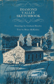
Book, Diamond Valley sketchbook / text by Brian McKinlay ; drawings by Graham Hawley, 1973
Contents include short articles and illustrations of historic properties within the municipalities of Banyule, Nillumbik and Whittlesea. Including The Griffin House, Rosehill, Lower Plenty, The Austin Hospital, Heidelberg, St John's Church, Heidelberg, Banyule, Heidelberg, Trestle Bridge, Eltham, Diamond Valley railway, The Shillinglaw Cottage, Eltham, Montsalvat, Old England Hotel, Heidelberg, Eltham Primary School, Mud brick homes, Eltham, Sweeney's Cottage, Eltham, Pound Pend Tunnel, The Gold Memorial, Potter's Cottage, Memorial Tower, Charterisville, Weller's Pub, The Barrel, Eltham, Hassall's Gallery, The Old Bridge, Greensborough, Diamond Valley Shire Offices, Greensborough, St Katherine's Chapel, Yan Yean Reservoir, Mernda Hotel, Mernda Mechanics Institute, Old Barn, Mernda, Parade College, La Trobe University.Hardback with jacket ; 63 p. : ill., maps ; 22cm. diamond valley shire, shire of nillumbik, city of whittlesea, city of banyule, shillinglaw cottage, weller's hotel -
 Eltham District Historical Society Inc
Photograph - Colour Print, Harry Gilham, Eltham Roll of Honour, Eltham War Memorial Hall, Nov 2004
The Eltham Roll of Honour Board was originally commissioned and paid for by the Eltham War Memorial Trust from funds raised by public donation. It was originally hung in the Infant Welfare Centre. In 1999 the Honour Roll Board was removed from the Eltham War Memorial by members of the RSL and relocated to the Eltham RSL sub-branch on Main Road. Following financial collapse of the Eltham RSL sub-branch and merger of the Eltham and Montmorency sub-branches and subsequent sale of the Eltham property, the WW1 obelisk was relocated to a location in front of the Eltham War Memorial. The Honour Roll Board was retrieved by former Eltham District Historical Society President, Harry Gilham in September 2004 who arranged for it to be re-hung in the Eltham War Memorial Hall (former Children's Library) where it was attached to the brick wall face of the west (rear) wall of the Hall (as seen in this photograph). Sometime around late 2018 when Council was investigating the potential sale and development of the Eltham War Memorial, the Eltham Honour Roll Board was once again removed from the Eltham War Memorial by persons unknown, under the pretext of ‘safekeeping,’ to a location outside of the Shire of Nillumbik, in the City of Banyule. In early 2021 Eltham District Historical Society was made aware of the removal of the Honour Roll Board. A formal request was made by EDHS to return this community asset to its rightful place as intended when it was commissioned and paid for by the Eltham War Memorial Trust. This request was rebutted. Nillumbik Shire Council has also since been made aware of the removal of this community asset and formally requested its return prior to Anzac Day, 2021 where it can once again be made accessible to members of the community to pay their respects as originally intended. As of July 2022, the Honour Board remains missing from its rightful place at the Eltham War Memorial. eltham war memorial hall, honour board, honour roll, roll of honour -
 Eltham District Historical Society Inc
Photograph, Liz Pidgeon, Heritage Excursion; Eltham Lower Park Walk and Talk, 1 July 2017
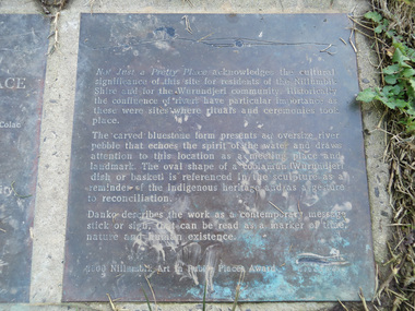
Transcription of plaque: Not Just a Pretty Place acknowledges the cultural significance of this site for residnets of the Nillumbik Shire and for the Wurundjeri community. Historically the confluence of rivers have particular importance as these were sites where rituals and ceremonies took place. The carved bluestone form presents an oversize river pebble that echoes the spirit of the water and draws attention to this location as a meeting place and landmark. The oval shape of a coolamun (Wurundjeri dish or basket) is referenced in the sculpture as a reminder of the indigenous heritage and as a gesture to reconciliation Danko describes the work as a contemporary message stick or sign, that can be read as a merker of time, nature and human existance. 2000 Nillumbik Art in Public Places Award. Heritage Excursion - Saturday 1st July - Eltham Lower Park - Walk and Talk Eltham Lower Park has played an important part in the history of our area since the early days of European settlement when it was used by local residents as an informal racecourse. Prior to that its location at the junction of the Diamond Creek and the Yarra River made it an important meeting place for the Wurundjeri people. The park combines formal elements and sporting facilities with remnant bushland that is of environmental significance. It is home to sporting and horse riding clubs, popular play spaces and the Diamond Valley Miniature Railway, which attracts large numbers of visitors. The park will be the venue for our July excursion which will comprise a walk of about 3.5 km around the park and adjacent areas. Along the way we will discuss the history and natural history of the area. The path along the creek and the river provides a pleasant and scenic walk. This walk on Saturday 1st July is about 3.5 km in length and will take 2 to 2.5 hours. It will start at 2pm at the Main Road car park at the front of the park. (Melway ref 21 H 10). From Newsletter No., 234, June 2017 Born Digitalelection day, heritage excursion, activities, eltham district historical society, eltham lower park, not just a pretty place, public art, plaque -
 Eltham District Historical Society Inc
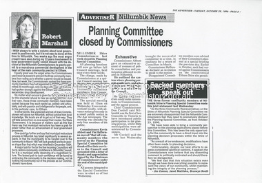
Document - News Clipping, Advertiser, Planning Committee closed by Commissioners, Advertiser, October 29, p5, 1996
Nillumbik Commissioners used 'reserve power's to permit a controversial Shell service station and Hungry Jack's restaurant development at the former Eltham Shire Office site at 895 Main Road. More than 200 people attended the Council meeting in the public gallery and protested at the decision. 32 personal submissions were made to Council's Planning Special Committee meeting whose members vioted 3-2 against the development. The Committee consisted of the three Nillumbik Commissioners and three community members (Jim Connor, Bronwyn South and Janet Mattiske). Chief Commissioner Don Cordell, a former Shell employee excused himself from voting and the three communbity memebrs voted against the submission. The other two commissioners, Vin Heffernan and Kevin Abbott voted against it. They then immediately closed the meeting and opened a Council meeting lasting just seconds to use special reserve powers to overturn the decision. Subsequent to this the Commissioner run Council held a special meeting on Wednesday, October 23, 1996 where Commissioners Kevin Abbott and Vin Heffernan thanked all three community members of the Planning Special Committee and advised that their powers had been revoked. The article includes a joint statement from all three sacked members in which they state they have been able to bring a community perspective to the planning applications placed befopre the committee which has resulted in modifications to planning decisions. The members stated that "unfortunately, despite our best efforts to express considered apolitical opinions, it appears the Commissioners believe that any dissenting comment is politically motivated, and should therefore be disregarded." "We feel sad that this situation exists even though we have done everything possible tio represent the views of our community, whilst maintaining the integrity of the planning process."The demolition of the former Shire of Eltham offices and proposed sale and development driven by the Commissioners for Nillumbik Shire Council brought the community together in substantial protest at the infrigement of ratepayers democratic say in local government and ciommunity assets combined with protests about inappropraite development of Eltham's Gateway. This issue led to the formation of the Eltham Community Action Group which still operates strongly today (2023) on behalf of the community to ensure appropriate development within the community.895 main road, commissioners, dallas price homes, development application, eltham hub, hungry jacks, nillumbik shire council, re-zoning, shell service station, town planning, eltham gateway, eltham gateway action group, eltham shire offices, shillinglaw farm, jim connor collection, dallas howgate, nillumbik planning special committee, jim connor, bronwyn south, janet mattiske, don cordell, vin heffernan, kevin abbott -
 Eltham District Historical Society Inc
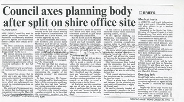
Document - News Clipping, Jodie Guest, Council axes planning body after split on shire office site, Diamond Valley News, October 30, p3, 1996
Nillumbik Commissioners used 'reserve power's to permit a controversial Shell service station and Hungry Jack's restaurant development at the former Eltham Shire Office site at 895 Main Road. More than 200 people attended the Council meeting in the public gallery and protested at the decision. 32 personal submissions were made to Council's Planning Special Committee meeting whose members vioted 3-2 against the development. The Committee consisted of the three Nillumbik Commissioners and three community members (Jim Connor, Bronwyn South and Janet Mattiske). Chief Commissioner Don Cordell, a former Shell employee excused himself from voting and the three communbity memebrs voted against the submission. The other two commissioners, Vin Heffernan and Kevin Abbott voted against it. They then immediately closed the meeting and opened a Council meeting lasting just seconds to use special reserve powers to overturn the decision. Subsequent to this the Commissioner run Council held a special meeting on Wednesday, October 23, 1996 where Commissioners Kevin Abbott and Vin Heffernan thanked all three community members of the Planning Special Committee and advised that their powers had been revoked. The article includes a joint statement from all three sacked members in which they state they have been able to bring a community perspective to the planning applications placed befopre the committee which has resulted in modifications to planning decisions. The members stated that "unfortunately, despite our best efforts to express considered apolitical opinions, it appears the Commissioners believe that any dissenting comment is politically motivated, and should therefore be disregarded." "We feel sad that this situation exists even though we have done everything possible tio represent the views of our community, whilst maintaining the integrity of the planning process."The demolition of the former Shire of Eltham offices and proposed sale and development driven by the Commissioners for Nillumbik Shire Council brought the community together in substantial protest at the infrigement of ratepayers democratic say in local government and ciommunity assets combined with protests about inappropraite development of Eltham's Gateway. This issue led to the formation of the Eltham Community Action Group which still operates strongly today (2023) on behalf of the community to ensure appropriate development within the community.895 main road, commissioners, dallas price homes, development application, eltham hub, hungry jacks, nillumbik shire council, re-zoning, shell service station, town planning, eltham gateway, eltham gateway action group, eltham shire offices, shillinglaw farm, jim connor collection, dallas howgate, nillumbik planning special committee, jim connor, bronwyn south, janet mattiske, don cordell, vin heffernan, kevin abbott -
 Eltham District Historical Society Inc
Photograph - Digital Photograph, Marguerite Marshall, Jelbart home, 93 Arthur Street, Eltham, 11 November 2006
Situated at the top of the hill in Arthur Street, the former Jelbart residence and barn were part of a major change that transformed Eltham's character in the late 1960s. Built from the mid 1940s through mid 1950s when Eltham was a rural community, the Jelbrat residence and barn are all that remain of a family property of some 250 acres (100 ha). With growing population pressures, in the late 1960s, owners Ron and Yvonne Jelbart decided to subdivide their property creating the Woodridge Estate in the early 1970s, a major factor towards the transformation of Eltham to the suburb it is today. The Jelbarts had moved to Eltham in the early 1940s when they purchased a poultry farm in New Street, now Lavendar Park Road. (The local Black Friday bushire of January 13, 1939 had started at C.A. (Clarrie) Hurst’s Eltham Poultry Farm and Hatchery in New Street.) Jelbart was primarily a businessman importing office machinery but desired farm beef and dairy cattle so the couple purchased the virgin bushland at what was then at the end of a dirt road, Arthur Street. With post war shortages of most building materials, they followed the example of the Eltham Artists' Colony (later called Montsalvat) and built thier home from mud-bricks and recyclked materials. The barn was first to be completed in 1945 which they made their home whilst building the main residence. It took eight years to complete the two buildings. Both the main residence and the barn are now separate homes, and along with the remaining property being sub-divided further in 1998 are now part of the Kinloch Gardens Estate at 93 Arthur Street. Covered under Heritage Overlay, Nillumbik Planning Scheme. Published: Nillumbik Now and Then / Marguerite Marshall 2008; photographs Alan King with Marguerite Marshall.; p139This collection of almost 130 photos about places and people within the Shire of Nillumbik, an urban and rural municipality in Melbourne's north, contributes to an understanding of the history of the Shire. Published in 2008 immediately prior to the Black Saturday bushfires of February 7, 2009, it documents sites that were impacted, and in some cases destroyed by the fires. It includes photographs taken especially for the publication, creating a unique time capsule representing the Shire in the early 21st century. It remains the most recent comprehenesive publication devoted to the Shire's history connecting local residents to the past. nillumbik now and then (marshall-king) collection, eltham, arthur street, jelbart barn, jelbart home, kinloch gardens -
 Eltham District Historical Society Inc
Photograph - Digital Photograph, Marguerite Marshall, Jelbart Barn, 93 Arthur Street, Eltham, 11 November 2006
Situated at the top of the hill in Arthur Street, the former Jelbart residence and barn were part of a major change that transformed Eltham's character in the late 1960s. Built from the mid 1940s through mid 1950s when Eltham was a rural community, the Jelbrat residence and barn are all that remain of a family property of some 250 acres (100 ha). With growing population pressures, in the late 1960s, owners Ron and Yvonne Jelbart decided to subdivide their property creating the Woodridge Estate in the early 1970s, a major factor towards the transformation of Eltham to the suburb it is today. The Jelbarts had moved to Eltham in the early 1940s when they purchased a poultry farm in New Street, now Lavendar Park Road. (The local Black Friday bushire of January 13, 1939 had started at C.A. (Clarrie) Hurst’s Eltham Poultry Farm and Hatchery in New Street.) Jelbart was primarily a businessman importing office machinery but desired farm beef and dairy cattle so the couple purchased the virgin bushland at what was then at the end of a dirt road, Arthur Street. With post war shortages of most building materials, they followed the example of the Eltham Artists' Colony (later called Montsalvat) and built thier home from mud-bricks and recyclked materials. The barn was first to be completed in 1945 which they made their home whilst building the main residence. It took eight years to complete the two buildings. Both the main residence and the barn are now separate homes, and along with the remaining property being sub-divided further in 1998 are now part of the Kinloch Gardens Estate at 93 Arthur Street. Covered under Heritage Overlay, Nillumbik Planning Scheme. Published: Nillumbik Now and Then / Marguerite Marshall 2008; photographs Alan King with Marguerite Marshall.; p139This collection of almost 130 photos about places and people within the Shire of Nillumbik, an urban and rural municipality in Melbourne's north, contributes to an understanding of the history of the Shire. Published in 2008 immediately prior to the Black Saturday bushfires of February 7, 2009, it documents sites that were impacted, and in some cases destroyed by the fires. It includes photographs taken especially for the publication, creating a unique time capsule representing the Shire in the early 21st century. It remains the most recent comprehenesive publication devoted to the Shire's history connecting local residents to the past. nillumbik now and then (marshall-king) collection, eltham, arthur street, jelbart barn, jelbart home, kinloch gardens -
 Eltham District Historical Society Inc
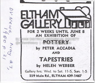
Document - Property Binder, 559 Main Road, Eltham
Newspaper advertisement: Diamond Valley News, 27 May 1980, Exhibition, Peter Accadia, pottery, and Helen Webber, tapestries. Newspaper article: Five for the price of one, Diamond Valley News, Tuesday, July 8, 1986, p27; exhibition of five artists at Eltham Gallery. On reverse, numerous advertisements for food and entertainment Newspaper advertisement: The Age ,17 June 1989, Exhibition, Donald Ramsay "Watching the river flow". Newspaper article: Landmark gallery says goodbye, Diamond Valley Leader, 24 November 2004, Gallery site sold to Sentinel Equities, present tenant Julie Skate, quotes from former part-owner Val Murray. Newspaper article: Rift over gallery plans, Diamond Valley Leader, 21 February 2007, purchasers Jethro Tull and Suzanne Still plan to build offices, gallery and cafe; Eltham Gateway Action Group objected while supporting need for a gallery elsewhere. Newspaper article: New try for gallery-cafe ready soon, Diamond Valley Leader, 18 April 2007, purchaser Jethro Tull to have a new plan ready in two weeks for gallery and cafe. Newspaper article: Gateway for artists, Diamond Valley Leader, 25 May 2007, Jenni Mitchell opened a new gallery pending decision by Nillumbik Council. Newspaper article: Art gallery proposal rejected, Diamond Valley Leader, 30 May 2007, Nillumbik Council against planned new building. Newspaper article: Artful win for gallery, Diamond Valley Leader, 30 January 2008, VCAT approved mudbrick art gallery. Newspaper article: Rocky road to create a landmark, Diamond Valley Leader, 13 February 2008, VCAT approved Robert Marshall's design, artists's impression, Eltham Gateway Action Group opposed.main road, property, businesses, eltham gallery, wiregrass gallery, eltham gateway action group, robert marshall, mud brick building, eltham (vic), 559 main road eltham, artists, bernhard rust, bob smith, jan neil, john adams, marian sussex, michael wilson, tony dopheide, 47-55 main street diamond creek, 50 were street montmorency, 55 rattray road montmorency, 410 main road lower plenty, abbey of diamond creek, adams north riding restaurant, advertising, eltham barrel, montmorency, mustard seed restaurant, peking house restaurant, st andrews, tamara's -
 Eltham District Historical Society Inc
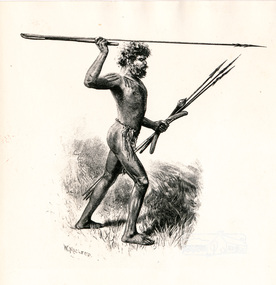
Photograph, Sketch of Aboriginal man with spears by W. Macleod
This black and white image appears on page 9 "Painters and Pioneers: One hundred years of Eltham and its Shire" by Alan Marshall (1971). (It is incorrectly acknowledged as S.T. Gill in the acknowledgements). It relates to Chapter 1 "The Beginning" and the description of explorer's Joseph Gellibrand journey through the area (and beyond) of the area now known as Eltham and wider Shire of Nillumbik. Gellibrand was accompanied by male aborigines. William Macleod (1850-1929) was a contributor to the "Picturesque Atlas of Australia" 1886. Described in "The Daily Telegraph" 21 June 1924 :"Macleod is a preserver of the scenic records of his own time, inasmuch as he has furnished posterity with many view of towns, rivers, and other localities, as they appeared in the years 1886-8. Among these, he has given us ...a blackfellow throwing a spear...' Image first published 1886. Image re-published in "Painters and Pioneers", 1971 pioneers and painters, aborigine, spear, drawing, william macleod, picturesque atlas of australia, aboriginal australian -
 Eltham District Historical Society Inc
Photograph - Digital Photograph, Alan King, Queenstown Cemetery, Smiths Gully Road, St Andrews, 28 December 2007
The discovery of gold in Smyth's Creek in 1854 and subsequent gold rush to the Caledonia diggings led to the establishment of Queenstown (present day St Andrews). The first recorded burial was July 31st, 1861 and it was officially declared a Cemetery Reserve in 1866. Many graves are unmarked and unrecorded including many Chinese and other itinerant miners. The cemetery was closed for new burials in 1851. The last recorded burial was in 1981 in an existing family grave. In Loving memory of David Band Died 30th Decr. 1862, aged 51 years. John Cork Knell Died 11th April 1867, aged 42 years. Eliza Smith Died 20th Jany. 1874, aged 3 1/2 years. William Band Died 20th Feby. 1883, aged 51 years. Published: Nillumbik Now and Then / Marguerite Marshall 2008; photographs Alan King with Marguerite Marshall.; p73This collection of almost 130 photos about places and people within the Shire of Nillumbik, an urban and rural municipality in Melbourne's north, contributes to an understanding of the history of the Shire. Published in 2008 immediately prior to the Black Saturday bushfires of February 7, 2009, it documents sites that were impacted, and in some cases destroyed by the fires. It includes photographs taken especially for the publication, creating a unique time capsule representing the Shire in the early 21st century. It remains the most recent comprehenesive publication devoted to the Shire's history connecting local residents to the past. nillumbik now and then (marshall-king) collection, david band, eliza smith, gravestones, john cork knell, queenstown cemetery, smiths gully road, st andrews, william band -
 Eltham District Historical Society Inc
Slide - Photograph, Eltham Courthouse, 730 Main Road, Eltham, c.May 1988
Built in 1860, the Eltham Courthouse is the oldest public building remaining in Eltham. In its early days the building was used as the meeting place and office of the Eltham District Road Board and as an overflow classroom for the local school. The Eltham Courthouse ceased operational duties in 1984 and is now used by various community groups including Eltham District Historical Society. It was listed on the Victorian Heritage Register (Number H0784) in 1982. The building is of architectural significance because it retains intact early features. These include use of handmade bricks, simple decoration, roof trusses, timber ceiling boards, original windows, doors and associated hardware and a collection of court furniture. Additions to the court house have been done in a manner which did not interfere with the fabric of the original building. It is a fundamental asset in the Eltham Justice Precinct and is being fully restored in 2021 thanks to Nillumbik Shire Council.35mm colour positive transparency (1 of 23) Mount - Kodak EktachromeProcess Date MAY 88Meltham, eltham courthouse, main road -
 Eltham District Historical Society Inc
Photograph, Peter Pidgeon, Landscape with sheep by Walter Withers part of the Heidelberg Artist Trail, 2 Sep 2017
The Heidelberg School Artists Trail was established in about 1999 with about 52 signs across four local governemnt areas including Nillumbik and Banyule. This one acknowledges "Landscape with Sheep" by Walter Withers. The text on the board states: Walter Withers depicts in this work a number of sheep on Mr. Tom Orr’s property. Our view is from the rise above this park, from the Lower Plenty side of the nearby Diamond Creek, looking northwards towards the main Eltham township. The area that is now Wingrove Park, would have been to the right, in the valley below the sheep. The mood of this work is warm and vibrant, with the use of strong blues and pinks, and this stands in marked contrast to the softer, cooler greens used by Walter Withers in his work ‘The Silent Gums’. Heritage Excursion by EDHS members - An Eltham South Ramble, 2 Sep 2017Born Digitalactivities, eltham district historical society, eltham south, heritage excursion, local history centre, eltham, heidelberg artists' trail, walter withers, landscape with sheep, wingrove park trail -
 Eltham District Historical Society Inc
Photograph, Peter Pidgeon, Heidelberg Artists Trail signs are through this area including local artist Walter Withers, 2 Sep 2017
The Heidelberg School Artists Trail was established in about 1999 with about 52 signs across four local governemnt areas including Nillumbik and Banyule. This one located in Wingrove Park Eltham pays tribute to Walter Withers and his painting "The Silent Guns" Transcription of sign: Walter Withers – The Silent Gums, 1909 Walter Withers painted this tranquil pastoral scene in the vicinity this park. Here he has captured the dairy cattle belonging to local Eltham farmer, Mr. Tom Orr, feeding and resting in the shade of the tall Manna gums. Wither’s daughter, Nan recalled how her father, for inspiration, often visited the property of their neighbour, Mr. Tom Orr, and in his later years, Withers painted many landscapes depicting Mr Orr’s sheep and dairy cattle. Heritage Excursion by EDHS Members - An Eltham South Ramble, 2 Sep 2017Born Digitalactivities, eltham district historical society, eltham south, heritage excursion, local history centre, walter withers, heidelberg artists' trail, wingrove park trail, the silent gums -
 Eltham District Historical Society Inc
Photograph - Digital Photograph, Marguerite Marshall, Rice House, 69 Ryans Road, Eltham, 27 March 2007
Built in 1953, the Rice House was leading Melbourne architect Kevin Borland's first commssion and was one of two houses of its kind. The design of the shell-like structure was inspired by the Arch of Ctesiphon, built in the second century south of Baghdad. Cement with a waterproofing agent was applied in layers to a form of regularly spaced timber arches covered in hessian. This ctesiphon system was developed in the United Kingdom by engineer J.H. de Waller in 1947. Commissioned in 1951 by Harrie and Lorna Rice, after Harrie, then an art student, met Borland at The Age Small Homes Service. Borland suggested they buy land in Eltham because at that time it was the only council in Melbourne that would grant a permit for such an innovative house. Covered under Victorian Heritage. Published: Nillumbik Now and Then / Marguerite Marshall 2008; photographs Alan King with Marguerite Marshall.; p157This collection of almost 130 photos about places and people within the Shire of Nillumbik, an urban and rural municipality in Melbourne's north, contributes to an understanding of the history of the Shire. Published in 2008 immediately prior to the Black Saturday bushfires of February 7, 2009, it documents sites that were impacted, and in some cases destroyed by the fires. It includes photographs taken especially for the publication, creating a unique time capsule representing the Shire in the early 21st century. It remains the most recent comprehenesive publication devoted to the Shire's history connecting local residents to the past. nillumbik now and then (marshall-king) collection, eltham, rice house, ryans road -
 Eltham District Historical Society Inc
Document - Folder, Nixon, Bruce
Walter Bruce Nixon (20.11.1934-8.9.2012) lived at Yarra Glen and was a bus line owner. He also ran a company, Tarcoola Press, which published books on the history of the Nillumbik and Yarra Valley area, and generously supported organisations such as the Andrew Ross Museum and the C J La Trobe Society. Contents Newspaper article: "Revealed: the stark beauty of an early settlement", The Age, 19 November 1999, Bruce Nixon underwrote publication of a book of C J La Trobe's drawings and paintings of Melbourne. Newsletter extract: "Bruce Nixon: a boyhood in Ivanhoe", Heidelberg Historian No.270 June 2012, Bruce Nixon's memories of growing up in Ivanhoe from the 1930s and on Mick Woiwod's books. Order of Service: Walter Bruce Nixon, 14 September 2012. Flier: "Recent works by Mick Woiwod", notes the support provided by Bruce Nixon.Newspaper clippings, A4 photocopies, etcbruce nixon, charles joseph la trobe, tarcoola press, waterdale road ivanhoe, ivanhoe state school, knox church ivanhoe, ivanhoe swimming club, donaldson family of kangaroo ground, thomson family of kangaroo ground, james bruce donaldson, james thomas donaldson, john donaldson, wallace thomson, george donaldson, james williams bushranger, andrew ross, andrew ross museum, mick woiwod, wurundjeri people of kangaroo ground, coranderrk healesville, walter bruce nixon -
 Eltham District Historical Society Inc
Photograph - Digital Photograph, Alan King, Former St Andrews State School No. 128 building, 23 January 2008
In 1858 the Caledonia Common School No.128 opened at Queenstown, about 1.6km upstream on Diamond Creek from the present site of the old St Andrews school. The school was renamed Queenstown Common School No. 128 in 1867. In 1882, due to declining numbers of pupils at Smiths Gully and increasing numbers in Queenstown the school was moved from a leased building, owned by Head Teacher Robert Harris, into a new larger building on the corner of School and Heidelberg-Kinglake roads which incorporated the original single room school building, which had been moved from Smiths Gully, and included a teacher’s three-roomed residence. In 1887 the school was replaced by the Queenstown State School No. 128. The school and town were renamed St Andrews in 1952. In 1983 a new school was built, 500 metres south of the old school and the old school became the St Andrews Community Centre. Of significance is the c1887 school building (including part of the c1876 Smith's Gully school moved to the site and incorporated into the c1887 school building), the c1911 new room, the c1929 cloakroom, the c1930 renovations, the c1956 new infant room; the c1961 office and storeroom, as well as the c1950 Himalayan Cedar tree and the entire site to the title boundaries. The school building is historically significant for its links with the early settlement of the area and because its use of materials from the former Smith's Gully State school illustrates the common 19th and early 20th century practice of relocating State school buildings based on need. The school building is historically and socially significant because it served the local community, as a school, from 1887 to the late 1970s/early 1980s and because since then it has been used for other community purposes. Covered under Heritage Overlay, Nillumbik Planning Scheme. Published: Nillumbik Now and Then / Marguerite Marshall 2008; photographs Alan King with Marguerite Marshall.; p69This collection of almost 130 photos about places and people within the Shire of Nillumbik, an urban and rural municipality in Melbourne's north, contributes to an understanding of the history of the Shire. Published in 2008 immediately prior to the Black Saturday bushfires of February 7, 2009, it documents sites that were impacted, and in some cases destroyed by the fires. It includes photographs taken especially for the publication, creating a unique time capsule representing the Shire in the early 21st century. It remains the most recent comprehenesive publication devoted to the Shire's history connecting local residents to the past. nillumbik now and then (marshall-king) collection, st andrews, queenstown state school no. 128, smiths gully state school -
 Eltham District Historical Society Inc
Photograph - Digital Photograph, Alan King, Eltham Living and Learning Centre, 26 January 2008
In 1857, tanner John Pearson purchased three and a half acres of land in Little Eltham, at the western end of Pitt Street, with a 70-foot frontage to Maria Street (Main Road) and stretching down to the Diamond Creek for £100. He contracted Benjamin Oliver Wallis to build house for him. Wallis, a mason by trade who originated from the Cornish village of Newlyn, migrated to Melbourne in 1853 and was shortly engaged by Richard Warren to build the Eltham Hotel, which opened in 1854. When Warren fell into financial difficulty in 1858, Wallis purchased the hotel. That same year, Pearson constructed a tannery below the house with access to the water in the Diamond Creek. When Pearson became bankrupt in 1867, Wallis similarly acquired the house from Pearson’s creditors in 1868 and lived there until his death in 1896. For some of this time the house was in the name of Wallis’s son Richard but following his death in 1888, ownership reverted to his father. It was purchased by retired teacher Richard Gilsenen in 1899. Gilsenen was made acting head teacher at the Eltham State School in 1906 following the sudden death of head teacher John Brown. In the 1950s the house was bought by retired engineer Dr Alfred Fitzpatrick and his wife Claire who made various modifications to house goats and poultry as well as structural modifications to the house. In the early 1970s, Eltham Shire Councillors Frank Maas and Don Maling proposed an extended communities’ activities program be set up and the Commonwealth Grants Commission was approached for financial assistance. In 1974 a $50,000 Commonwealth Grant was received by the Shire Council to acquire the Fitzpatrick property as part of the planning to establish an extended communities’ activities program. The Fitzpatricks moved next door and Claire taught at the new Living and Learning Centre, which began in 1975, one of the first community education centres in Victoria. Covered under Heritage Overlay, Nillumbik Planning Scheme. Published: Nillumbik Now and Then / Marguerite Marshall 2008; photographs Alan King with Marguerite Marshall.; p59This collection of almost 130 photos about places and people within the Shire of Nillumbik, an urban and rural municipality in Melbourne's north, contributes to an understanding of the history of the Shire. Published in 2008 immediately prior to the Black Saturday bushfires of February 7, 2009, it documents sites that were impacted, and in some cases destroyed by the fires. It includes photographs taken especially for the publication, creating a unique time capsule representing the Shire in the early 21st century. It remains the most recent comprehenesive publication devoted to the Shire's history connecting local residents to the past. nillumbik now and then (marshall-king) collection, benjamin oliver wallis, claire fitzpatrick, don maling, dr alfred fitzpatrick, eltham living and learning centre, frank maas, john pearson, richard gilsenen, tannery -
 Eltham District Historical Society Inc
Audio Recording, Audio Recording; 2016-04-14 Jane Woollard and Laughing Waters Road, 14 Apr 2016
April Meeting (Newsletter No. 227, Apr. 2016) At this meeting we are pleased to have as our guest speaker Jane Woollard, who has just published a book titled ‘Laughing Waters Road: Art, Landscape and Memory in Eltham.’ Jane was the local history officer at the Shire of Nillumbik so has a detailed knowledge of the history of our area. She has an extensive background as a writer, theatre director and teacher. As well as directing over 50 productions Jane has been a tutor and guest director at the Victorian College of the Arts and La Trobe University and was Artistic Director of the Union House Theatre at the University of Melbourne. Since 2001 more than eighty artists have been in residence at Laughing Waters in Birrarung House and Riverbend. In her book Jane has woven together their experiences and art making, together with Wurundjeri, European and family histories to create an evocative account of a very special place in Eltham.0:47:13 duration Digital MP3 File 66 MB audio recording, birrarung house, eltham district historical society, jane woollard, laughing waters, riverbend, shire of nillumbik, society meeting, wurundjeri -
 Eltham District Historical Society Inc
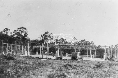
Photograph, Diamond Creek Tennis Club, Diamond Street, Diamond Creek, c.1926
New tennis courts on Diamond Street, Diamond Creek. The car belongs to Dr. E. Cordner Senior who was a keen tennis and football player. The courts were originally located at a site below Fyffe Street but were demolished when railway construction began in 1911. - Yarra Plenty Regional Library (via Picture Victoria) http://www.picturevictoria.vic.gov.au/site/nillumbik/NillumbikLocalHistoryDigitisationProject/6918.html The official opening of the Diamond Creek Tennis Club was on Saturday, December 2nd, 1922 where Dr. E. R./ Cordner (President) presided. 1922 'Diamond Creek.', Advertiser (Hurstbridge, Vic. : 1922 - 1939), 8 December, p. 2. (AFTERNOON), viewed 16 Feb 2020, http://nla.gov.au/nla.news-article56637465 The car belonging to Dr Cordner is a Ford Model T. The first Australian made Model T came off the production line in Geelong, 1 July, 1925. Black and white copy of photo printed on glossy photographic paper 30.5 x 40.5 cm (12 x 16 inch); image size approx. 18.5 x 28 cmcar, diamond creek, diamond creek tennis club, diamond street, dr edward rae cordner snr, ford model t, motor vehicles -
 Eltham District Historical Society Inc
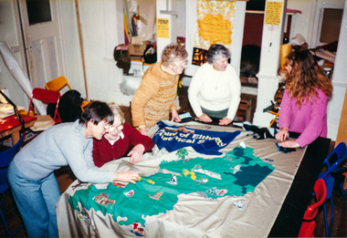
Photograph, Working on the Society Banner at Meruka House, Shire of Eltham, "As We Are" Community Banner Project, 1986
Tracey Naughton was the former Shire of Eltham Community Arts Officer and was responsible for developing the 'As We Are' project which encouraged a number of local community groups to develop banners. The Society was keen to be involved and the project was kicked off following a talk to the Society's members by Tracey in April 1986. The banner was completed and displayed with a number of other banners at the Eltham Community Centre in October 1986. It was then carried proudly for the first time in front of the Society's Parade Float in the 1986 Eltham Community Festival Parade and subsequent parades through to 1990. In December 1994 the Shire of Eltham ceased to exist and following council amalgamation and the establishment of the new Shire of Nillumbik, the Society's name (Shire of Eltham Historical Society) had become somewhat irrelevant and it was revised in 1995 to Eltham District Historical Society. The immediate downstream impact of this change was the rendering of the Society's Banner to history after only eight years of use. The banner now hangs proudly in our Local History Centre.Five colour photographsactivities, banner project, meruka house, jud deegan, marjorie north, blanche shallard, lu robertson, russell yeoman, opal smith -
 Eltham District Historical Society Inc
Photograph, Shire of Eltham Historical Society Community Banner
Tracey Naughton was the former Shire of Eltham Community Arts Officer and was responsible for developing the 'As We Are' project which encouraged a number of local community groups to develop banners. The Society was keen to be involved and the project was kicked off following a talk to the Society's members by Tracey in April 1986. The banner was completed and displayed with a number of other banners at the Eltham Community Centre in October 1986. It was then carried proudly for the first time in front of the Society's Parade Float in the 1986 Eltham Community Festival Parade and subsequent parades through to 1990. In December 1994 the Shire of Eltham ceased to exist and following council amalgamation and the establishment of the new Shire of Nillumbik, the Society's name (Shire of Eltham Historical Society) had become somewhat irrelevant and it was revised in 1995 to Eltham District Historical Society. The immediate downstream impact of this change was the rendering of the Society's Banner to history after only eight years of use. The banner now hangs proudly in our Local History Centre.Colour photographactivities, banner project -
 Eltham District Historical Society Inc
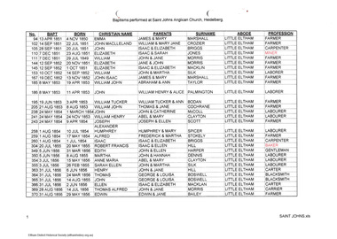
Folder, Eric Tetlow, Baptisms performed at St John's Anglican Church Heidelberg, 2006
List of baptisms of Little Eltham residents 1850-1860 and Diamond Creek 1850-1862 at St John's Anglican Church Heidelberg. Includes names of about 80 children whose abode was given as Diamond Creek or Little Eltham. Printout of spreadsheet listing number, date of baptism, birth date, christian name, names of parents, abode and profession. Baptisms performed at Saint John's Anglican Church Heidelberg. Arranged in date order. Includes hand written contextual notes by Harry Gilham. Copy provided to Jock Ryan, President of the Nillumbik Historical Society in 2006. Additional notes by Harry Gilham, 2012: Compiled by the late Eric Tetlow, Secretary, Yarra Glen and District Historical Society who, working at St John's Church of England Heidelberg in their archives in 2006, discovered files which he colated into this spreadsheet document of Baptisms relating to Little Eltham and Diiamond Creek. St John's Heidelberg is the original source of information.A significant resource which pulls together names of pioneer families for the area during its early European settlement.4 pagesHG Booklet 41harry gilham collection, st john's anglican church heidelberg, diamond creek, armstrong, bailey, bennett, benson, blackman, bodan, booth, bozwell, briggs, chad, clark, clayton, cochrane, crozier, dennis, ewing, fowler, haley, harper, heley, hill, irish, jones, kaylock, kerr, keylock, macklin, mccoll, mitchell, morris, palmington, scott, silk, spicer, stokely, taylor, thornburn, thorborne, waterton, wills, marshall, little eltham -
 Eltham District Historical Society Inc
Document, Appointment of New Trustees, Eltham Public Hall, Lot 20 Henry Street, Eltham, 1940
Draft of Indenture made __ day of __ 1940 between William Allen, Nurseryman, Ernest James Andrew, Gentleman, Ronald Walter Bradbury, Medical Practioner, Robert Sutherland Bryan, John Neville Burgoyne, Grocer, James Francis Cresp, Frederick Haines Collis, Grocer, William Hickey, Harold Claude Hutchison, David Andrew Lyon, Garage Proprietior, Albert E. Parsons, James Clyde Rains, News Agent, Eric Nicholl Staff, Store-keeper and William Walker, Plumber all of Eltham in the State of Victoria and Anton William Brinkkotter, Poultry Farmer in the said State and Sidney William Browne, Hotel Proprietor of Lower Plenty and Robert David Taylor, Secretary of Rosanna (the Committee) to appoint John Neville Burgoyne, William Hickey and David Andrew Lyon as Trustees to replace William James Capewell, Ernest James Andrew and George Birchall. William James Capewell, Butcher and Ernest James Andrew, News Agent and both of Eltham and George Harrison were the original Trustees appointed in the Declaration of Trust dated 5 August 1922. George Birchall replaced George Harrison 6 August 1925 but after being absent from the State for more than two years and William James Capewell and Ernest James Andrew desirous of being discharged as Trustees, under the power of appointing new Trustees vested in the Committee, the Committee resolved on 14 November 1935 that Albert Henry Charles Price, Cecil Martin and Albert John Fahle should be Trustees in place of George Birchall, Ernest James Andrew and William James Capewell however the said resolution was never carried into effect and the said writing was never completed. Subsequently in 1940 Albert Henry Charles Price, Cecil Martin and Albert John Fahle each resigned in writing as Trustees even though never appointed and so the Committee appointed John Neville Burgoyne, William Hickey and David Andrew Lyon as Trustees in place of William James Capewell, Ernest James Andrew and George Birchall. Originally purchased in 1856 from Thomas Roberts, Yeoman of Little Eltham, for £10 for use by the Wesleyan Chapel, represented by indentured Trustees, Rev. Barnabas Shaw Walker, Minister of the Pentridge Circuit, Francis Thomas, Farmer of Keelbundora, William Harriman, Blacksmith of Nillumbik, Nicholas Rodda, Farmer of Nillumbik, Aaron Grimshaw, Farmer of Greensborough, Joseph Cooper, Gardener of Keelbundora, Peter Dredge, Scholmaster of Jika Jika and Samuel Jeffrey, Farmer of Jika Jika. Lot 20 of Subdivision of Portion 13, Section 4 of the Parish of Nillumbik in the County of Evelyn was located on the southern side of Henry street in Little Eltham North, where the current Our Lady Help of Christians Catholic Church is situated. It became the location of the Eltham Rechabite Hall. In 1893 a new hall was built and further enlarged in 1919. At the commencement of 1922, the property was purchased from the Independent Order of Rechabites with publicly subscribed funds and a new hall built at a cost of £750 and improved road access constructed to reduce the grade, running from Dudley Street to Henry Street. This hall was eventually replaced with the new Shire Offices and Hall built on the corner of Arthur Street and Main Road, which was opened in 1941. Traces the earliest history of the Eltham Public Hall in Henry Street and the various names, occupations and abodes of the Trustees associated with the propertyalbert e. parsons, albert henry charles price, albert john fahle, anton william brinkkotter, cecil martin, david andrew lyon, eltham public hall, eltham rechabite hall, eltham wesleyan chapel, eric nicholl staff, ernest james andrew, frederick haines collis, george birchall, grocer, harold claude hutchison, henry street, james clyde rains, james francis cresp, john neville burgoyne, robert david taylor, robert sutherland bryan, ronald walter bradbury, sidney william browne, trustee, william allen, william hickey, william james capewell, william walker -
 Eltham District Historical Society Inc
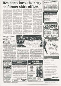
Document - News Clipping, Jodie Guest, Residents have their say on former shire offices, Diamond Valley News, October 16, p9, 1996
Nillumbik Commissioners used 'reserve power's to permit a controversial Shell service station and Hungry Jackls restaurant development at the former Eltham Shire Office site at 895 Main Road. More than 200 people attended the Council meeting in the public gallery and protested at the decision. 32 personal submissions were made to Council's Planning Special Committee meeting whose members vioted 3-2 against the development. The Committee consisted of the three Nillumbik Commissioners and three community members (Jim Connor, Bronwyn South and Janet Mattiske). Chief Commissioner Don Cordell, a former Shell employee excused himself from voting and the three communbity memebrs voted against the submission. The other two commissioners, Vin Heffernan and Kevin Abbott voted against it. They then immediately closed the meeting and opened a Council meeting lasting just seconds to use special reserve powers to overturn the decision. Community residents who made submissions included Russell Yeomans speaking on behalf of the Eltham Gateway Action Group and Eltham District Historical Society, Des Ryan on belaf of Eltham Senior Citizens, Angela Newhouse, others on behalf of Our Lady Help of Christians Primary School and Judge Book Village, Tom Munro, Ian Jennings, Margartet Ball a fifth generation descendant of the Shillinglaw family, one of the early settlers of the area and owner of the land that was sold to Council, Frank Burgoyne who said "there will be a lot of creaking and rumbling in the cemetery if this goes through. So many old people who have done so much for Eltham are buried up there and it is up to us to pass on what they left to the younger generation. Eltham is a beautiful spot; why louse it up?" A second article "Anger over reserve power" by Laeta Antonysen provides commentary from the three Planning Special Committee community members, former Eltham Shire Councillor Jim Connor, Bronwyn South and Janet Mattiske about the process that took place and the first time use of the spoecial reserve power to overturn the decision of the committee. Barry Rochford, Nillumbiuk CEO defends the use of the power.The demolition of the former Shire of Eltham offices and proposed sale and development driven by the Commissioners for Nillumbik Shire Council brought the community together in substantial protest at the infrigement of ratepayers democratic say in local government and ciommunity assets combined with protests about inappropraite development of Eltham's Gateway. This issue led to the formation of the Eltham Community Action Group which still operates strongly today (2023) on behalf of the community to ensure appropriate development within the community.895 main road, commissioners, dallas price homes, development application, eltham hub, hungry jacks, nillumbik shire council, re-zoning, shell service station, town planning, eltham gateway, eltham gateway action group, eltham shire offices, shillinglaw farm, shillinglaw trees, jim connor collection, dallas howgate, nillumbik planning special committee, jim connor, bronwyn south, janet mattiske, don cordell, vin heffernan, kevin abbott, russell yeomans, eltham district historical society, eltham senior citizens, des ryan, our lady help of christians primary school, judge book village, angela newhouse, tom munro, ian jennings, margaret ball, shillinglaw cottage, frank burgoyne, andrew biasci, barry rochford