Showing 11146 items matching "planning "
-
 Port Melbourne Historical & Preservation Society
Document - File, Port Melbourne Yacht Club, 1970s - 1990s
Port Melbourne Yacht Club .01 -Sewerage connection 1975 - including plans .02 - PMYC expansion report. Original 1976 including plans and photos .03 - Rebuilding of clubhouse 1992. Including plans sport - yachting, built environment - recreational facilities -
University of Melbourne, Burnley Campus Archives
Plan, Yates Landscape Details - Mr & Mrs Yates, 1993
Plans by John Patrick Pty. Ltd. (1) Tracing paper plan, Yates Landscape Details DRG No P9235-L3. Drawn by M.P. 12.1.93. (2) Tracing paper plan, Irrigation Plan DRG No P9235-L3. Scale 1:100. Drawn by M.P. 20.8.93. (3) Tracing paper plan, Yates Planting and Layout DRG No 9235-L1. Drawn by M.P. 6.1.93.john patrick pty. ltd., hawthorn, yates, landscape design -
 Bendigo Historical Society Inc.
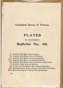
Book - MCCOLL, RANKIN AND STANISTREET COLLECTION: PLATES TO ACCOMPANY BULLETIN NO.49 MALDON GEOLOGICAL SURVEY OF VICTORIA
Book; Brown paper containers with plates (& maps) to accompany bulletin No49 of geological survey of Victoria. V Oswalds G.M. Plan of lease. VI. Oswalds G. M. Plan of workings. VII. Oswalds G. M. Transverse Sect. VIII. Oswalds G. M. Longit. Section. IX. Oswalds G. M. Plan & Sect. 500ft. Level. X. Northey's Reef plan & sections. XI. Carlisle and Whittaker's Mine Plan & Sections.XII. Goldsborough G. M. Co. Gordon's Reef, Plan & Section. XIII. Mount Tarrengower Tunnel Plan & Section.MCCOLL RANKIN & STANISTREETorganisation, industry, surveys, mccoll rankin & stanistreet -
Whitehorse Historical Society Inc.
Document, Special Council Meeting, 1994
Special Council meeting 28 Nov 1994. Notice and agendas of meetings to be held in the Council Chamber, Civic Centre, Nunawading.Special Council meeting 28 Nov 1994. Notice and agendas of meetings to be held in the Council Chamber, Civic Centre, Nunawading. Corporate Business Special Committee, Finance Special Committee and Forward Planning Committee. Includes papers re East Burwood Reserve, Nunawading Basketball Centre, East Burwood Plaza Shopping Centre.Special Council meeting 28 Nov 1994. Notice and agendas of meetings to be held in the Council Chamber, Civic Centre, Nunawading.local government, city of nunawading, east burwood reserve, nunawading basketball centre, east burwood plaza shopping centre -
 Bacchus Marsh & District Historical Society
Map, Rough plan showing proposed deviation of road through McKenzie's Flat
The date of this map or plan is uncertain. McKenzie's Flat is a bushland picnic area on the Lerderderg River in the Lerderderg State Park close to Bacchus Marsh. Single page map showing a proposed deviation of the road near the McKenzie's Flat area close to Bacchus Marsh. The proposed deviation is shaded in pink, The existing road section to be replaced is shaded in blue. No scale is indicated. Part of a set of maps which are pasted into a bound volume containing 76 maps or plans in total. High resolution digital image stored on BMDHS computer network. mckenzies flat bacchus marsh, bacchus marsh roads and streets -
 Kew Historical Society Inc
Plan - Subdivision Plan, Bonnie Doon Estate, c.1908
Pru Sanderson, in her groundbreaking ‘City of Kew Urban Conservation Study : Volume 2 - Development History’ (1988), summarised the periods of urban development and subdivisions of land in Kew. The periods that she identified included 1845-1880, 1880-1893, 1893-1921, 1921-1933, 1933-1943, and Post-War Development. These periods were selected as they represented periods of rapid growth or decline in urban development. An obvious starting point for Sanderson’s groupings involved population growth and the associated economic cycles. These cycles also highlighted urban expansion onto land that was predominantly rural, although in other cases it represented the decline and breakup of large estates. A number of the plans in the Kew Historical Society’s collection can also be found in other collections, such as those of the State Library of Victoria and the Boroondara Library Service. A number are however unique to the collection.The Kew Historical Society collection includes almost 100 subdivision plans pertaining to suburbs of the City of Melbourne. Most of these are of Kew, Kew East or Studley Park, although a smaller number are plans of Camberwell, Deepdene, Balwyn and Hawthorn. It is believed that the majority of the plans were gifted to the Society by persons connected with the real estate firm - J. R. Mathers and McMillan, 136 Cotham Road, Kew. The Plans in the collection are rarely in pristine form, being working plans on which the agent would write notes and record lots sold and the prices of these. The subdivision plans are historically significant examples of the growth of urban Melbourne from the beginning of the 20th Century up until the 1980s. A number of the plans are double-sided and often include a photograph on the reverse. A number of the latter are by noted photographers such as J.E. Barnes.The subdivision advertised as the Bonnie Doon Estate in Greensborough was first advertised in 1908. At that stage, the new subdivision included 15 allotments of between one and four acres. By the time the subdivision plan in the Kew Collection was created, only 12 lots of between ¾ and 2½ acres remained. Both the State Library and Kew plans emphasise the distance to the city being 13½ miles, which could be reached by train on weekdays and weekends. Unusually, the plan describes the suitability of lots as locations for ‘Week-end Homes’. Correspondingly, the train line is described as ‘The Holiday Resort for the Northern Suburbs’.bonnie doona estate, subdivision plans - greensborough -
Kew Historical Society Inc
Plan - Charteris Estate, Ivanhoe [East], 1927
Subdivision plans and real estate flyers/brochures reveal a number of aspects of urban development and history. The Kew Historical Society's collection of these plans, as well as advertisements extracted from magazines, cover key aspects of community development and architectural history of Kew and Kew Eat as well as surrounding suburbs. While most of the plans in the collection were gifted to the Society by the former City of Kew, a number of other plans and advertisements have been donated by individuals, of which this is an example.Original 4-page bifold handout advertising 43 residential lots for sale in the Charteris Estate subdivision in Ivanhoe [now classified as Ivanhoe East]. This brochure was created to sell the third section of the estate which it labels as 'The Most Superb Section'. Streets within the subdivision include: Burke Road North, McArthur Road, Castella Street, and the Government Boulevard. In addition to the overall plan spread across pages 2 and 3, each page includes a number of interesting photographs including: a number of the new Burke Road Bridge, a sports ground, Hoyts Picture Theatre in Ivanhoe, a croquet ground, and Ivanhoe shopping centre [named Motor Cross Junction].charteris estate - east ivanhoe (vic), subdivision plans -- ivanhoe east (vic.), d.c. mcarthur, charterisville -
 Federation University Historical Collection
Plan - Plans, Ballarat School of Mines Old Chemistry Building Refurbishment Plans
The Old Chemistry Building on the Federation University Australia SMB campus is one of the earliest remaining buildings used at the Ballarat School of Mines.Digital copies of refurbishment plans for University of Ballarat's refurbishment plans for the Old Chemistry Building, Ballarat School of Mines Campus.ballarat school of mines, old chemistry building, refurbishment, smb campus -
Federation University Historical Collection
Plan, Ballarat - Mining Lease No 5611
Plan showing mining lease no 5611 along Yarrowee Creek, Ballarat. Bonshaw Pre-Emptive Right is recorded on the plan.ballarat, yarrowee, yarrowee creek, mining, mining lease, ballaarat, bonshaw, magpie, pre-emptive right -
 Flagstaff Hill Maritime Museum and Village
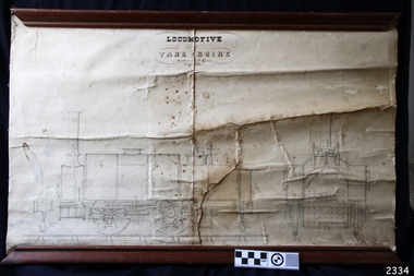
Plan
Plan of locomotive tank engine drawn by A. Kerr 1852. This plan is attached to canvas, and has wooden rails, top and bottom.flagstaff hill, warrnambool, shipwrecked-coast, flagstaff-hill, flagstaff-hill-maritime-museum, maritime-museum, shipwreck-coast, flagstaff-hill-maritime-village, locomotive tank engine, a. kerr -
 Federation University Historical Collection
Plans, Wimmera College of Technical and Advanced Education, 1983
.1) 14 pages bound printed plans: Developed Sketch Plans for Horsham Technical School .2) Duplicate as above wimmera college of tafe, horsham technical school, plans, architectural plan -
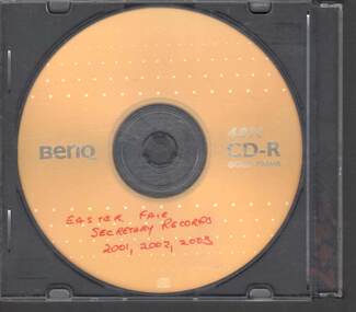 Bendigo Historical Society Inc.
Administrative record - EASTER FAIR SECRETARY RECORDS, 2001
CD containing Bendigo Easter Fair secretary records for years 2001,2002, and 2003. Management Plans, financial and planning records.bendigo, institutions, easter fair -
Port Melbourne Historical & Preservation Society
Plan - Port Melbourne Yacht Club reconstruction, Taylor Howden Pty Ltd, Architects, c. 1990
Clubhouse burned 14 February 1990 and was rebuilt with volunteer labour over many years (opened 1998)Plan of Port Melbourne Yacht Club clubhouse reconstruction 1990 Plan of clubhouse prior to 1990; faded almost to illegibilitybuilt environment - recreational facilities, societies clubs unions and other organisations, port melbourne yacht club, pmyc -
Port Melbourne Historical & Preservation Society
Plan - Port Melbourne Yacht Club reconstruction, Taylor Howden Pty Ltd, Architects, c. 1990
Clubhouse burned 14 February 1990 and was rebuilt with volunteer labour over many years (opened 1998)Plan of Port Melbourne Yacht Club clubhouse reconstruction 1990 - PMYC site and location plan; faded almost to illegibilitybuilt environment - recreational facilities, societies clubs unions and other organisations, port melbourne yacht club, pmyc, taylor howden pty ltd -
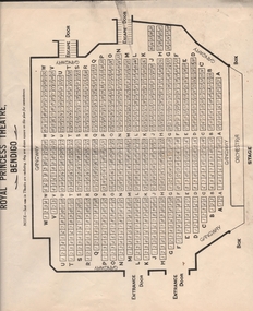 Bendigo Historical Society Inc.
Document - ROYAL PRINCESS THEATRE COLLECTION: SEATING PLANS
Seven sheets of paper showing plans of stalls, box plan and dress circle plann of the Royal Princess Theatre - Bendigo.bendigo, buildings, princess theatre -
Whitehorse Historical Society Inc.
Legal record - Illustration, Display Centre
Architect's outline plans of Display Centre for Schwerkolt Cottage. IArchitect's outline plans of Display Centre for Schwerkolt Cottage. Includes elevations and plan. Differs in detail from final building.Architect's outline plans of Display Centre for Schwerkolt Cottage. Ischwerkolt cottage & museum complex, architect plans -
Lakes Entrance Historical Society
Book, Department of Conservation and Environment, Lake Tyers Foreshore Reserves Management Plan, 1991
An approved management plan relating to the public foreshore land between Lake Bunga and Mill Point. Contains plans and appendices.waterfront, vegetation -
University of Melbourne, Burnley Campus Archives
Plan, Duck Pens at Burnley Competitions. Plan of Floor No 1, c. 1940
Hand drawn plan, coloured. Plan of Floor of Duck Pens with Level for Drain. Imperial measurements, so before 1966.duck pens, drainage -
 Kew Historical Society Inc
Photograph - Cottage, probably East Kew, A. Aberline, 1920s
The Kew Historical Society's map collection includes a substantial number of real estate subdivision plans, mainly of Kew but also of surrounding suburbs in Melbourne. Most of the subdivision plans date from the 1920s and 1930s when the districts old homes and local farmland were being split up to accommodate residential growth in the postwar period. These early plans were assembled by a local firm, Jas R Mather & McMillan, which had an office in Cotham Road. Many of the plans, and sometimes photos, were annotated by the agents.Subdivision plans are historically important documents used as evidence for the growth of suburbs in Australia. They frequently provide information about when the land was sold as well as evidence relating to surveyors and real estate and financial agents. The numerous subdivision plans in the Kew Historical Society's collection represent working documents, ranging from the initial sketches made in planning a subdivision to printed plans on which auctioneers or agents listed the prices for which individual lots were sold. In a number of cases, the reverse of a subdivision plan in the collection includes a photograph of a house that was also for sale by the agent. These photographs provide significant heritage information relating house design and decoration, fencing and household gardens.The photograph may also be aesthetically significant depending on the importance of the photographic atelier.An elevated, modest weatherboard house, photographed towards the end of the construction phase. The lower section of the weatherboards are exposed and stained. The upper section is rendered with rough-cast. The tiled roof has a single gable that extends over the centrally placed front porch. On the porch, the door and single sidelight are filled with coloured leadlight whereas the casement windows in the front rooms contain plain glass. The leadlight and the wrought iron of the verandah are the only decorative elements of the utilitarian design. The location of the house, which was advertised for sale, has not to date been identified. The real estate photograph is mounted on the reverse of a subdivision plan for the Harvest Home Estate, Kew East.Photographer's stamp, lower right on mount: "A. Aberline, Glenferrie"houses - kew, bungalows - kew, real estate photographs -
 Kew Historical Society Inc
Photograph - Bungalow, probably East Kew, 1920s
The Kew Historical Society's map collection includes a substantial number of real estate subdivision plans, mainly of Kew but also of surrounding suburbs in Melbourne. Most of the subdivision plans date from the 1920s and 1930s when the districts old homes and local farmland were being split up to accommodate residential growth in the postwar period. These early plans were assembled by a local firm, Jas R Mather & McMillan, which had an office in Cotham Road. Many of the plans, and sometimes photos, were annotated by the agents.Subdivision plans are historically important documents used as evidence for the growth of suburbs in Australia. They frequently provide information about when the land was sold as well as evidence relating to surveyors and real estate and financial agents. The numerous subdivision plans in the Kew Historical Society's collection represent working documents, ranging from the initial sketches made in planning a subdivision to printed plans on which auctioneers or agents listed the prices for which individual lots were sold. In a number of cases, the reverse of a subdivision plan in the collection includes a photograph of a house that was also for sale by the agent. These photographs provide significant heritage information relating house design and decoration, fencing and household gardens.The photograph may also be aesthetically significant depending on the importance of the photographic atelier.An unusual bungalow that does not conform to a particular architectural style but which contains eclectic elements of the style of varying periods. The most striking element of the design is the cantilevered veranda that is supported by heavy chains that are attached to the central gable. This deep gable extends across most of the façade, forming an extensive veranda. Parts of this are infilled with screens. Seven wooden posts, whose lower halves are encased in rendered brick pillars, support this gabled veranda. The roof would appear to be covered with corrugated iron. The location of the house, which was advertised for sale, has to date not been identified. The real estate photo is on the reverse of a plan for the Myrtle Hill Subdivision, Kew.bungalows - kew, architecture - 1920s, real estate photographs -
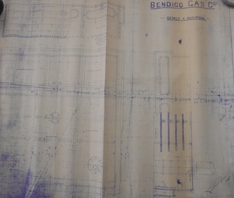 Bendigo Historical Society Inc.
Map - BENDIGO WEEROONA GASWORKS MAP/PLAN COLLECTION: DETAILS FOUR PURIFIERS, 1889
Plan/map: Bendigo Weeroona Gaswork, plan showing details four purifiers. Plan signed by? Thompson engineer, dated 1889. Written on bottom RH: this is one of the drawings referred to in my contract dated ... (undated).plan, bendigo, bendigo weeroona gas works, gasworks, thompson -
 Kew Historical Society Inc
Plan - Subdivision Plan, Windella-Darnley Subdivision, Studley Park, 1920s
Subdivision plans are historically important documents used as evidence of the growth of suburbs in Australia. They frequently provide information about when the land was sold on which a built structure was subsequently constructed as well as evidence relating to surveyors and real estate and financial agents. The numerous subdivision plans in the Kew Historical Society's collection represent working documents, ranging from the initial sketches made in planning a subdivision to printed plans on which auctioneers or agents listed the prices for which individual lots were sold. In a number of cases, the reverse of a subdivision plan in the collection includes a photograph of a house that was also for sale by the agent. These photographs provide significant heritage information relating house design and decoration, fencing and household gardens.Version 2 of two subdivision plans (the earlier is 2016.0305.1) for the section of Studley Park Road near the Junction on the south side. Named in the subdivision are the mansions of Darley and Windella (now demolished). Before the subdivision of Darley and Windella, both houses fronted Studley Park Road. Both houses appear to be advertised as lots in the subdivision. Bisecting the subdivision is a street, Antrim Avenue that was never constructed. A street, which was subsequently constructed in this vicinity, was Merrion Place, which now runs between Studley Park Road and Highfield Grove. There are 13 proposed lots in this subdivision in contrast to the earlier plan. This resulted from larger lots being proposed for Studley Park Road.subdivision plans - kew, studley park, windella, darnley, antrim avenue -- kew (vic.), studley park road -- kew (vic.), merrion place -- kew (vic.), merrion grove -- kew (vic.), highbury grove -- kew (vic.) -
 Federation University Historical Collection
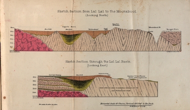
Booklet, Luplau, Hewood & Riderm Printers, The School of Mines Ballaarat Annual Report 1883, 1883
The School of Mines Ballaarat. Annual Report 1883. Statement of Receipts and expenditure, general balance sheet, and list of subscriptions donations 1882. Sketch of School of Mines. Sketch Section from Lal Lal to the Moorabool (looking north) Geological map of Lal Lal. In the County of Grant. Annual Report, Balance Sheet, Certificates granted by the Council, Examination Papers - Elementary Science Classes (Appendix), Extracts from Visitors' Book, Fees, Form of Bequest, Honorary Correspondents. Life Governors, Museum - open to visitors, Notes on the Geology of Lal Lal (with Geological Plan & Sections), Obituary, Office Bearers, Paper of Particulars, Rules of the Ballaarat Field Club and Science Society (Appendix), Report of the Curator of the Museum and Library, Report of the Superintendent of Laboratories, Report of the Lecturer in Mathematics, Report of the Lecturer in Mechanical Engineering, Report of the Lecturer in Telegraphy, Report of the Lecturer in Materia Medica, Statement of Receipts and Expenditure for the year 1882, Subjects and Lectures, Subjects and Examiners, Subscriptions and Donations, from 1st January to 31st December 1882.Ballaarat School of Mines annual Report. Hard cover red book of 101 pages. Includes plans on Lal Lal and surrounds. ballarat school of mines, annual report, balance sheet, certificates granted by the council, examination papers, extracts from the visitors' book, fees, form of bequest, honorary correspondents, life governors, museum, notes on the geology of lal lal, obituary: charles william thomas. one of the examiners in mining and surveying, office bearers, paper of particulars, rules of the ballaarat field club and science society, report of the curator of the museum and library, report of the superintendent of laboratories, report of the lecturer in mathematics, report of the lecturer in mechanical engineering, report of the lecturer in telegraphy, report of the lecturer in materia medica, statement of receipts and expenditure for the year 1882, subjects and lectures, subjects and examiners, subcriptions and donations, from 1st january to 31st december 1882, alf. mica smith, professor of chemistry, alf. mica smith, metallurgy, f. m. krause - professor of geology, mineralogy, scientific mining, t. h. thompson, practical mining, w. h. shaw mechanical engineering, h. reid, mechanical enginnering, phoenix foundry company (limited), a. a. buley, mathematics, f. m. krause, land, mining and engineering surveying, w. d. campbell, telegraphy, james oddie, vice-president, alf. mica smith, natural philosophy (elementary mechanics and hydrostatics, magnetism and electricty, sound, light and heat), j. f. usher, materia medica, pharmacy and physiology, examiner, professor h. m. andrew, m. a., examiner, h. d. de la poer wall, m. a, c. e., examiner, thomas mann, b. a., examiner, p. c. fitzpatrick, c. s., examiner, h. rosale, j.p., f.g.s, m.e. and m, examiner, john lewis, examiner, w. c. kernot, m.a., c.e., examiner, professor mccoy, examiner, j. cosmo newbery, c.m.g., b. sc., examiner, baron von mueller, k.c.m.g., m. et ph. d., f. r.s., examiner, sam. w. macgowan, examiner, w. p. bechervaise, examiner, r. l. j. ellery, f.r.s. govt. astronomer, examiner, f. m. krause, c.e., examiner, j. m. bickett, examiner, n. kent, examiner, a. martin, examiner, r. s. mitchell, examiner, w. h. keast, examiner, p. matthews, examiner, d. milliken, examiner, j. t. richards, examiner, jonathan robinson, examiner, t. h. thompson, examiner, h. brookes allen, m.d., examiner, joseph bosisto, examiner, c. r. blackett, m.l.a., examiner, wm. johnson, analyst to the government of victoria, ferdinand krause, ballarat field naturalists club, ferdinand von mueller, thomas mann, a.a. buley, ferrdinand krause, alfred mica smith, james oddie, william johnson, jonathan robinson, james bickett, r.l.j. ellery, cosmo newbery, ballarat field naturalists -
Ringwood and District Historical Society
Pamphlet, Ringwood Area pamphlets and promotional material. 2006, 2006
They include Maroondah Police Seniors Register, The Kerrabee Club Planned Activity Group, Skate and BMX in Maroondah, Access 4 all 2 Play, Local Service Groups, Carolyn Gold Bug display (Maroondah Gallery); and maintaining Mobility in Ringwood.Collection of 8 pamphlets about activities in Ringwood.; They include Maroondah Police Seniors Register, The Kerrabee Club Planned Activity Group, Skate and BMX in Maroondah, Access 4 all 2 Play, Local Service Groups, Carolyn Gold Bug display (Maroondah Gallery); and maintaining Mobility in Ringwood. -
 Bendigo Military Museum
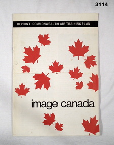
Booklet - BOOKLET, TRAINING, Reprint: Commonwealth Air Training Plan, c.1990
Soft cover booklet, white with red maple leaf images scattered over. Illustrated with black & white photos, four pages with a statistic card at end of the various air force involvement RCAF, RAF, RAAF, RNAT. 50th Anniversary of air training scheme.Black bar at top: Reprint: “Commonwealth Air Training Plan” Bottom: “Image Canada”training, booklet, canada -
 Melbourne Tram Museum
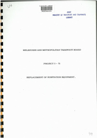
Document - Report, Melbourne & Metropolitan Tramways Board (MMTB), Project 3-75 - Replacement of Substation Equipment", 1975
Digital copy of a 9 page report by the MMTB, titled Project 3-75 - Replacement of Substation Equipment", proposing to replace the rotary converters installed between 1924 and 1930 with silicon rectifiers. Gives the locations, costs, schedule of replacement commencing 1975, in particular South Melbourne, Malvern and Young St Fitzroy. Gives a background to the system, a list of all the substations at the time, including date of installation, type, replacement of HV equipment, costs, reliability, maintenance costs, and benefit to cost ratio.Has the stamp of "Joint Ministry of transport and Tramways Library" and a "Plan & EPA Library barcode"trams, tramways, substation, transformer, power supply, electrical engineering, rotary converters -
 Kew Historical Society Inc
Map - Subdivision Plan, Grenville Estate, 1922
Pru Sanderson, in her groundbreaking ‘City of Kew Urban Conservation Study : Volume 2 - Development History’ (1988), summarised the periods of urban development and subdivisions of land in Kew. The periods that she identified included 1845-1880, 1880-1893, 1893-1921, 1921-1933, 1933-1943, and Post-War Development. These periods were selected as they represented periods of rapid growth or decline in urban development. An obvious starting point for Sanderson’s groupings involved population growth and the associated economic cycles. These cycles also highlighted urban expansion onto land that was predominantly rural, although in other cases it represented the decline and breakup of large estates. A number of the plans in the Kew Historical Society’s collection can also be found in other collections, such as those of the State Library of Victoria and the Boroondara Library Service. A number are however unique to the collection.Subdivision plans are historically important documents used as evidence of the growth of suburbs in Australia. They frequently provide information about when the land was sold on which a built structure was subsequently constructed as well as evidence relating to surveyors and real estate and financial agents. The numerous subdivision plans in the Kew Historical Society's collection represent working documents, ranging from the initial sketches made in planning a subdivision to printed plans on which auctioneers or agents listed the prices for which individual lots were sold. In a number of cases, the reverse of a subdivision plan in the collection includes a photograph of a house that was also for sale by the agent. These photographs provide significant heritage information relating house design and decoration, fencing and household gardens.In advertising the twenty-two sites of the Grenville Estate in Cotham Road and Alfred Street, Kew, the auctioneers emphasised the proximity of the development to shops, schools, and churches. That mansions surrounded the Estate was publicised as an added attraction. The plan shows how at this stage A regrettable aspect of this plan is that it is pasted over, and obscures a real estate photograph by the Kew photographer Josiah Earl Barnes.subdivision plans - kew, grenville estate, glenferrie road, alfred street, thomas street, cotham road -
 Bendigo Historical Society Inc.
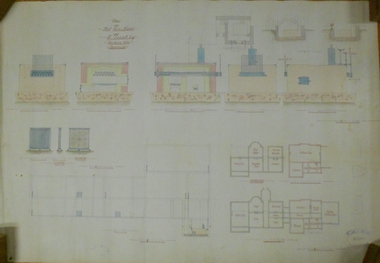
Document - MARKS COLLECTION: PLAN OF HOT WATER HEATER FORTUNA FOR G. LANSELL
Plan of hot water heater, Fortuna Villa, drawn on heavy paper. On top of plan in red ink 'Plan of Hot Water Heater for G. Lansell Esq for Fortuna Villa Sandhurst' Drawings show front, transverse, longitudinal, back and side elevations of heater, also back, side and front elevation of individual water heaters, including one with ornate screen. On bottom of document: floor plans of ground plan and basement. Plan stamped on RH bottom: William C. Vahland, Architect, Sandhurst.bendigo, house, fortuna villa -
 Bendigo Historical Society Inc.
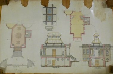
Plan - MARKS COLLECTION: SIDE AND FLOOR PLAN FORTUNA VILLA
Laminated plan, hand coloured, with side elevations and floor plans of Fortuna Villa entrance area. Basement, ceiling and first floor plans, with side elevations labelled Section A, B and (front view) Section C, D. On bottom of plan signed 'W. Beebe Architect' and 1/4' equals 1 foot.bendigo, buildings, fortuna villa -
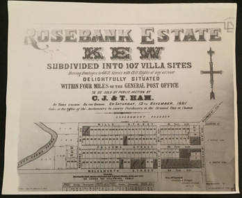 Kew Historical Society Inc
Plan - Subdivision Plan, Rosebank Estate, Kew
This work forms part of the collection assembled by the historian Dorothy Rogers, that was donated to the Kew Historical Society by her son John Rogers in 2015. The manuscripts, photographs, maps, and documents were sourced by her from both family and local collections or produced as references for her print publications. Many were directly used by Rogers in writing ‘Lovely Old Homes of Kew’ (1961) and 'A History of Kew' (1973), or the numerous articles on local history that she produced for suburban newspapers. Most of the photographs in the collection include detailed annotations in her hand. The Rogers Collection provides a comprehensive insight into the working habits of a historian in the 1960s and 1970s. Together it forms the largest privately-donated collection within the archives of the Kew Historical Society.Rosebank Estate (Kew). A photographic reproduction of a plan in the Vale Collection of the State Library of Victoria made for the historian Dorothy Rogers. This plan is a later version of the original subdivision plan after a number of lots had been sold.rosebank estate (kew), studley park, thomas ham, c.j. & t. ham, rosebank estate, kew, wills street, barry street, fellows street, redmond street, molesworth street, thomas wills, wills family