Showing 3069 items matching "scales"
-
 Federation University Historical Collection
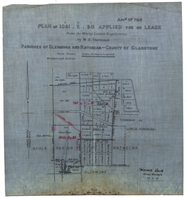
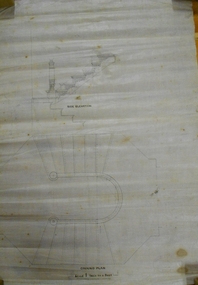
Plan, Plan applied for a Lease, Parishes of Glenmora and Rothcar, 27/05/1913
Plan on linen showing mining leases around the township of Lower Homebush, District of Maryborough. Scale: 20 chains to in inch (1:15840) WGS 84 Centroid Lat: 37 degrees 01 feet 35 inches S Long: 143 degrees 30 feet 35 inches S NS: 3.2km EW: 2.8km glenmona, rathcar, gladstone, maryborough, mining, clarence smith, homebush, clarence smith, w d thompson, peter leyden, b elliot, c horne, a field, john leydon, g jolly, r e jolly, d garner, s j barry, m harris, a harris, w j mcconnell, ellen harris, r j harris, j barry, t curtain, s garner, e barry, m j barry, l e squires, wilkins jnr, e c grace, e j field, mary field, m broughton, b l lusby, m j lusby, j e field, f broughton, j gillock, m simmons, glenmona, rathscar, parish of avoca, maryborough district, albert field, g grose, j harris -
 Federation University Historical Collection
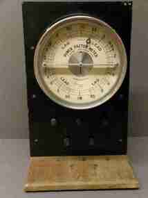
Scientific Instrument, Power Factor Meter
Item looks to have been adapted for bench top use Sindanyo high temperature insulation boards are manufactured from cement based products, reinforced with selected fibres. They have been specifically designed to provide excellent service under demanding thermal and electrical applications. Sindanyo is a non-asbestos, non-combustible product that is easily machined. This insulation board is a popular option when a high quality, strong and rigid material is required.400/500 Volt, 5 amp, 50 Hz 3-phase balanced load. Circular scale with lead and lag markings and graduations. The 22cm diameter meter rear-mounted to black sindanyo board, supported by wood brackets on wood base. Five terminal posts on panel below meter. Wire connections at rear. No maker's name Patent Number: 162471/20 Serial Number 263475scientific instruments, power factor maker, lead and lag markings, terminal posts, power factor meter, wire connections, sindanyo board, non-combustible, insulation, electrical applications -
 Bendigo Historical Society Inc.
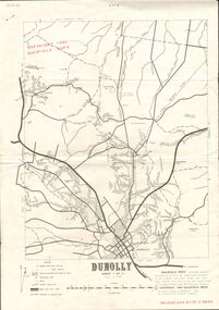
Document - JOAN O'SHEA COLLECTION: DUNNOLLY MAPS, 1980
Joan O'Shea Collection. Goldfield Maps Dunolly 3 Sheets 1980. Page 1: Mines in Dunolly, Whistling Flat, Painswick and Surrounds. Page 2: Mines in Goldsborough, McKinnons Gap, Bealiba Range, Stewarts Flat and Surrounds. Page 3: Mines in Dunolly, Emu Creek, Bet Bet, Bromley & Surrounds. Scale in Chains and Kilometres.GoldField Maps 1980 based on Dunolly 7624 by Division of National Mappinggold, goldfields, goldfield maps dunolly & surrounds -
 Bendigo Historical Society Inc.
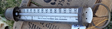
Tool - MERCURY THERMOMETER DOBBIE BROS
Mercury Thermometer (previously #95 from Mechanics Institute Eaglehawk). Mercury Fahrenheit Thermometer. Copper surrounds 'Made in England for DOBBIE Bros.' Melbourne. Approx 42cm long. Small Container surrounding mercury bulb at base. 'Freeze' written on the scale at 32 degrees. Maximum temperature 135 degrees. Minimum temp. 5 degreescottage, miners -
 Bendigo Historical Society Inc.
Map - CAMPBELL COLLECTION: BENDIGO AND DISTRICT MAPS
Map. Ascot, Parishes of Huntly, Sandhurst and Wellsford. Scale 20 chains to 1 inch. Total area 2818 acres. To Bendigo 4 1/2 miles, to Epsom 3/4 mile, Huntly 3/4 mile. Prepared in W.P.B. from Assessment Plans and Parish Plans. (number 380 in map cupboard 1)map, bendigo, agricultural lands -
 Bendigo Historical Society Inc.
Document - BILL ASHMAN COLLECTION: CORRESPONDENCE
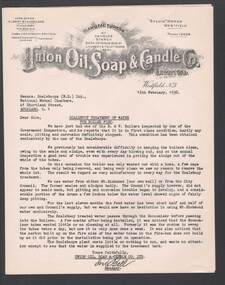
Four copies of a typed letter from ? Bell, Manager of the Union Oil, Soap & Candle Co. Ltd. To Scalebuoys (N. Z.) Ltd., dated 16 February, 1938. Letter refers to Scalebuoy treatment of water for boiler feed. Mentioned is how clean the boiler were of scale and sludge. Letter typed on paper with printed letterhead.sciences, instruments - general, scalebuoy, bill ashman collection - correspondence, union oil soap & candle co limited, scalebuoys (n.z.) ltd, ? bell -
Bendigo Historical Society Inc.
Map - CAMPBELL COLLECTION: BENDIGO AND DISTRICT MAPS, 1962
Map. Mandurang, County of Bendigo. Scale 40 chains to 1 inch. Sandhurst, Strathfieldsaye, Sedgwick, Sutton Grange, Ravenswood, Lockwood, Township of Kangaroo Flat, Township of Mandurang. By Authority A.C. Brooks, Government Printer, Melbourne. Drawn and Reproduced at the Department of Lands and Survey, Melbourne,1962, Price 2/-. (number 401 in map cupboard 1)A.C. Brooks, Government Printer.map, bendigo, allotments -
 The Ed Muirhead Physics Museum
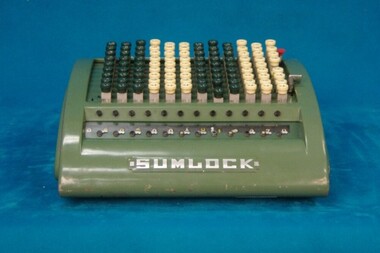
SUMLOCK Adding Machine
keys: 12 Plaque: ‘Supplied by Bell Punch A’sia Ltd / 160 Castlereagh St., Sydney / 27 Little Collins St., Melbourne / Agents and Services in all states / BPC / Cash Control Systems, Adding Machines, Ticket Registers, Charge Machines / Ticket Printers, Gum Tape, Scaling Machines etc. /’ good working condition -
 Bendigo Historical Society Inc.
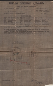
Document - JOAN LEVERSHA COLLECTION: BENDIGO SEWERAGE AUTHORITY PLAN HOUSE DRAINAGE
Bendigo Sewerage Authority plan of house drainage for Mr Douglas Dean, situation of property: weatherboard dwelling, 26 Bolt Street, Long Gully. Drainage plan no.35, Detail plan No. 134, retic. area No. long Gully. fee 7/6. Scale 40 feet to 1 inch. Dated 30/08/1954.organisation, government, bendigo sewerage authority -
 Bendigo Historical Society Inc.
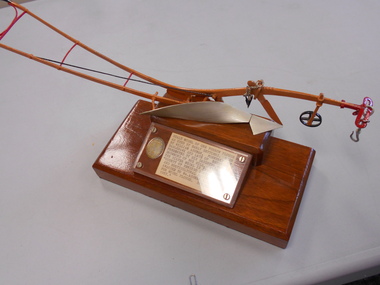
Award - THELMA DRUMMOND COLLECTION: SCALE MODEL ONE FURROW PLOUGH, 1887
Scale model of one furrow plough as used by early settlers. Made by William Ashman, formerly of Eaglehawk and late of Essendon. Presented by his daughter, Thelma Drummond of Box Hill, Victoria. The silver medal is inscribed "County of Bendigo Agricultural and Horticultural Societry. Awarded to Wm Ashman, Eaglehawk for model plough. Spring Show 1887".agriculture, farm, model plough -
 Bendigo Historical Society Inc.
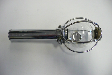
Tool - SCALEBUOY
Scalebuoy. Invented by Hartley Abbott & patented under the name of the Bendigo Electronic Company, made in various sizes & for different applications, such as to prevent scaling in the boilers at mines. Made up of a sealed glass bulb containing mercury and gasses enclosed within a chromed wire cage & with a chromed handle. The one shown being a hand held shaker model.sciences, instruments - general, scalebuoy -
 Bendigo Historical Society Inc.
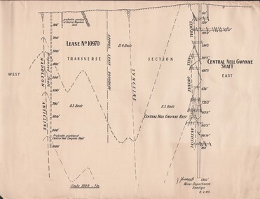
Document - MCCOLL, RANKIN AND STANISTREET COLLECTION: NAPOLEON REEF GOLD MINING CO. N.L, 1940
Document: 4 copies of plan of Transverse Section of Napoleon Anticline Lease no 10970, plan shows proposed shaft location and depth (1000 ft), for Napoleon Reef Gold Mining Co, also location and depth of adjacent Central Nell Gwynne Shaft scale 100ft = 1 inch, Prepared by J.J. Caldwell Mines Dept Bendigo.organization, business, industrial - mining, mccoll rankin & stanistreet, mining, gold mining, napoleon reef -
 Chiltern Athenaeum Trust
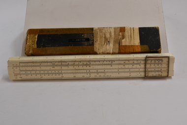
Slide Rule, Circa 1950
Slide rules were commonly used prior to the invention of the calculator. The Slide rule was used for performing multiplication, division and other scientific functions up through the 1960s and prior to the development of the electronic calculator. Used by Frank Smythe, engineer. Used up to the 1960's prior to the invention of the electronic calculator. Metal rule, hard cardboard case. The slide rule consists of two divided scales, one fixed and one movable, and a sliding window called a cursor. The Slide rule was used for performing multiplication, division and other scientific functions up through the 1960s and the development of the electronic calculator. System Darmstadt dmake, sun Hemm, Japan. "F. SMYTH" is annotated on the slide rule cover. slide rule, circa 1950 slide rule, trade measurements and calculations slide rule -
Ballarat Tramway Museum
Document - Photocopy, Phillip Adams, "Portrait of an artist scaling the heights", c1977
Photocopy - two A4 sheets of an article by Phillip Adams about artist Clifton Pugh, titled "Portrait of an artist scaling the heights", from a book "Unspeakable Adams: Forty Controversial and Popular Pieces", 1977. Looks at Pughs portrait work history with a tongue in cheek approach by the author about his portraits. Has a sketch by Spooner.trams, tramways, articles -
 Bendigo Historical Society Inc.
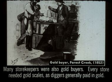
Slide - DIGGERS & MINING. STORES AT THE DIGGINGS, c1852
Diggers & Mining. Stores at the diggings. STG. Gold buyer, Forest Creek, (1852). Many store keepers were also gold buyers. Every store needed gold scales, as diggers generally paid in gold. Slide shows store keeper weighing the gold for the miners. Markings: 22 994.LIF. 5. Used as a teaching aid.hanimounteducation, tertiary, goldfields -
University of Melbourne, Burnley Campus Archives
Map, Melbourne Metropolitan Planning Scheme, c. 1978
Maps showing Zones and Reservations in the Merri Creek area of Melbourne, prepared by the Drafting Department, Planning Branch, MMBW. (1) Map No 36, coloured. (2) Map No 37, coloured. (3) Map No 38, not coloured. (4) Map No 46. Scale 1:9600. May have been used in planning the Native Garden Woodland Area. merri creek, melbourne and metropolitan board of works, melbourne metropolitan area -
![Map, Plan of Town Allotments Bacchus Marsh [1873]](/media/collectors/5e461d8021ea67224c82f2a1/items/677a8ee7ab7bb47995c5573f/item-media/677a8fdeab7bb47995c55b56/item-fit-380x285.jpg) Bacchus Marsh & District Historical Society
Bacchus Marsh & District Historical SocietyMap, Plan of Town Allotments Bacchus Marsh [1873]
James Young was a prominent businessman, land owner and public figure in the early colonial period of Bacchus Marsh. After his death in 1871 land remaining from his estate in Bacchus Marsh was sold at auction in 1873. The sale of his estate included the substantial stone residence in Bennett Street which later became known as 'Stone Villa'. The sale of his land in 1873 was conducted by local auctioneer James Crook. 29 allotments were advertised for sale, although the plan for the sale indicated 30 allotments. The sale notice in the Bacchus Marsh Express of 11 October 1873 noted that the allotments were " in the very centre and heart of the most populous and business portion of the township, at the same time being the only remaining portion of the business block available for purchase by public sale, which fact intending purchasers should not lose sight of, as the opportunity cannot occur again". The designation of a new street, 'Bennett Street', shown on the plan, is also indicated in the advertising, "In reference to the main street frontages, opposite the Border Flour Mills. The Auctioneer would also direct attention to the plan, showing the formation of a new thorough fare (Bennett street) leading from Young street into Gell street, thus opening up the township on the high, more healthy, and commanding position so much to be desired for private dwellings".An important cartographic document which indicates an early major subdivision of land in the inner urban area of the Bacchus Marsh township. This subdivision lead to the continuing residential and commercial development of the township of Bacchus Marsh in the later part of the 19th century. The location of two well known demolished public structures, the Free Gardeners Hall in Gell Street, and the Old Mechanics Institute Hall (aka the Buffs Hall), on the corner of Young and Bennett Streets, are also shown on this map.A single page paper map showing 30 blocks of land for sale around 1873 in the vicinity of Bennett Street and Lerderderg Street. Described in contemorary sources as a 'lithographed copy'. No scale is indicated. The map is pasted into a bound volume containing 76 maps or plans in total. High resolution digital image stored on BMDHS computer network. land sales bacchus marsh, bacchus marsh victoria maps, james young 1816-1871, bacchus marsh roads and streets, bennett street bacchus marsh -
Port Melbourne Historical & Preservation Society
Photograph - Aerial view of Port Melbourne, 23 Dec 1945
One of three prints of aerial photographs of Port Melbourne 23.12.1945, showing different areas and to different scales: this one vertical, takes in Station and Town Piers, railyards, Missions to Seamen, Engine Works, temporary US wartime structures, edge of COR buildings, Swallow & Ariell, portion of Wiilliamstown Road. (Smaller copies located in A.06.04.B4)piers and wharves - station pier, piers and wharves - town pier, war - world war ii, built environment, transport - railways, missions to seamen, swallow & ariell ltd -
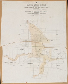 Bacchus Marsh & District Historical Society
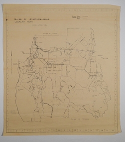
Map, Bacchus Marsh District (A). Proposed Irrigation and Water Supply Trust. Plan shewing boundaries of Trust District
The 1886 Irrigation Act in Victoria introduced the first legislation in Australia designed to enable the creation of a detailed scheme for agricultural irrigation. Part of the legislation saw the use of government funds for local irrigation projects. These local projects were managed by local irrigation trusts. The Bacchus Marsh Irrigation and Water Supply Trust was formed in 1889. This map depicts the proposed area of the Trust.Printed paper map of the proposed Bacchus Marsh Irrigation and Water Supply district. Circa 1889. Plan showing boundaries of Trust District. The District lies within the Parishes of Korkuperrimul, Merrimu, Parwan and Gorrockburkchap in the Counties of Bourke and Grant. At the top of the map above its title is the letter 'A; in capital lettering. Scale: 40 Chains = 1 inch.irrigation, water supply, bacchus marsh irrigation and water supply trust -
University of Melbourne, Burnley Campus Archives
Map, Kororoit Creek Proposed ..... [words obscured], 1998
Composite photocopy so title partly obscured, by Thompson Berrill Landscape Design DWC No KC 13 Sheet 13 of 14 dated March 1998. Scale 1:200. Legend includes: Vegetation, Drainage and Flood Management Issues and Action, Water Quality, Stream System V? Issues, Primary Objectives (partially obscured).thompson berrill, landscape design, kororoit creek, water quality, vegetation -
Glenelg Shire Council Cultural Collection
Plan - Plans - Line Drawing Port of Portland Authority, n.d
Port of Portland AuthorityFront: '36' - black texta, top right corner 'Total length cradle 24, outside' - black pen -
 Bendigo Historical Society Inc.
Document - STATE RIVERS AND WATER SUPPLY COMMISSION : KIMBOLTON RECREATIONAL AREA SEWERAGE PLAN
State Rivers and Water Supply Commission. Eppalock Project. Plan document titled: Kimbolton Recreational Area Committee. Sewerage of 'C' Section club sites. Rising Mains. Number 101378A is in bottom right corner. Diagrams: Detail pipe inlet at Lagoons, Detail pipe outlet. Plan scale: 1 inch = 6 chns. state infrastructure, water supply, coliban system, eppalock -
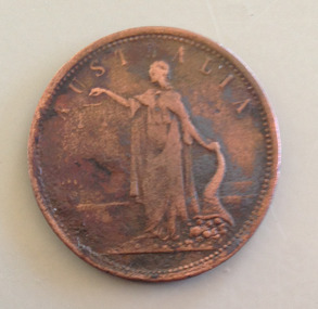 Warrnambool and District Historical Society Inc.
Coin - Token, Bateman & Co, 1855
This Bateman & Co penny token was given to Les O'Callaghan by his workmate and neighbour Roger Walsh. This is the story which accompanied the gift. 'This penny has been in my possession since 1946. Was obtained at Koroit Races that year -Royal Gem winner of the Caulfield Cup. This penny was wrapped in silver paper and was accepted by the bookmaker Mr Harold James whom I clerked for as a wager. I in turn payed [sic] my wages for working for this bookmaker and received same. Incidently [sic] the custom of this bookmaker in those days was the clerk usually was paid with silver, which was left in the bag as he did not wish to carry the silver home as he lived in Melbourne.Circular coin -obverse has name of company (William Bateman) in an inner circle with the word Victoria across the centre; within outer circle the type of trade engaged in and the year minted. The reverse has a female figure in flowing gown holding scales in the right hand and cornucopia in the left; the value of the coin is stamped around the top edge.WILLIAM BATEMAN WARRNAMBOOL/IMPORTERS AND GENERAL MERCHANTS 1855/VICTORIA (obverse) ONE PENNY (reverse)william bateman, les o'callaghan, penny tokens, horseracing, roger walsh, bookmakers, harold james -
 Melbourne Tram Museum
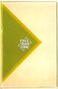
Sign, "Free Tram Zone", Late 2014
Sign - Free Tram Zone logo and background colours printed on a sheet of 5mm clear Perspex. Adam Chandler advised 15/11/2019 - These were prototypes in the office - from memory this was to evaluate the effectiveness of the treatment to tram stop shelter glass (at a much reduced scale)." Unknown sign manufacture - produced for the PTV late 2014.trams, tramways, free tram, signs, shelters, public transport -
 Bendigo Historical Society Inc.
Document - MARKS COLLECTION: SIDE ELEVATION AND GROUND PLAN OF STAIRWAY
Plan drawn on waxed paper. On top 'Side elevation' written in black ink, shows bottom treads of staircase, ornate bottom post of balustrade. On bottom of plan 'Ground Plan' written in black pen, 'Scale 1 Inch to a Foot' Plan contained in Fortuna Villa, George Lansell documents, although Fortuna Villa not written on plan.bendigo, house, fortuna villa -
 Bendigo Historical Society Inc.
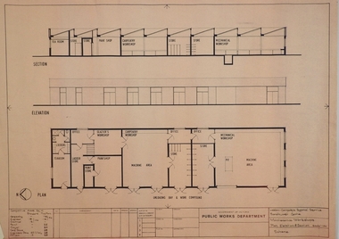
Plan - SANDHURST BOYS CENTRE COLLECTION: PLAN OF MAINTENANCE WORKSHOPS
Victoria Public Works Department. Sandhurst Boys Centre. Maintenance workshops plan, elevation & section, Scale 1:100. Elevation includes tea room, lockers bathroom; ladder store; glaziers workshop; paint shop & paint store; carpentry workshop; machine area; offices, store rooms; mechanical workshop. Location unknown 16.02.2023.bendigo, institutions, sandhurst boys centre, sandhurst boys centre site plans; maintenance workshops; loddon-campaspe regional service; victoria public works department -
 Bendigo Historical Society Inc.
Map - CAMPBELL COLLECTION: BENDIGO AND DISTRICT MAPS, 21-8-1972
Map. Shire of Strathfieldsaye, Locality Plan. Scale I inch=1 mile. Shire of Huntly, Shire of McIvor, City of Bendigo, Shire of Marong, Shire of Maldon, Shire of Metcalfe. Lake Eppalock. Mileage markers on some roads. Melbourne to Bendigo Railway Line, Big Hill Tunnel, Mt.Herbert 1596.Axedale Township, Strathfieldsaye Township.M.Higgs 21-8-1972map, bendigo, locality plan -
 Bendigo Military Museum
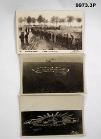
Postcard - PHOTOGRAPHIC POSTCARDS WW1
Two postcard signs likely taken on Salisbury Plains in UK. Other photo is of NZ Troops lined up in France for meals. Photo taken by Daily Mail as Official War Photo.1P. Black and white photo of troops lined up in France for meals. Postcard format on back. 2P. Photo of image of map of Australia and the word "Australia" inside on a plain in the UK, most likely Salisbury. 3P. Photo of large scale image of the Australian Rising Sun Emblem laid out on a plain. Assumed to be Salisbury Plain.No writing on postcards.selby collection, photographic postcards -
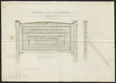 University of Melbourne, Burnley Campus Archives
Plan, Proposed Sign for Entrance to Burnley, 1931
(1) Correspondence between Mr Zevan (Government Cool Stores), the Agricultural Superintendent, R. Crowe (Exports Superintendent) and A.W. Jessep re design for new entrance gates at Burnley Gardens, between 31.03.1931 and 09.07.1931. Invoice from signwriter (A. Clegg). (2) Pencil sketch of proposed design with annotations. (3) Coloured drawing to scale.On verso of drawing: "Gate sign & Watering plans" and "File State Public Works"a.w. jessep, burnley gardens, f. zeven, signs, victoria. department of agriculture -
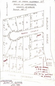 Ringwood and District Historical Society
Map, Subdivision Plan - Adam Court area, North Ringwood, Vic. - circa 1960s
Single page plan printed showing allotments included in un-named subdivision layout surrounding Adam Court, Ringwood North. Subdivision includes Adam Court, Burlock Avenue, and Felix Crescent. Sold allotmenets marked in red, with price notations.Page heading - Part of Crown Allotment 27B Parish of Warrandyte County of Evelyn Scale 60'-1". Rubber stamp imprint and handwritten address at bottom of page - "Binburra Estates Pty. Ltd. 23 Pitt St., Ringwood, 870-1184".