Showing 1306 items
matching shire of nillumbik
-
 Eltham District Historical Society Inc
Photograph - Digital Photograph, Alan King, Wycliffe Centre, Graham Road, Kangaroo Ground, 2008
... and people within the Shire of Nillumbik, an urban and rural ...Wycliffe translates the Bible for people around the world. Published: Nillumbik Now and Then / Marguerite Marshall 2008; photographs Alan King with Marguerite Marshall.; p171 The peace and beauty of Australia’s Wycliffe Centre reflects what it aims to bring to thousands of people around the world. Kangaroos calmly feed, accompanied by bird song, near the mud-brick buildings set amongst Kangaroo Ground’s rolling hills. On 11 hectares off Graham Road, the centre aims to transform people’s lives by giving groups around the world, with no written language, help with literacy and Bible translation into their own tongue. Associate Director, Harley Beck, says reading the Bible (probably history’s most influential collection of books), in one’s own language, provides a strong moral basis, helping people withstand exploitation and escape poverty. One of Wycliffe’s field partners, SIL (formerly Summer Institute of Linguistics) Papua New Guinea, has won two UNESCO awards, and SIL branches in many other countries have won international and national awards. The translators are modern heroes. They undertake hardships, forsaking for years, sometimes decades, a salary and the soft western lifestyle, to face loneliness and primitive conditions that most of us would not even contemplate. No staff is paid a salary. An example is the first Australian Director and former International President, David Cummings, who for 50 years has depended on donations from supporters and churches. Students of all ages at the EQUIP Training School on the site come from all walks of life. They train in linguistics and learn how to communicate in a way that is sensitive to other cultures. Spiritual resilience is encouraged, enabling people to persist until the job in the field is done, which takes on average ten to 15 years. Courses range from a few weeks to a year. The Wycliffe concept was born in the 1920s when American missionary, Cameron Townsend, found a Spanish Bible was inadequate to evangelise the Cakchiquel people of Guatemala. When a Cakchiquel man challenged: ‘If your God is so great, why doesn’t he speak my language?’ Townsend decided to translate the Bible into all languages! He founded a linguistics training school in 1934, naming it after 14th century theologian John Wycliffe, the first to translate the Bible into English. The first Wycliffe Bible was completed in 1951 in the Mexican San Miguel Mixtec language. In May 2007 after 30 years of work, Wycliffe Australia, with other organisations, completed the first Bible for indigenous people in the Kriol* language, for about 30,000 people in northern Australia. Wycliffe Australia began in 1954 in the Keswick Bookshop basement, Collins Street, Melbourne. As the organisation grew, its quarters became so cramped that Director Cummings at times interviewed potential recruits in his car! The development of the Kangaroo Ground property is a story of faith and generosity. In 1967 Cummings proposed moving to a larger property despite having no funds. Within a month Wycliffe received a $20,000 donation and a gift of land towards a national centre. An earlier owner of the Kangaroo Ground property, Mrs Elsie Graham, would have been delighted, as she had wanted her land to be used for ‘God’s service’. Mud-brick architect and Christian, Alistair Knox, offered to design the centre at no charge. Despite a drought, straw was donated to make bricks. Many volunteers helped with the building, including church youth groups who made mud-bricks. Volunteers planted thousands of native plants, watered by recycled water from the site’s dam. Building began in 1968 and in 1983 the South Pacific SIL School (now EQUIP Training) followed. Wycliffe, the world’s largest linguistic organisation, and other organisations, have translated the Scriptures into more than 2000 languages. But another 2000 languages still lack any portion of the Bible. However translations are now completed more quickly, because of new computer programs and as education spreads, more speakers of the local language can assist. Despite the growth of secularisation, Beck says support for Wycliffe Australia, which has offices in all states and the ACT, is stronger than ever. * Kriol is a Pidgin language, which has become a speech community’s prime language.This collection of almost 130 photos about places and people within the Shire of Nillumbik, an urban and rural municipality in Melbourne's north, contributes to an understanding of the history of the Shire. Published in 2008 immediately prior to the Black Saturday bushfires of February 7, 2009, it documents sites that were impacted, and in some cases destroyed by the fires. It includes photographs taken especially for the publication, creating a unique time capsule representing the Shire in the early 21st century. It remains the most recent comprehenesive publication devoted to the Shire's history connecting local residents to the past. nillumbik now and then (marshall-king) collection, graham road, kangaroo ground, wycliffe centre -
 Eltham District Historical Society Inc
Photograph - Digital Photograph, Marguerite Marshall, Jesse Tree playing the Didgeridoo and Swiss Hang Drum at St Andrews Market, 29 March 2008
... the Shire of Nillumbik, an urban and rural municipality ...Published: Nillumbik Now and Then / Marguerite Marshall 2008; photographs Alan King with Marguerite Marshall.; p175 It’s Saturday morning and thousands of people are visiting St Andrews Market at the corner of Heidelberg-Kinglake Road and Proctor Street. It’s hard to find a park. Cars are banked up along the narrow road and crammed in a nearby parking area. Yet, at the market, people look relaxed and happy amongst the yellow box gums on the site where the Wurundjeri people used to gather. Stone artefacts unearthed there by Koorie researcher, Isabel Ellender, indicate the site was once a Wurundjeri meeting place, according to Aboriginal Affairs Victoria. Acoustic sounds mingle with quiet conversations. A guitarist blows a mouth organ while his bare toes tickle chimes. A tiny busker, perhaps five years old, plays a violin while sounds of a harp emerge from the hall. One stallholder, selling delicious-looking pastries, chats to another in Spanish, then to me in broad Australian. ‘I was born in Fitzroy but my mother came from Mexico and my dad from Serbia,’ she smiles. A New Zealander fell in love with Mongolia and now imports their hand-made embroidered clothes and Yurts (tents) and runs adventure tours. A young woman visited Morocco and when friends admired the shoes she bought, she decided to import them and sell them at the market. Oxfam sells Fair Trade toys and clothes and displays a petition to Make Poverty History. Other stalls sell Himalayan salt, jewellery made from seeds from northern Australia, glass paper-weights from China as well as locally grown vegetables, flowers and organic freshly baked bread. A woman sits in a state of bliss under the hands of a masseur. Another offers Reiki or spiritual healing. A juggler tosses devil sticks – ‘not really about the devil,’ he smiles. This skill was practised thousands of years ago in Egypt and South America he says. At the Chai Tent people lounge on cushions in leisurely conversation. The idea for the market was first mooted among friends over a meal at the home of famous jazz and gospel singer Judy Jacques.2 Jacques remembers a discussion with several local artists including Marlene Pugh, Eric Beach, Les Kossatz, Ray Newell and Peter Wallace. ‘We decided we wanted a meeting place, where all the different factions of locals could meet on common ground, sell their goodies and get to know one another,’ Jacques recalls. They chose the site opposite another meeting place, St Andrews Pub. A week later Jacques rode her horse around the district and encouraged her neighbours to come along to the site to buy or sell. On February 23, 1973, about 20 stallholders arrived with tables. They traded ‘second-hand clothes, vegetables, meat, cheese, eggs, chickens, goats, scones, tea, garden pots and peacock feathers’. Now around 2000 people visit each Saturday. People usually linger until dusk. The market – with around 150 stalls of wares from a wide variety of cultures – stands alongside Montsalvat as the most popular tourist attraction in Nillumbik. By the 1990s St Andrews Market was in danger of being loved to death, as the site was becoming seriously degraded. The market was spreading in all directions and the degradation with it. A local council arborist’s report in 1994 noted exposed tree roots from erosion and compaction. The Department of Sustainability and Environment threatened to close the market if the degradation was not rectified. After many months of research, discussions and lobbying by a few residents, the council formed a Committee of Management, with an Advisory Committee, and introduced an Environment Levy. The State Government, the council and the market, funded terracing of the site to stop erosion, and retain moisture and nutrients. Vehicles were excluded from some sensitive areas and other crucial zones reserved for re-vegetation. Volunteers planted more than 3000 locally grown indigenous species. The old Yellow Box trees fully recovered and are expected to give shade for many years to come.This collection of almost 130 photos about places and people within the Shire of Nillumbik, an urban and rural municipality in Melbourne's north, contributes to an understanding of the history of the Shire. Published in 2008 immediately prior to the Black Saturday bushfires of February 7, 2009, it documents sites that were impacted, and in some cases destroyed by the fires. It includes photographs taken especially for the publication, creating a unique time capsule representing the Shire in the early 21st century. It remains the most recent comprehenesive publication devoted to the Shire's history connecting local residents to the past. nillumbik now and then (marshall-king) collection, didgeridoo, jesse tree, st andrews market, swiss hang drum -
 Eltham District Historical Society Inc
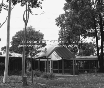
Photograph - Digital Photograph, Alan King, Alistair Knox Park, Eltham, 2008
... to the Shire's history connecting local residents to the past. Nillumbik ...Alistair Knox Park, an oasis of peace and beauty. Covered under National Trust of Australia (Victoria) Landscape Significance and Heritage Overlay, Nillumbik Planning Scheme. Published: Nillumbik Now and Then / Marguerite Marshall 2008; photographs Alan King with Marguerite Marshall.; p173 It is hard to imagine that the Alistair Knox Park, an oasis of peace and beauty beside busy Main Road, Eltham, was once the township’s rubbish dump. It was only in the 1970s that the tip was transformed into this beautiful six hectare space, which later earned it a National Trust Landscape classification. Before its life as a dump, the area was used for small farms. Thanks largely to the foresight and efforts of local environmental builder Alistair Knox, the park was designed sympathetically with the character of the wider Eltham landscape. Then, appropriately, the park was named after Knox, who was an Eltham Shire Councillor from 1971 to 1975 and Shire President in 1975. The park designers were four major forces in the urban bush landscape garden –Knox, landscape designer Gordon Ford, artist Peter Glass and landscaper Ivan Stranger. The National Trust citation for the park, originally called Eltham Town Park, includes the Eltham railway trestle bridge and the Shillinglaw Cottage. The citation states ‘the semi-natural setting of the parkland provides a landscape which is evocative of the history of the area’. Manna Gums (Eucalyptus viminalis) and Candlebarks (Eucalyptus rubida) are significant features. Most of the park’s construction was directed by Bob Grant, Superintendent of the Parks and Gardens Department for the Eltham Shire Council. First plantings occurred in Arbour Week in 1973, then the lake and botanic area were completed in 1975, with Federal Government funding, and the toilet block in 1978. Bounded by the Eltham railway line, Panther Place, Main Road, Bridge and Susan Streets, the park is in a valley about a kilometre wide overlooked by steep hills at the east and west. The Diamond Creek flows through it and the picturesque historic timber trestle railway bridge edges the north. Informal plantings of Australian indigenous and native species in open and undulating grassed settings blend with the natural landscape of the Diamond Creek to the west. The bush-style plants, particularly around the creek, balance with open lawns, paths and a cascade flowing from a small lake to another below. A footbridge over the creek leads to the park’s west. The park includes an adventure playground and barbecue areas. The park stands on part of the land bought from the Crown in 1851 by Josiah Holloway, who subdivided it into allotments and which he called Little Eltham. Most of the land was subdivided into residential lots, but the creek valley, on which the park stands, was subdivided into farm-size lots, used mainly for orchards and grazing. One of the earliest owners was John Hicks Petty, who in 1874 bought a plot from Holloway. Other families who owned properties in that area, included Rees, Clark, Waterfall, Graham, Hill and Morant. In 1901 the railway was built through the area. Jock Read, an Eltham resident since around 1920, remembers several farms in the 1920s and ’30s that occupied the site of today’s park. A poultry farm, which extended from present day Panther Place, was owned by the Gahan family. Next to that farm was another for grazing cattle owned by Jack Carrucan. Beside this was land owned by John Lyon. A doctor lived beside this, and at the north-west corner of Bridge Street and Main Road stood a memorial to the soldiers who died in World War One, which was later moved to the RSL site. Mr Read also remembers other farms and orchards west of the creek In the early 1960s the Eltham Council began buying these farms and in the late 1960s turned the areas east of the Diamond Creek into a garbage tip. When this was filled above the creek’s flood plain, the tip was moved to the west of the creek.This collection of almost 130 photos about places and people within the Shire of Nillumbik, an urban and rural municipality in Melbourne's north, contributes to an understanding of the history of the Shire. Published in 2008 immediately prior to the Black Saturday bushfires of February 7, 2009, it documents sites that were impacted, and in some cases destroyed by the fires. It includes photographs taken especially for the publication, creating a unique time capsule representing the Shire in the early 21st century. It remains the most recent comprehenesive publication devoted to the Shire's history connecting local residents to the past. nillumbik now and then (marshall-king) collection, alistair knox park, eltham -
 Eltham District Historical Society Inc
Photograph - Digital Photograph, Alan King, Diamond Creek, Barak Bushlands, Eltham, 2008
... and people within the Shire of Nillumbik, an urban and rural ...A habitat corridor and it strengthens the community. Published: Nillumbik Now and Then / Marguerite Marshall 2008; photographs Alan King with Marguerite Marshall.; p185 Barak Bushlands lie west of the Diamond Creek on the corner of Falkiner Street and busy, noisy Main Road. They form part of an important habitat corridor linking the Yarra River to the Kinglake National Park.1 Manna Gums, tawny frogmouths and platypuses are some of the indigenous plants and animals that have made their home there. The bushlands are the result of more than nine years of hard work by the local community with the Nillumbik Council, to transform a degraded flood plain into this refuge of natural beauty. In 1997, shortly after moving into the new Riverside Estate on Falkiner Street, Eltham, several residents noticed the sorry state of the Diamond Creek and surrounding area. Part of it was used as a cow paddock and although small patches of vegetation survived, the area was infested with weeds, rabbits, rubbish and drainage from the housing estate. At various times the 4.4 hectares had been used as a market garden and for shire stock piles. The residents began to restore the area by revegetating land along the Diamond Creek. In 1998 they established the Friends of the Diamond Creek Falkiner Street Reserve2 and 35 families joined from the 90-house Estate. Carolyn Mellor, as the Friends’ Land Manager, undertook a four-year horticulture course to guide this massive project for a volunteer organisation. Since 1999, she has been the Friends’ President. In 1999 the Friends urged the Nillumbik Council to undertake a feasibility study into establishing a wetland system and urban forest. Work began in 2002 with Nillumbik Council funding the project, supplemented by government grants. The Friends also received grants from Melbourne Water and Parks Victoria. Aided by the Friends and other community members, the Council created the Barak Bushlands consisting of a forest, a wetland, a bridge, a path and open space. The beautiful wetland treats most of the estate’s stormwater runoff. Storm water is filtered through plants in the wetland ponds then is released slowly into the billabong, before flowing into the Diamond Creek. The wetland also helps to minimise flooding and the improved water quality provides a flora and fauna habitat. The Friends and other volunteers planted more than 27,000 plants, more than one third of which they grew from seeds they collected at Lower Eltham and Wingrove Parks. Eltham High School students planted thousands of these through a Year Eight program introduced for this purpose. Other groups who assisted were: Green Corps, local Scouts and Guides – 2nd Montmorency, 1st Diamond Creek and 1st Eltham Cub Packs, Eltham College students, Eltham East Primary School, Landcare members, Eltham Lions Club and the Eltham Baptist Church. To maintain enthusiasm for the mammoth task, the Friends and other volunteers ‘adopted’ trees to water and wrote their names on the stakes. In 2004, to recognise the area’s original occupiers, the reserve was named Barak Bushlands. William Barak, who lived from 1824 to 1903, was the last chief of the Yarra Yarra tribe of the Wurundjeri-willam people. Traces of these original inhabitants remain in scar trees (bark sections removed to make a shield or canoe). That same year the Friends’ group was a finalist in the prestigious Federal Government, Banksia Environmental Awards. The Friends have also participated in Clean Up Australia, removing tonnes of rubbish and regularly testing the billabong, wetland and creek, for pollutants. For years the Friends, together with the Australian Platypus Conservancy, have tagged, measured and checked the health of platypuses from the Diamond and Mullum Mullum Creeks. With Latrobe University the Friends have conducted night walks to view owls, possums, bats and sugar gliders. Challenges for the council and the Friends continue with a large rabbit population, some vandalism, weed eradication and maintenance. However, thanks to this community effort, locals can now escape confined urban living on small blocks of land and enjoy the beauty of indigenous plants and animals. Working together has also strengthened the local community,This collection of almost 130 photos about places and people within the Shire of Nillumbik, an urban and rural municipality in Melbourne's north, contributes to an understanding of the history of the Shire. Published in 2008 immediately prior to the Black Saturday bushfires of February 7, 2009, it documents sites that were impacted, and in some cases destroyed by the fires. It includes photographs taken especially for the publication, creating a unique time capsule representing the Shire in the early 21st century. It remains the most recent comprehenesive publication devoted to the Shire's history connecting local residents to the past. nillumbik now and then (marshall-king) collection, barak bushlands, diamond creek (creek), eltham -
 Eltham District Historical Society Inc
Photograph - Digital Photograph, Alan King, Sign: Clara Southern, Heidelberg School Artists Trail, Main Road, Research, 2008
... to the Shire's history connecting local residents to the past. Nillumbik ...Warrandyte artist, Clara Southern, features on the Artists Trail. Published: Nillumbik Now and Then / Marguerite Marshall 2008; photographs Alan King with Marguerite Marshall.; p189 Since early in the 20th century this district has attracted artists and other creative people. So much so, that Eltham has been compared to the Left Bank in Paris, New York’s Greenwich Village and London’s Bloomsbury. That is until the 1970s when Eltham rapidly expanded into a suburb. However many artists still flourish not only in Montsalvat, Dunmoochin and the Bend of Islands but elsewhere in Nillumbik. Some artists who have worked or lived in Nillumbik are well-known nationally and internationally. Artists are attracted to the hilly district’s subtle colours, unique light and the Yarra River and Diamond Creek. The railway’s extension to Eltham in 1902 brought artists to paint for the day or to camp. Then many settled in Eltham, perhaps also because the poor quality land, far from the city, was cheap. Following World War Two they found they could build houses and studios cheaply by making their own mud-bricks. The flexible material, with its warm tones blending into the bush, also satisfied their aesthetic sensibilities. As early as 1900, Will Longstaff, known for his painting The Ghosts of Menin Gate at the National War Memorial in Canberra, lived at Stanhope in Peter Street, Eltham, later to become the home of intellectuals Clem and Nina Christensen. Members of Australia’s first significant art movement, the Heidelberg School of Artists, painted in Eltham, Warrandyte and Diamond Creek. Walter Withers lived at the corner of Bolton and Brougham Street, Eltham and taught Sir Hans Heysen, who for a short while stayed with the Withers family. In Warrandyte were Clara Southern, whom Frederick McCubbin taught at the National Gallery School and Penleigh Boyd, who is represented in all Australian state galleries and the National Collection in Canberra. May Vale, daughter of politician William, lived in Diamond Creek. With Jane Price they feature on the Heidelberg School Artists Trail, part of which runs through Nillumbik. The trail includes signs each displaying a reproduction of a painting by an artist and located near where the artist lived or painted. In Nillumbik the trail includes parts of Warrandyte, Eltham in the Alistair Knox Park, Main Road shopping precinct and Wingrove Park, the Research walking track on Main Road and the Diamond Creek Reserve. In 1916 artist William ‘Jock’ Frater lived at the corner of Arthur and Bible Streets, Eltham. Before then, Frater, with other artists including Percy Leason (who moved to Eltham in the mid 1920s) painted in Eltham on weekends. They camped near Bible and Pitt Streets and along the Diamond Creek where the Eltham Retirement Centre now stands.4 In 1921, painter Peter Newbury (father to painter David Newbury, who was born in Eltham) moved to Cromwell Street, Eltham. Max Meldrum, the first Australian painter to formulate a consistent theory of art largely based on tone,5 taught local artists Alan Martin, Clarice Beckett, Peter Glass and Justus Jörgensen. Meldrum visited Eltham then rented a house there for 18 months opposite Wingrove Park. In 1934, artist and architect Justus Jörgensen and his doctor wife Lil and friends built Montsalvat, the artists’ colony. Montsalvat has played an important part in attracting artists to Eltham and its mud-brick, pisé, stone and recycled building materials has had a major influence on Eltham’s built environment. Jörgensen’s students who also helped him build Monstalvat included Arthur Munday, Lesley Sinclair, Helen Lempriere, Joe Hannan, Helen, Sonia and jeweller/sculptor, Matcham Skipper. Among artists who visited Montsalvat were Clifton Pugh and Angry Penguins’ artists Albert Tucker and Arthur Boyd. Some who painted after World War Two were Alan Martin of Eltham and Warrandyte artists Frank Crozier and Harry De Hartog6, one of Melbourne’s first painters influenced by Cubism.This collection of almost 130 photos about places and people within the Shire of Nillumbik, an urban and rural municipality in Melbourne's north, contributes to an understanding of the history of the Shire. Published in 2008 immediately prior to the Black Saturday bushfires of February 7, 2009, it documents sites that were impacted, and in some cases destroyed by the fires. It includes photographs taken especially for the publication, creating a unique time capsule representing the Shire in the early 21st century. It remains the most recent comprehenesive publication devoted to the Shire's history connecting local residents to the past. nillumbik now and then (marshall-king) collection, clara southern, main road, research (vic), heidelberg school artists trail -
 Eltham District Historical Society Inc
Photograph - Digital Photograph, Marguerite Marshall, Eltham Retirement Centre (Judge Book Memorial Village), Diamond Street, Eltham, 23 October 2006
... to the Shire's history connecting local residents to the past. Nillumbik ...Thousands of elderly people at this centre have contributed much. Published: Nillumbik Now and Then / Marguerite Marshall 2008; photographs Alan King with Marguerite Marshall.; p161 Thousands of elderly people, who have contributed much to Nillumbik and beyond, have made their home in the treed Eltham Retirement Centre. The centre, which opened in 1956, has housed the disadvantaged in particular, through good times and hard, including floods, fire and even burglaries. As part of the Melbourne Citymission, a non-denominational Christian organisation that cares for people living with disadvantage, the centre was built to celebrate 100 years of the Melbourne Citymission’s work since 1854. Standing on a former poultry farm called Willandra (Still Waters), the centre includes independent units, hostel, nursing home accommodation and a Day Therapy Centre, which is available for non-residents as well. Despite being metres from the busy Main Road and railway station, the centre provides a quiet oasis on 6.8 hectares bordered by the Diamond Creek to the west, and the railway line to the east. The centre was originally named Judge Book Memorial Village after Judge Clifford Book, Deacon of the Collins Street Baptist Church. Book was also President of the Baptist Union of Victoria and Grand Master of the Masonic Lodge. He was so respected that, at his death, several Pentridge prisoners asked to attend his funeral. In 1993 the centre’s name was changed to clarify that it was part of the Melbourne Citymission. However Judge Book’s name continues in the Judge Book Memorial Garden, opened in 2006. The Diamond Creek has flooded the centre several times, however rarely causing serious damage. Volunteer Alan Field recalls a flood in 1974 when the resident manager Reverend Norman Pearce and his wife, were rescued by boat from their home with their budgerigar. On February 3, 2005, when the creek almost flooded Metzner Hall, 35 ambulances evacuated residents to nearby nursing homes, hostels and local homes. Residents were also evacuated during the 1965 bush fire, but fortunately a change of wind direction saved the centre. Residents have also endured several burglaries. Despite much rebuilding and modernisation over the years, traces of the original farmhouse remain in the administration areas. In 1991 the Willandra Hostel was built and in 2001 the Eltham Lodge Nursing Home with each room having a garden view. Several buildings are named after people who have given special service to the centre including the Norman Pearce Day Hospital after general manager and pastor Rev Pearce. Metzner Hall was named after the Metzner family who had been active in the auxiliary since it began and had donated generously to the Recreation Hall fund.3 A bridge was named after Sister Lila Murray who had worked at the village for 42 years in various capacities including as relieving manager. Field remembers Sister Murray as ‘the Mother Teresa and soul of what the village aspired to, with love and care’. Since 1957 the Eltham Auxiliary, later called the Residents’ Association, has worked to improve the residents’ quality of life by volunteering and raising funds. An outstanding volunteer, Field, who was drawn to the centre in 1971 with his wife Chris, has held positions on the early Eltham boards, auxiliaries and Residents’ Association. Much of his work has been supporting people with no family and those of limited means. He says he and his wife look at their work as having shared ‘our lives with amazing people’. The wealth of experience and wisdom in the Retirement Village has benefited many people, including local school children. Residents have acted as proxy grand-parents at local schools, by assisting small learning groups or telling their life stories. Conversely, students from local schools have visited to perform, or to assist in programs like craft activities. Resident Val Bell, whose mother Rose Bullock lived at the centre before her, sums up the centre’s most important attribute for her: ‘The Christian care. They could not be more caring’.This collection of almost 130 photos about places and people within the Shire of Nillumbik, an urban and rural municipality in Melbourne's north, contributes to an understanding of the history of the Shire. Published in 2008 immediately prior to the Black Saturday bushfires of February 7, 2009, it documents sites that were impacted, and in some cases destroyed by the fires. It includes photographs taken especially for the publication, creating a unique time capsule representing the Shire in the early 21st century. It remains the most recent comprehenesive publication devoted to the Shire's history connecting local residents to the past. nillumbik now and then (marshall-king) collection, diamond street, eltham, eltham retirement centre, eltham retirement village, judge book memorial village -
 Eltham District Historical Society Inc
Journal - Newsletter, Newsletter, No. 280 February 2025
Contents: • 2024 was indeed a busy year by Jim Connor • Our next meeting –7:30pm Wednesday 12th February 2025 – Homeland: Stories from Afar; Liz Pidgeon YPRL • Our next excursion – Saturday 1st March 2025 – Nillumbik Historical Society • Convict Life On The Chain by Ian Bryant • Eltham Water Reserve • My Schooldays at Killeavey by Jenny Ellis • Margot Knox by Alistair Knox • Margot Knox 1931 - 2002 by Gwen Ford • Men’s Sheds by Jim Connor • Little Eltham Heritage Walk brochure • Early Eltham • Hurstbridge Rail Line Electrification by Richard Pinn The Shire of Eltham Historical Society was formed in October 1967. The first newsletter of the Society was issued May 1978 and has been published continuously ever since on a bi-monthly basis. With the cessation of the Shire of Eltham in late 1994, the Society's name was revised to Eltham District Historical Society and this name first appeared with issue No. 103, July 1995. The collection of the Society's newsletters provides a valuable resource on the history of the Society's activities, office bearers and committee members, guest speakers and subjects of historical interest pertinent to the former Shire of Eltham and the Eltham District.A4 newsletter distributed to members (Digital and A4 photocopy)newsletter, eltham district historical society -
 Greensborough Historical Society
Poster - Planning Document, Shire of Diamond Valley et al, Subdivision Plan # 1018 - Parish of Nillumbik, County Bourke, Crown Allotment 4 Section 15, and Crown Allotment B Section 12, Eltham North, 1981-1982
Subdivision Plan # 1018 - Parish of Nillumbik, County Bourke, Crown Allotment 4 Section 15, and Crown Allotment B Section 12, Eltham North. This subdivision plan includes Ryans Road (also known as Government Road) and St Clems Street. The developer for this subdivision is Taunton Developments and the Surveyors are Fisher Cleeland Turner & Dwyer Vic, Surveyors and Engineers.An example of hard copy subdivision plans from the Greensborough area. Mainly from the Shire of Diamond Valley era (1964-1994).Plan (single sided) mounted on heavy card. Stamped and handwritten Council permissions, dates and other details. subdivision plans, shire of diamond valley, taunton developments -
 Greensborough Historical Society
Poster - Planning Document, Shire of Diamond Valley et al, Subdivision Plan # 1026 - Parish of Nillumbik, County Bourke, Crown Allotment B Section 12, Eltham North, 1981-1984
Subdivision Plan # 1026 - Parish of Nillumbik, County Bourke, Crown Allotment B Section 12, Eltham North. This subdivision plan includes Ryans Road (also known as Government Road) and St Clems Street. The developer for this subdivision is Taunton Developments and the Surveyors are Fisher Cleeland Turner & Dwyer Vic, Surveyors and Engineers.An example of hard copy subdivision plans from the Greensborough area. Mainly from the Shire of Diamond Valley era (1964-1994).Plan (single sided) mounted on heavy card. Stamped and handwritten Council permissions, dates and other details. subdivision plans, shire of diamond valley, taunton developments -
 Greensborough Historical Society
Poster - Planning Document, Shire of Diamond Valley et al, Subdivision Plan # 1044 - Parish of Nillumbik, County Bourke, Crown Allotment B Section 12, Eltham North, 1981-1987
Subdivision Plan # 1044 - Parish of Nillumbik, County Bourke, Crown Allotment B Section 12, Eltham North. This subdivision plan includes Weidlich Road and St Clems Street. The developer for this subdivision is Taunton Developments and the Surveyors are Fisher Cleeland Turner & Dwyer Vic, Surveyors and Engineers.An example of hard copy subdivision plans from the Greensborough area. Mainly from the Shire of Diamond Valley era (1964-1994).Plan (single sided) mounted on heavy card. Stamped and handwritten Council permissions, dates and other details. subdivision plans, shire of diamond valley, taunton developments -
 Eltham District Historical Society Inc
Book, Richard E. G. Brown, Diamond Valley Conservation Strategy: Policy Report, 1995
... with the newly created Shire of Nillumbik, City of Banyule and City ...The Diamond Valley Conservation Strategy will be used by Nillumbik and Banyule councils when developing conservation policies. The strategy was developed by the former Shire of Diamond Valley and documents environment and heritage values and possible threats to those values of the former Shire and policy aims and objectives. This report documents flora and fauna conservation, heritage conservation, landscape conservation, sustainable land use, conservation of resources, waster management and community education and involvement. The Shire of Diamond Valley (1964-1994) was abolished in May 1994. Areas merged with the newly created Shire of Nillumbik, City of Banyule and City of Whittlesea.27 p.non-fictionThe Diamond Valley Conservation Strategy will be used by Nillumbik and Banyule councils when developing conservation policies. The strategy was developed by the former Shire of Diamond Valley and documents environment and heritage values and possible threats to those values of the former Shire and policy aims and objectives. This report documents flora and fauna conservation, heritage conservation, landscape conservation, sustainable land use, conservation of resources, waster management and community education and involvement. The Shire of Diamond Valley (1964-1994) was abolished in May 1994. Areas merged with the newly created Shire of Nillumbik, City of Banyule and City of Whittlesea.environmental policy, environmental protection, shire of diamond valley -
 Eltham District Historical Society Inc
Book, Richard E. G. Brown, Diamond Valley Conservation Strategy, 1995
... . Areas merged with the newly created Shire of Nillumbik, City ...The Diamond Valley Conservation Strategy, compiled by Rik Brown, Conservation Officer, Banyule City Council will be used by Nillumbik and Banyule councils when developing conservation policies. The strategy was developed by the former Shire of Diamond Valley and documents environment and heritage values and possible threats to those values of the former Shire and policy aims and objectives. The Shire of Diamond Valley (1964-1994) was abolished in May 1994. Areas merged with the newly created Shire of Nillumbik, City of Banyule and City of Whittlesea.non-fictionThe Diamond Valley Conservation Strategy, compiled by Rik Brown, Conservation Officer, Banyule City Council will be used by Nillumbik and Banyule councils when developing conservation policies. The strategy was developed by the former Shire of Diamond Valley and documents environment and heritage values and possible threats to those values of the former Shire and policy aims and objectives. The Shire of Diamond Valley (1964-1994) was abolished in May 1994. Areas merged with the newly created Shire of Nillumbik, City of Banyule and City of Whittlesea.shire of diamond valley, conservation, environmental policy, strategy -
 Eltham District Historical Society Inc
Article, Natalie Town, Councils agree to conservation plan, 6 December 1995
Newspaper article about the new Diamond Valley Conservation Strategy which will be used by Nillumbik and Banyule councils when developing conservation policies. The strategy was developed by the former Shire of Diamond Valley and documents environment and heritage values and possible threats to those values of the former Shire and policy aims and objectives.non-fictionNewspaper article about the new Diamond Valley Conservation Strategy which will be used by Nillumbik and Banyule councils when developing conservation policies. The strategy was developed by the former Shire of Diamond Valley and documents environment and heritage values and possible threats to those values of the former Shire and policy aims and objectives.conservation, strategy -
 Greensborough Historical Society
Booklet, Celebrating Nillumbik women 2010, 2010_
... nillumbik shire council...Nillumbik Shire Council... the Nillumbik Women's Network and Nillumbik Shire Council. nillumbik ...Biographical details of prominent local Nillumbik womenDetails the achievements of local women. An annual award from the Nillumbik Women's Network and Nillumbik Shire Council.Colour cover with photographs of Nillumbik women. 24 p., illus. nillumbik shire council, nillumbik womens network, eltham women, diamond valley women -
 Eltham District Historical Society Inc
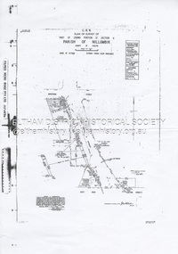
Document - Survey Plan, Country Roads Board et al, SP 12272A, Eltham-Yarra Glen Road; Brougham St to Dalton St, 1970-1976
1970 C.R.B. Plan of Survey of Part of Crown Portion 12 Section 4 Parish of Nillumbik, County of Evelyn Eltham-Yarra Glen Road, Shire of Eltham Shows Surveyor field notes, property ownership and building type and construction. John L. Roberts, Licensed Surveyor as noted 4 June 1970 Amendments in black by John L. Roberts, L.S. 20-12-76 See also EDHS_05783 (1958)eltham-yarra glen road, 1970, 1976, a.f. munday, brougham street, dalton street, eltham, eltham clinic, g.t. & e.a. donnelly, jarrold cottage, l.m. jarrold, m.s.m. skipper, main road eltham, map, maria street, matcham skipper, mobil service centre (eltham), mobil service station, napoleon street, survey plan, white cloud cottage, country roads board -
 Eltham District Historical Society Inc
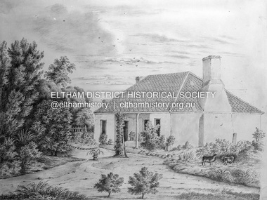
Negative - Photograph, Charles Bertie, Sketch; Sweeney's Cottage, Culla Hill, Eltham (n.d.), c.1905
In the early 1900s, Mary Sweeney commissioned artist Charles Bertie to paint the main house at Culla Hill. He charged her 5 shillings for the picture and 18 pence for the frame She took this painting with her when she married Michael Carrucan in 1910 and it hung in the Dalton Street farmhouse for many years. At a later time (1960s), the Burstons (the then owners of Culla Hill) had a card printed from the painting. The original sketch was photographed in 1970 for reproduction in the Shire history publication Pioneers & Painters (1971). The very fragile original was kept in the Council strongroom and suffered significant damage to its edges over the years, no doubt it has also yellowed. A comparison of the original as digitised (2022) with the negative taken 50 years earlier also reveals that the left 20% of the sketch has been cut off, probably due to damage. In June 1842 Thomas Sweeney applied to the Superintendent, C.J. La Trobe, asking permission to purchase a portion of the recently surveyed ‘Parish of Nillumbik'. His request was allowed and handed to the sub-treasurer and Land Board. He paid £110 for 110 acres and called the land 'Culla Hill'. He first built a temporary house, a slab hut 12 feet by 10 feet, in which he lived with his wife, an Irish girl whom he had married in 1838. (His first wife had been drowned at Port Jackson.) Some time later he built a permanent residence on the model of a Tipperary farmhouse. It was a rectangular building of hand-made bricks and stone quarried from the Western Hill with a recessed verandah in front, and bore a slate roof. The out-buildings consisted of a detached kitchen, stable and a barn. It was in this house that succeeding generations of Sweeneys were reared. The original slab hut became a washhouse and survived till recent years. 'Culla Hill' became a social centre for the district, church services being held there on various occasions. The first wheat crop in the district was planted by Sweeney who also supplied the first grain for a mill that later was built at Eltham. He took an active interest in the development of the district. At this time travelling people--many of them runaway sailors or convicts--often passed the settlement, and some of them stayed and worked with Sweeney. A tribe of aborigines living on the river below 'Culla Hill' were apparently on good terms with Sweeney, for it is said that they helped him with the building of his house. Very little is known about the aborigines who originally lived in the Eltham district. There must have been many of them; their stone axes, grinding stones, and anvil stones have been found in the gullies around Research and canoe trees and artifacts were found on the Kangaroo Ground hills. Early settlers remembered a tribe that camped on the site of the present railway bridge at Eltham. They held corroborees there and visited settlers for hand-outs of 'flour and bacca’. There was an aboriginal reserve on the Yarra, upstream from Eltham, but most of those who had collected there later went to live on the Pound Reserve at Warrandyte, where the last aborigines in the area finally ended their days. The Pound Reserve, of 1,103 acres, was established at Pound Bend in 1841. The chief protector, George Robinson, and his four assistants, were given instructions to care for the aged and sick, to provide blankets and rations for all who lived there, to train the able-bodied men in agriculture and other trades and to find them jobs. The Yarra blacks, who later came under the protection of William Thomas, have been described as a 'fine race, well made and above the average height'. Thomas Sweeney died on 6 September 1867 and was buried in the Eltham Cemetery. To his wife Margaret and his son John, he left the entire property of 'Culla Hill'. To his other son Patrick, he left 150 acres, including a small two-roomed wooden cottage. He had five daughters: Kate and Margaret (twins) who were born in 1842, Ellen 1846, Annie 1848 and Johanna 1851. John Sweeney farmed 'Culla Hill' until his death in 1909. He had ten children; one of them, Mary, became Mrs M. Carrucan whose son, Mr John Carrucan, still lives at Eltham. 'Culla Hill' passed out of the Sweeneys possession in 1939 and was renamed by its new owners, 'Sweeneys', in memory of its pioneers. - Pioneers & Painters: One Hundred Years of Eltham and its Shire, Alan Marshall 1971, pp10-12 Original colour sketch artwork 4 x 5 inch black and white negative of original colour sketchculla hill, art, charles bertie, drawing, mary carrucan (nee sweeney), sketches, sweeney's cottage