Showing 22330 items
matching parks
-
 St Kilda Historical Society
Photograph - Photo map, 11/01/1968
One of a series of photo-maps produced for the Department of Crown Lands and Survey (1857-1983). For correlation with a current map, and access to other historical photo maps of Victoria, see the Historic Photo-Maps Index published by the Department of Environment, Land, Water and Planning at https://services.land.vic.gov.au/DELWPmaps/historical-photomaps/Black and white aerial photographVic 2132 State Aerial Survey Melbourne 1968 Proj Run 27E 11.1.68 5100 ASL 65caulfield north, caulfield park, armadale, malvern, 1968 -
 St Kilda Historical Society
Photograph - Photo map, 11/01/1968
One of a series of photo-maps produced for the Department of Crown Lands and Survey (1857-1983). For correlation with a current map, and access to other historical photo maps of Victoria, see the Historic Photo-Maps Index published by the Department of Environment, Land, Water and Planning at https://services.land.vic.gov.au/DELWPmaps/historical-photomaps/Black and white aerial photographVic 2132 State Aerial Survey Melbourne 1968 Proj Run 27E 11.1.68 5100 ASL 67st kilda east, st kilda cemetery, caulfield north, alma park, balaclava, armadale, 1968 -
 St Kilda Historical Society
Photograph - Photo map, 13/01/1968
One of a series of photo-maps produced for the Department of Crown Lands and Survey (1857-1983). For correlation with a current map, and access to other historical photo maps of Victoria, see the Historic Photo-Maps Index published by the Department of Environment, Land, Water and Planning at https://services.land.vic.gov.au/DELWPmaps/historical-photomaps/Black and white aerial photograph2138 State Aerial Survey Melbourne 1968 Proj. Run 26 13.1.68 5100 ASL 203st kilda west, albert park, fawkner park, south yarra, prahran, windsor, 1968 -
 St Kilda Historical Society
Photograph - Photo map, 11/01/1968
One of a series of photo-maps produced for the Department of Crown Lands and Survey (1857-1983). For correlation with a current map, and access to other historical photo maps of Victoria, see the Historic Photo-Maps Index published by the Department of Environment, Land, Water and Planning at https://services.land.vic.gov.au/DELWPmaps/historical-photomaps/Black and white aerial photographVic 2132 State Aerial Survey Melbourne 1968 Proj. Run 27E 11.1.68 5100 ASL 69st kilda, albert park, st kilda east, st kilda beach, alma park, windsor, prahran, 1968 -
 St Kilda Historical Society
Photograph - Photo map, 11/01/1968
One of a series of photo-maps produced for the Department of Crown Lands and Survey (1857-1983). For correlation with a current map, and access to other historical photo maps of Victoria, see the Historic Photo-Maps Index published by the Department of Environment, Land, Water and Planning at https://services.land.vic.gov.au/DELWPmaps/historical-photomaps/Black and white aerial photographVic 2132 State Aerial Survey Melbourne 1968 Proj. Run 29E 11.1.68 5100 ASL 194elwood, elwood beach, elwood park, elsternwick park, ripponlea, elwood canal, balaclava, st kilda, 1968 -
 St Kilda Historical Society
Photograph - Photo map, 11/01/1968
One of a series of photo-maps produced for the Department of Crown Lands and Survey (1857-1983). For correlation with a current map, and access to other historical photo maps of Victoria, see the Historic Photo-Maps Index published by the Department of Environment, Land, Water and Planning at https://services.land.vic.gov.au/DELWPmaps/historical-photomaps/Black and white aerial photographVic 2132 State Aerial Survey Melbourne 1968 Proj. Run 27E 11.1.68 5100 ASLst kilda, st kilda west, st kilda pier, catani gardens, st kilda beach, albert park, 1968 -
 St Kilda Historical Society
Photograph - Photo map, 11/01/1968
One of a series of photo-maps produced for the Department of Crown Lands and Survey (1857-1983). For correlation with a current map, and access to other historical photo maps of Victoria, see the Historic Photo-Maps Index published by the Department of Environment, Land, Water and Planning at https://services.land.vic.gov.au/DELWPmaps/historical-photomaps/Black and white aerial photographVic 2132 State Aerial Survey Melbourne 1968 Proj. Run 29E 11.1.68 5100 ASL 196elwood, elwood park, elwood canal, elwood beach, st kilda marina, mc moran reserve, point ormond, 1968 -
 St Kilda Historical Society
Photograph - Photo map, Department of Crown Lands and Survey (1857-1983), 22/01/1970
One of a series of photo-maps produced for the Department of Crown Lands and Survey (1857-1983). For correlation with a current map, and access to other historical photo maps of Victoria, see the Historic Photo-Maps Index published by the Department of Environment, Land, Water and Planning at https://services.land.vic.gov.au/DELWPmaps/historical-photomaps/Black and white aerial photographVic 2358 Department of Crown Lands and Survey Victoria,.© Melbourne 1970 Project Run 42E 22.1.70 5,100 ASL 77st kilda, st kilda east, st kilda marina, elwood, elwood canal, elsternwick park, point ormond, balaclava, mc moran reserve, ripponlea, st kilda botanical gardens, peanut farm, 1970 -
 St Kilda Historical Society
Photograph - Photo map, Department of Crown Lands and Survey, 22/01/1970
One of a series of photo-maps produced for the Department of Crown Lands and Survey (1857-1983). For correlation with a current map, and access to other historical photo maps of Victoria, see the Historic Photo-Maps Index published by the Department of Environment, Land, Water and Planning at https://services.land.vic.gov.au/DELWPmaps/historical-photomaps/Black and white aerial photographVic 2358 Department of Crown Lands and Survey Victoria,.© Melbourne 1970 Project Run 43E 22.1.70 5,100 ASL 208elwood, elwood beach, point ormond, elwood park, elwood canal, mc moran reserve, 1970 -
 St Kilda Historical Society
Photograph - Photo map, Department of Crown Lands and Survey, 22/01/1970
One of a series of photo-maps produced for the Department of Crown Lands and Survey (1857-1983). For correlation with a current map, and access to other historical photo maps of Victoria, see the Historic Photo-Maps Index published by the Department of Environment, Land, Water and Planning at https://services.land.vic.gov.au/DELWPmaps/historical-photomaps/Black and white aerial photographCONTROLLED Vic 2358 Department of Crown Lands and Survey Victoria,.© Melbourne 1970 Project Run 41E 22.1.70 5,100 ASL 66st kilda, albert park, st kilda west, catani gardens, st kilda botanical gardens, st kilda pier, st kilda beach, 1970 -
 St Kilda Historical Society
Photograph - Photo map, 14/12/1963
One of a series of photo-maps produced for the Department of Crown Lands and Survey (1857-1983). For correlation with a current map, and access to other historical photo maps of Victoria, see the Historic Photo-Maps Index published by the Department of Environment, Land, Water and Planning at https://services.land.vic.gov.au/DELWPmaps/historical-photomaps/Black and white aerial photographVic 1807 Melbourne 1963 Project Run 16 14.12.1963 Lens 205 152.70 M/M 5.150 177st kilda, st kilda pier, catani gardens, middle park, albert park, st kilda west, st kilda beach, 1963 -
 St Kilda Historical Society
Photograph - Photo map, Department of Crown Lands and Survey, 22/01/1970
One of a series of photo-maps produced for the Department of Crown Lands and Survey (1857-1983). For correlation with a current map, and access to other historical photo maps of Victoria, see the Historic Photo-Maps Index published by the Department of Environment, Land, Water and Planning at https://services.land.vic.gov.au/DELWPmaps/historical-photomaps/Black and white aerial photographVic 2358 Department of Crown Lands and Survey Victoria,.© Melbourne 1970 Project Run 41E 22.1.70 5,100 ASL 64st kilda, st kilda cemetery, balaclava, st kilda east, windsor, caulfield north, alma park, 1970 -
 St Kilda Historical Society
Photograph - Photo map, Department of Crown Lands and Survey, 08/01/1970
One of a series of photo-maps produced for the Department of Crown Lands and Survey (1857-1983). For correlation with a current map, and access to other historical photo maps of Victoria, see the Historic Photo-Maps Index published by the Department of Environment, Land, Water and Planning at https://services.land.vic.gov.au/DELWPmaps/historical-photomaps/Black and white arial photographVic 2345 Department of Crown Lands and Survey Victoria,.© Melbourne 1970 Project Run 40 8.1.70 5,100 ASL 77albert park, fawkner park, south yarra, middle park, prahran, windsor, st kilda, st kilda west, 1970 -
 St Kilda Historical Society
Photograph - Photo map, 22/01/1970
One of a series of photo-maps produced for the Department of Crown Lands and Survey (1857-1983). For correlation with a current map, and access to other historical photo maps of Victoria, see the Historic Photo-Maps Index published by the Department of Environment, Land, Water and Planning at https://services.land.vic.gov.au/DELWPmaps/historical-photomaps/Black and white aerial photographVic 2358 Department of Crown Lands and Survey Victoria,.© Melbourne 1970 Project Run 43E 22.1.70 5,100 ASL 206elwood, elsternwick, elsternwick park, 1970 -
 St Kilda Historical Society
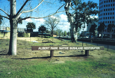
Photograph, Albert Park Native Bushland Restoration Project 1991 - images collection
The bushland area near the Corroborree Tree, near the corner of Fitzroy Street St Kilda and the Queens Road offramp from St Kilda Road, was restored in 1991 by Earthcare.Colour photographsst kilda junction, corroboree tree, albert park native bushland, 1991, earthcare, ngargee tree, james williams, albert park -
 St Kilda Historical Society
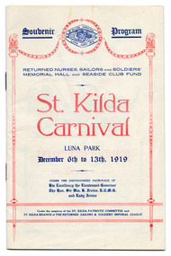
Ephemera - Special event program, St Kilda Carnival Souvenir Program, 1919
Fundraising for Returned Nurses Sailors and Soldiers Memorial Hall and Seaside Club Fund. The Memorial Hall was entirely community-funded.Multi-page document printed in blue and red on 8 sheets of white paper that has discoloured with age, folded and fastened with 2 staples. luna park, st kilda patriotic committee, st kilda carnivals, memo, st kilda memorial hall -
 St Kilda Historical Society
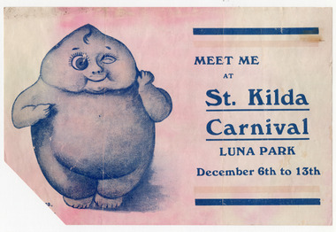
Ephemera - Flyer, Meet me at St. Kilda Carnival, 1919
Full date of event not given. It may refer to the St Kilda Carnival of 6-13 December 1919 which raised funds for the Returned Nurses Sailors and Soldiers Memorial Hall and Seaside Club Fund. White paper discoloured with age, printed on one side in blue.luna park, st kilda carnivals -
 St Kilda Historical Society
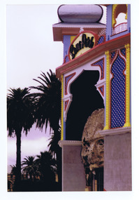
Photograph, Luna Park
Taken before 2011-2012 renovation of the entrance facecolour photography, unmounted, original, fair condition -
 Tatura Irrigation & Wartime Camps Museum
Certificate of Title, Subdivisions, 1879 and 1930
Title Deeds for property in Tatura2 certificates of title showing subdivisions made over several years. Vol. 5655:Folio 1130935 dated 16/5/1930 and Vol.1182: Folio 236330 dated 23/12/1869. Lease between Thomas Hogan and W F Bazeley dated 7th July 1911 for land in Hogan Street known as Slaughter Yard Paddock .Also lease dated 1911. In buff coloured legal envelope with number "2678" and "Hogan - Thomas" written in red on outside.tatura, relationship folders, certificate of title, lease, thomas hogan, john hogan, john james hanlon, edward glover, arthur burke, james brady, andrew collie, jean hunter, sydney embling, john maher, arthur goyen, patrick o'toole, philipe dove, george wildon, edwin harden, cuthbert corke, lee chung, hugh barnes, george manning, francis williams, john fawkner, michael walshe, alexander ferguson, rose gullett, john gibb, william taylor, richard casey, anthony grover, arthur grover, charles brady, elizabeth davey, frank williams, honora culkin, alexander park, stephen reville, richard carr, charles grover, henry mccarthy, james bruce, edward hanley, chew yen, ah poy, loo way, ah dick, charles mitchell, lionel martin, douglas forsyth, catherine wilson, mabel heath, patrick mcnamara, micheal cussen, james wilson, bazeley, documents, legal -
Tatura Irrigation & Wartime Camps Museum
Book - Family History, A Starritt Family history, April 1982
Starritt Family history.Tan, linen finish cover. Soft front cover. Front "A Starritt Family History" in cream lettering. "A Starritt Family History" and " John D Starritt" on spine. Illustrated. N. G. Starritt G. R. Starritt. With compliments from the Starritts.starritt family, kelso park, family history -
Tatura Irrigation & Wartime Camps Museum
Folder - family history, Brady Family History, Tatura, from earliest Settlement in 1874
Collection of items of interest, relative to Brady Family History, including photographs, verbal descriptions and reports of family interestComprehensive report of Brady family life from earliest settlement 1874, Taturabrady, mccarthy m, tatura, meath park, documents, reports, moriaty, curtis -
Tatura Irrigation & Wartime Camps Museum
Book, From Paddock to Park
To record the history of Tatura Cricket Club from 1880-1985-2003. Includes program for launch of bookGreen cover, white writing. Sketch of tree and wicket and batsport in tatura, tatura cricket club, books, history, local, sport -
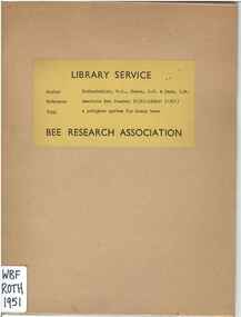 Wheen Bee Foundation
Publication, Rothenbuhler, W. C., Gowen, J. W. & Park, O. W, A pedigree system for honey bees (Rothenbuhler, W. C., Gowen, J. W. & Park, O. W.), London, 1951, 1951
-
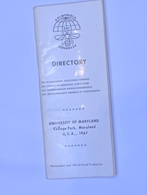 Wheen Bee Foundation
Publication, Apimondia XXI Congress Directory (University Of Maryland - College Park, Maryland USA, 1967), 1967
Soft cover narrow book, white with black writing 75 pages -
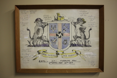 Wangaratta RSL Sub Branch
Work on paper - Coat of Arms, Rats of Tobruk 1941, 1941
Hand drawn Coat of Arms for the soldiers known as the Rats of Tobruk with signatures of those involved in the engagement between 5th April to the 22nd of October 1941 The drawing is signed by artist John DOWIE AM, SX6087 who served with the 2/43rd Battalion Signatories are: VX42389 Eric Hamilton, 2/32 Battalion; VX30189 F.Baldwin, 2/23 Battalion; VX34544, F.J.Mc.Intosh 2/24 Battalion; VX34554 W.Harrison, 2/24 Battalion; WX7281 P.Bone 2/25 Battalion; VX33719 Duke Goldsmith, 2/24 Battalion; VX41179 Harry Frazer, 2/24 Battalion; VX29652 A.R.Stribley, 2/24 Battalion; SX6367 Jack Foley, 2/43 Battalion; VX48340 Harry Jones, 2/23 Battalion; VX42317 Aub Jarrott, 2/24Battalion; VX28869 Rod Deering 2/24Battalion; VX15719 Ian F. Joss 7th Division AASC; VX19723 Len Dauria, 2/12 Field Regiment; NX35852 R.E (Snowy) Cornelius 2/13 Battalion; VX32559 Jim Gray, 2/24Battalion - James Cyril GRAY Born 6/1/1916 in Orroroo South Australia. Enlisted 28/5/1940 at Mildura. Awarded Military Medal for remarkable coolness, bravery and leadership at Tobruk on 24/4 and 1/5/1941. He was promoted to Sergeant on 14/8/1941, Lieutenant in November 1942 then Captain on 9/4/1945. He was wounded in action on 11/9/1943 and discharged on 20/12/1945. He married and had three children. He died on 10/4/1992 aged 76 and buried at Wangaratta Cemetery.This original drawing is by John DOWIE SX6087 who served with the 2/43rd Battalion during the second world war and is signed by the artist and soldiers from the 2/24th Battalion known as "Wangaratta's Own". John Stuart Dowie AM (15 January 1915 – 19 March 2008) was an Australian painter, sculptor and teacher. He was born in the suburb of Prospect in Adelaide, South Australia, and studied architecture at the University of Adelaide. During World War II, Dowie worked in the Military History Unit of the Australian Imperial Force, and as an assistant to Australia's official war sculptor, Lyndon Dadswell. As a soldier, he was one of the Rats of Tobruk. After studying art in London and Florence, Dowie returned to Australia. His work includes over 50 public sculpture commissions, including the "Three Rivers" fountain in Victoria Square, "Alice" in Rymill Park, the "Victor Richardson Gates" at Adelaide Oval and the "Sir Ross & Sir Keith Smith Memorial" at Adelaide Airport. He was made a Member of the Order of Australia in 1981 in recognition of service to the arts as a sculptor and painter. Dowie died on 19 March 2008, aged 93. There is a similiar version of the drawing on page 32 of the book Desert Sand and Jungle Green by Geoffrey Boss-Walker which is an illustrated history of the 2/43rd Battalion.Timber frame containing hand drawn Coat of Arms consisting of "rats" as shield supporters, crest with a swastika in the centre and motto surrounded by signatures.Signatures of artist John Dowie and soldiers engaged at Tobruk. The crest depicts a latrine and the motto reads NON FASCES SED FAECES (Latin translation - "Do not move but the dregs") rats of tobruk, coat of arms, 1941, john dowie -
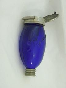 Historical Society of Mooroopna Inc.
Sputum Flask, Blue Glass Sputum Flask, circa1880
This sputum flask was used to help prevent the spread of disease especially by tuberculosis patients, through people spitting in public. They became know as a Blue Henry. They are made of Cobalt Glass, hence blue.These flasks were in wide use opera a period of about 50 years, and manufactured by many different manufacturersBlue Glass labelled Mignon. Large metal cap one end with spout inside glass beneath cap. Small metal cap at other end. Oval in shape."Mignon" both on large metal cap and on glasscobalt blue sputum flasks -
 Inverloch Historical Society
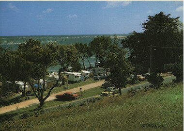
Postcard, Caravan Park & Anderson Inlet - Rose Series Colorview no 1548
-
 Inverloch Historical Society
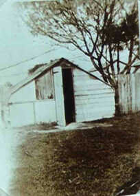
000544 - Photograph - Whiter's Caravan Park before 2nd War - C Newton
-
 Inverloch Historical Society
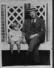
000045 - Photograph - Luna Park - circa1932 - G N Howsam - L G Howsam
-
 Robin Boyd Foundation
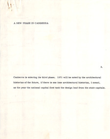
Document - Manuscript, Robin Boyd, A New Phase in Canberra, 1971
Describes Canberra as a city that has minimal architectural character, as it is mainly characterised by its natural landscape and roadways. The new phase in Canberra refers to several civic projects that will serve to define Canberra as a national capital.Original manuscript of the article 'A New Phase for Canberra' published in Sunday Australian, 05.09.1971.Typewritten (c copy), quarto, 9 pagescanberra, urban planning, walter burley griffin, capital circle, capital hill, campbell park, australian architecture, harry seidler, robin boyd, manuscript, national capital