Showing 19407 items
matching east
-
 National Vietnam Veterans Museum (NVVM)
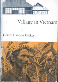
Book, Hickey, Gerald, Village in Vietnam
One of the struggles between East and West is taking place in South Vietnam, an area whose culture has been virtually unknown to scholars. The author has used the small village of Khanh Hau, in the Mekong River delta southwest of Saigon, as a microcosm for the study of the rural physical setting, the beliefs and customs of the several religions that exist here side by side, the kinship and family pattern, the crops and agricultural methods, the economic, administrative, the legal systems, and the socioeconomic structure and mobility.One of the struggles between East and West is taking place in South Vietnam, an area whose culture has been virtually unknown to scholars. The author has used the small village of Khanh Hau, in the Mekong River delta southwest of Saigon, as a microcosm for the study of the rural physical setting, the beliefs and customs of the several religions that exist here side by side, the kinship and family pattern, the crops and agricultural methods, the economic, administrative, the legal systems, and the socioeconomic structure and mobility.ethnology -- vietnam, anthropology, cultural, mekong river, khanh hau -
 National Vietnam Veterans Museum (NVVM)
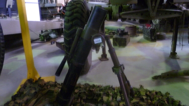
Weapon, 60mm Mortar, 1960's
The Chinese type 31 60mm Mortar is a copy of the US M2 Mortar. The mortar consists of a barrel, bipod and baseplate. The barrel is made from ordnance steel and has a smoothbore profile. the breech end has a ball and socket arrangement that fits into the baseplate. The tripod is adjustable for traverse and elevation and can be folded for transportation purposes and is fitted with a leather binding strap. The baseplate is square in profile and is made from pressed metal. A canvas carry strap is fitted through two loops in the top surface. There are anchor spikes at the bottom of the baseplate. The mortar is painted camouflage in black, brown and olive drab.INNOC. Serial numbers : Base Plate 9307 330937; Bipod 9364south east asia, vietnam, vietcong, weapon -
 St Kilda Historical Society
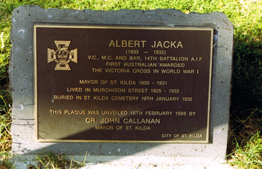
Photograph, Albert Jacka VC home (1925-32) - images collection
Lived in Murchison Street 1925-1932. Buried in St Kilda Cemetery 19th January 1932. Plaque was unvieled 18th Feb 1986 by Cr John Callanan, Mayor of St Kilda.Historiccolour photograph unmountedAlbert Jacka (1893-1932). VC, MC and BAR, 14th Battalion AIF. First Australian awarded the Victoria Cross in World War I. Mayor of St Kilda 1930-31. Lived in Murchison St 1925-1932. Buried in St Kilda Cemetary 19th January 1932. This plaque was unveiled 16th February 1986 by Councillor John Callanan, Mayor of St Kilda, City of St Kilda. plaques, albert jacka, murchison street, st kilda east, st kilda -
 St Kilda Historical Society
Photograph
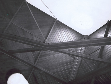
St John’s Congregational Church was established in 1888 on the corner of Barkly and Mitford Streets, near the Village Belle Hotel in South St Kilda. The building has now been demolished. The photograph was taken at the final service. The church closed in 1974 and gave its hymn books, carpets and curtains to its sister church, East St Kilda Congregational Church at the corner of Hotham and Inkerman Streets (later East St Kilda Uniting Church and now Trinity-St Nicholas Church).black and white photographPortion of ceiling of St John Cong. Church South S Kilda. Closing Service 31 Dec 1973st kilda, churches, st john's congregational church, congregational churches -
 St Kilda Historical Society
Photograph - Photo map, 17/01/1951
One of a series of photo-maps produced for the Department of Crown Lands and Survey (1857-1983). For correlation with a current map, and access to other historical photo maps of Victoria, see the Historic Photo-Maps Index published by the Department of Environment, Land, Water and Planning at https://services.land.vic.gov.au/DELWPmaps/historical-photomaps/Black and white aerial photograph1414-20 538 Run 19 Lens 12" Melbourne Metropolitan 12150 17.1.51 M586elwood, elsternwick, st kilda east, balaclava, ripponlea, 1951 -
 St Kilda Historical Society
Photograph - Photo map, 28/01/1951
One of a series of photo-maps produced for the Department of Crown Lands and Survey (1857-1983). For correlation with a current map, and access to other historical photo maps of Victoria, see the Historic Photo-Maps Index published by the Department of Environment, Land, Water and Planning at https://services.land.vic.gov.au/DELWPmaps/historical-photomaps/Black and white aerial photograph1424-43 534 Run 18 Lens 12" Melbourne Metropolitan 12150 28.1.51 M639armadale, malvern, st kilda cemetery, caulfield north, st kilda east, 1951 -
 St Kilda Historical Society
Photograph - Photo map, 30/01/1960
One of a series of photo-maps produced for the Department of Crown Lands and Survey (1857-1983). For correlation with a current map, and access to other historical photo maps of Victoria, see the Historic Photo-Maps Index published by the Department of Environment, Land, Water and Planning at https://services.land.vic.gov.au/DELWPmaps/historical-photomaps/Black and white aerial photographVic 1092-40 Melbourne & Metropolitan Project Run 22 30.1.60 Lens 10" 8.200st kilda east, balaclava, ripponlea, st kilda cemetery, 1960 -
 St Kilda Historical Society
Photograph - Photo map, 30/01/1960
One of a series of photo-maps produced for the Department of Crown Lands and Survey (1857-1983). For correlation with a current map, and access to other historical photo maps of Victoria, see the Historic Photo-Maps Index published by the Department of Environment, Land, Water and Planning at https://services.land.vic.gov.au/DELWPmaps/historical-photomaps/Black and white aerial photographVic 1091-110 Melbourne & Metropolitan Project Run 23East 30.1.60 Lens 10" 8.200elwood, elsternwick, elsternwick park, ripponlea, st kilda east, caulfield, balaclava, 1960 -
 St Kilda Historical Society
Photograph - Photo map, 14/12/1963
One of a series of photo-maps produced for the Department of Crown Lands and Survey (1857-1983). For correlation with a current map, and access to other historical photo maps of Victoria, see the Historic Photo-Maps Index published by the Department of Environment, Land, Water and Planning at https://services.land.vic.gov.au/DELWPmaps/historical-photomaps/Black and white aerial photographVic 1807 Melbourne 1963 Project Run 16 14.12.63 Lens 205 152.70 M/M 5.150 179st kilda, prahran, albert park, st kilda east, balaclava, 1963 -
 St Kilda Historical Society
Photograph - Photo map, 14/12/1963
One of a series of photo-maps produced for the Department of Crown Lands and Survey (1857-1983). For correlation with a current map, and access to other historical photo maps of Victoria, see the Historic Photo-Maps Index published by the Department of Environment, Land, Water and Planning at https://services.land.vic.gov.au/DELWPmaps/historical-photomaps/Black and white aerial photographVic 1807 Melbourne 1963 Project Run 16 14.12.63 Lens 205 152.70 M/M 5.150 181st kilda cemetery, caulfield north, st kilda east, armadale, malvern, 1963 -
 St Kilda Historical Society
Photograph - Photo map, 12/04/1966
One of a series of photo-maps produced for the Department of Crown Lands and Survey (1857-1983). For correlation with a current map, and access to other historical photo maps of Victoria, see the Historic Photo-Maps Index published by the Department of Environment, Land, Water and Planning at https://services.land.vic.gov.au/DELWPmaps/historical-photomaps/Black and white aerial photographVic 1933 Melbourne 1966 Project Run 12 12.4.66 Lens 122 151.75MM 9.800 154st kilda, st kilda east, balaclava, toorak, amadale, caulfield, south yarra, st kilda botanical gardens, peanut farm, 1966 -
 St Kilda Historical Society
Photograph - Photo map, 08/02/1966
One of a series of photo-maps produced for the Department of Crown Lands and Survey (1857-1983). For correlation with a current map, and access to other historical photo maps of Victoria, see the Historic Photo-Maps Index published by the Department of Environment, Land, Water and Planning at https://services.land.vic.gov.au/DELWPmaps/historical-photomaps/Black and white aerial photographVic 1916 Melbourne 1966 Project Run 13 E 8.2.66 Lens 122 151.75MM 9.800 111st kilda, balaclava, caulfield, caulfield north, st kilda east, elsternwick, elsterwick park, elwood park, elwood canal, elwood beach, ripponlea, 1966 -
 St Kilda Historical Society
Photograph - Photo map, 11/01/1968
One of a series of photo-maps produced for the Department of Crown Lands and Survey (1857-1983). For correlation with a current map, and access to other historical photo maps of Victoria, see the Historic Photo-Maps Index published by the Department of Environment, Land, Water and Planning at https://services.land.vic.gov.au/DELWPmaps/historical-photomaps/Black and white aerial photographVic 2132 State Aerial Survey Melbourne 1968 Proj Run 27E 11.1.68 5100 ASL 67st kilda east, st kilda cemetery, caulfield north, alma park, balaclava, armadale, 1968 -
 St Kilda Historical Society
Photograph - Photo map, 11/01/1968
One of a series of photo-maps produced for the Department of Crown Lands and Survey (1857-1983). For correlation with a current map, and access to other historical photo maps of Victoria, see the Historic Photo-Maps Index published by the Department of Environment, Land, Water and Planning at https://services.land.vic.gov.au/DELWPmaps/historical-photomaps/Black and white aerial photographVic 2132 State Aerial Survey Melbourne 1968 Proj. Run 27E 11.1.68 5100 ASL 69st kilda, albert park, st kilda east, st kilda beach, alma park, windsor, prahran, 1968 -
 St Kilda Historical Society
Photograph - Photo map, 11/01/1968
One of a series of photo-maps produced for the Department of Crown Lands and Survey (1857-1983). For correlation with a current map, and access to other historical photo maps of Victoria, see the Historic Photo-Maps Index published by the Department of Environment, Land, Water and Planning at https://services.land.vic.gov.au/DELWPmaps/historical-photomaps/Black and white aerial photographVic 2132 State Aerial Survey Melbourne 1968 Proj. Run 28E 11.1.68 5100 ASL 81st kilda, balaclava, st kilda east, ripponlea, elwood, elsternwick, caulfield, st kilda botanical gardens, 1968 -
 St Kilda Historical Society
Photograph - Photo map, Department of Crown Lands and Survey (1857-1983), 22/01/1970
One of a series of photo-maps produced for the Department of Crown Lands and Survey (1857-1983). For correlation with a current map, and access to other historical photo maps of Victoria, see the Historic Photo-Maps Index published by the Department of Environment, Land, Water and Planning at https://services.land.vic.gov.au/DELWPmaps/historical-photomaps/Black and white aerial photographVic 2358 Department of Crown Lands and Survey Victoria,.© Melbourne 1970 Project Run 41E 22.1.70 5,100 ASL 62caulfield, caulfield north, st kilda east, armadale, 1970 -
 St Kilda Historical Society
Photograph - Photo map, 14/12/1963
One of a series of photo-maps produced for the Department of Crown Lands and Survey (1857-1983). For correlation with a current map, and access to other historical photo maps of Victoria, see the Historic Photo-Maps Index published by the Department of Environment, Land, Water and Planning at https://services.land.vic.gov.au/DELWPmaps/historical-photomaps/Black and white aerial photographVic 1807 Melbourne 1963 Project Run 17 14.12.63 Lens 205 152.70 M/M 5.150 36st kilda, st kilda botanical gardens, balaclava, st kilda east, elwood canal, ripponlea, caulfield north, elwood, caulfield, 1963 -
 St Kilda Historical Society
Photograph - Photo map, Department of Crown Lands and Survey (1857-1983), 22/01/1970
One of a series of photo-maps produced for the Department of Crown Lands and Survey (1857-1983). For correlation with a current map, and access to other historical photo maps of Victoria, see the Historic Photo-Maps Index published by the Department of Environment, Land, Water and Planning at https://services.land.vic.gov.au/DELWPmaps/historical-photomaps/Black and white aerial photographVic 2358 Department of Crown Lands and Survey Victoria,.© Melbourne 1970 Project Run 42E 22.1.70 5,100 ASL 77st kilda, st kilda east, st kilda marina, elwood, elwood canal, elsternwick park, point ormond, balaclava, mc moran reserve, ripponlea, st kilda botanical gardens, peanut farm, 1970 -
 St Kilda Historical Society
Photograph - Photo map, Department of Crown Lands and Survey, 22/01/1970
One of a series of photo-maps produced for the Department of Crown Lands and Survey (1857-1983). For correlation with a current map, and access to other historical photo maps of Victoria, see the Historic Photo-Maps Index published by the Department of Environment, Land, Water and Planning at https://services.land.vic.gov.au/DELWPmaps/historical-photomaps/Black and white aerial photographVic 2358 Department of Crown Lands and Survey Victoria,.© Melbourne 1970 Project Run 41E 22.1.70 5,100 ASL 64st kilda, st kilda cemetery, balaclava, st kilda east, windsor, caulfield north, alma park, 1970 -
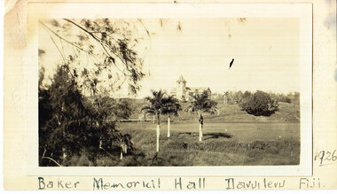 The Foundling Archive
Baker Memorial Hall Fiji 1926, 1926
Photograph taken in 1926 of Baker memorial hall in Fiji. contact print form glass plate? Direct paper exposure? Fiji Missionary? architecture, travel, historicalBlack and white photograph adhered to cardboard. Slight light damage (fogging LHT corner) and minor yellowing. -
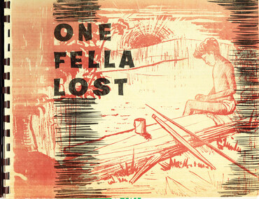 The Foundling Archive
Book, One Fella Lost, c.1920-1940
Picture story book written by Mission teacher, Miss Muriel Burthon, with illustrations based on drawings by Nugget James, from the Baptist Mission, Warrabri Native Settlement, Northern Territory. The book is published by Mission Publications Australia. This book states its uses as: as a story book and as an evangelizing tool. Historic Significance: this item reflects the nature of the relationship between Indigenous residents of Aboriginal missions and the mission masters. It provides an indication of the perception and representation of indigenous Australians during the early to mid- 20th Century. This item is a tangible reminder of the systematic captivity of indigenous Australians across the late 19th and 20th Centuries. Ring-bound paperback publication."One/Fella/Lost"aboriginal mission, indigenous history, colonialism, christianity, -
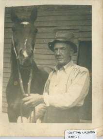 The Foundling Archive
dad with horse
Photograph taken between c1930-1950. This item is part of the West Sydney Collection. Which details the period around the Second World War from the perspective of a young woman and her family. photograph'dad' handwritten on the backsecond world war; west sydney; dad; horse; 1940's; australia -
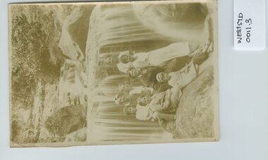
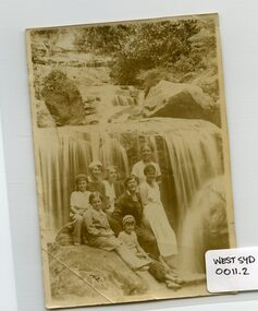 The Foundling Archive
Photograph- waterfall and ladies
This photograph is part of the West Sydney Collection which depicts the period around Second World War in Australia from the perspective of a young unknown woman.photograph - fading evidentwest sydney; australia; waterfalls; women; holidays -
 The Foundling Archive
waterfalls and ladies 2
This photograph is part of the West Sydney Collection which depicts the period around Second World War in Australia from the perspective of a young unknown woman.1935 Mum in beret, Aunt Elizabeth in black, me in front inberetwaterfalls; west sydney; australia; women; second world war -
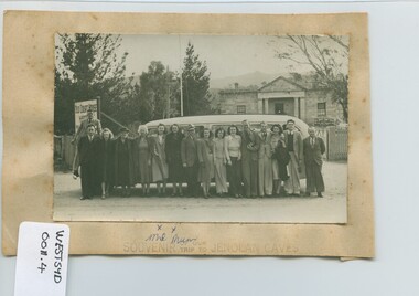 The Foundling Archive
Photograph-Souvenir of our trip to Jenolan Caves
This photograph is part of the West Sydney Collection which depicts the period around Second World War in Australia from the perspective of a young unknown woman.west sydney; australia; mum: holiday; jenolan caves: 1940's; second worldwar -
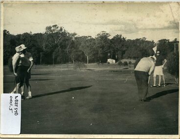 The Foundling Archive
Photograph- golf
This photograph is part of the West Sydney Collection which depicts the period around Second World War in Australia from the perspective of a young unknown woman.This photograph is part of the West Sydney Collection which depicts the period around Second World War in Australia from the perspective of a young unknown woman.golf: sport; west sydney; australia -
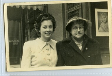 The Foundling Archive
Photograph- me and mum
This photograph is part of the West Sydney Collection which depicts the period around Second World War in Australia from the perspective of a young unknown woman.photographW139.11 Me, Mum G. McGrath PS HER MAJESTY'S ARCADE, SYDNEY extra copies are obtainable by quoting numberwest sydney; mcgrath; mum; australia; 1940s; second world war -
 The Foundling Archive
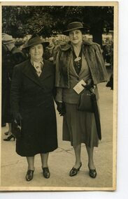
Photograph, Friend and mum
This photograph is part of the West Sydney Collection which depicts the period around Second World War in Australia from the perspective of a young unknown woman.PhotographFriend and Mum at Randwick races 1940's; west sydney; australia; randwick races -
 The Foundling Archive
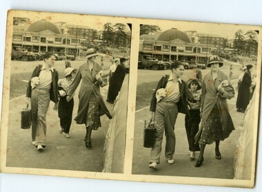
Jim, Me, Mum, George
This photograph is part of the West Sydney Collection which depicts the period around Second World War in Australia from the perspective of a young unknown woman.PhotographJim, me, mum,George, 19361930's; west sydney: brothers; sisters; family -
 The Foundling Archive
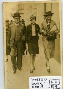
Photograph - me, mum walking
This photograph is part of the West Sydney Collection which depicts the period around Second World War in Australia from the perspective of a young unknown woman.PhotographMe, Mumwest sydney; australia; 1940s; 1930s