Showing 110195 items matching "roads"
-
 Ballarat Tramway Museum
Slide - 35mm slide/s, Travis Jeffrey, c1962
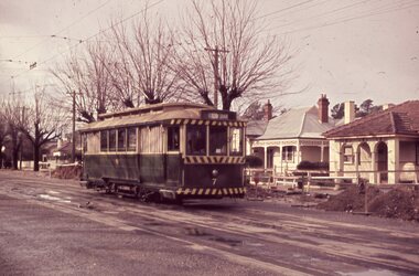
Agfa plastic mount (blue base, white cover) with a photo of Bendigo 7, at the north end of the Bridge St. Loop. Photo taken c1962. Note the road works in the background with the kerosene warning lamps and wooden protection barriers. House opposite tram is 122 Bridge St., which is part of a butchers shop (noted during 8/2004 visit)"BES 11" in penciltramways, trams, bendigo, north bendigo, mccrae st, road works, tram 7 -
 Ballarat Tramway Museum
Postcard, Tramway Museum Society of Victoria (TMSV), South Melbourne depot 1950's
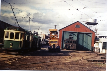
Yields information about the appearance of BTM owned tram No. 8 Scrubber when in MMTB service at the South Melbourne Per way depot.Printed colour photograph in the form of a postcard, of the Perway yard at South Melbourne depot 1950's with grinder car No. 2 and other service trams and a tower truck. No. 8 is the MMTB green and cream colour scheme. Has the two road Perway yard shed in the view. TMSV publication On the rear is a postcard framework and in the address portion a written inscription.In red ink, "Sth Melb Perway yard scrubber 8w, with cabins from PMTT 32"trams, tramways, south melbourne, mmtb, scrubber tram, tower truck -
 Ballarat Tramway Museum
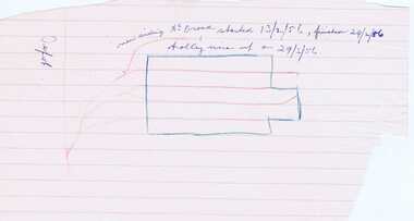
Drawing, Wal Jack, Sketch of "0" Road at SEC Depot, 1956?
Yields information about construction of "0" road at the Ballarat Tram Depot.Sketch showing the Ballarat tram depot with "0" road sketched in and handwritten notes about the date it was started, finished and the overhead or trolley wire put up in Feb. 1956. Items were contained within Reg Item 5507 - Foolscap binder with green covers, black binding edge and metal clips - see btm5507-list.pdf for actual location.depot, o road -
 Ballarat Tramway Museum
Document - Instruction, Melbourne and Metropolitan Tramways Board (MMTB), "Care of Plant", Jun. 1949
Set of five duplicated sheets, MMTB Permanent Way Department, Instructions regarding specific items of plant and their care. Each signed and dated 21 June 1949 by the Permanent Way Engineer. .1 - Drivers of Compressors (All Types) .2 - Power Saw .3 - Concrete Mixers .4 - Road Rollers (Steam Driven) .5 - Lewin Cleanerstrams, tramways, mmtb, equipment -
 Ballarat Tramway Museum
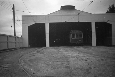
Photograph - Digital image, Wal Jack, 3/07/1938 12:00:00 AM
Yields information the appearance of the SEC tram depot in July 1938 and one of the tramcars.Digital image from the Wal Jack Ballarat Album of a the front of the SEC Ballarat Tram depot after refurbishment with No. 26 just in side the doorway on No. 3 road. Has a wooden fence alongside. Wal has dated the photo as 3/7/1938. See image i2 for rear of photograph. See image i4 for hi res scan of negativeOn rear of photo in pencil "3rd July 1938".trams, tramways, depot, sec, tram 26 -
 Ballarat Tramway Museum
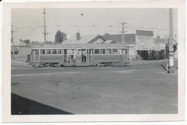
Photograph - Digital image, Ken Magor, 28/12/1950 12:00:00 AM
Yields information about the early use of Ballarat's bogie trams and the curve from Main Rd into Barkly St on the Mt Pleasant route.Digital image from the Wal Jack Ballarat Album of Ballarat 35 turning from Barkly St Mount Pleasant route into Main Road, 28-12-1950. Photo by Ken Magor. Shows the shops behind the tram - Milk bar - diary - advertising ice cream, Robur tea, fruits and confectionery. See image i2 for rear of photograph.On rear in ink "No. 35 from Mount Pleasant turning out of Barkly St into Main Street 28-12-50" and Ken Magor stamp with Neg No. "1901" written in.trams, tramways, mt pleasant, barkly st, main road, tram 35 -
 Ballarat Tramway Museum
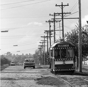
Photograph - Digital image, Peter Bruce, "No. 40 and Valiant", 1970s
Yields information about Albert St Sebastopol and the way the tram related to the roadway.Digital image of No. 40 southbound in Albert St Sebastopol with a Valiant motor car parked on the gravel portion of the road. Note the destination on the tram, Lydiard St North, either reset to early or forgot to change it. Photo taken by Peter Bruce 1970's and 1971, prior to the closure of the Ballarat tramway system. Peter's Title of image: "No. 40 and Valiant"trams, tramways, albert st, sebastopol, tram 40 -
 Ballarat Tramway Museum
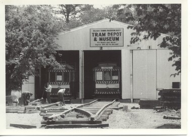
Photograph - Black & White Photograph/s, Dec. 1972
Yields information about the construction of the access track in April 1973 and some of the people involved.Black and white photograph of the construction of the track for the depot fan during 1972, the crossover between 2 and 3 roads is taking shape. No. 27 and 40 in the photograph. Photo appears on the front cover of the 1972-73 BTPS Annual Report and on page 4, credits Bob Prentice. See - 1972 - 1973 Annual Report list of dates on page 3.trams, tramways, depot, btps, construction, tram 27, tram 40 -
 Otway Districts Historical Society
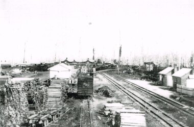
Photograph, Beech Forest Railway Station, 1910, 1910
By 1910 revenue from the Beech Forest railway was $15,500, working expenditure $12,000, with a net loss (including interest charges) of about $4,000. This and the following year were the lowest net losses ever experienced. Passenger journeys rose steadily, outwards goods traffic rose to a record 12,959 tons (in 1911), and inwards goods traffic was a record 3,359 tons.. The railway station possessed a goods shed, stock race and yards, engine shed, coal stage, crew cabins, a refreshment room, and a four-roomed station building, with the station staff to match. Beech Forest was the principal despatch centre at this stage for split timber. Bill Devitt laid a timber tramway to the Beech Forest railway station to cart the palings for on-shipment..B/W. 177mm x 271mm. A general view from the eastern end of Beech Forest station in 1910. Note the Goods Shed, three tracks with No.3 Road having a NU louvre van and loaded NQR wagons, timber stacks to the left, and Devitt's Tramway with unloaded trolleys at the lower left. To the right, crew cabins with shops and houses in the background.beech forest; railways; timber; tramway; -
 Otway Districts Historical Society
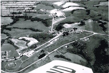
Photograph, R. Preston, Aerial view: Beech Forest, 1965, 13 February 1965
B/W. Aerial view of Beech Forest showing the complete station yard including the balloon loop (incorporating the two tennis courts), two ex-departmental residences, the station building and where the Colac and Crowes lines diverged. As well Beech Forest Hall, council offices and Shire Secretary's house, Denherts Track, and Main Road are shown.beech forest; railways; township; aerial; -
 Bendigo Historical Society Inc.
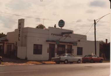
Photograph - BENDIGO HOTEL COLLECTION: FIFESHIRE HOTEL
Colour image, 'Fifeshire Hotel'. Single storey, white painted building, brown print 'Fifeshire Hotel' over entry. LH side of image 'Hotel' written down chimney of hotel. Hotel is art Deco style. Fifeshire Hotel is in Eaglehawk Road, in 2017 has been converted into a Medical Clinic. Image appears to be late 1970's?bendigo, hotel, fifeshire hotel -
 Bendigo Historical Society Inc.
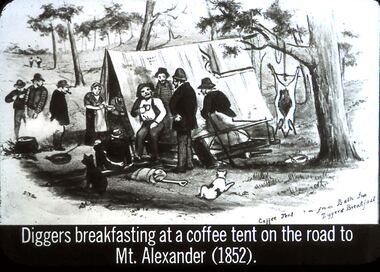
Slide - DIGGERS & MINING. STORES AT THE DIGGINGS, c1852
Diggers & Mining. Stores at the diggings. Diggers breakfasting at a coffee tent on the road to Mt. Alexander (1852). STG. Image from Bath Inn Diggers Breakfast. Image shows miners gathered around the Coffee Tent. The tent has a flag with emblem on it draped over the back corner of the tent. Markings: 36 994.LIF. 5. Used as a teaching aid.hanimounteducation, tertiary, goldfields -
 Bendigo Historical Society Inc.
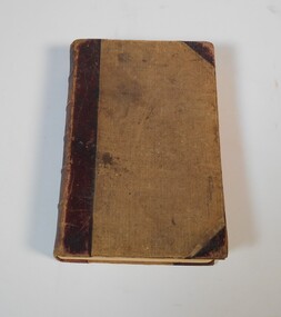
Book - Geographical dictionary
The Gazetteer presents an extensive a to z list of Victorian towns and villages, lakes, rivers and creeks, islands, bays, hills and mountains, runs and other localities and features. Entries include latitude and longitude, populations, proximity to other towns, local industries, coach and mail runs, hotels, churches and schools.Bailliere's Victorian Gazetteer and road guide containing the most recent and accurate information as to every place in the colony. Brown hardcover book, on the spine: Victorian Gazetteer with map 1865. The first and last pages are advertisements. The book has 442 pages listing every place in the colony. The map is not included. Compiled by Robert P. Whitworth. Published by Bailliere, Regent Street Unreadable name on first page and the name of F. Houston in blue pen on first page geographic dictionary, colony of victoria -
 Bendigo Historical Society Inc.
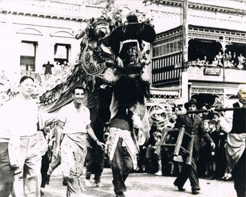
Photograph - PETER ELLIS COLLECTION: CHINESE DRAGON
Black and white photo of the Chinese Dragon in front of the Shamrock Hotel. One man is walking beside the Dragon's head carrying a stool. Date on the back is c 1950. Sign on verandah reads 'Australian legion of ex servicemen and women'. Both signs on tram post in middle of road read, 'All Cars Stop Here', (indication of a tram stop)photo, group, easter procession, peter ellis collection, chinese dragon, bendigo chinese association -
 Ballarat Tramway Museum
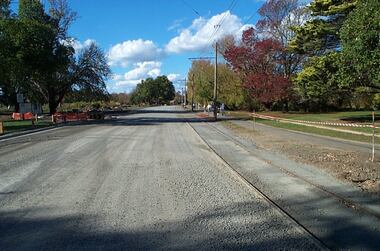
Photograph - Digital image Set of 12, Warren Doubleday, Wendouree Parade roadworks - April and May 2003, 27/4/2003 and 5/5/2003
Set of 12 Digital Images of the reconstruction of the roadway at the north end or near St Aidans drive that was part of the project to lift the road above flood level. Images show the work in progress and at the tram terminus itself. The gutter was moved to the north and later on the gate pillar was shifted to the north as well. Photos dated 27/4/2003 and 5/5/2003.trams, tramways, road works, st aidans drive, wendouree parade, tram track -
 Kew Historical Society Inc
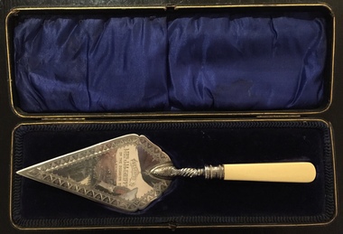
Ceremonial object - Presentation Trowel, Kew Baptist Church School Hall, Phillip Ashberry & Sons, 1905
"Infant Department The interest in this branch of the school work (under the able guidance of Misses F. Chapman and A.E. Ratten) is well maintained. It is largely through the generosity of Nr. and Mrs. Griffiths that the officers were enabled to have a new brick school hall built. The foundation stone was laid on 21st October, 1905, by Mrs. John M. Griffiths, the new building being erected on the site of the old church. It is both attractive and comfortable and is well lighted. It is also used for the week-night services. The old building which for so long had served as a schoolroom for the little ones was not considered suitable and was in 1905 disposed of for removal. When removed it was renovated, and is now used as a mission church in a neighbouring district." Source: Kew Baptist Church History 1856-1906The trowel is historically significant for its association with the Kew Baptist Church and its ownership by and association with the Griffiths family of Kew who were important tea merchants in Australia.Silver-plated commemorative trowel with bone handle, in black leather case lined with blue velvet. The trowel is engraved with information about the occasion.It was presented to Mrs J.M. Griffiths, who lived at Goldthorns, Normanby Road, Kew. [The trowel in its case was presented to the Kew Historical Society on 24 April 2018 by the Manager of Bupa Aged Care, Edithvale.]Engraved front: "Presented to Mrs. J.M. Griffiths on the occasion of her laying the foundation stone of the Baptist School Hall, Kew, Oct 21st 1905". Maker mark on reverse: "PA & S E P"griffiths family - kew (vic), mrs. j.m. griffiths, commemorative objects, baptist church (kew), presentation trowels -
 Tennis Australia
Poster, Advertisement, Circa 1885, Circa 2000
A digital print of an original 1880's advertisement, depicting a mixed doubles game of tennis, played on a lawn in front of a mansion, within the grounds of an estate. Inscription: ESTABLISHED 1856/PROSSER & SONS/LAWN TENNIS RACKET & BALL./MANUFACTURERS/200 PENTONVILLE ROAD/LONDON/ARMITAGE & IBBETSON, LITHO. BRADFORD. Materials: Paper, Ink, Cardboard, Glass, Metal, Foamcoretennis -
 Kew Historical Society Inc
Print, Post Office and Police Court Kew, 1907-1915
The Kew Historical Society's postcard collection includes views of Kew, Melbourne and Greater Melbourne as well as those including overseas scenes sent or received from Europe or the Middle East. They date from the 1890s to the 2000s. These postcards may or may not include the name of the publisher or printer. A number of the cards were published as parts of popular series. A way of dating early postcards is to identify whether the reverse was divided by a central line which became the norm after 1902 in the United Kingdom. However, other postcards produced after this date do not always conform to this print layout.An enlargement of an original postcard in the collection, created for the purposes of exhibition, depicting the Kew Post Office and Court House (built 1888) on the corner of High Street and Cotham Road. In front of the Post Office is a large Moreton Bay Fig tree. The later Kew War Memorial (opened 1925) necessitated the removal of the tree and the relaocation of the Queen Victoria Jubilee Fountain. kew court house, kew post office -
 Kew Historical Society Inc
Plan - Subdivision Plan, Altyre Estate, 1920, 1920
Pru Sanderson, in her groundbreaking ‘City of Kew Urban Conservation Study : Volume 2 - Development History’ (1988), summarised the periods of urban development and subdivisions of land in Kew. The periods that she identified included 1845-1880, 1880-1893, 1893-1921, 1921-1933, 1933-1943, and Post-War Development. These periods were selected as they represented periods of rapid growth or decline in urban development. An obvious starting point for Sanderson’s groupings involved population growth and the associated economic cycles. These cycles also highlighted urban expansion onto land that was predominantly rural, although in other cases it represented the decline and breakup of large estates. A number of the plans in the Kew Historical Society’s collection can also be found in other collections, such as those of the State Library of Victoria and the Boroondara Library Service. A number are however unique to the collection.The Kew Historical Society collection includes almost 100 subdivision plans pertaining to suburbs of the City of Melbourne. Most of these are of Kew, Kew East or Studley Park, although a smaller number are plans of Camberwell, Deepdene, Balwyn and Hawthorn. It is believed that the majority of the plans were gifted to the Society by persons connected with the real estate firm - J. R. Mathers and McMillan, 136 Cotham Road, Kew. The Plans in the collection are rarely in pristine form, being working plans on which the agent would write notes and record lots sold and the prices of these. The subdivision plans are historically significant examples of the growth of urban Melbourne from the beginning of the 20th Century up until the 1980s. A number of the plans are double-sided and often include a photograph on the reverse. A number of the latter are by noted photographers such as J.E. Barnes.The Altyre Estate was advertised for sale by auction in 1920. A colour lithograph in the State Library of Victoria, in contrast to this monochrome version, notes the proximity of the subdivision to the Auburn Heights Bowling Club and to a range of transport options. The subdivision included fifty-one allotments as well as the original house ‘Altyre’ in Barkers Road. This version includes the amounts paid as deposit on a number of lots.subdivision plans - kew, altyre estate – kew (vic), barkers road – kew (vic), walsh street – kew (vic), ross street – kew (vic), loxton street – kew (vic), mount street – kew (vic), auburn heights bowling club, altyre -
![Escol Estate [Kew], 1940](/media/collectors/550653872162f11fb04854aa/items/59115843d0ce2b1f048f0fbb/item-media/591158fdd0ce2e1f04f1e0f5/item-fit-380x285.jpg) Kew Historical Society Inc
Kew Historical Society IncPlan - Subdivision Plan, Escol Estate [Kew], 1940, 1940
Pru Sanderson, in her groundbreaking ‘City of Kew Urban Conservation Study : Volume 2 - Development History’ (1988), summarised the periods of urban development and subdivisions of land in Kew. The periods that she identified included 1845-1880, 1880-1893, 1893-1921, 1921-1933, 1933-1943, and Post-War Development. These periods were selected as they represented periods of rapid growth or decline in urban development. An obvious starting point for Sanderson’s groupings involved population growth and the associated economic cycles. These cycles also highlighted urban expansion onto land that was predominantly rural, although in other cases it represented the decline and breakup of large estates. A number of the plans in the Kew Historical Society’s collection can also be found in other collections, such as those of the State Library of Victoria and the Boroondara Library Service. A number are however unique to the collection.The Kew Historical Society collection includes almost 100 subdivision plans pertaining to suburbs of the City of Melbourne. Most of these are of Kew, Kew East or Studley Park, although a smaller number are plans of Camberwell, Deepdene, Balwyn and Hawthorn. It is believed that the majority of the plans were gifted to the Society by persons connected with the real estate firm - J. R. Mathers and McMillan, 136 Cotham Road, Kew. The Plans in the collection are rarely in pristine form, being working plans on which the agent would write notes and record lots sold and the prices of these. The subdivision plans are historically significant examples of the growth of urban Melbourne from the beginning of the 20th Century up until the 1980s. A number of the plans are double-sided and often include a photograph on the reverse. A number of the latter are by noted photographers such as J.E. Barnes.The ‘Escol Estate’ was a subdivision, which created Bramley Court, which runs south from Sackville Street between Evans Road and Orford Avenue. The subdivision was comprised of 12 lots. At the auction of the lots in May 1940, eight of the 12 allotments were sold. The land was sold subject to a restriction of only one private residence being erected on each lot.subdivision plans - kew, sackville street – kew (vic.), bramley court – kew (vic.) -
 Kew Historical Society Inc
Map - Subdivision Plan, Grenville Estate, 1922
Pru Sanderson, in her groundbreaking ‘City of Kew Urban Conservation Study : Volume 2 - Development History’ (1988), summarised the periods of urban development and subdivisions of land in Kew. The periods that she identified included 1845-1880, 1880-1893, 1893-1921, 1921-1933, 1933-1943, and Post-War Development. These periods were selected as they represented periods of rapid growth or decline in urban development. An obvious starting point for Sanderson’s groupings involved population growth and the associated economic cycles. These cycles also highlighted urban expansion onto land that was predominantly rural, although in other cases it represented the decline and breakup of large estates. A number of the plans in the Kew Historical Society’s collection can also be found in other collections, such as those of the State Library of Victoria and the Boroondara Library Service. A number are however unique to the collection.Subdivision plans are historically important documents used as evidence of the growth of suburbs in Australia. They frequently provide information about when the land was sold on which a built structure was subsequently constructed as well as evidence relating to surveyors and real estate and financial agents. The numerous subdivision plans in the Kew Historical Society's collection represent working documents, ranging from the initial sketches made in planning a subdivision to printed plans on which auctioneers or agents listed the prices for which individual lots were sold. In a number of cases, the reverse of a subdivision plan in the collection includes a photograph of a house that was also for sale by the agent. These photographs provide significant heritage information relating house design and decoration, fencing and household gardens.In advertising the twenty-two sites of the Grenville Estate in Cotham Road and Alfred Street, Kew, the auctioneers emphasised the proximity of the development to shops, schools, and churches. That mansions surrounded the Estate was publicised as an added attraction. The plan shows how at this stage A regrettable aspect of this plan is that it is pasted over, and obscures a real estate photograph by the Kew photographer Josiah Earl Barnes.subdivision plans - kew, grenville estate, glenferrie road, alfred street, thomas street, cotham road -
 Kew Historical Society Inc
Plan - Subdivision Plan, Forres Estate, East Kew, 1919, 1919
Pru Sanderson, in her groundbreaking ‘City of Kew Urban Conservation Study : Volume 2 - Development History’ (1988), summarised the periods of urban development and subdivisions of land in Kew. The periods that she identified included 1845-1880, 1880-1893, 1893-1921, 1921-1933, 1933-1943, and Post-War Development. These periods were selected as they represented periods of rapid growth or decline in urban development. An obvious starting point for Sanderson’s groupings involved population growth and the associated economic cycles. These cycles also highlighted urban expansion onto land that was predominantly rural, although in other cases it represented the decline and breakup of large estates. A number of the plans in the Kew Historical Society’s collection can also be found in other collections, such as those of the State Library of Victoria and the Boroondara Library Service. A number are however unique to the collection.Subdivision plans are historically important documents used as evidence of the growth of suburbs in Australia. They frequently provide information about when the land was sold on which a built structure was subsequently constructed as well as evidence relating to surveyors and real estate and financial agents. The numerous subdivision plans in the Kew Historical Society's collection represent working documents, ranging from the initial sketches made in planning a subdivision to printed plans on which auctioneers or agents listed the prices for which individual lots were sold. In a number of cases, the reverse of a subdivision plan in the collection includes a photograph of a house that was also for sale by the agent. These photographs provide significant heritage information relating house design and decoration, fencing and household gardens.An annotated subdivision plan for the Forres Estate, Kew East. The estate was advertised in 1919, the Melbourne Auctioneers being represented locally by Henry Kellett, Estate Agent of High Street, Kew. The name of the estate was derived from the mansion (demolished 2016) of the same name in Normanby Road, which was at one stage owned by the Mayor of Kew, Cr. J. S. Were.subdivision plans - kew, forres estate, argyle road, simpson street, hubert street, normanby road -
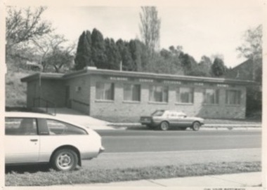 Kilmore Historical Society
Photograph, Kilmore Senior Citizens Club Rooms, 1980's
Is on the site of the Oriental Bank Corporation, but in a different building. 18cm x 12.5cm black and white photograph of the Senior Citizens Club Rooms at 7 Sydney Street Kilmore. Single story brick building with an access ramp on the south side of the building. Two cars are parked on the street, one on each side of the road. Printed on glossy standard photo stock. Possibly the same cite as the Oriental Bank Corporation. Stamped on the back of the item: John Squire Photography 633 Rathdowne Street N. Carlton - Phone 347 4922 NEG No. B4049-16banks -
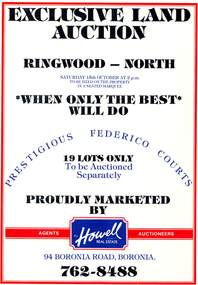 Ringwood and District Historical Society
Pamphlet, Land Auction Brochure - Federico Courts Estate, Ringwood North, Vic. Circa 1988
Bifold brochure advertising auction of 19 residential allotments on Saturday 15th October, (1988?). Brochure includes terms of sale, description of subdivision features and local facilities, with locality map. Subdivision includes Federico Court and Gilston Way, Ringwood North. Agents/Auctioneers - B.S. Howell Real Estate, 94 Boronia Road, Boronia, (Phone) 762 8488. -
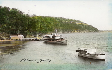 Lakes Entrance Historical Society
Postcard - Kalimna Jetty, 1925c
Hand coloured postcard showing the S S Gippsland leaving Kalimna Jetty. Jetty has two sheds on north end of jetty belonging to Kalimna Hotel. Navigation light on south end of jetty. M V Sagitassein lower right corner of photo. Jemmys Point in background with road cutting visible. Kalimna Lakes Entrance VictoriaKalimna Jettyships and shipping, waterways, jetties, boating -
University of Melbourne, Burnley Campus Archives
Plan, John S. Jenkins, Plan showing land required for Road Purposes from the temporary reservaton for Horticultural Gardens at Richmond, 1880
Plan drawn by hand on tracing paper by John S. Jenkins, Town Surveyor, Richmond. "The land required is coloured red & it is proposed to add the part of Swan Street coloured blue to the gardens." Plan depicts land required for road purposes from the temporary reservation for Horticultural Gardens at Richmond. (Also framed and glazed copy B92.0539.) Scanned on CD.john s. jenkins, gardens, richmond, hoticultural society of victoria -
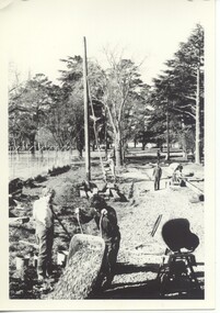 Ballarat Tramway Museum
Photograph - Black & White Photograph/s - set of 2, post June 1973
Yields information about the construction of the track and depot fan c 1972.Black and white photographs of the construction of the access track and depot fan at the new BTPS depot, involving he carting of gravel etc in wheel barrows. The poles have been positioned and the track extended over the level crossing indicating 1973, prior to the installation of one road. See - 1972 - 73 Annual Report page 3 for a list of dates.trams, tramways, depot, btps, construction -
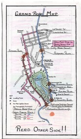 Melbourne Tram Museum
Map, Yarra Trams, "Grand Prix Map", 1996
Laminated sheet - to fit into a pocket - prepared by Greg Rodgers for Camberwell Depot drivers using Park St Kilda Grand Prix services - give details of automatic points, safety notes, details of St Kilda Road points, and what Camberwell drivers are to do. Greg Rodgers advised 5-11-2016, made for the first Grand Prix 1996.trams, tramways, camberwell depot, grand prix, map, public transport, park st st kilda -
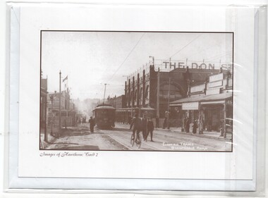 Melbourne Tram Museum
Photograph - Card with Envelope, Hawthorn Historical Society Inc, "Images of Hawthorn: Card 2", c2000
Card with a with an envelope and contained within a plastic envelope: Photo of a PMTT electric tram in Glenferrie Road, at the railway level crossing. Shows "The Don" department store and the level crossing catch point disc signal on the left hand side. Photo c1913. Has details of the photograph, source and the Hawthorn Historical Society on the rear of the card. One of a series of five cards.trams, tramways, hawthorn, glenferrie rd, level crossings, pmtt -
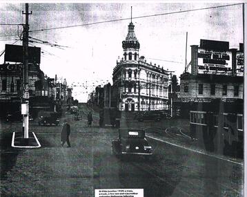 Melbourne Tram Museum
Photograph, St Kilda Junction, original 1939c
Laminated photograph - A3 size - St Kilda Junction looking south at the end of St Kilda Road - with the signal box - 1939. Shows the building, tram stop, hotels, motor vehicles. Has a W2 inbound on the right hand side of the photograph. Caption "St Kilda Junction 1939s. a tram, a truck, a few cars and a jaywalker epitomise Melbourne following"trams, tramways, st kilda junction, signal box, hotels, tram stops