Showing 2558 items
matching aerial
-
 4th/19th Prince of Wales's Light Horse Regiment Unit History Room
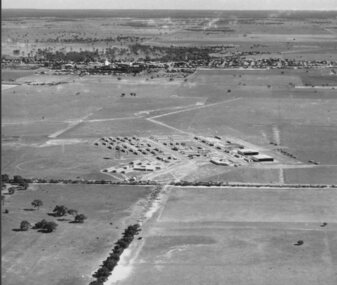
Aerial Photographs, Broadmeadows Victoria camp?, late 1940's
A set of 30 aerial photographs of what could be Broadmeadows Victoria camp. Some show the terrain, others the camp layout and others of a tank regiment formed up in Squadrons. The majority of the tanks appear to be General Grantsairial photos, tank camp, broadmeadows -
 Victoria Police Museum
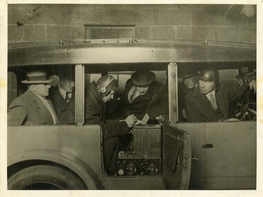
Photograph (police car), Kodak
Wireless Patrol Daimler, with wireless transmitter and receiver visible on back seat. Senior Constable Bill Black front left seat, Operator Cliff Allison, circa 1927. Wireless aerial in tubing attached to roof.police vehicles; transport; motor police branch; daimler car; wireless patrol; allison, cliff; black, bill -
Glenelg Shire Council Cultural Collection
Photograph - Photograph - View of port and facilities, c. 1974
Port of Portland Authority archives.Front: (no inscriptions) Back: (no inscriptions)port of portland archives, portland harbour -
 Ringwood and District Historical Society
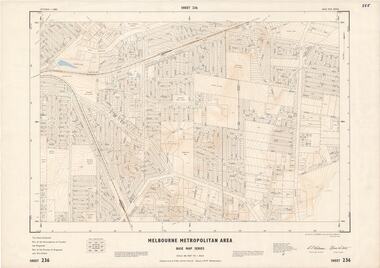
Map - Melbourne Metropolitan Area Base Map Series, Sheet 236 - Ringwood area, 1961
Map prepared by Dept of Lands and Survey and MMBW from State Aerial Survey June 1957 and Cadastral Survey information May 1961. This sheet comprises parts of the Municipalities of Croydon and Ringwood, and Parishes of Ringwood and Warrandyte.Scale: 400 feet to 1 inch. Contours at 5 feet vertical interval. By Authority: A.C. Brooks, Commonwealth Printer, Melbourne. -
Port Melbourne Historical & Preservation Society
Photograph - Aerial view of J Kitchen & Sons site, Port Melbourne, 1945
Large black and white aerial photo in narrow gold-coloured metal frame of J Kitchen & Sons Pty Ltd factory in foreground and Dunlop Tyres building in the background. Photo taken approx 1945 (copy)industry - manufacturing, built environment - industrial, j kitchen & sons pty ltd, pental products pty ltd, symex holdings ltd -
Port Melbourne Historical & Preservation Society
Photograph - Aerial view, Fishermans Bend, C D Pratt, 1945
Aerial photograph c1945 with the City of Melbourne in the foreground, showing Fishermen's Bend. Nissen huts are visible on the beach, as is one of the airfields. Fragment of photograph missing from bottom left hand corner and three significant tearsfishermans bend, war - world war ii, melbourne -
 Anglesea and District Historical Society
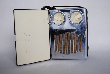
Tasma Radio 1199, Thom & Smith, Tasma, 1947
Battery operated radio which only operates when lid is open. There is a volume control and station selector. The inbuilt aerial is directional and the receiver should be oriented for maximum volume. This is a brown metallic radio with plastic strap.Operating instructions inside bottom cover (as described above). Front: "TASMA"tasma, radio, battery operated -
 Whitehorse Historical Society Inc.
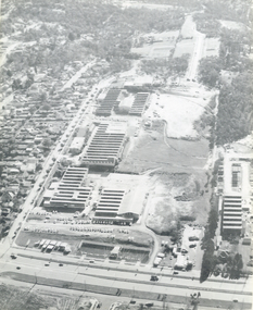
Photograph, Luke Group, 1959
K.G. Luke had a foundry in Queen's Parade, Melbourne which made badges and manufactured items for the Armed Forces during the First World War. He bought 40 acres of cherry orchard in Mitcham in 1952 from a Miss Cook, then went to England and attracted finance from Singer Brass Founders. The company became Luke and Singer. The three factories on site were Luke Manufacturing - stainless steel products and hospital equipment, Luke and Singer - a non-ferrous foundry producing components for industry such as nuts and cutlery, and Concentric Engineering - machinery components. Later the manufacture of refrigeration and air conditioning was added at the rear of the complex. A small aerial photograph and 2 A4 photocopies of the K.G.Luke Group of companies in 1959. The factory site is divided into three groups with Whitehorse Road situated at the bottom of the photo and Cook Road Mitcham to the left. Notes at ND6245luke manufacturing, k.g.luke group, luke and singer, concentric engineering, wheatland, vic, manufacturing industry, foundries, engineering industries -
 Ballarat Tramway Museum
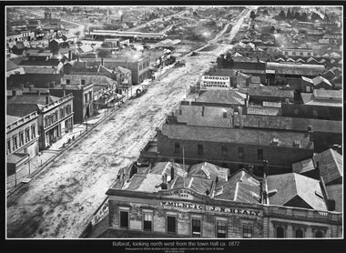
Photograph - Black & White copy, William Bardell, "Ballarat looking north west from the Town Hall ca 1872"
Original photograph by William Bardwell, with the original image held by the State Library of Victoria. Edited by Richard Conn. Purchased by the Museum.Provides information about the appearance of Armstrong St from the Town Hall. Shows the topography of the area, along with many buildings, including W Milne & Cp and J N Healy in the Hall of Commerce and Doig & Co, Plumbers and Gasfitters.Black & White copy photograph aerial view A4 size, titled ""Ballarat looking north west from the Town Hall ca 1872" looking along Armstrong St. Original photo by William Bardwell.ballarat, armstrong st, w milne & co, doig&co, j n healy -
City of Kingston
Photograph - Black and white, 20 December 1945
This photograph depicts a section of Cheltenham with a mix of housing and market gardens. The visible market gardens, farms and paddocks have gradually been sub-divided into housing, commercial and industrial estates. A large part of Cheltenham was originally established as a rural market gardening community. The railway line and station brought urban development to the area and the gradual subdivision of farmland and large land holdings for the development of housing. Aerial photograph dated 1945 of the Cheltenham area in the City of Kingston. Sydney Street (bottom left); Sinclair Street (top left); Weymar Street area off Wilson Street, Charles Street (botton right).White print VIC-170; 57197; RUN5; PROJ.No.5; MELB.METROP AREA Lens information [indecipherable] Small photograph: clockface Black ink: 57197cheltenham, market gardens, urbanisation -
 Port Melbourne Historical & Preservation Society
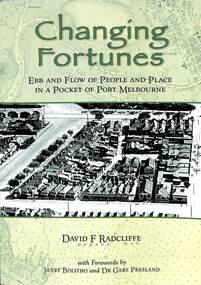
Book, David Radcliffe, Changing Fortunes, March 2021
"Ebb and flow of people and places in a pocket of Port Melbourne " Also contains many references throughout the book to PMHPS collectionWhat it was like to live around the upper reaches of the former Sandridge Lagoon from pre settlement times up until the 1940s. It locates the history of many families who built their dreams on a pocket of reclaimed land in Port Melbourne in the 1880s "Ebb and flow of people and places in a pocket of Port Melbourne" Soft cover book. Green in colour with images of aerial photo of port Melbourne on front and back covers. On back page "once as it was - Boon Wurrong Foundation" yalukit willam, boon-warrung, george beazley, anne chaffey, swallow & ariell ltd, port melbourne town hall, sandridge lagoon, business and traders - milkbars, spring street, esplanade east, built environment - commercial, built environment - domestic, domestic life -
 Lakes Entrance Historical Society
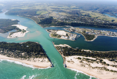
Photograph - Lakes Entrance, 2000
Colour photograph of aerial view of the entrance at Lakes Entrance, shows part of Rigby Island, Bullock Island, North Arm, Cunninghame Arm and buildup of sand on ocean shores of sand hummocks. Lakes Entrance Victoria waterways, township, topography -
 Ballaarat Mechanics' Institute (BMI Ballarat)
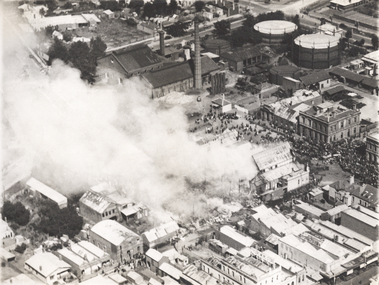
Coliseum Ballarat aerial burning
This photograph is from the Max Harris Collection held by the Ballaraat Mechanics' Institute. Please contact BMI for all print and usage inquiries.ballarat, coliseum, aerial, burning, grenville st, little bridge st -
 Ballarat Heritage Services
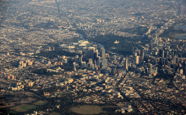
Digital Photograph, L.J. Gervasoni, Melbourne CBD on approach Melbourne Airport, 2016, 2016
Colour photorgraph showing the Melbourne Business District from the air.aerial, melbourne, cbd, domain, cityscape, parklands -
 Ballarat Heritage Services
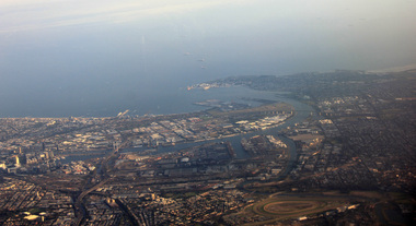
Digital Photograph, L.J. Gervasoni, Melbourne CBD on approach Melbourne Airport, 2016, 2016
Digital Image showing the Melnourne Business District from the air.aerial, melbourne, mouth, yarra river, west gate bridge, inner west -
 National Vietnam Veterans Museum (NVVM)
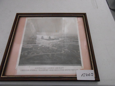
Photograph, Two RAAF Caribou over Vietnam
A black and white aerial photo of two Australian Caribou's aircrafts. The aircrafts were used in Vietnam for the transportation of soldiers to and from the conflict and was used for general transport of equipment. Photograph of two RAAF Caribou Aircraft over Vietnamcaribou, photograph, south vietnam -
Bendigo Historical Society Inc.
Photograph - FORTUNA COLLECTION: AERIAL VIEW OF BENDIGO 1963
Black and white photograph, aerial view of Bendigo 1963, Fortuna Villa in foreground. On bottom of photograph ' Fortuna, an aerial view of Bendigo Circa 1963' Fortuna Villa in foregound of image, showing very clear detail of grounds. Image has labels of following sites: Lansell's 222 mine Lazarus mine site Central Red, White and Bluye mine site, Old Chum mine site New Chum and Victoria mine site West End Hall Mount Alvernia BCV8 QEO -
City of Kingston
Photograph - Black and white, 17 January 1951
Moorabbin, Cheltenham and Highett are suburbs in the City of Kingston with a diverse mix of development and zoning. This 1954 image shows the market gardens, farms and paddocks of the Moorabbin and Cheltenham area. which have gradually been sub-divided into The Highett Gas Works is visible and Cheltenham Park and Victoria Golf Club.The suburbs of Cheltenham and Moorabbin were originally developed with extensive market gardens. Over time the district has been transformed with the farms and paddocks replaced by housing, factories and shopping centres. The Highett Gas Works on the Nepean Highway was a significant feature of the landscape and has now been demolished. and the site has undergone remediation.Aerial photograph of Cheltenham, Moorabbin and Highett within the City of Kingston. The area depicted in this 1951 aerial view includes Wickham Road, Highett (bottom right), Keys Road, Moorabbin (bottom left), Centre Dandenong Road Cheltenham (top left), Park Road, Cheltenham (top right), Nepean Highway (left section), Graham Road and Middleton Street, Highett (bottom right). Cheltenham Park and Victoria Golf Club are visible. Nepean Highway and the Frankston railway line run centrally through the image.White type: 1416-37 538 RUN239 LENS 5312" MELBOURNE METROPOLITAN 12150 17-1-51 ↆ M539 Black pencil: N [arrow]cheltenham, highett, highett gas works, market gardens -
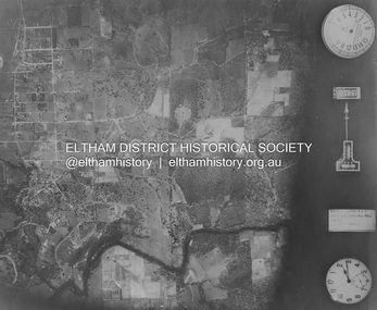
 Eltham District Historical Society Inc
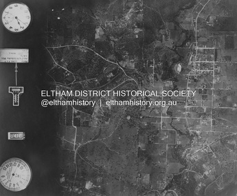
Photograph - Aerial Photograph, Landata, Eltham and Montmorency, Nov. 1931
Centred over present-day Belmont Reserve, Montmorency Historic Aerial Imagery Source: Landata.vic.gov.au Aerial Photo Details: Project No :1931 Project : MALDON PRISON Run : 19 Frame : 3130 Date : 11/1931 Film Type : B/W Camera : F8 Flying Height : 11000 Scale : 18860 Film Number : 60 GDA2020 : 37°43'13"S, 145°07'54"E MGA2020 : 335330, 5823576 (55) Melways : 21 F6 (ed. 42)aerial photo, eltham, neil webster collection, belmont reserve, montmorency, rattray road -
 Eltham District Historical Society Inc
Photograph - Aerial Photograph, Landata, Eltham, Nov. 1931
Centred over Mount Pleasant Road and Kent Hughes Road, Eltham Historic Aerial Imagery Source: Landata.vic.gov.au Aerial Photo Details: Project No :1931 Project : MALDON PRISON Run : 20 Frame : 3137 Date : 11/1931 Film Type : B/W Camera : F8 Flying Height : 11000 Scale : 18860 Film Number : 60 GDA2020 : 37°43'37"S, 145°09'26"E MGA2020 : 337606, 5822892 (55) Melways : 22 A8 (ed. 42) aerial photo, eltham, neil webster collection, kent hughes road, mount pleasant road -
 Nhill Aviation Heritage Centre
Black and White photograph, Possibly Dept of Defence photograph, Nhill RAAF Base
The Nhill RAAF Base was built during WWII as part of the Empire Air Training Scheme (EATS Scheme)This is believed to be the first aerial photo taken of the RAAF Base. Aerial photograph of the Nhill RAAF base thought to be taken late 1941 or early 1942. Notice that only two of five Bellman Hangers have been built and trees have not been planted along the driveway into the base.raaf, 1941, base -
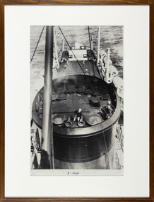 Mission to Seafarers Victoria
Photograph - Reproduction, Black and white, Mission to Seafarers Victoria, 3" Deep, c. 2009
This photograph is part of reproductions of images from the MTS archive collection. Framed and mounted black and white reproduction of photograph from the archive depicting an aerial view of the funnel of a ship. A crew member is checking something on the funnel. In the background we can see 4 men playing tennis on the deck3" Deepmission to seafarers, mission to seamen, flinders street, melbourne, seafarers, seamen, padre oliver, crew, ships, seafaring life, sailors, funnel, ship, tennis, early origins, 2016, life onboard -
 Greensborough Historical Society
Book, Typical Homes that would be constructed by Mitchell Trading Pty Ltd, 1960_
An early advertising brochure for prospective homeowners to choose the style of home they would like built. House and land packages were available in the areas of Bundoora surrounding the Loyola and Parade College sites, which were monasteries in the 1960s. The aerial photographs show the open nature of the landscape from Bundoora across to Greensborough and Watsonia in the 1960s. Book of black and white photographs bound in brown card cover. Contains 14 photos of houses and shops and 14 aerial photos of Bundoora including the Loyola and Parade College areas. Includes notes from Gary Partington.In pencil inside front cover: 29/1/1960.houses, bundoora, greensborough, watsonia, loyola college, parade college, mitchell trading, aerial photography -
Glenelg Shire Council Cultural Collection
Programme - Souvenir Program - 1981 Portland, Victoria, c. 1981
1981 Portland 'Back-to' Souvenir Program. Glossy card covers, coloured image 'landing of the Hentys' (Photo courtesy of RACV) on front cover; aerial photo of the harbour (photo courtesy of Portland Harbour Trust) on back cover -
Glenelg Shire Council Cultural Collection
Newspaper - Portland Observer Supplement, Nov-02
Bower Bird MuseumPortland Observer supplement, November 2002, re Port of Portland 50 year anniversary coloured glossy covers, aerial shot of Port on front, Nuns Beach on back. 8 page newspaper insert, history of Port.newspaper, special edition, portland observer -
Glenelg Shire Council Cultural Collection
Photograph - Photograph - aerial view of Portland, c. 1954
Black and white aerial photograph of coastline around Portland. Black border, scale all sides, 5 rows of 3 't' at regular intervals.Mostly ocean, strip of land down right hand edge and across bottom.Front: '607 - 55 ' - handwritten, white, border 'RUN 7 'PORTLAND', printed, white, borderaerial photography, central portland, portland harbour, south west coastline -
Glenelg Shire Council Cultural Collection
Photograph - Photograph - Aerial view of coastline around Portland, Victoria, c. 1954
Black and white aerial photograph of coastline around Portland. Black border, scale all sides, 5 rows of 3 't' at regular intervals. Top half is ocean, bottom half is ? beach; sand dunes, cliffs.Front: '607 - 61 ' - handwritten, white, border 'RUN 7 PORTLAND', printed, white, border -
Glenelg Shire Council Cultural Collection
Photograph - Photograph - aerial view of Portland, c. 1954
Black and white aerial photograph of coastline around Portland. Black border, scale all sides, 5 rows of 3 't' at regular intervals. Further along to left, almost straight 60/40 ocean to land.Front: '784 - 152' - handwritten, white, border 'RUN 7 A PORTLAND', printed, white, borderaerial photography, central portland, portland harbour, south west coastline -
Glenelg Shire Council Cultural Collection
Photograph - Photograph - aerial view of Portland, c. 1954
Black and white aerial photograph of coastline around Portland. Black border, scale all sides, 5 rows of 3 't' at regular intervals. Fifty percent ocean, 50 percent land. See 'Other Information'Front: '820 -49' - handwritten, white, lower border 'RUN 6' 'PORTLAND', printed, white, lower borderaerial photography, central portland, portland harbour, south west coastline -
Glenelg Shire Council Cultural Collection
Photograph - Photograph - aerial view of Portland, c. 1954
Black and white aerial photograph of coastline around Portland. Black border, scale all sides, 5 rows of 3 't' at regular intervals. Three quarters ocean, one quarter land. See Other InformationFront: '820 -48' - handwritten, white, border 'RUN 6' 'PORTLAND', printed, white, borderaerial photography, central portland, portland harbour, south west coastline