Showing 11522 items matching "maps"
-
 Orbost & District Historical Society
map/poster, Victorian Government Printer, 22.4.1926
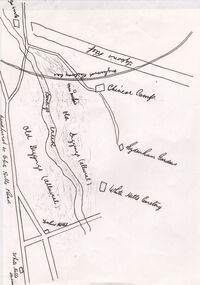
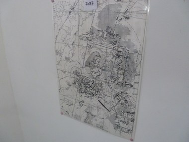
The Department of Crown Lands and Survey was originally established in 1857 as part of the Board of Land and Works. In 1964 it ceased to be controlled by the Board. The Department functioned for almost twenty more years before being combined with other Ministries to form the Department of Conservation, Forests and Land. It was responsible for the management of the State's Crown land and pastoral estates. This map was used by Don Mehlert after 1928. The VERMIN AND NOXIOUS WEEDS ACT 1928 was an Act to consolidate the Law relating relating to Vermin and Noxious Weeds. E. J. E. G. Pemberton who published this poster was Superintendent of Field Staff, Dept. of Lands and Survey. This map and posters are significant records of early settlement history in Murrangower, between Cabbage Tree and Orbost,A paper map of Murrangower showing settlement subdivisions. This is glued onto the back of four overlapping cloth poster of "Notices of Vermin Destruction". All print is black."DON MEHLERT" in black pen. Pike's block shaded in blue. School site marked in blue pencil. on poster "MURRANGOWAR" along side.map-murrangower poster-vermin-and-noxious-weeds murrangower-settlement -
 Melbourne Tram Museum
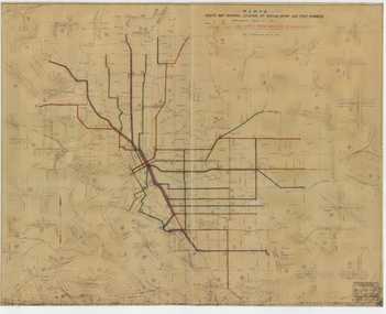
Drawing, Melbourne & Metropolitan Tramways Board (MMTB), "Route Map showing location of special work and pole numbers" "All night tram routes in colours", late 1941
Map of the system shown at two inches = 1 mile. Drawing No. P5799. Shows crossovers, track layouts at junctions, signal cabins roads, railways, and stations. Originally signed by Perway Engineer - 20/12/1940, though originally drawn in 1922. Has been marked up in colour pencil to show the all-night routes and the individual services. The plan shows the lines to Maribyrnong Munitions works along Cordite Ave and Wests Road and the track from Moonee Ponds to Union Road, opened in July 1941, but not the extension to Essendon Airport built in 1942.Demonstrates a detail drawing of Melbourne tramways, junctions and pole numbers.Drawings - dyeline cloth-backed print - titled - "Route Map showing the location of special work and pole numbers" and subtitled - "All night tram routes in colours". trams, tramways, mmtb, trackwork, tramways, junction, map, world war 2, night trams -
 Glenelg Shire Council Cultural Collection
Booklet - Portland Brochure, 1970s
Portland brochure including advertising, town map and district map.portland, tourism, economy, advertising -
 Lilydale RSL Sub Branch
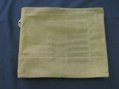
map - WWII Australian map, C. G. Hartley & Co 1943, 1943
WWII Australian Issue Map Case/ Plotting Board - with map -
 Greensborough Historical Society
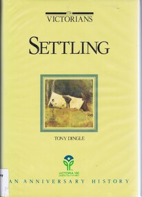
Book, Settling: The Victorians. By Tony Dingle, 1984_
Part 2 of a 3-part series deals with land use from Aboriginal land use to European settlement.Published to commemorate the 150th anniversary of European settlement in Victoria.Hard cover. 274 pages, illus., maps, end maps.victoria land use, victoria history, victoria social conditions, tony dingle -
 Bendigo Historical Society Inc.
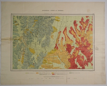
Map - COUNTY OF GLADSTONE, November 1910
Map: County of Gladstone, Geological survey of Victoria. Geological mapmap, gladstone, geological, county of gladstone, geological map -
 Flagstaff Hill Maritime Museum and Village
Drawing - Pastel Picture, W.R. Angus (Dr. William Roy Angus), 1925
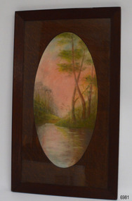
This large pastel drawing was created by Dr W.R. Angus in 1925, the year after he graduated as a doctor in South Australia. In 1926 Dr Angus was appointed as Medical Assistant to Dr Thomas Francis Ryan, in Nhill, Victoria, where he extended his experiences in radiology and pharmacy. Eventually, in 1939, he and his wife Gladys moved to Warrnambool, Victoria, with their children. The drawing is part of the W.R. Angus Collection, which includes another of the doctor’s pastel drawings and a box of used pastels. The picture was framed by W.H. Rogers & Co. of North Terrace, Adelaide. The business also framed maps and plans. This pastel drawing is locally significant for being the work of Warrnambool doctor, W.R. Angus. It is part of the W.R. Angus Collection, which is significant for still being located at the site it is connected with, Doctor Angus being the last Port Medical Officer in Warrnambool. The collection of medical instruments and other equipment is culturally significant, being a historical example of medicine, administration, household equipment and clothing from late 19th to mid-20th century. Dr Angus assisted Dr Tom Ryan, a pioneer in the use of X-rays and in ocular surgery. The collection includes Army objects, which are examples of items issued to Doctors and Surgeons in the Medical Services of the Australian Army in World War 2. It also includes household items used by Dr Angus and his family from the 1920s in various locations including Warrnambool, together creating an understanding of the furnishing of an early to mid-20th century home.Pastel drawing behind glass in a rectangular wooden frame with an unusual oval wooden matt. The subject is a scene with a pink-tinted sky reflected in a river running between the foot of two hills with trees. The picture was created and signed by W R Angus in 1925. The back is covered in brown paper and has a mounting wire. Inscriptions are on the picture and the back. A remnant of the framer’s label is attached. The picture is part of the W.R. Angus Collection. Signature and date; “W.R.A. / 1925” Printed on label remnant; “—Rogers & Co. / - ORIA STREET / - way Station, North Terrace / “THE CORRECT FRAMERS” / -lise in Map and Plan Mounting / PHONE 5437”flagstaff hill, warrnambool, maritime village, maritime museum, shipwreck coast, great ocean road, drawing, pastel drawing, pastel drawing by w.r. angus 1925, rogers & co., w.h. rogers & co., correct framers, w.r. angus collection -
 The 5th/6th Battalion Royal Victoria Regiment Historical Collection
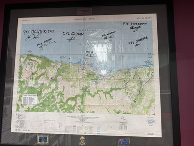
Map - Honiara Map, Honiara West Special used by members of 5/6
Honiara West Special signed by 7 members of 5/6 RVR who were deployed on Operation AnodeThe Map is framed in the glass frame withe the Operation Anode patch, Australian Flag and 5/6 unit symbol displayed below the Map. It has been signed by 7 members of 5/6, each member's PMKey is also displayed on the Map -
Bendigo Historical Society Inc.
Map - HUNTLY, SHEET 4, 29/03/1876
Map: Parish of Huntly, Sheet 4, County of Bendigo. Hand Draughted Parish plan. Originally in Map Cupboard. Relocated to Map Drawer 5 on 22.9.22. Too long for the map cupboard.map, bendigo, parish plan, huntly -
 Federation University Historical Collection
Document - Document - Information, VIOSH: Background Paper for Stakeholders Workshop, Friday 2 June 1994
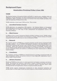
Victorian Institute of Occupational Safety and Health (VIOSH) Australia is the Asia-Pacific centre for teaching and research in occupational health and safety (OHS) and is known as one of Australia's leaders on the field. VIOSH has a global reputation for its innovative approach within the field of OHS management. VIOSH had its first intake of students in 1979. At that time the Institution was known as the Ballarat College of Advanced Education. In 1990 it became known as Ballarat University College, then in 1994 as University of Ballarat. It was 2014 that it became Federation University. VIOSH Australia students are safety managers, senior advisors and experienced OHS professionals. They come from all over Australia and industry. Students are taught active research and enquiry; rather than textbook learning and a one-size fits all approach. VIOSH accepts people into the Graduate Diploma of Occupational Hazard Management who have no undergraduate degree - on the basis of extensive work experience and knowledge. The Background Paper prepared for a meeting to be held on Friday 2 May 1994. It is a Stakeholders Workshop. Information on VIOSH over the years provided. The range of OHS activities include: 1. Accredited Tertiary Courses 2. Short Courses 3. Research 4. Consultancy 5. Advisory Function 6. Information Resources The Graduate Diploma in OHM started in 1979 and was the first Occupational Health and Safety tertiary course in Australia. Since then it has continued to attract students at a national level even though similar courses were offered elsewhere. The map on Page 2 shows the extent of enrolments. The Courses Review Process is outlined and VIOSH is now able to define its own procedures and processes for reviewing its post-graduate programs.This is being managed by a small internal project management team. The "new" programs to commence in 1996.Four A4 pages, typed. Page 2 -map of Australiaviosh, victorian institute of occupational safety and health, ballarat college of advanced education, graduate diploma in ohm, stakeholders workshop, accredited tertiary courses, short courses, research, consultancy, advisory function, information resources, course review process -
Creswick Campus Historical Collection - University of Melbourne
Map, 1923
Includes detail of Plantation layout and plantings at the time and later plantings (1930's) in pencil.Map -
 Creswick Campus Historical Collection - University of Melbourne
Map - Campus map, framed, 1969-1974
VSF Fire protection Plan. Framed. Prepared in interval between construction of Science Block and commencement of Certificate Courses (1969-1974) (Bob Orr)Mapfire protection, victorian school of forestry, creswick -
 Magnet Galleries Melbourne Inc
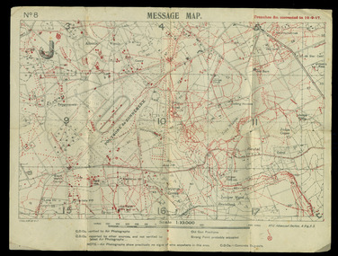
map showing trenches &c, red cliffs00168.tif
mapww1, world war 1, map, trenches -
 Magnet Galleries Melbourne Inc
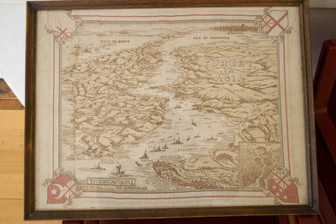
map of gallipoli / turkey, redcliffs_dsf6241.tif
mapww1, world war 1, gallipoli, turkey, map -
 Bendigo Military Museum
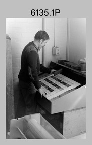
Photograph - Print Troop – Lithographic Squadron – Army Survey Regiment, Fortuna, Bendigo
This collection of 23 photos was most likely taken in Lithographic Squadron, Army Survey Regiment, Fortuna, Bendigo, in 1988. In photos .1P and .2P the technician is preparing a Chromalin map proof for supporting information that would be printed on the reverse side of a topographic map. This map was commonly referred to as a ‘snack’ map, with photos of edible indigenous plants and descriptions endemic to that region printed on the reverse side to assist soldiers living off the land in survival situations. The authoritative information was provided by Major Leslie James (Les) Hiddins aka ‘the Bush Tucker Man’ He is a retired Australian Army soldier and war veteran, who is best known for his love and knowledge of the Australian bush. See item 6190.6P for more information on the Chomalin proof production process. In the remaining photos, Print Troop’s technicians were most likely operating the Komoni, Planeta or Ultra-MAN-III offset printing presses, as well as working in the map despatch dock. Although these photos are not annotated most personnel are positively identified. This is a set of 23 photographs of Print Troop personnel and equipment from Lithographic Squadron at the Army Survey Regiment, Fortuna, Bendigo, 1988. The photographs were on 35mm negative film and were scanned at 96 dpi. They are part of the Army Survey Regiment’s Collection. .1) - Photo, black & white, 1988, Chromalin Proof laminating, Terry King. .2) - Photo, black & white, 1988, Chromalin Proof laminating, Terry King. .3) to .6) - Photo, black & white, 1988, Ultra-MAN-III Printing Press, Colin Yeats. .7) - Photo, black & white, 1988, Ultra-MAN-III Printing Press, L to R: Greg Rowe, SPR Mark ‘Dogs’ Doherty. .8) - Photo, black & white, 1988, Ultra-MAN-III Printing Press, SPR Mark ‘Dogs’ Doherty. .9) to .10) - Photo, black & white, 1988, Ultra-MAN-III Printing Press, John Bateman. .11) - Photo, black & white, 1988, Ultra-MAN-III Printing Press. .12) - Photo, black & white, 1988, Map laminator? L to R: SGT Dale Hudson, SGT Gary Kerr. .13) - Photo, black & white, 1988, Newkoni Komori Printing Press, Peter Hamilton. .14) to .17) - Photo, black & white, 1988, Original Heidelberg Printing Press, Peter Hamilton. .18) to .19) - Photo, black & white, 1988, Map Despatch area, SPR Steve Wright. .20) - Photo, black & white, 1988, Map Despatch area, L to R: unidentified, SGT Gary Kerr. .21) - Photo, black & white, 1988, Printing Presses - foreground: Ultra-MAN-III (x2), centre: Newkoni Komori and background: Planeta Polygraph. .22) - Photo, black & white, 1988, Ultra-MAN-III Printing Presses (x2). .23) - Photo, black & white, 1988, L to R: Daryl South, Mark McCulloch.No personnel are identifiedroyal australian survey corps, rasvy, army survey regiment, army svy regt, fortuna, asr, litho, printing -
Bendigo Historical Society Inc.
Map - BENDIGO SHEET 3
Map: copy of Parish plan, canvas backed. Map shows Bendigo city streets. ( number 126 in Map Cupboard 1)map, bendigo, city streets, bendigo, city streets -
 Melbourne Tram Museum
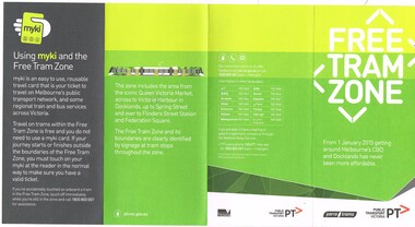
Pamphlet, Public Transport Victoria (PTV), 'Free Tram Zone", Dec. 2014
... Maps ...Pamphlet - DL size, 4 fold, printed on off white paper, titled "Free Tram Zone", providing information about the introduction of the free tram zone in the Melbourne CBD and a map. Applicable from 1/1/2015. Has contact details, Yarra Trams, PTV logos and Victorian Government logo on the rear. Notes the use of Myki cards. 2 copies held.trams, tramways, free tram, yarra trams, maps, melbourne, myki -
 Ringwood and District Historical Society
Map, Department of Mines, Plan of area applied for under the mining leases regulations in the township of Ringwood between Maroondah Highway and Mt. Dandenong Road. Mining District of Castlemaine, County of Mornington, Parish of Ringwood T Area 58(A) 2 (R)15(P) Acres, Roods, Perches. 1934, 20-Feb-34
Map of the township of Ringwood with subdivisions between Maroondah Highway and Mt. Dandenong Road. the area applied for on lease No.8210 by E.G.Browne.Mining District of Castlemaine, County of Mornington, Parish of Ringwood T Area 58(A) 2 (R)15(P) Acres, Roods, Perches.Buff coloured sheet foolscap with black printing showing map of the township of Ringwood between Maroondah Highway and Mt. Dandenong Road. Mining District of Castlemaine, County of Mornington, Parish of Ringwood T Area 58(A) 2 (R)15(P) Acres, Roods, Perches +Additional Keywords: Browne E.G. -
 Bacchus Marsh & District Historical Society
Map, Mooradoranook Parish Map, County of Grant
A single page paper map showing the map for the Parish of Mooradanook in the County of Grant. Cadastral map showing land ownership. The map is pasted into a bound volume containing 76 maps or plans in total. High resolution digital image stored on BMDHS computer network. Photo lithographed at the Department of Lands and Survey Melbourne by T. F. McGauran, 27.11.06mooradoranook parish maps, mooradoranook parish plan, bacchus marsh region parish plans -
 Bacchus Marsh & District Historical Society
Map, Mouyong Parish Map, County of Grant
A single page paper map showing the map for the Parish of Mouyong in the County of Grant. Cadastral map showing land ownership. The map is pasted into a bound volume containing 76 maps or plans in total. High resolution digital image stored on BMDHS computer network. Photo lithographed at the Department of Lands and Survey Melbourne by T. F. McGauran, 9. 4. 07mouyong parish plan, mouyong parish maps, bacchus marsh region parish plans -
 Ringwood and District Historical Society
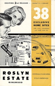
Flyer, Land Sale Brochure - Roslyn Estate, Ringwood, Vic. - circa 1960s
Land sale advertisement for 2nd release of residential sites with area map, layout of the estate, terms of sale, and summary of local facilities and services.Subdivision includes Daisy Street, Vale Street, Joan Court, Christine Court, and Westmore Drive. (Agent) Heathmont Estate Agency, 103 Canterbury Road, Heathmont. (Phone) WU7808-9. Brochure also includes map with streets marked as "Sold" - Reilly Street, Adrian Court, Daisy Street, Jarma Road, Joel Court, and Ross Court, with comment that "all home sites in the first release have already been sold, and most built on." -
 Warrnambool and District Historical Society Inc.
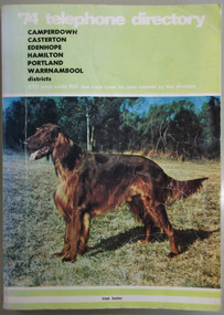
Book, Telephone Diretory 1974, 1974
The telephone directory contains both White Pages and Pink Pages listings. The White Pages listings are in alphabetical order of names for the entire 055 district. This directory is of some importance as it lists the names and addresses of people and businesses with telephones in 1974 in the 055 area code. Most of the listings of the smaller towns give the names of the homes and properties. So this is a very useful tool for research purposes.This is a soft cover booklet with a green cover and a colour photograph of an Irish Setter dog on the front cover and a map of the telephone area on the back cover. Front cover – ’74 Telephone Directory, Camperdown, Casterton, Edenhope, Hamilton, Portland, Warrnambool districts. STD area code 055. See back cover for area covered by this directory Spine – Camperdown, Casterton, Edenhope, Hamilton, Portland, Warrnambool districts. See the pink pages for business & trade listings. V1- 1974 Back Cover – Country directory areas. The area covered by this Directory is the coloured portion of this map. See the pink pages for business and trade listings. warrnambool 1974, warrnambool telephone directory 1974, 055 telephone directory -
 Warrnambool RSL Sub Branch
Map - 1947 Minesweeping map, North Queensland minesweeping map, unknown
1947 an after-effect od WW2Laminated A3 Map plus A4 map in pocket (copies of original)shows location of minefields to be cleared in 1947 and names of minesweeping ships!947 ran history -
 City of Moorabbin Historical Society (Operating the Box Cottage Museum)
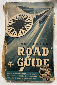
Book, Herald Touring Club (Victoria), The Herald road guide, 1950s
Map of southeastern Australia, Adelaide to Brisbane, showing roads and distances, with chief detail about Victoria. Includes strip maps, itinerary guides, and index. Issued by the Herald Touring Club, with new district and city maps surveyed by the Club.1 atlas (224 p.), 1 folded map : ill., maps ; non-fictionMap of southeastern Australia, Adelaide to Brisbane, showing roads and distances, with chief detail about Victoria. Includes strip maps, itinerary guides, and index. Issued by the Herald Touring Club, with new district and city maps surveyed by the Club.automobile travel, road maps, herald touring club -
Bendigo Historical Society Inc.
Map - CAMPBELL COLLECTION: BENDIGO AND DISTRICT MAPS
Map. Sedgwick. Continuation of 10104.13. (number 360 in map cupboard 1)map, bendigo, agricultural lands -
 Bendigo Historical Society Inc.
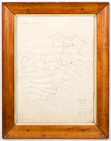
Document - CONSTABLE RYAN COLLECTION: HAND DRAWN MAP OF AREA OF CONSTABLE RYAN DISAPPEARANCE
An hand drawn map of the area of constable Ryan disappearance. The map is not to scale.document -
Bendigo Historical Society Inc.
Map - NERRING SHEET 2, 21/12/1894
Map[: Nerring sheet 2 ( number 187 in Map Cupboard 1)map, bendigo, parish plan, nerring -
Bendigo Historical Society Inc.
Map - LYELL, 4/06/1873
Map: Lyell. Parish plan (number 278 in map cupboard 1)map, bendigo, parish plan, lyell -
 National Vietnam Veterans Museum (NVVM)
Map, Map of Area Surround Luscombe Airfield
Laminated map of military installations surrounding Luscombe Airfield. No identification of the map.luscombe field -
 National Vietnam Veterans Museum (NVVM)
Map
A details map detailing Nui Dat. This map is a Special Edition 2map, nui dat