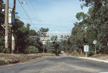
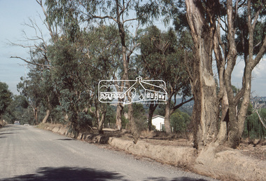
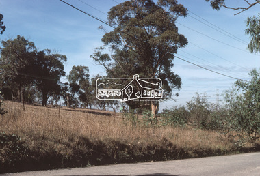
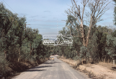
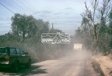
Showing 25603 items matching "plenty-township-estate"
-
 Ringwood and District Historical Society
Booklet, Service Booklet for the funeral of Dulcie May Mitchell (nee Campbell) who worked for Carter Real Estate for 20 years
Dulcie worked for Carter Real Estate in Ringwood for 20 years. This booklet was in the Richard carter Collection.Bifold booklet with insert and many Photographs accompanied by text about Dukcie's life. -
 Ringwood and District Historical Society
Photograph, Kubis Estate, North Ringwood in April 1978. View of the lake site looking east. The wall was where the track bends. The rope tree was on the hillside beyond the track bend
E548 N35 This photo was taken from almost the same spot as the 1976 one. Part of a 51-photo record of the development of the "Kubis" Estate, Ringwood North, including road works to Debbie Place, Kubis Drive, Werac Drive, Manuelo Drive, Iluka Place and Glenvale Road. From the Jack Lundy Clarke collection. -
 Lorne Historical Society
Map, F W Niven Lithos, The Mountjoy Lorne Estate, 1889
In 1888 a company was formed to acquire and subdivide the land of the Mountjoy Brothers. The land totaled 197 acres and included Erskine House. The land colored red was that of the Mountjoys. The subdivision map was printed in 1889A paper map of the Mountjoy Estate Lorne , showing allotments, with their owners, and naming land use. It has four black and white line drawings , Erskine House, Mountain View’s, the Rapids, Erskine House sea view and Erskine Falls. The map is largely black and white with red and blue colouring. The map is mstuck to brown paper. lorne, subdivision map, erskine house, mountjoy brothers, -
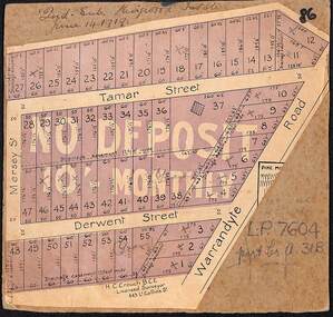 Ringwood and District Historical Society
Map, The Ringwood Estate - Second Sub-Division, Ringwood, Victoria - 1919
Three cardboard-backed copies of map clipped from land sale auction brochure. Subdivision includes Warrandyte Road, Tamar Street, Mersey Street and Derwent Street.H.C. Crouch BCE, Licensed Surveyor, 443 LtCollins Street, Melbourne. Handwritten real estate notations in margins and on some allotments include sales information and reference LP7604 - Part of Crown Allotment 31B. Auction date June 14th, 1919. -
 Greensborough Historical Society
Newspaper Clipping, Diamond Valley Leader, Agent named nation's rising star in real estate, 02/08/2017
A promising local real estate agent has snapped up one of the industry's most coveted titles.News article 1 page, black text.flannagan, peressini and shaw, real estate business awards, greensborough, ben flannagan -
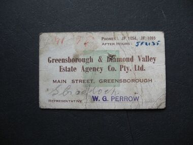 Greensborough Historical Society
Business card - Digital Image, Greensborough And Diamond Valley Estate Agency, 1960, 1960s
Digital image of business card for Greensborough And Diamond Valley Estate Agency, Main Street, Greensborough 1960s.Part of a collection of miscellaneous historical images with a connection to the local area.Digital image of business card.Various notes and representative's name.main street greensborough, greensborough and diamond valley estate agency -
 Eltham District Historical Society Inc
Negative - Photograph, View towards Main Road, Research from Maroondah Aqueduct Trail showing mudbrick manufacture, Research Industrial Estate, 1991
Eltham Little Theatre in centre distance and new housing estate development off Reynolds Road in distanceRoll of 35mm colour negative film, 9 strips Colour print 10 x 15 cmFuji HG 200 CA-1eltham little theatre, houses, main road, maroondah aqueduct, maroondah aqueduct trail, mudbrick, mudbrick construction, research (vic.), research industrial estate, reynolds road -
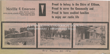 Eltham District Historical Society Inc
Document - Property Binder, 101 Main Road, Lower Plenty, 1971
Newspaper advertisement: Leader Associated Newspapers, Eltham Centenary Supplement, March 30, 1971 Neville F. Emerson, Real Estate Agentmain road, property, businesses, neville f. emerson, real estate agent, lower plenty village, lower plenty -
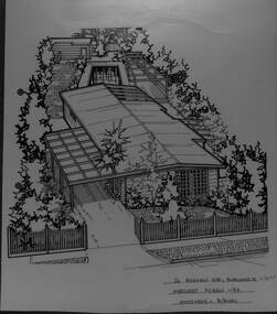
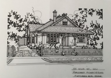 Kew Historical Society Inc
Drawing - Property Illustration, Margaret Picken, 85 Wills Street, Kew, 2002
After training as a Cartographic Draftsman within the mining industry, I worked as a property illustrator for real estate firms in the eastern suburbs of Melbourne for 22 years from 1983. I initially photographed houses with a Polaroid camera and made a 'thumbnail' sketch while there. The photos were used to scale off a sketch in pencil and then that sketch was overlaid with drafting film and the 'pen and ink' completed. The pens I used were the Rotring ‘Rapidigraph’ drafting pens. The ink was also made by Rotring (German).The film was ‘Rapidraw’, polyester drafting film, double matte. It takes a very fine line and doesn’t bleed. As well as house sketches, there were often floor plans and site plans ordered. Aerial sketches were ordered when the property needed an overall view. (Margaret Picken, 2020)This drawing is one of a series created by Margaret Picken for a number of real estate agents in Melbourne between 1983 and 2005. Each work is signed and dated by the artist.Gift of Margaret Picken, 2020Pen and ink architectural drawing on drafting film of 85 Wills Street, Kew by Margaret Picken.85 WILLS ST., KEW / MARGARET PICKEN ©2002 / FLETCHERS REAL EASTATEartist -- margaret picken 1950-, architectural drawings -- houses -- kew (vic.), 85 wills street - kew (vic) -
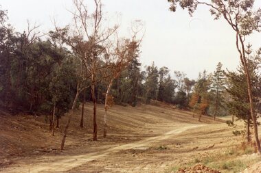
 Ringwood and District Historical Society
Photograph, Kubis Estate, North Ringwood on 10 June 1978. Trench for sewer below the manhole
E550 N7 The hole for the 27 feet deep well shows as a white patch, lower right. Part of a 51-photo record of the development of the "Kubis" Estate, Ringwood North, including road works to Debbie Place, Kubis Drive, Werac Drive, Manuelo Drive, Iluka Place and Glenvale Road. From the Jack Lundy Clarke collection. -
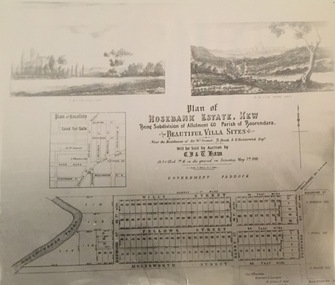 Kew Historical Society Inc
Print - Subdivision Plan, Rosebank Estate, Kew, Nineteenth Century
This work forms part of the collection assembled by the historian Dorothy Rogers, that was donated to the Kew Historical Society by her son John Rogers in 2015. The manuscripts, photographs, maps, and documents were sourced by her from both family and local collections or produced as references for her print publications. Many were directly used by Rogers in writing ‘Lovely Old Homes of Kew’ (1961) and 'A History of Kew' (1973), or the numerous articles on local history that she produced for suburban newspapers. Most of the photographs in the collection include detailed annotations in her hand. The Rogers Collection provides a comprehensive insight into the working habits of a historian in the 1960s and 1970s. Together it forms the largest privately-donated collection within the archives of the Kew Historical Society.A photographic reproduction of a plan in the Vale Collection of the State Library of Victoria. The plan shows the Rosebank Estate in Kew which was offered for sale in 1881. The subdivision was located in Studley Park and included lots in Redmond Street; Fellows Street; Wills Street; Molesworth Street; Barry Street and Princess Street. The surveyor of the subdivision was the local architect George Wharton.rosebank estate (kew), subdivisions -- studley park -- kew (vic.), thomas wills, wills family -
 Eltham District Historical Society Inc
Slide, Bonds Road, Lower Plenty, Mar. 1981
One of a series of images of road infrastructure focussed on Bonds Road, Lower Plenty, the section connecting Old Eltham Road with Rosehill Road, taken by Eltham Shire Council Planning and Engineering officers. They provide perspective of the changes in housing styles and road development that began sweeping in from the mid 1970s with increasing urbanisation of what was once more outlying suburbs and regions. All images have been identified with GPS35 mm colour positive transparency (1 of 13) Mount - Kodak Kodachrome CardProcessed Mar 1981infrastructure, roads, bonds road, lower plenty, old eltham road -
 Eltham District Historical Society Inc
Slide, Bonds Road, Lower Plenty, Mar. 1981
One of a series of images of road infrastructure focussed on Bonds Road, Lower Plenty, the section connecting Old Eltham Road with Rosehill Road, taken by Eltham Shire Council Planning and Engineering officers. They provide perspective of the changes in housing styles and road development that began sweeping in from the mid 1970s with increasing urbanisation of what was once more outlying suburbs and regions. All images have been identified with GPS35 mm colour positive transparency (1 of 13) Mount - Kodak Kodachrome CardProcessed Mar 1981infrastructure, roads, bonds road, lower plenty -
 Eltham District Historical Society Inc
Slide, Bonds Road, Lower Plenty, Mar. 1981
One of a series of images of road infrastructure focussed on Bonds Road, Lower Plenty, the section connecting Old Eltham Road with Rosehill Road, taken by Eltham Shire Council Planning and Engineering officers. They provide perspective of the changes in housing styles and road development that began sweeping in from the mid 1970s with increasing urbanisation of what was once more outlying suburbs and regions. All images have been identified with GPS35 mm colour positive transparency (1 of 13) Mount - Kodak Kodachrome CardProcessed Mar 1981infrastructure, roads, bonds road, lower plenty, rosehill road -
 Eltham District Historical Society Inc
Slide, Bonds Road, Lower Plenty, Mar. 1981
One of a series of images of road infrastructure focussed on Bonds Road, Lower Plenty, the section connecting Old Eltham Road with Rosehill Road, taken by Eltham Shire Council Planning and Engineering officers. They provide perspective of the changes in housing styles and road development that began sweeping in from the mid 1970s with increasing urbanisation of what was once more outlying suburbs and regions. All images have been identified with GPS35 mm colour positive transparency (1 of 13) Mount - Kodak Kodachrome CardProcessed Mar 1981infrastructure, roads, bonds road, lower plenty -
 Eltham District Historical Society Inc
Slide, Bonds Road, Lower Plenty, Mar. 1981
One of a series of images of road infrastructure focussed on Bonds Road, Lower Plenty, the section connecting Old Eltham Road with Rosehill Road, taken by Eltham Shire Council Planning and Engineering officers. They provide perspective of the changes in housing styles and road development that began sweeping in from the mid 1970s with increasing urbanisation of what was once more outlying suburbs and regions. All images have been identified with GPS35 mm colour positive transparency (1 of 13) Mount - Kodak Kodachrome CardProcessed Mar 1981infrastructure, roads, bonds road, lower plenty, old eltham road -
 Whitehorse Historical Society Inc.
Artwork, other - Ink Line Drawing, 26 Highview Gve., Burwood E, 1994
A property illustration by Margaret Picken Commissioned by the real estate agency Fletchers Real Estate for the purpose of advertising 26 Highview Gve., Burwood in 1994 Made by using Rotring ‘Rapidigraph’ drafting pens with Rotring ink on Rapidigraph polyester drafting film, double matte. This property is listed as having sold for $160,250 in 1994 Since being sold the land has been redeveloped, with nothing remaining of the house depicted in this drawing. Trained as a cartographic draftsman within the mining industry, Margaret Picken is an artist who worked producing property illustrations for real estate agencies in eastern suburbs of Victoria from 1983-2005. Retiring from the industry as technological changes favored coloured photography over illustrations, and commissioning companies over sole contractors.This artwork is of Historical Significance as a record of local domestic architecture.A black ink line drawing on drafters film by Margaret Picken, of 26 Highview Gve., Burwood East. An angled birds eye view from the street of a weatherboard house and carport. Extending to the backyards with pool, pagoda, and shed in the background. There are two hole punch holes on near the left edge. There are some crinkles in the paper near the top centre of the work. There is a two centimetre long mark along the centre top edge.26 Highview Gve., Burwood E Margaret Picken -94 Woodards B/Burnwhitehorse historical society, schwerkolt cottage, housing, architecture, margaret picken, burwood, house, garden -
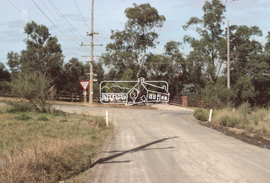
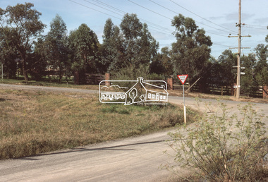
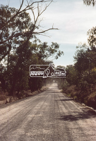
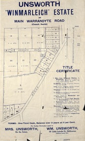 Ringwood and District Historical Society
Flyer, Land Sale Advertisement - Unsworth Winmarleigh Estate, Ringwood, Victoria - circa 1912
Advertisement and attachment for subdivision of land adjoining Warrandyte Road coach route in North Ringwood, with map showing layout of subdivision, summary of local features and services, and terms of sale. Subdivision includes Wonga Road (later Loughnan Road & Warrandyte Road), Unsworth Road, Through Road, Cross Street, and John Street. Contacts - Mrs Unsworth on the Estate or W.M. Unsworth, 58 Little Latrobe Street, Melbourne, Telephone Central 7207. -
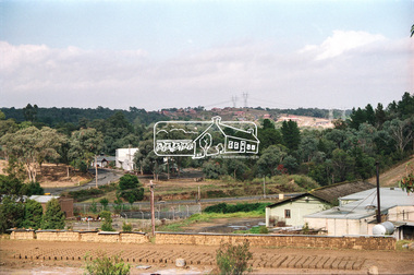
 Eltham District Historical Society Inc
Slide - Photograph, Aerial Photo (c.1987): Woodridge Estate, Eltham, c.Aug. 1990
Part of a presentation, "Roads and Byways of the Shire of Eltham", by Russell Yeoman to the 12 September 1990 Society meeting. Slides shown included copies of old photos and recent images ranging from the suburban streets of Eltham and Montmorency to the mountain roads of Kinglake. In the byways category are views of some iof the Shire's bicycle paths including then recently completed sections of the Main Yarra Trail at Lower Plenty.35mm colour positive transparency (1 of 37) Mount - Agfachrome Agfa CS System black 8 dotsinfrastructure, roads, aerial photographs, eltham, housing estate, woodridge estate -
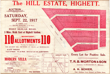 City of Moorabbin Historical Society (Operating the Box Cottage Museum)
Flyer - The Hill Estate, Highett, 1917
The land sales in the area stopped due to the 1890s depression. For the next 20 years real estate sales virtually stopped until after WWI.Example of the progress of the Municipality of MoorabbinAdvertising flyer for auction of real estate sales - plan of building blocks for saleThe Hill Estate, Highett - 110 allotments - Auction Saturday September 22, 1917 T.R.B. Morton & Sonpoint nepean road (nepean highway), turner street, sanford street, alfred street, peace street, highett, real estate, moorabbin -
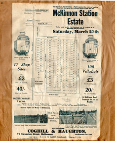 City of Moorabbin Historical Society (Operating the Box Cottage Museum)
Flyer - The Railway Estate, McKinnon, 1920
At the end of World War One, there was a renewed interest in residential land and a number of estates opened up in the Municipality of Moorabbin.Example of the progress of the Municipality of MoorabbinAdvertising flyer for auction of real estate sales - plan of building blocks for saleMcKinnon Station Estate - 100 Villa lots & 17 business lots - Auction Saturday 27 March 1920mckinnon station estate, graham ave, prince edward ave, station street, mckinnon road, real estate, mckinnon, auction, moorabbin -
 Eltham District Historical Society Inc
Photograph, Odyssey House Victoria, 28 Bonds Road, Lower Plenty, 6 March 1990
Odyssey House drug rehabilitation centre in Bonds Road, Lower Plenty is a distinctive landmark, especially when viewed from across the Yarra at Templestowe. It was built in the 1950’s as a seminary for the Blessed Sacrament Fathers. Because of the poor and circuitous road access, a suspension footbridge was built across the river. As well as providing easy access for the priests residents of Templestowe could attend services at the seminary. The bridge is now part of the Yarra Trails system.Colour photographlower plenty, bonds road, odyssey house