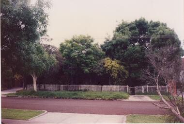
Showing 2866 items matching " fences"
-
 Lakes Entrance Historical Society
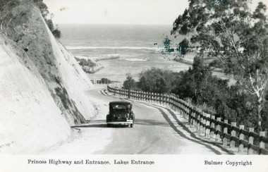
Postcard - The Entrance, Bulmer H D, 1930c
Black and copy 9 x 13.5, has inscription 'Princes Highway and Entrance, Lakes Entrance', ink spill on photo top right hand areaTinted small format postcard of the Princes Highway winding around Jemmys Point, between the steep road cutting and post and rail fence, entrance to Gippsland Lakes in the distance. Lakes Entrance Victoria waterways, roads and streets, vehicles -
 Lakes Entrance Historical Society
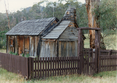
Photograph - Suggan Buggan School, Tambo Shire, 1994 c
Also identical copyPhotograph of the old school at Suggan Buggan. It shows a shingle roofed, timber slab building, large chimney area at one end, surrounded by timber fence set in bushland. Suggan Buggan Victoriaschools, buildings -
 Linton and District Historical Society Inc
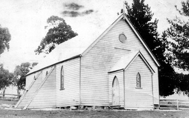
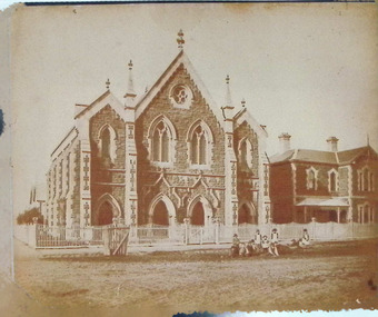
Photograph, Church Building : two possible identifications : Catholic Church at Berringa or St Mark's Church of England, Happy Valley
Two identifications of this building have been made: 1. The copy of the photograph in the LDHS collection was donated from the estate of Mag Gorman, and was identified as the Catholic Church at Berringa, which was moved after the gold mining days to Willowvale, where it burnt down in the bushfires of 1944. 2. The same photograph is on p. 249 of Joan Hunt's book "Springdallah", where it is identified as St Mark's Church of England, Happy Valley. This building was later moved to Skipton (1913) and then again to Carranballac (1924) (see "Centenary History of St Paul's - Linton, p. 25.)Black and white post card photograph of a wooden church, with trees and a post and rail fence around it. Two possible identifications: Catholic Church at Berringa or St Mark's Church of England, Happy ValleyStamped on reverse: "T.W.Nelson, Linton".catholic church berringa, catholic church willowvale, st mark's church of england happy valley -
 Lakes Entrance Historical Society
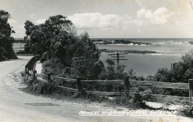
Postcard, Bulmer H D, 1920c
Black and white copy same sizeTinted postcard of a bend in the Princes Highway, Jemmys Point. It shows the road between the steep cutting and post and rail fence. Glimpse of footbridge to Bullock Island, entrance and hummocks. Lakes Entrance VictoriaPrinces Highway, Lakes Entrance topography, waterways, roads and streets -
 Bendigo Historical Society Inc.
Postcard - Alice McGregor Postcard Collection, 1900 - 1920
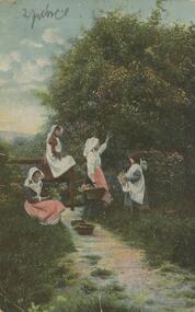
Alice McGREGOR Born: 1908; unknown parents. Possibly adopted by the Salter family? Electoral Roll 1936: Highland Terrace Kangaroo Flat. Alice Mary Salter and William Robert Salter living together; presumed to be sister and brother. William Robert Salter was killed in a MVA in Bendigo in 1937 aged 26. In Victoria in 1938, Alice Mary Salter married James Thomas McGregor (born Victoria 1917, died Victoria 1983, buried Fawkner Cemetery) Lived: 1968; 22 Wade Street Golden Square Alice McGregor Died: 1999 aged 91 at Anne Caudle Centre, Bendigo Buried: Kangaroo Flat Cemetery See additional research. Postcard Album of Alice McGregor contained 86 post cards.Postcard Album of Alice McGregor containing 86 post cards. See 1400 Colour photo of four women collecting flowers from a tree. One sitting on ground and one sitting on a fence. Addressed to Miss A. Stapleton, Arcade, Bendigo Sender - not given PO Dated 21.8.05, Bendigo postcard, collector, alice mcgregor -
 Melbourne Tram Museum
Photograph, model of a cable tram, c1940
Laminated reproduced photograph of a model of a cable tram set against a paling fence. Model of grip car and saloon - not numbered. Further details as to origin or date unknown. Print made with a course screen.trams, tramways, cable trams, models -
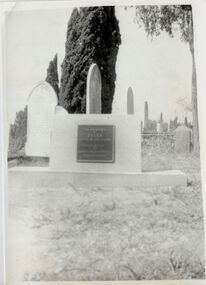
 Linton and District Historical Society Inc
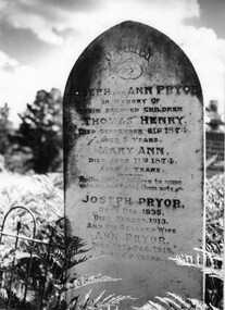
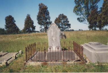
Photograph, Pryor Family Head stone
Black and white photograph of a grave headstone for Pryor family located in the Linton Cemetery. Has a part of cast iron fence to the left of the photograph also shows bracken ferns and tall trees behind.linton cemetery, grave, headstone, joseph pryor, ann pryor, thomas henry pryor, mary ann pryor -
 Lakes Entrance Historical Society
Photograph - Lake Tyers, 1920 c
Black and white photograph of Lake Tyers taken from Aboriginal Station showing island in lake and entrance in distance with animal hides drying along the fence sheep and cattle Lake Tyers Victoriawaterways, topography -
 Williamstown Historical Society Inc
Photograph - Methodist Church, Electra Street, Williamstown
Photograph - Methodist Church, Electra Street and Manse, Williamstown, with picket fence and children playing - front view, Andrew Rider.c.1882. Albumen silver, (copy) (original held in SLV-H86.98/634)methodist church, electra street, williamstown, manse -
 Lakes Entrance Historical Society
Postcard - Riversleigh
Also a second identical copy damaged 05390.1 in SparesSepia toned postcard of early style Australian country home double front with verandah and skillion on side with picket fence, family posed on verandah dressed in best clothes Tambo Upper VictoriaRiversleigh Tambo Upperhouses, guesthouses -
 Lakes Entrance Historical Society
Photograph, George and Sarah Grant Headstone, George Price Grant and wife Alice Jane Headstone, 2010 c
Funeral directors records show Alice Stocks nee Grant buried Lakes Entrance Cemetary which is incorrect as those who attended can attestColour photograph of headstone and iron fence at grave of George and Sarah Grant and daughter Alice Stocks in Bumberrah cemetery Victoria. Also photo of headstone of George Price Grant and wife Alice Jane genealogy, fashion -
 Orbost & District Historical Society
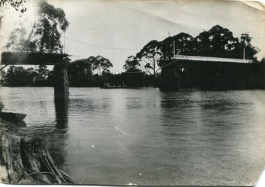
black and white photograph, January 1934
Damage estimated at £500,000 was caused by the 1934 floods in the Orbost district. This 1934 flood was devastating, destroying a section of the 1922 Orbost bridge, wrecking fences, bridges and roads, dumping silt and debris on the rich river flats and drowning cattle. The centre span of the Orbost Bridge was washed away. This item is a pictorial record of the 1934 floods, a significant part of Orbost's history.A black / white photograph showing the flood damage to the Snowy River Bridge. There is a gap in the bridge where the centre span has been washed away. In the background is a punt.orbost-floods-1934 natural-disasters-floods snowy-river-bridge -
 Glen Eira Historical Society
Document - Field Street, 11, Caulfield South
An unattributed, undated, colour photograph (100mm x 150mm) of 11 Field Street, Caulfield South, from the street, showing fence and trees. The file also includes a handwritten list of the owners of 11 Field Street, taken from Sands and McDougall’s Directory of Victoria 1923-1970.caulfield south, field street, jackson herbert, jackson a, jackson beryl -
 Phillip Island and District Historical Society Inc.
Sketch, 1890
The Cape Paterson shaft at Kilcunda Mine. A landscape - sea and cliffs in the background. A small shed with chimney beside poppet head. Track winding down to three miners. Wooden sheds, all with chimneys. In Foreground a picket fence on cliff on right of picture. A small tree stump on left.The Kilcunda MineCape Paterson Shaft - Kilcundalocal history, photography, photographs, slides, film, kilcunda mine, black & white, pen and ink sketch, miss elms san remo, james stirling -
Phillip Island and District Historical Society Inc.
Photograph, circa 1900
From left of picture showing the San Remo and Piers Hotels. A horse hitched to part fence on side of road. Bushes between hotels and foreshore. The Genesta, Jetty, Coal Jetty and Jetty leading to what could be baths jutting out into Westernport. Phillip Island foreshore in background.Sea shore looking across to Phillip Island. Large photograph extensive white - grey sky. Road and hotels in front of beach.local history, photography, photographs, slides, film, sea shore san remo, hotels, black & white photograph, miss elms san remo -
 Kew Historical Society Inc
Photograph, Grave of Ellen Quick, Boroondara General Cemetery, circa 1965, c. 1965
This work forms part of the collection assembled by the historian Dorothy Rogers, that was donated to the Kew Historical Society by her son John Rogers in 2015. The manuscripts, photographs, maps, and documents were sourced by her from both family and local collections or produced as references for her print publications. Many were directly used by Rogers in writing ‘Lovely Old Homes of Kew’ (1961) and 'A History of Kew' (1973), or the numerous articles on local history that she produced for suburban newspapers. Most of the photographs in the collection include detailed annotations in her hand. The Rogers Collection provides a comprehensive insight into the working habits of a historian in the 1960s and 1970s. Together it forms the largest privately-donated collection within the archives of the Kew Historical Society.The replacement grave and headstone of Ellen Quick in the Boroondara General Cemetery. "New memorial in Boroondara Cemetery to Ellen Quick first person buried there 12th Mar 1859. The Cemetery had no fence & they buried her where later the top drive is today. They exhumed the body & buried her in the Baptist Compartment. A Rev J. Foy was the minister."ellen quick, boroondara general cemetery, dorothy rogers, boroondara cemetery, kew cemertery, early burial, exhumation -
 The Beechworth Burke Museum
Photograph, c. 1905
Taken in c. 1905, depicted is a large group of children and adults dressed in formal attire sitting and standing upon a granite rock that is located in the centre of Queen Victoria Park. In front of the group is a wooden picket wire fence that sides the granite rock. On top of the rock is a gas lamp post.Originally known as the Beechworth Botanical Gardens, the Queen Victoria Park features a extensive collection of historic trees and plants, which have been listed on the Indigo Shire’s Significant Tree Register.Black and white rectangular reproduced photograph printed on matte photographic paperReverse: 6956 (in pencil)/ ©/ DONALD HAYES/ BEECHWORTH (stamped in orange ink)/entertainment album, burke museum, beechworth, queen victoria park, park -
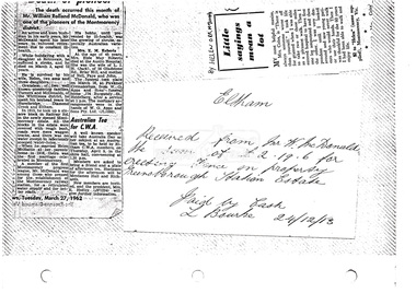 Eltham District Historical Society Inc
Document, Photocopy of receipts, etc
1. Death of pioneer; Obituary, William Rolland McDonald, 27 March 1962 2. Receipt from Mr W. McDonald the sum of of £2.19.6 for erecting fence on property Greensborough Station Estate, 24 December 1913 3. Little sayings mean a lot by Helen Orr McDonaldDigital file only scanned by EDHS from item on loan (photocopy only)early settlers, greensborough railway station estate, helen orr mcdonald, montmorency, obituary, receipt, w. mcdonald, william rolland mcdonald -
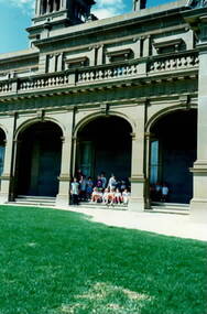 Sunbury Family History and Heritage Society Inc.
Photograph, Werribee Open Range Zoo, c1989
The children from Bulla Primary School were on a school excursion to Werribee Park Mansion and Open Range Zoo when this photograph was taken. They spent the day taken into the mansion before moving onto the zoo where they saw a variety of exotic animals wandering freely in large fenced allotments.The excursion was part of the children's environmental studies. A non-digital coloured photograph of a group of children gathered outside a grand mansion. bulla primary school, werribee park open range zoo, werribee mansion -
 Surrey Hills Historical Society Collection
Photograph, Geoff, Gwynne, Beryl and Isabel Mair and Bruce Kidd, c1926, c1926
David Miller (Dave) Mair (1879-1938) married Lily Vipond Deakin (1890-1945) in 1910. They had 5 children: Geoffrey David (1913-1970), Beryl (1916-1976), Gwynneth (1917-1997), Isabel Lillian (1921-1997) and Shirley Inez (1928-1968). Personal communication from Laurie Newton, Beryl's daughter: Dave and Beryl initially lived in East Melbourne after they married. Geoffrey, Beryl and Gwynneth were born in East Melbourne. They subsequently moved to Louise Avenue, Mont Albert and Isabel may have been born while they were there. Later they purchased 20 Barton Street, Mont Albert. Shirley was born after they moved to Barton Street. The children attended Mont Albert Central School. The photo was taken at the Kidd family property. The location of this has not been able to be traced. It may be in a rural area. This is part of a large donation related to the Deakin, Mair and Young families with connections to the Surrey Hills / Mont Albert area.A sepia copy photo with a cream border depicting 5 children in a back yard; the 3 girls and one boy are sitting on a rustic seat made from roughly-sawn timber; the other boy is standing behind them. All are looking away from the camera. The setting is a back yard with a high paling fence and rudimentary garden. A feature is a tree trunk turned into a seat. Behind the fence the rear of the house next door and the crown of a large eucalypt can be seen. REAR: In blue biro - "Gwen Beryl Isabel / Geoff (at back) / Bruce Kidd (2nd cousin / at his place" Handwriting is thought (at back)to that of Beryl Young (nee Mair). "39" in lead pencil on mid LH edge.children, back yards, beryl mair, geoff mair, isabel mair, gwynne mair, gwen mair, bruce kidd -
 Bacchus Marsh & District Historical Society
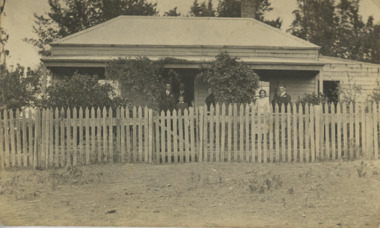
Photograph, Cottage Stamford Hill Bacchus Marsh 1883
Stamford Hill is on the western side of Bacchus Marsh. Main Street which runs in an East to West direction through the town runs directly up Stamford Hill. The precise location of the house or cottage in this image has not been identified and it appears to have been demolished. The identities of the two women and one girl in the picture are unknown.Small sepia unframed photograph on card with gold border framing photograph. Housed in the album, 'Photographs of Bacchus Marsh and District in 1883 by Stevenson and McNicoll'. The image shows a frontal view of a cottage. The cottage is behind a high timber fence but most of the cottage can be seen. Two young women are standing in front of the fence facing the camera. Standing between them is a young girl. A dog sits beside one of the women. Another dog stands in the gateway behind the girl.On the front: Stevenson & McNicoll. Photo. 108 Elizabeth St. Melbourne. COPIES CAN BE OBTAINED AT ANY TIME. On the back: LIGHT & TRUTH inscribed on a banner surmounted by a representation of the rising sun. Copies of this Portrait can be had at any time by sending the Name and Post Office Money Order or Stamps for the amount of order to STEVENSON & McNICOLL LATE BENSON & STEVENSON, Photographers. 108 Elizabeth Street, MELBOURNE stevenson and mcnicoll 1883 photographs of bacchus marsh and district, houses bacchus marsh -
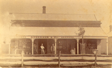 Bacchus Marsh & District Historical Society
Photograph, Anderson's Store, Main Street, Bacchus Marsh circa 1870s-1890s
This store in Main Street Bacchus Marsh was first opened by James Young in November 1866. In October 1869 it was purchased by William Anderson and was operated by members of the Anderson family until 1971. The site of the store was on the southern side of Main Street on the eastern side of Eddie Toole Park. On the opposite side of the street was the site of the former Post Office on the northern side of Main Street. The store was first named the Border Mills Store during James Young's ownership and was later known as the Border Store (Anderson & Co.).Small black and white photograph showing Anderson’s store. It shows a large stone building with a corrugated iron verandah which bears a painted sign of the name of the business: GROCERS. ANDERSON & Co. DRAPERS. Behind a brick parapet rises a hip roof with one chimney visible. Four men stand in casual poses ranged along the verandah. A post and rail fence runs along the road frontage. A tree is planted in an ornamental wrought iron plant protector on the inside of the fence.On the back in decorative print: “ New York Photographic Adelaide Travelling Brand Chas. F. Husband Manager.” In handwriting: Border store built by James Young 1866 owned by Anderson 1869-1972. BMDHS stamp and no. HS 411.shops bacchus marsh vic., anderson's store bacchus marsh, stevenson and mcnicoll 1883 photographs of bacchus marsh and district -
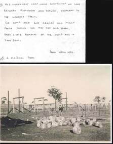 Bendigo Historical Society Inc.
Photograph - QC BINKS COLLECTION: INTERNMENT CAMP
5 copies of photos, all relating to internment camp near Tatura ? -between Rushworth and Tatura - Images shows rows of huts, inside fence line. Annotation by Q.C. Binks: a photo showing some of the huts of the No. 3 internment camp almost ready to receive the first of the German and Italian internees. Barbed wire fence and entanglement surrounded the camp The camp was in use during the 1939 - 45 war years. Very little remains today 2000. Photo April 1941.government, internment camp -
Glenelg Shire Council Cultural Collection
Photograph - Photograph - Portland Rifle Club, n.d
Black and white photo. Group photo - members of the Portland Rifle Club, sitting, standing, fence behind. Three men in front row holding rifles, man either side holding score boards -
Glenelg Shire Council Cultural Collection
Postcard, c. 1946
Sourced from Casterton Town Hall former Shire of GlenelgBlack and white photo/postcard, showing ? Island Park Casterton during 1946 flood. Tractor in flooded yard near shed. Tin back fence with 'The World's Favourite' written on it. (Rest of advertisement underwater)Back: Purple photographer's stamp. 'Postcard' - purple -
Glenelg Shire Council Cultural Collection
Photograph - Photograph - St. Stephen's Church, Portland, n.d
Black and white photo. View of St Stephen's Anglican church from Percy St. near Julia St. corner. Front and left side visible, blue stone fence, seat on nature stripBack: 'B.V.' top right corner, handwritten, blue biro '3 1/4 wide in prep' - handwritten, pencilst stephens, cofe, place of worship, percy street -
Glenelg Shire Council Cultural Collection
Photograph - Photograph - Dutton Way, n.d
Black and white photo taken from glass plate negative, attached to heavy card. Dutton Way looking towards Whalers Bluff, road with fence above beach and a horse tied up to post.Front: 'Dutton Way 1900' - black texta -
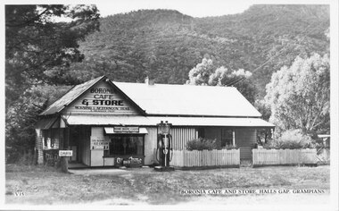 Halls Gap & Grampians Historical Society
Postcard - B/W, C 1930s
The picture is of Boronia Cafe and Store, which was situated one kilometre south of Halls Gap township.The postcard shows a building with a sign reading "Boronia Cafe & Store". The building has a picket fence at the front and a canvas awning on part of its verandah. There is a petrol pump at the front of the building and wooded hills behind.buildings, shops -
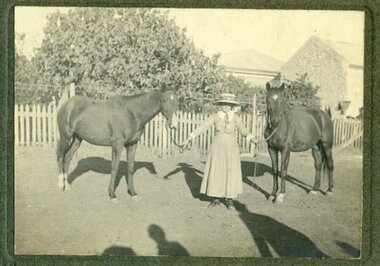 Ararat & District Historical Society (operating the Langi Morgala Museum)
Photograph, c.1920
This photograph is of a local identity, known as Dorrie, who lived and studied in the Ararat community in the late 1920s.Black-and-white photograph of a woman holding two horses by their reins outside of a house surrounded by picket fence and trees. Shadows appear in the foreground where the photographer would have been standing with their back to the sun. Rear: "To dear Miss Norman / With fondest love from / Dorrie".horses, homestead, ararat, dorrie, 1920 -
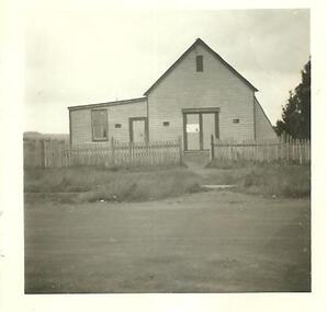 Streatham and District Historical Society
Picture, Streatham Hall
This shows the typical building structures of the time period. As the population grows in the area the need for a community meeting place becomes a requirement for the community. Local community rely on each other for company, support and social engagements.This building demonstrats the needs of the local community and the population in and around Streatham in 1888.Square picture in black and white showing the Streatham Hall. The picture is a shot of the front of a single storey weatherboard building with two doorways and one window in view. There is a picket fence running across the front of the building,Back: Stamped in green ink "317"building, rural, streatham, structures, areas, materials