Showing 3073 items matching " scale"
-
 Orbost & District Historical Society
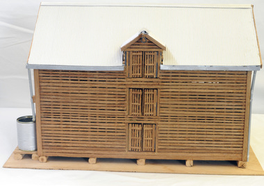
model, Hodge, Chris, 2006
This model was inspired by the Morgan barn on the Marlo Road, Orbost. It was built by Chris Hodge for the launch of the book, "Barns of the Snowy River" ( Reg. No.2138)The slatted barns are unique to the Orbost district.A wooden model of a three-storeyed slatted barn. The scale is approximately 30:1.The roof is corrugated cardboard painted silver. The waater tank is a tin can covered with corrugated cardboard. The down pipes are made from drinking straws. It stands on ply board.model handcraft woodwork barn -
 Federation University Historical Collection
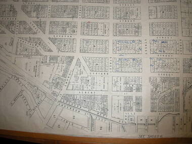
Plan, Ballaarat City Parish Plans, 1931, 09/03/1931
Large Scale plans showing streets, allotments, dimensions, crown grantees, dates granted, etc Sheet 2: Sturt Street, Rubicon Street, Pryor Street, Humffray Street, Sebastopol Street, Armstrong Street South, Fraser Street, Hickman Street ballarat, ballaarat, plans, city of ballarat -
 Federation University Historical Collection
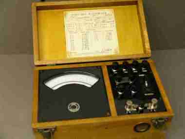
Instrument - Electrical Instrument, Portable Wattmeter: Type PW6, Serial No 2972
In 1993 this items was held in the Mt Helen Physics Department Optic Laboratory.Wattmeter type PWG, Range 0-1.5 kw, semi-circular scale. Three volt ranges: 150v, 300v, 600v. 50 Hz. In varnished wooden carry case, with hinged lid and leather carry strao. Calibration chart inside lid. Serial Number 2973scientific instrument, wattmeter, electrical engineering, laboratory, electrical instrument, a j william, mount helen campus, physics department, optic laboratory, a.j. william -
 Bendigo Historical Society Inc.
Map - CAMPBELL COLLECTION: BENDIGO AND DISTRICT MAPS, 30-1-29
Map. Ellesmere, Parish of Ellesmere, scale 20 chains to 1 inch. Total area 3926 acres. Prepared in W.P.B. from A. and P. Plans, by W.J. Galbraith, 30-1-29, to Bendigo along Fosterville. (number 381 in map cupboard 1)W.J.Galbraithmap, bendigo, agricultural lands -
Bendigo Historical Society Inc.
Map - CAMPBELL COLLECTION: BENDIGO AND DISTRICT MAPS, 16-5-29
Map. Egerton, Parishes of Egerton and Whirrakee. Scale 20 chains to 1 inch. Total area 5401 acres. Prepared in W.P.B. from A. and C.L. Plans by W.J.G. 16-5-29. To Rochester 12 miles. (number 366 in map cupboard 1)W.J.G.(W.J.Galbraith)map, bendigo, allotments -
Bendigo Historical Society Inc.
Map - CAMPBELL COLLECTION: BENDIGO AND DISTRICT MAPS, 8-2-29
Map. Bagshot, Parishes of Wellsford, Ellesmere and Bagshot. Scale 20 chains to 1 inch. Total area 5037 acres. Prepared in W.P.B. from A.C.l. and D.B. Plans, W.J. Galbraith, 8-2-29 (number 353 in map cupboard 1)W.J.Galbraithmap, bendigo, agricultural lands -
Bendigo Historical Society Inc.
Map - CAMPBELL COLLECTION: BENDIGO AND DISTRICT MAPS, 12-2-29
Map. Axedale, Parishes of Ellesmere and Axedale. Scale 20 chains to 1 inch. To the west is Wellsford. Total area 4156 acres. Prepared in W.P.B. from A and P plans by W.J. Galbraith 12-2-29. (number 352 in map cupboard 1)W.J.Galbraithmap, bendigo, agricultural lands -
Bendigo Historical Society Inc.
Map - CAMPBELL COLLECTION: BENDIGO AND DISTRICT MAPS, 1929
Map. Campaspe, Parish of Kimbolton. Total area 4117 acres. Campaspe River, Kimbolton. Scale 20 chains to 1 inch. Prepared in W.P.B. form Parish and Assessment Plans. G.W.L. 9-4-29. (number 351 in map cupboard 1)map, bendigo, allotments -
Bendigo Historical Society Inc.
Map - CAMPBELL COLLECTION: BENDIGO AND DISTRICT MAPS
Map. Longlea, Parishes of Eppalock and Axedale. Scale 20 chains to 1 inch. Total area of map 2372 acres, with Bendigo 9 1/2 miles away. H.A. Darby 18-6-29. (number 349 in map cupboard 1)H.A Darbymap, bendigo, allotments -
Bendigo Historical Society Inc.
Photograph - FORTUNA COLLECTION: AERIAL PHOTO FORTUNA 1945
Black and white photo of Fortuna area 1945. On bottom of image printed in black : ' Fortuna - Circa 1945, approximate Scale 1:1 400, Produced from aerial photography flown 1100 hrs 7th July 1945.' Image is very blurry. -
 Bendigo Historical Society Inc.
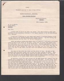
Document - BILL ASHMAN COLLECTION: CORRESPONDENCE
Copy of a letter dated 25 January, 1937, from Frank A. Stevenson to R. H. S. Abbott. Letter details the changes in the colour of the water from the diesel engines on the 180 Gold Mining Coy., Bendigo, after the Scale Buoys were installed.sciences, instruments - general, scalebuoy, bill ashman collection - correspondence, stevenson bros. motor service station, r h s abbott, crown hotel, 180 gold mining coy, frank a stevenson -
 Bendigo Historical Society Inc.
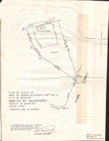
Document - CROWN ALLOTMENT 406A (PLAN) JOSS HOUSE
Plan of Survey of part of Crown Allotment 406A Sec E. City of Bendigo. Parish of Sandhurst. County of Bendigo. Scale 1:500. (Copy of Original). As at 21 February 1979. This survey shows the location of the Joss House and the portion of land where it is located.plan, bendigo, joss house, crown allotment 406a (plan), joss house -
 Ballarat Tramway Museum
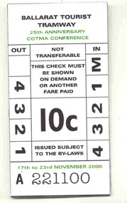
Ephemera - Ticket, Ballarat Tramway Museum (BTM), COTMA Conference Ballarat 2000, Nov. 2000
Replica tram ticket - large size - made available, but not actually distributed?, for the November 2000 COTMA Conference Ballarat. Has a common number, A221100, large scale replica of BTM's 10c ticket, with some printing in green ink. Printed by Andrew Cox?trams, tramways, cotma, conferences, tickets, btm -
University of Melbourne, Burnley Campus Archives
Plan, Grace Park Feature Plan, 1901-1983
(1) City of Hawthorn plan dated August 1983. Drawing No P12/24 Sheet 1 of 1. Surveyed: L.B. & H.K. Traced H.K. Scale 1:500. (2) Photocopy of map of area, Grace Park coloured in. 1901 handwritten on page.hawthorn, grace park -
Clunes Museum
Plan - PLANS, DEPARTMENT OF PUBLIC WORKS, POST & TELEGRAPH OFFICE CLUNES, 1878
THE DEPARTMENT OF PUBLIC WORKS PUT THE CONTRACT OUT TO TENDER, LEWIS AND ROBERTS OF BALLARAT, CONTRACTORS, WON THE TENDER AT A PRICE OF 4099 POUNDS. THE FOUNDATION STONE WAS LAID BY GOVERNMENT OFFICIALS ON FRIDAY 25TH OCTOBER 1878.1 PHOTOCOPY OF DRAWING NO.1 INCLUDES SIDE AND FRONT ELEVATIONS, GROUND, FIRST FLOOR AND ROOF DRAWINGS .2 PHOTOCOPY OF THE DRAWING NO. 2 INCLUDES SIDE AND FRONT ELEVATIONS, GROUND, FIRST FLOOR AND ROOF DRAWING SCALE IS 8 FEET TO ONE INCHON REVERSE: WRITTEN IN BLACK BIRO "C.- TAMMY VAN DRUIN, 17 TAIL ST SEBASTOPOL 3336" .1 & 2 INITIALLED BY GWW (GEORGE WILLIAM WATSON) AND STAMPED WITH GOVERNMENT SEAL "DEPARTMENT OF WORKS MELBOURNE VICTORIA" post office, telegraph office, george william watson, department of public works, lewis & roberts ballarat -
 Andrew Ross Museum
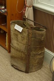
Miner's Bucket
Dates from gold-mining period in Queenstown (St. Andrews) Caledonian Diggings. Used for lift ore to the surface by windlass in small-scale shaft mines.Heavy leather bucket with iron reinforcing and handle. Panels are stitched and joined with thonging Ironwork is hand-forged and rivetted in place. -
 Mansfield RSL Sub Branch
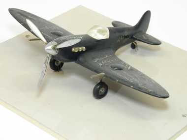
Model, Aircraft, LAC. F.L. Cochrane, RAAF, circ. 1944
A handmade scaled replica of a World War Two Supermarine Spitfire aircraft for Tropical Operations, for defence of Australia and operations in the South Pacific flown by Australian Airmen.Signed by highly decorated World War Two Pilots Handmade wooden Spitfire Fighter Plane World War Two. Dark Blue paint, handmade metal propeller, 20mm cannon, exhaust manifold and undercarriage and perspex canopy. Mounted on buff coloured acrylic baseboard. Autographed by known & unknown World War Two Fighter Pilots and ACE Fighter Pilots.model, aircraft, spitfire, raaf, world war two, -
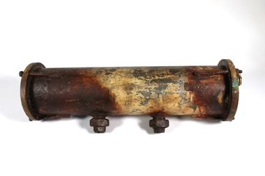 Bendigo Historical Society Inc.
Functional object - BILL ASHMAN COLLECTION: SCALEBUOY PIPE
Scalebuoy. Invented by Hartley Abbott and patented under the name of the Bendigo Electronic Company, made in various sizes & for different applications, such as to prevent scaling in the boilers at mines. Scalebuoy case is a 57 long cylinder 13 centimetres diameter with two pipe fittings coming from it. Each end of the cylinder is removable. sciences, scalebuoy, bill ashman collection -
 Seaworks Maritime Museum
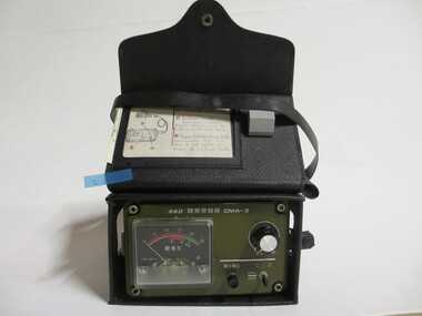
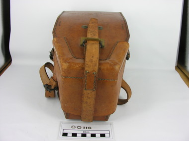
Gas Detector
1990 -24/04: To "Salvageman Ltd" at Douglas (IOM)One gas detector housed inside a black leather carry case, with a carry strap, and a pocket at back of carry case.1993 circa.on detector: "OMA-3/ON/OFF/ TYPE OMA-3/ KOMYO Paper card inserted in case, written with pen: "1) Turn on/off switch "ON"/ 2) Battery Check:/ Hold down smaller/ Button. Needle must be / within lower red scale/ 3 Zero Calibration Scale/ Press Larger Dial and Turn to Set Needle on/ Green on Lower Scale" handwritten on case: "PWO 3076" Sticker on case: "GASTECH/CALIBRATED/ Date 31-8-93/ Next Due/ 31-2-94/ Initials MW/ Serial no. 6479" Card attached by string, written in pencil: " PWO 3076/ Gas Detector/ Model no. 6479 [From the Howard Smith Collection]" -
 Women's Art Register
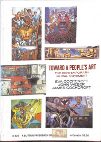
Book, Eva Cockcroft, John Weber, James Cockcroft, Towards a People's Art. The Contemporary Mural Movement, 1977
Written by two muralists and a sociologists the book documents the community based mural movement in the late 60s and early 70s in Canada and the USA.Booknon-fictionWritten by two muralists and a sociologists the book documents the community based mural movement in the late 60s and early 70s in Canada and the USA.political art, revolutionary art, community arts, large scale works -
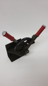 B-24 Liberator Memorial Restoration Australia Inc
Bomb Release Quadrant- Scale Model, B24-Liberator Memorial Restoration Fund Incorporated, December 2018
After an eight year international search for a complete bomb quadrant to fit the B24- Liberator fuselage it was decided to create a replica. This scale mode was used to prove the methodology.This scale model allowed us to manufacture a full size complete working replica.This replica is now installed in the B24-Liberator and completes the operational system.Quarter circle quadrant with operating levers and security bracket. Body is dark green with two red operating handles. -
 Bendigo Military Museum
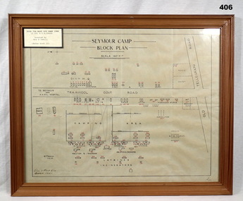
Map - PLAN, FRAMED
LT COL BENJAMIN THOMAS ROY CHADD No's 10594, VX20311, 1st and 2nd AIF. Refer 2039 for Service History also 2034P. Plan, detailing Seymour Camp Block Plan, Signals 7th Aust Div Camp 1940, re LT COL BENJAMIN THOMAS ROY CHADD. Tan coloured frame, glass front, cardboard backing, detail of camp layout, scale 160' = 1".documents - maps/plans, military history - army, frames -
 Frankston RSL Sub Branch
Dial Sight
Dial sight used with QF 25 pdr field gun. This delicate device was mounted on a fitting beside the barrel of the gun and used to accurately aim the weapon when firing. This device has an eyepiece and has a circular, rotatable scale ring which is graduated in degrees.ww2, dial sight, sight, 25 pdr, qf 25 pdr, 25 pounder, field gun -
 Federation University Historical Collection
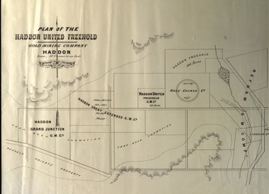
Plan, Plan of the Haddon United Freehold
Plan of the Haddon United Freehold. Scale: 15 chains to 1 inch (1:11,880) WGS 84 Centroid Lat: 37 degrees 35' 04" S Long: 143 degrees 40' 52" E NS: 2.8 km EW: 5.4 kmhaddon, plan, haddon united, haddon freehold, haddon race course co, haddon racecourse co, haddon united freehold, reform gold mining company -
 Ballarat Tramway Museum
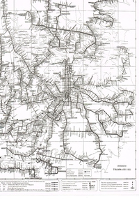
Map, South Pacific Electric Railway, c1970's
702.1 Map of Sydney Trams - diagrammatic in 1921, includes electric and steam, shows streets, railways and where starting (Not original a reproduction) 702.2 - as above, but shows track layout, crossovers etc. - more to scale, also a reproduction. Image added 20-12-2016.trams, tramways, map, sydney -
Bendigo Historical Society Inc.
Plan - SANDHURST BOYS CENTRE SITE PLANS: LISLE STREET UNITS
16 Working drawings including Floor Plans and Elevations Prepared by Michael DeVincentis, Architects; Wellington St Strathfieldsaye. October-November 1995. Scale 1:200. No 9538. Also Survey Plan for Lot 69D 3950 Sq m. Location unknown 16.02.2023.plan, bendigo, institutions, victoria. department of planning and development -
University of Melbourne, Burnley Campus Archives
Map, Kosciusko Primitive Area, Vegetation & Associated Features, 1972
2 copies of map dated 1972 by Division of Plant Industry, Commonwealth Scientific and Industrial Research Organization. Shows: General Vegetation Approximately 2,000 feet-7,000 feet; and Alpine and Subalpine Complex Approximately 5,000 feet-7,000 feet. Scale 1:31,680.vegetation, mount kosciusko area, alpine vegetation, d.j. wimbush, r.t. morland -
 Bacchus Marsh & District Historical Society
Map, Parish of Yangardook, County of Bourke 1876
The parish of Yangardook lies directly north of the township of Melton. The locality of Toolern Vale lies in the centre of this parish. A single page paper map showing the plan for the Parish of Yangardook in the in the County of Bourke. Scale 40 chains to 1 inch. The map is pasted into a bound volume containing 76 maps or plans in total. High resolution digital image stored on BMDHS computer network. Photo lithographed at the Department of Lands and Survey, Melbourne by J. Noone, 1.8.76yangardook parish maps, toolern vale victoria maps -
 Bacchus Marsh & District Historical Society
Map, 'Map of Darley' circa 1877-1897
This map shows the early laid out streets and roads for the village of Darley and the main roads and streets in the central area of the township of Bacchus Marsh. The date of the map is not known. Landmarks indicated on the map including the Anglican Church in Church Street (Gisborne Road), opposite the Presbyterian Church, and the Baptist Church at its pre-1898 Main Street location suggest the map is dated between 1877 and 1897. Landholders names can be seen on some of the allotments of land marked in this map, including the names Clifton, Cosgrove, O'Hagan, McFarlane, Nagle, O'Hagan, Simpson and Vallence.A single page paper map showing the village of Darley and the township of Bacchus Marsh. Scale 10 chains to 1 inch. The map is pasted into a bound volume containing 76 maps or plans in total. High resolution digital image stored on BMDHS computer network. darley victoria maps, bacchus marsh victoria maps -
 Whitehorse Historical Society Inc.
Map - Parish Map, Parish of Nunawading, 1892
A map copied from 'Directory maps - parishes and counties' dated 26 Nov 1892. Compiled and lithographed by G.S. Bonney. The map includes roads, railway, stations, names of property owners. It has a scale [ca. 1:31,680] 40 chains to an 1 inch.A map copied from 'Directory maps - parishes and counties' dated 26 Nov 1892. Compiled and lithographed by G.S. Bonney. The map includes roads, railway, stations, names of property owners. It has a scale [ca. 1:31,680] 40 chains to an 1 inch.non-fictionA map copied from 'Directory maps - parishes and counties' dated 26 Nov 1892. Compiled and lithographed by G.S. Bonney. The map includes roads, railway, stations, names of property owners. It has a scale [ca. 1:31,680] 40 chains to an 1 inch.maps, parish of nunawading