Showing 10629 items
matching maps
-
 Warrnambool and District Historical Society Inc.
Document, Ella Webb, Warrnambool artist, Street Walks of Warrnambool, 2018
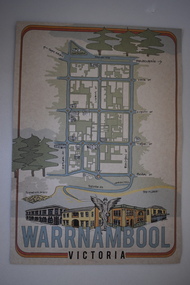
This is a tourist guide to Warrnambool produced by a local artist, Ella Webb, in conjunction with the Warrnambool and District Historical Society. It includes a sketch map showing the location of some points of interest – buildings and sites of historical interest, places of interest that are no longer existing, some natural features (mainly along the coast) and some information about incidents and people in the past. It is an attractive broadsheet that is a useful guide for visitors to Warrnambool. This sheet is of interest as a modern-day tourist map produced in an artistic fashion by a local Warrnambool artist.This is a single sheet of thick paper printed on both sides in green, brown, yellow and beige tonings. One side of the sheet has sketches of buildings and places of interest and printing and the other side has a sketch map of some of the main streets of Warrnambool and some of its attractions. -
![An account of the English colony in New South Wales : with remarks on the dispositions, customs, manners, &c. of the native inhabitants of that country, to which are added, some particulars of New Zealand / compiled, by permission, from the Mss. of Lieutenant-Governor King by David Collins [Volume 1]](/media/collectors/550653872162f11fb04854aa/items/575ba01ad0cdd1229c1f675d/item-media/57600f26d0cdd11990766530/item-fit-380x285.jpg) Kew Historical Society Inc
Kew Historical Society IncBook, State Libraries of South Australia, An account of the English colony in New South Wales : with remarks on the dispositions, customs, manners, &c. of the native inhabitants of that country, to which are added, some particulars of New Zealand (Vol.1), 1971
[Adelaide : Libraries Board of South Australia, 1971] 2 v. : maps (part col.), plates (part col.) ; 28 cm. Facsimile of: London : T. Cadell jun. and W. Davies, 1798. Includes an account of a voyage performed by Captain Flinders and Mr. Bass abstracted from the journal of Mr. Bass. Volume 1non-fictionnew south wales - descriptions and travel, new zealand - descriptions and travel -
 Melbourne Tram Museum
Legal record, Commonwealth of Australia - Copyright Office, "Commonwealth of Australia - Re copyright Tramway Routes", 8/12/1925 12:00:00 AM
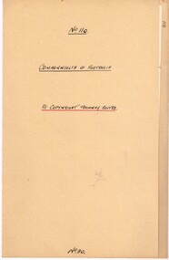
... Maps ...Legal document within a light brown manila document - titled "Commonwealth of Australia - Re copyright Tramway Routes". Typed on pre-printed paper, Copyright Office, No. 14428, registering the MMTB as the copyright owner in a literary work, a map, entitled "Melbourne's Tramway Routes and Time Tables". Dated 8-12-1925, with date stamp of 22/12/1925 as being received by the Board. Address to A. S. Whyte of the Board. Folder has file number "110" written on the outside.trams, tramways, mmtb, commonwealth government, legal agreements, copyright, maps -
 Melbourne Tram Museum
Poster, Yarra Trams, "Melbourne Tram Network", Dec. 2012
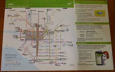
... Maps ...Full colour poster printed on a vinyl plasticized based sheet, titled "Melbourne Tram Network" - showing a diagrammatic layout of Melbourne tram routes, Myki ticket notes and where tickets can be obtained, information numbers (PTV, phone applications) and information on Tram Tracker, twitter and other contact systems. Map shown as effective April 2011, and printed December. 2012. Has the document information on the right hand side of the poster. See Reg Item 625 for a later version.trams, tramways, yarra trams, ptv, maps, tramtracker, myki -
 Melbourne Tram Museum
Poster, Public Transport Victoria (PTV), "Melbourne's Free Tram Zone Map", Sep. 2014
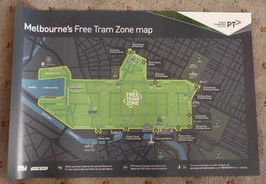
... Maps ...Set to two full colour posters printed on a plasticized based sheet, titled ""Melbourne's Free Tram Zone Map". 626.1 - Poster showing the tram lines that the free travel is allowed, locations, land marks, contact numbers and has the PTV logo in the top right hand corner. 626.2 - Poster showing the logo or tram stop id that the free tram zone travel applies to. See Reg Items 1954, and 1956 for associated printed materials and 2790.2 for driver announcements.trams, tramways, yarra trams, ptv, maps, free tram, melbourne -
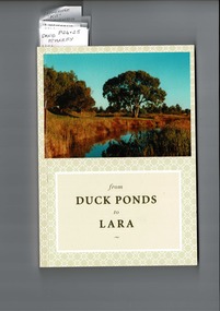 Lara RSL Sub Branch
from Duck Ponds to Lara, Booklet from Duck Ponds to Lara, 2004
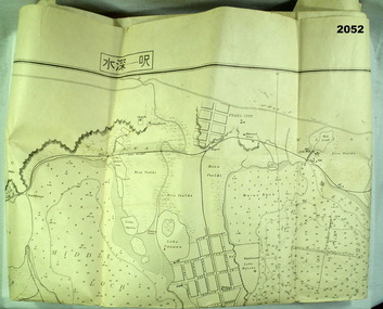
Lara - Duck Ponds history and input by local population. Insight into the History of a small community.Local knowledge of Lara's History, some items are not well known, Excellant referamce.Soft back booklet a collection of of memories "From Duck Ponds to Lara." Published by the Lara Heritage Festival Inc 2004. Edited by Mary Budd, Caroline Delaney, and John Grainger. Contributions of short stories to the project have come from local residents. Booklet also came with a fold-up heritage map of Lara printed on both sides. The booklet is tagged for the names of contributors who are members of Lara R. S. L. Front of the Booklet is half covered by a photograph of Lara Creek and environes. Booklet also came with a fold-up heritage map of Lara printed on both sides.duck ponds, lara -
 Bendigo Military Museum
map - MAP, JAPANESE, C. 1930's
Map, Japanese, B&W, yellowed "Pearl Harbour". Japanese and English translation, Map No. 2015.documents - maps, military history, pearl harbour -
 Stawell Historical Society Inc
Map, Stawell Gold Mines, Plan View of Township Area Showing Known Old Workings. 2003, 13/06/2003
Two AO Maps that Overlap Showing Old workings on Map of Town North of Patrick StreetScale 1 : 5000 -
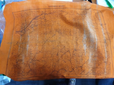 Clayton RSL Sub Branch
Memorabilia - Silk Escape Scarf, WW2
Escape scarf was issued to all military personnel, both army and airforce and personnel in theatres of war. The scarf was designed to provide information on escape routes if the soldier/pilot was captured. The scarf was donated to the RSL by Cedric Hamilton Chindit WW2.Unusual orange silk escape scarf with Burma and North Burma map. Colour may indicate that the scarf was primarily to be used for nighttime viewing.orange silk scarf with map of burma on one side and a map of north burma on the other side.One side - Central Burma Second side - North Burmaworld war two, second world war, ww2, wwii, scarf, burma, escape scarf -
Whitehorse Historical Society Inc.
Document, 'Through her eyes', 2007
The Women's map of Melbourne City. Key dates, map, significant sites and services.The Women's map of Melbourne City. Key dates, map, significant sites and services. 2nd edThe Women's map of Melbourne City. Key dates, map, significant sites and services. melbourne, suffrage, women -
Bendigo Historical Society Inc.
Map - CAMPBELL COLLECTION: BENDIGO & DISTRICT MAPS
Map. copy. Raywood, Neilborough, Sebastian, Yarraberb, Woodvale. (number 372 in map cupboard 1)map, bendigo, country lands -
 Bendigo Historical Society Inc.
Photograph - CASTLEMAINE GAS COMPANY COLLECTION: PHOTO MAP
7 males standing around looking at a detailed map of terrain, several plastic markers on the map.Kodakbusiness, retail, gas and fuel -
 Bendigo Historical Society Inc.
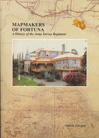
Book - FORTUNA COLLECTION: MAPMAKERS OF FORTUNA
MAP MAKERS OF FORTUNA - A HISTORY OF THE ARMY SURVEY REGIMENT - 234 pages with maps, illustrations, photos.Valerie Lovejoyhistory, army survey regiment, bendigo, army survey regiment, fortuna, cartography, mapmakers -
 Bendigo Historical Society Inc.
Map - JACK FLYNN COLLECTION: GIRGARRE, 14/10/1943
Map: Parish of Girgarre , County of Rodney. Parish plan. Same map as 10100.20 but in poorer condition.By Authority, H.E.Daw, Government printer Melbourne. Drawn and Reproduced at the Dept, of Lands and Survey, Melbourne, Victoriamap, rodney, girgarre, girgarre, county of rodney -
 Bendigo Historical Society Inc.
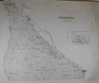
Map - JACK FLYNN COLLECTION: GUNBOWER, 1935
Map: County of Gunbower, map sheet showing the whole of the County of Gunbower and all of the Parishes within.map, gunbower, county, gunbower -
 Bendigo Historical Society Inc.
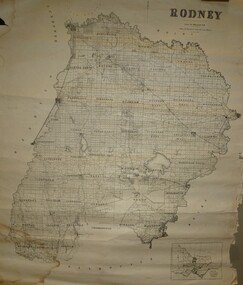
Map - JACK FLYNN COLLECTION: RODNEY, Revised in 1935
Map: County of Rodney, map sheet showing the whole of the County of Rodney and all of the Parishes within.Drawn at the Department of Lands and Survey, Melbourne. Revised to 1935map, rodney, parish plan, rodney -
Bendigo Historical Society Inc.
Map - SALISBURY WEST, 14/10/1943
Map: Salisbury West, County of Gladstone. Parish plan ( number 179 in Map Cupboard 1)map, gladstone, parish plan, salisbury west , county of gladstone -
Bendigo Historical Society Inc.
Map - PARISH OF LAANECOORIE, 13/10/1930
Map: Parish of Laanecoorie, County of Bendigo. Parish plan ( number 176 in Map Cupboard 1)map, bendigo, parish plan, laanecoorie -
Bendigo Historical Society Inc.
Map - LANGWORNOR, 17/07/1942
Map: Langwornor, County of Dalhousie. Parish Plan, coloured ( number 165 in Map Cupboard 1)map, dalhousie, parish plan, langwornor, county of dalhousie -
Bendigo Historical Society Inc.
Map - COSTERFIELD, 2/09/1939
Map: Costerfield, Counties of Dalhousie and Rodney. Parish plan ( number 163 in Map Cupboard 1)map, dalhousie, parish plan, costerfield, counties of dalhousie and rodney -
Bendigo Historical Society Inc.
Map - ELMORE, 7/08/1911
Map: Township of Elmore, Parish of Elmore, County of Bendigo ( number 159 in Map Cupboard 1)map, bendigo, township, elmore, county of bendigo -
Bendigo Historical Society Inc.
Map - GOORNONG, 1/10/1906
Map: Township of Goornong, Parish of Goornong, County of Bendigo ( number 154 in Map Cupboard 1)map, bendigo, township, goornong, county of bendigo -
Bendigo Historical Society Inc.
Map - GOORNONG, Revised 5/06/1926
Map: Town of Goornong, Parish of Goornong, County of Bendigo ( number 153 in Map Cupboard 1)map, bendigo, township, goornong, county of bendigo -
Bendigo Historical Society Inc.
Map - HUNTLY, 7/01/1904
Map: Township of Huntly, Parish of Huntly, County of Bendigo ( number 150 in Map Cupboard 1)map, bendigo, township, huntly, parish of huntly, county of bendigo -
Bendigo Historical Society Inc.
Map - CITY OF BENDIGO SHEET 2, No date visible
Map: City of Bendigo Sheet 2, Town plan ( number 143 in Map Cupboard 1)map, city of bendigo sheet 2, city streets -
Bendigo Historical Society Inc.
Map - HARCOURT, 2/04/1917
Map: Town of Harcourt, County of Talbot. Parish plan (number 264 in map cupboard 1)map, talbot, township, harcourt -
Bendigo Historical Society Inc.
Map - TOWNSHIP OF HEATHCOTE SHEET 2, Circa 1935
Map: Township of Heathcote sheet 2. Parish plan (number 254 in map cupboard 1)map, dalhousie, township, heathcote -
Bendigo Historical Society Inc.
Map - PARISH OF DIGGORRA, 23/02/1911
Map: Parish of Diggorra, County of Bendigo. Parish plan ( number 247 in Map Cupboard 1)map, bendigo, parish plan, diggorra -
Bendigo Historical Society Inc.
Map - TARNAGULLA, Examined May 1883
Map: Tarnagulla, Counties of Gladstone and bendigo. Parish plan ( number 244 in Map Cupboard 1)map, gladstone, parish plan, tarnagulla, gladstone -
Bendigo Historical Society Inc.
Map - EPPALOCK RESURVEY, Circa 1880
Map: Eppalock resurvey, hand draughted parish plan ( number 239 in Map Cupboard 1)map, bendigo, parish plan, eppalock