Showing 1453 items
matching firmness
-
 National Wool Museum
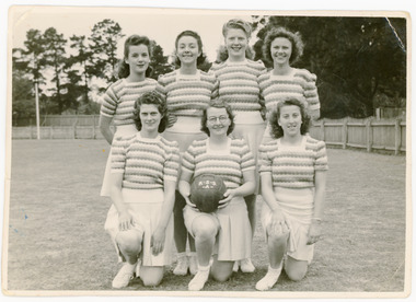
Photograph, c1943
Depicts seven members of an R.S.&S. Mill 'A' basketball team. Those pictured are: Dorothy Beckley, Ruth Ramsden, Violet Jones, Jean Clark, Jean Jones, Edie Ramsden, Pat Rogan.Between the 1920’s and 1950’s the YWCA, Blue Triangle and local committee of representatives organised an Inter House Athletics Day for Girls in Geelong and Melbourne. Local Geelong business, such as the surrounding woollen mills, business firms and church clubs would form teams of seven women to compete in a variety of sports such as bowls, basketball, hockey, cricket and soccer. Events such as these were organised to encourage women to participate in competitive sports and network with other women in the workforce.Depicts seven members of an R.S.&S. Mill 'A' basketball team.textile mills staff, textile mills sporting teams, textile mills, returned soldiers and sailors mill, sport, photographs, textile mills - staff, textile mills - sporting teams -
 Whitehorse Historical Society Inc.
Article, Firm's move lifts job hopes, 1990
National clothing manufacturer, Holeproof, will relocate to Nunawading.National clothing manufacturer, Holeproof, will relocate to Nunawading. The company will employ 600 staff, creating jobs for local people.National clothing manufacturer, Holeproof, will relocate to Nunawading.clothing industry, holeproof -
 Whitehorse Historical Society Inc.
Article, Firm will help find work, 1992
Two former mayors of Nunawading, Wal Riddell and Cr Bruce Artkinson Cr Kevin Abbott and former Jaycee National President Peter McPhee have formed a company to help young unemployed people find work.Two former mayors of Nunawading, Wal Riddell and Cr Bruce Artkinson, Cr Kevin Abbott and former Jaycee National President Peter McPhee have formed a company to help young unemployed people find work.Two former mayors of Nunawading, Wal Riddell and Cr Bruce Artkinson Cr Kevin Abbott and former Jaycee National President Peter McPhee have formed a company to help young unemployed people find work.unemployment, riddell, wal, atkinson, bruce, abbott, kevin, mcphee, peter -
Whitehorse Historical Society Inc.
Article, Firm commitment, 27/04/1994 12:00:00 AM
Article by Katy Ashley-Griffiths on Evelina North-Coombes, engineer at Melbourne Water's Mitcham office.Article by Katy Ashley-Griffiths on Evelina North-Coombes, engineer at Melbourne Water's Mitcham office.Article by Katy Ashley-Griffiths on Evelina North-Coombes, engineer at Melbourne Water's Mitcham office.north-coombes, evelina, melbourne water -
 Whitehorse Historical Society Inc.
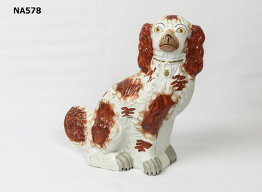
Decorative object - Ornament
6th May 2009 A large earthenware figure of a spaniel made in the 19th century in Staffordshire and used as a fireside ornament. Also referred to as Staffordshire dogs. They were purchased by errant husbands to comfort irate wives.|Stoke, Burslem, Hanley, Longton and Tunstall were known as the “Five Towns” of the Staffordshire potteries. In the 19th century there were more than 1000 firms working at various times, amongst them Wedgwood, Spode and Ridgway. Largely because of Josiah Wedgwood and the canal system, and later the railways English ceramics spread far and wide. A vast export trade to the Americas and India was from the port of Liverpool. Staffordshire became the pottery supplier of the World. Most factories made figures and tea and dinner sets.|The Comforter Dogs were copied and made by more than one pottery.Staffordshire dog - no makers mark. Right foot cracked. Repair on ear. Some cracks on body.ceramics, porcelain, ornaments -
 Whitehorse Historical Society Inc.
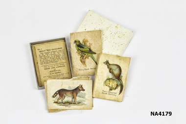
Memorabilia - Box - Cigarette silks, 1911 - 1917
These type of cigarette silks were included in WD & HO Wills cigarette packets to induce women in particular to take up smoking.|The Word 'Cartophilic?|It is believed that this unusual word was coined in the 1920s by Col. Bagnall, an Englishman, who was the father of the hobby of cigarette card and trade card collecting. It is thought to be a combination of a Latin word, 'carto' meaning 'card and the Greek word 'philic', meaning 'love'.- lover of cards. The term originally related to the collection of the two types mentioned, however, our Society has included postcards in the range of items collected by our members.|The Cigarette Card|The cigarette card began its evolution in the United States of America, in the early 1880s as a plain piece of cardboard used by tobacconists to protect the cigarettes which were sold in that era, not in packets, but loosely. A purchaser would buy his cigarettes then wrap them in paper around the small piece of cardboard, which acted as a stiffener. In fact, for many decades, cigarette cards were known as 'stiffeners' in the USA.|The card depicting 'The Marquis of Lome' is reputed to be the first known cigarette card issued. This is thought to have been in 1879. It did not take long for an enterprising entrepreneur to recognise the advertising potential of the cigarette card, and, very soon, the cards began displaying popular images, often in sets. This had the effect of youngsters, wishing to complete their sets, harassing their fathers to buy a specific brand of cigarettes. The kids who collected cards in the days when they were being issued in the cigarette packets, would hang around outside the local tobacconist's shop, pestering the men who had just bought a packet of cigarette, with the cry: 'can I have the cig can mister?'|It is a proven fact that, here in Australia during the 1930s, at least one set had one card deliberately withheld and issued very sparingly. This card is No. 86 (Mrs Jack Crawford) in the Carreras 'Turf Personality Series'. Thus, in a set of reasonably easy cards to get, this one card is a constant source of frustration for the collector, and as such, commands a premium when it comes to price. It is not hard to imagine the young collector nagging his to Dad to keep buying 'Turf' cigarettes to enable him to finish the set.|From small beginnings the cigarette card soon gave rise to a booming industry in itself. Artists and writers were|employed to produce the cards, which were miniature works of art and served as little encyclopaedia's for the children of the day. By the 1930s cards were being issued in the countless millions. It has been stated, in one book on the history of cards; that 450 million sets of a series produced and issued by the prolific issuer of cards in the United Kingdom, WD & HO Wills. As each set contained 50 cards you would need a calculator with a very long result window to see the answer to how many cards of that series were in circulation.|Australia's involvement would appear to have its beginnings with the English and American firms who shipped their tobacco products here and the cards of American Tobacco Company (ATC) are found in great numbers in early Australian collections; many featuring Australian subjects, e.g. 'Australian Parliament a 1901 issue. Earlier U.S. sets depicting Australians included Goodwin & Co's, so called. 'Australian Series' with cricketers and Australian Rules footballers who were on the sporting scene during the 1880s. The caption of one of theses cards reads:|'W.Hannysee. Captain Port Melbourne Football Club' which enables us to pinpoint the year of issue to either 1889 or 1890.|On the Australian scene the first local manufacturer who issued cards seems to have been The National Cigarette Company of Australia Proprietary Limited, whose 'Tally Ho' packets contained cards from a series of thirteen featuring the touring 'English Cricket Team 1897-8' Of the few Australian manufacturers who issued cards, only two companies issued more the two sets.|Undoubtedly the cards issued by the Melbourne firm Sniders & Abrahams (later Sniders & Abrahams Pty Ltd) are the 'jewels in the crown' of Australian card issues. They issued some thirty-three series, with numerous sub-series and allied issues such as metal badges, metal football shields, celluloid flags etc., which ensured that the hobbyist had a vast range from which to collect. Sporting themes – football, cricket, horse racing – dominate, indicating the Australians' love of sport and the outdoors was as strong in those earlier times as it is today. Military, animals and birds themes were also to the fore, with a touch of culture being provided by 'Shakespeare', 'Dickens', actresses and even classical 'Statuary'. Humour was not forgotten with 'Cartoons and Caricatures', 'Naval and Cricket (double meaning) Terms' and the 'Jokes' series. Art and history were covered by the artist, S.T. Gill's 'Views of Victoria in 1857' while the stereoscopic 'Views of the World' expanded the collectors' knowledge of the world as a whole.|The Sniders & Abrahams series began in 1904 and by 1919 the company was in decline and was eventually taken over by G.G. Goode & Co. Ltd. This company produced one set only, the highly collectable 'Prominent Cricketer Series' issued in 1924. During the early to mid-1920s, J.J. Schuh Tobacco Pty Ltd issued eight series, again containing the popular subjects of sport and war. At least two provincial tobacconists, Lentens of Bendigo and Baillies of Warrnambool, issued private football series. The last series of cards issued by a truly Australian firm was Dudgeon & Arnell's '1934 Australian Cricket Team'.|The Australian market was not neglected by the English companies with WD & HO Wills, Godfrey Phillips and Ogdens all making their contributions. By far the most active issuer was the long-established company Wills, whose 'Cricketers' of 1901 heralded the flood of Australian series, which continued into the mid-thirties.|The onset of the 1939-45 World War sounded the death knell of the cigarette card and very few post-war issues were made, certainly not here in Australia.|The Trade Card|The Trade Card is a non-tobacco item used by manufacturers to promote and advertise their products, in the same way that cigarette cards were. It is uncertain exactly when they were first produced, but in the USA, non-collectable cards were issued by firms in the early 1800s. These were more akin to a latter day 'business card'. It was not until the 1850s, when coloured and pictorial cards were issued to advertise and promote products that the Trade Card|became a collectable item. Many beautiful lithographic cards were produced in this early era and they are very mu sought after by collectors. By the 1870s the issues of Trade Cards became more prolific and it is from this era that more cards are seen.|Again, it is difficult to pinpoint the exact date of the first Australian Trade Card and it may be that the highly collectable and extremely rare 'American Candy Co's' - 'Pure Caramels' Australian Rules football card, issued i 1891, is the earliest series. This confectionery firm was located in Fitzroy, a Melbourne suburb. To date only two subjects have been seen.|Another early set was 'Flags', issued by F.H.Fauldings & Co. It featured testimonials of seven English cricketers who toured Australia with the 1894/5 Test team. Fauldings was an Adelaide based firm which manufactured medicinal toiletries, soaps and oils, using the distinctly Australian eucalyptus oil. During the 20th century a multitude of Australian businesses issued trade cards, with confectionery manufacturers such as Hoadleys, Allens, Sweetacres and Australian Licorice producing the majority of them. Again sporting themes dominated with the ever popular Aussie Rules football cards being the most numerous. Cricket issues ran a close second.|Apart from sporting cards, almost every subject imaginable was covered by the Trade Card, making it the most diverse and interesting branch of cartophilly. In contrast to the Cigarette Card, which had its demise prior to the Second World War, the Trade Card is still alive and well.|We all are aware of the long running 'Birds of Australasia' series put out by Tuck-fields Tea and 1 doubt if there is a kitchen drawer in Australia that has not got one or two of these informative and attractive cards floating about in it. These cards were first produced in the early 1960s and are still being inserted in that company's packets of tea. Such is also the case with Sanitarium Health Foods, manufacturers of the well known Weetbix, who began issuing cards, with a wide range of subjects, in the early 1940s and continue to do so.|The 1940s and 1950s saw the two breakfast food giants, Kornies and Weeties dominating the card scene. Kornies footballers were in production fora decade from 1948 to 1959. Four years later in 1963, we saw the start of four decades of Scanlens bubble-gum card issues, both football and cricket. In the mid 1990s, with the end of the Scanlens/Stimorol cards, the Trading Card came on the scene. These cards do not fit under the umbrella of the Trade Card, having been produced and marketed purely as a 'collectable' with no connection whatsoever to any product, which of course is necessary for an item to be classified as a Trade Card.|The earliest British postcard was issued in 1870 and was designed to send short messages; the stamp was printed on the card, therefore it did not require an envelope. It was considered by many to be lowering the postal standards because the texts were no longer private. However the cards were a great success as on the first day of issue in 1870, half a million passed through the London postal centre.|The first illustrated postcards are said to be those introduced by a French stationer in 1870. He realized that French troops fighting in the Franco-Prussian War needed to be able to send short messages to their families and designed a 'postcard' to suit the purpose. As many of the soldiers were illiterate they decorated their cards with sketches of their many activities at the front rather than writing; thus creating a picture postcard. Private enterprise soon saw the great financial possibilities of this new easy and attractive way of communication by post; also sending a postcard cost less than postage for letters. It was correctly assumed that postcards were likely to overtake letter writing in many instances.|Between 1875 and 1882 every state in Australia introduced official postcards, N.S.W. first and Tasmania last. Each state produced a simple type of postcard with a pre printed stamp allied to that state. The stamp side stated 'The Address Only To Be Written On This Side'; the reverse side sometimes carried a simple illustration or decoration with space fora short message, each state extolling their own state's virtues. In 1901, with the advent of Federation, the new Government became responsible for all postal services in Australia and produced postcards for sale in every state. With several mail deliveries each day in most towns, postcards were used for many purposes. One 1906 postcard, with an illustration of fruit, was sent from Mrs X in the morning to her greengrocer ordering her fruit and vegetables to be delivered that afternoon. Another lady asks her charlady to 'come this afternoon'.|Australian private enterprise also began selling pictorial postcards, most companies using the very experienced German printing works who were the worlds best in the field of lithography and fine detailed colour-printing. Many of these beautiful German cards still exist today, 100 years later. Australia did have a few fine printers but they were in the minority. Black and white postcards printed in Australia in the early 1900s were often of good quality e.g. postcards printed by 'The Bulletin', illustrating the works of 'The Bulletins' top artists.|Between c1903-09 The Melbourne company Osboldstone and Atkins etc. printed coloured reproductions of 46 J.A. Turner bush/rural life paintings, which were generally of good quality and became hugely popular and still sought after today. Like thousands of homes in Europe, Britain and U.S.A., many Australia homes had albums of cherished postcards, which were given pride of place for visitors to see and enjoy.|Postcard collecting remained popular but was changing with the times. About 1912 the Australian photographer George Rose of Melbourne began to produce topographical B/W real photographic postcards covering most of Australia and other photographers began to do likewise. These cards soon found their way into collections as well.|WWI and the horrors of war suddenly changed the world; postcards were still in great demand but the subject matter was far more serious. Thousands of postcards from the trenches in European war zones arrived in Australia to be included in family albums. Propaganda and recruitment messages were produced to encourage enlistment. Australian postcard producers began to create cards decorated with gum leaves, boomerangs, wattle etc., which were designed for sending to Australian troops serving overseas. Very few 'pretty' cards were available, as access to the Gentian printing works was no longer possible and exporting of postcards from Britain was very limited. By the end of WWI people had other more serious problems to contend with and the avid postcard collecting hobby declined, fold greetings took over and topographical photographic postcards became a small but steady income for the producers and newsagents etc. in every town.|Fortunately many of these old postcards still exist and are avidly collected by a new generation or postcard collectors. The Australian Cartophilic Society Inc. is one of four postcard/cigarette card organizations in Australia. They are, N.S.W. Post Card Collectors Society; Queensland Card Collectors' Society Inc. and West Australian Card Collectors|Society, and across the Tasman there is a New Zealand Postcard Society.|References:|Picture Postcards of the Golden Age A Collector's Guide by Toni & Valmai Holt. Picture Postcards in Australia 1898 - 1920 by David CookBox of Cigarette Silks ( 10 ) depicting animal motifs, which were placed in cigarette packets as an incentive for women in particular to smoke.|WD & HO Wills|Produced 1911 - 1917personal effects, smoking accessories, recreations, collections -
Embroiderers Guild Victoria
Tool - Thimble, 1890's
Silver thimble made in America c 1880's when there was still a huge amount of domestic sewing down by hand and a thimble was an essential tool to protect the finger tip when pushing a needle through fabric. Sterling silver thimbles were special for their precious metal and this one came into the collection in a presentation box (T 513 1) Simons Bros of Philadelphia, PA USA were a very large jewellery manufacturing company which started c 1840's, with successful mechanisation the firm was able to increase production and sell its products in the booming 1870-1880's and is still in business in 2024.Sterling Silver Thimble with dimpled top half and panelled base 4 (size) on panel on lower band. Inside apex: Cursive S in a shield = Simons trademark -
Moorabbin Air Museum
Document - Handbook of Approval of Firms, Department of Civil Aviation
-
Moorabbin Air Museum
Document (Item) - Correspondence relating to GAF coordinating with a British firm on the Jindivik project, UK Nav 2(a) Meetings E.B.L. Activities in U.K
-
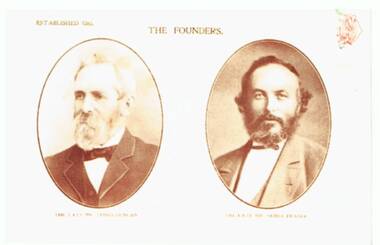 Ballarat Tramway Museum
Photograph - Colour Photocopy/photocopies, c2014
Has a strong association with the founders of the tramcar building firm in Adelaide - Duncan and Fraser.Photocopy or reproduction photograph from a book of the photograph of the founders of Duncan and Fraser - James Duncan and James Fraser. Printed on HP photograph paper. Not known who made the image.trams, tramways, duncan fraser, tram 29 -
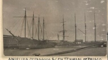 Queenscliffe Maritime Museum
Furniture - Bunk, sailor's, 1918 - 1928
Anieura. Four-masted wooden schooner, 1328 tons. Built California, 1918 as the Oronite. Reg. Melbourne, 1928. Lbd 236.5 x 42 x 29. Last captain, de Carteret. Stripped of anything of value at the Yarra Street Pier, Geelong, in 1932; burnt to recover her copper and brass, and sunk off Avalon Bach, two kilometres east of Point Lillias. She had been seized for debt. @ Her wreckage is scattered and overgrown, covered in light silt in 4 metres. [NWR],[LC],[NSC]A relic from the broken up Barque 'Anieura' in 1932/33: BARQUE ANIEURA. Left to Sink in Mud. GEELONG Monday -The hulk of the barque Anieura, which has been idle in Corio Bay for more than four years, was towed to a spot near Bird Rock on the northern shores of the outer harbour on Monday. The Anieura was built for the timber trade and made a journey to Australia. The owners then decided that the vessel was unsuitable for this trade, and she was sold to an Australian firm. The ship was placed in Corio Bay, and remained at anchorage for about three years before an effort was made to sell her. This being unsuccessful most of the fittings, were disposed of, and the hulk was taken to Fletcher's pier to be out of the way of shipping. The Victorian Salvage Co's offer to the Geelong Harbor Trust to dispose of the hulk was accepted. The 300 tons of road metal ballast was removed, and a quantity of timber taken out. The vessel was towed through the channel this morning and run aground near Bird Rock just outside of the north-east extremity of the bar where it is away from shipping. More timbers will be stripped from the vessel, and it is likely that she will be allowed to sink into the mud. The Argus Tuesday 4 April 1933. A wooden bunk from the 'Anieura', drawers underneath with brass handlesanieura, bunk, port phillip -
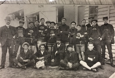 Kew Historical Society Inc
Photograph, Kew Flyer Team, c.1912
In 1903, an article in the Box Hill 'Reporter' noted that the Kew Flyer Cycle business had been started in 1893 by Harry F. Cooper, who was "the oldest cycle maker in the district". By 1903, the Kew Flyer business was located at 8 (later 14) Cotham Road where it was to remain an institution until its closure. Seven years later, W.D. Vaughan, in his 'Jubilee History of Kew, Victoria' (1910) wrote that: "Several cycling clubs have been born and died, suffering chiefly from the migration of the leading spirits in the organisations, but since 1900 the ‘Kew Flyer’ road race, instituted by Mr. H. F. Cooper, has been the cycling event of the year among local riders. It is run on the White Horse Road at Blackburn." Early newspaper reports record that distance of the Race was initially 10 miles but by 1906, the event was 15 miles, starting from the Travellers' Rest Hotel in Blackburn. Cooper's Kew Flyer business in Cotham Road introduced new technologies and models throughout its 56-years of operation. By 1908, it was claimed that the shop had been enlarged with new "workshops and [the] latest lathes and cycle building tools. [It] Is now one of the most up-to-date Cycle Works in Victoria". By the First World War, Cooper had expanded his business to include motorbikes with "Precision Engines". The Kew Flyer business and the annual road races continued through the War, even though a number of its staff left for the front. One of these was [Pte] Robert Charles Field Richardson, who joined the 6th Battalion, fought and was wounded at Gallipoli, and died of his wounds in a hospital in Alexandria, Egypt in 1915. In 1917, the death of Private H.S. Herbert was announced. He had been the winner of the Kew Flyer Cycle Road Race in 1913. He died in action in France, having fought at Gallipoli and in France at the Battle of Pozieres. The majority of bicycles advertised by Cooper were designed for men, although bikes for women and 'juveniles' were advertised as early as 1918, so they were probably manufactured throughout the period. Harry Cooper was to sell his Kew Flyer business in 1936, after 39 years of trading. The business he began continued until 1949.This is a very rare image [the location of the original is now unknown] of a Kew Flyer team. The photo was sourced and remained in the possession of the historian Dorothy Rogers, whose brother was an early member of staff in the firm. The photo is historically significant as it is the only known photograph of a Kew Flyer Team, and possibly the only known photo of Harry F. Cooper, the founder of the firm and a key figure in Victorian cycling history. Photograph, the first of two, of an earlier album photograph of the Kew Flyer Team in uniform with trainers and workers of the company. One of the men in the photograph is probably Harry Cooper, the proprietor of the Kew Flyer business in Cotham Road, Kew. Harry Cooper was the sponsor of one of the best known trader cycle races in Melbourne. The photograph remained in the possession of the Rogers family until its donation to the Society by John Rogers in 2015.Handwritten annotation by the historian Dorothy Rogers on reverse: "Kew Flyer Team about 1912-13. Coopers Cycle Shop Cotham Rd opp. Kew Post Office".kew flyer, harry f cooper, trader bike races - victoria - kew, kew flyer team -
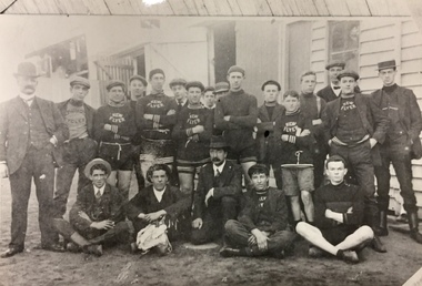 Kew Historical Society Inc
Photograph, Kew Flyer Team, c.1912
In 1903, an article in the Box Hill 'Reporter' noted that the Kew Flyer Cycle business had been started in 1893 by Harry F. Cooper, who was "the oldest cycle maker in the district". By 1903, the Kew Flyer business was located at 8 (later 14) Cotham Road where it was to remain an institution until its closure. Seven years later, W.D. Vaughan, in his 'Jubilee History of Kew, Victoria' (1910) wrote that: "Several cycling clubs have been born and died, suffering chiefly from the migration of the leading spirits in the organisations, but since 1900 the ‘Kew Flyer’ road race, instituted by Mr. H. F. Cooper, has been the cycling event of the year among local riders. It is run on the White Horse Road at Blackburn." Early newspaper reports record that distance of the Race was initially 10 miles but by 1906, the event was 15 miles, starting from the Travellers' Rest Hotel in Blackburn. Cooper's Kew Flyer business in Cotham Road introduced new technologies and models throughout its 56-years of operation. By 1908, it was claimed that the shop had been enlarged with new "workshops and [the] latest lathes and cycle building tools. [It] Is now one of the most up-to-date Cycle Works in Victoria". By the First World War, Cooper had expanded his business to include motorbikes with "Precision Engines". The Kew Flyer business and the annual road races continued through the War, even though a number of its staff left for the front. One of these was [Pte] Robert Charles Field Richardson, who joined the 6th Battalion, fought and was wounded at Gallipoli, and died of his wounds in a hospital in Alexandria, Egypt in 1915. In 1917, the death of Private H.S. Herbert was announced. He had been the winner of the Kew Flyer Cycle Road Race in 1913. He died in action in France, having fought at Gallipoli and in France at the Battle of Pozieres. The majority of bicycles advertised by Cooper were designed for men, although bikes for women and 'juveniles' were advertised as early as 1918, so they were probably manufactured throughout the period. Harry Cooper was to sell his Kew Flyer business in 1936, after 39 years of trading. The business he began continued until 1949.This is a very rare image [the location of the original is now unknown] of a Kew Flyer team. The photo was sourced and remained in the possession of the historian Dorothy Rogers, whose brother was an early member of staff in the firm. The photo is historically significant as it is the only known photograph of a Kew Flyer Team, and possibly the only known photo of Harry F. Cooper, the founder of the firm and a key figure in Victorian cycling history. Photograph, the second of two, from an earlier album photograph of the Kew Flyer Team in uniform with trainers and workers of the company. One of the men in the photograph is probably Harry F. Cooper, the proprietor of the Kew Flyer business in Cotham Road, Kew. Harry Cooper was the sponsor of one of the best known and oldest trader cycle races in Melbourne. The photograph remained in the possession of the Rogers family until its donation to the Society by John Rogers in 2015.Handwritten annotation by the historian Dorothy Rogers on reverse: "Kew Flyer Team from very old photo".kew flyer, harry f cooper, trader bike races - victoria - kew, kew flyer team -
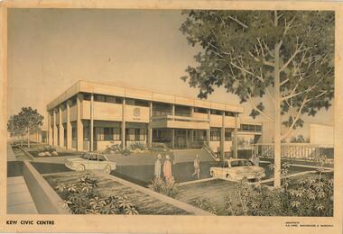 Kew Historical Society Inc
Drawing, AK Lines, Macfarlane & Marshall, Kew Civic Centre, c.1970
The Kew Civic Centre (A K Lines, MacFarlane & Marshall, 1972) was built next to the Kew Civic Hall (A C Leith & Bartlett, 1960) on the site of the former mansion Ordsall (later renamed South Esk). Whereas the entrance to the Civic Hall was positioned off Civic Drive, the main entrance to the Civic Centre faced Cotham Road, as shown in the undated perspective drawing of the proposed building. The Civic Hall was used for public functions and performances, while the Civic Centre was used for civic offices. It also contained the Council Chamber. The building opened in 1972, following the relocation of the councillors and council officers from the former Town Hall in Walpole Street (now a Woolworth's supermarket). Following the amalgamation of the former City of Kew into the City of Boroondara in 1994, the Civic Centre was sold to Trinity Grammar School. The exterior of the Centre has been modified by Trinity Grammar.A report for Heritage Victoria (date) describes how two architectural firms dominated the designs for new civic buildings in Victoria during the post war period. The report claims that: "An interesting sub-theme in the erection of post-war municipal offices in Victoria is that a considerable proportion were designed by the same three or four Melbourne-based architectural firms, who established themselves as the leading specialists in this type of work. The two most prolific firms in this regard were A K Lines, MacFarlane & Marshall, and A C Leith & Bartlett; both, in fact, had made names for themselves as designers of local government offices prior to the Second World War. Lines' office, for example had designed the Eltham Shire Offices in 1941, while Leith's firm had been responsible for the celebrated Heidelberg Town Hall in 1937). Both practices parleyed this early experience into a lucrative post-war career, designing numerous municipals offices well into the 1970s." (Survey of Post-War Built Heritage in Victoria, Built Heritage Pty Ltd, 2010.) The perspective drawing importantly captures the original design and function of the exterior of the building and its public entrance.Hand-coloured perspective sketch of the new Kew Civic Centre, completed in 1972 to designs by A K Lines, MacFarlane & Marshall; and located on the corner of Charles Street and Cotham Road, Kew. The sketch represents the front elevation of the building and its relation to the preexisting Kew Civic Hall at right. The three storey building features strong vertical concrete buttresses that extend across the three levels. KEW CIVIC CENTRE / A K LINES, MACFARLANE & MARSHALLkew civic centre, a.k. lines, macfarlane & marshall, architectural drawings, civic buildings -- kew (vic.), town hall -- kew (vic) -
![Book, A Journey Through Melbourne's East / [by] Fletchers Pty Ltd, 2008](/media/collectors/550653872162f11fb04854aa/items/5d03458521ea7b0950500c7e/item-media/5ebbc47c21ea670348e8dbc7/item-fit-380x285.jpg) Kew Historical Society Inc
Kew Historical Society IncBook, A Journey Through Melbourne's East / [by] Fletchers Pty Ltd, 2008
127 p. : ill. (some col.), ports. ; 26 x 26 cm. fletcher & parker (firm) - history., real estate agents - victoria - balwyn north - history, melbourne (vic.) - history - pictorial works -
 Kew Historical Society Inc
Plan, Studley Park Estate, 1910
Prue Sanderson, in her groundbreaking ‘City of Kew Urban Conservation Study : Volume 2 - Development History’ (1988), summarised the periods of urban development and subdivisions of land in Kew. The periods that she identified included 1845-1880, 1880-1893, 1893-1921, 1921-1933, 1933-1943, and Post-War Development. These periods were selected as they represented periods of rapid growth or decline in urban development. An obvious starting point for Sanderson’s groupings involved population growth and the associated economic cycles. These cycles also highlighted urban expansion onto land that was predominantly rural, although in other cases it represented the decline and breakup of large estates. A number of the plans in the Kew Historical Society’s collection can also be found in other collections, such as those of the State Library of Victoria and the Boroondara Library Service. A number are however unique to the collection.The Kew Historical Society collection includes almost 100 subdivision plans pertaining to suburbs of the City of Melbourne. Most of these are of Kew, Kew East or Studley Park, although a smaller number are plans of Camberwell, Deepdene, Balwyn and Hawthorn. It is believed that the majority of the plans were gifted to the Society by persons connected with the real estate firm - J. R. Mathers and McMillan, 136 Cotham Road, Kew. The Plans in the collection are rarely in pristine form, being working plans on which the agent would write notes and record lots sold and the prices of these. The subdivision plans are historically significant examples of the growth of urban Melbourne from the beginning of the 20th Century up until the 1980s. A number of the plans are double-sided and often include a photograph on the reverse. A number of the latter are by noted photographers such as J.E. Barnes.Coloured lithograph of a subdivision plan of the Studley Park Estate, bordered by Yarra, Willsmere Road and the Outer Circle Railway line. The estate was listed in 1910 and was the subject of a planning dispute between the developer and the Town of Kew in relation to flood levels and the suitability of the land for housing. In many cases the names of streets were subsequently changed. The layout was also affected by the creation of the Eastern Freeway. A newspaper report of the day described the subdivision as a: "GOLDEN OPPORTUNITY. We are pleased to submit for PRIVATE SALE that magnificent ESTATE, situated only 4 1/2 miles from the Melbourne General Post Office, STUDLEY PARK ESTATE. KF/NV. Doubtless the CHEAPEST LAND EVER OFFERED having extensive frontages to the prettiest spot on the River Yarra and the National Park, commanding lovely river and landscape views, and acknowledged to be the finest land available so close to the city. The PRICES ARE EXTREMELY MODERATE; The TERMS ARE SIMPLY MARVELLOUS. NO DEPOSIT. NO DEPOSIT. NO DEPOSIT. Allotments and prices to suit everyone."subdivision plans - kew, studley park estate -
 Kew Historical Society Inc
Plan - Subdivision Plan, Goldthorns House Estate, 1940
Pru Sanderson, in her groundbreaking ‘City of Kew Urban Conservation Study : Volume 2 - Development History’ (1988), summarised the periods of urban development and subdivisions of land in Kew. The periods that she identified included 1845-1880, 1880-1893, 1893-1921, 1921-1933, 1933-1943, and Post-War Development. These periods were selected as they represented periods of rapid growth or decline in urban development. An obvious starting point for Sanderson’s groupings involved population growth and the associated economic cycles. These cycles also highlighted urban expansion onto land that was predominantly rural, although in other cases it represented the decline and breakup of large estates. A number of the plans in the Kew Historical Society’s collection can also be found in other collections, such as those of the State Library of Victoria and the Boroondara Library Service. A number are however unique to the collection.The Kew Historical Society collection includes almost 100 subdivision plans pertaining to suburbs of the City of Melbourne. Most of these are of Kew, Kew East or Studley Park, although a smaller number are plans of Camberwell, Deepdene, Balwyn and Hawthorn. It is believed that the majority of the plans were gifted to the Society by persons connected with the real estate firm - J. R. Mathers and McMillan, 136 Cotham Road, Kew. The Plans in the collection are rarely in pristine form, being working plans on which the agent would write notes and record lots sold and the prices of these. The subdivision plans are historically significant examples of the growth of urban Melbourne from the beginning of the 20th Century up until the 1980s. A number of the plans are double-sided and often include a photograph on the reverse. A number of the latter are by noted photographers such as J.E. Barnes.The first subdivision of Goldthorns created the Goldthorns Hill Estate. Following that subdivision, seven additional lots were offered between Normanby Road, Argyle Road and Lady Loch’s Drive on the proviso that the estate, including Goldthorns was not sold as a single lot. The subdivision plan advises that the lots are situated in one of the most charming and popular residential areas in Kew and is surrounded by modern homes. Typically, the subdivision plan proposes the advantage of its proximity to Cotham Road and the tram to Collins Street. Because of the elevation of Goldthorns, much is made of the ‘bright, sunny and extensive outlook to the Northern Ranges’ and that it overlooks the Yarra Valley. One of the more interesting aspects of the plan is that it shows the outline of Goldthorns in the mid to late 1920s. Its profile today remains virtually the same."Goldthorns" House Estate at topsubdivision plans - kew, goldthorns house estate -
 Kew Historical Society Inc
Plan, Sydney Arnold Best & Co, Field Place, Kew, c.1929
Pru Sanderson, in her groundbreaking ‘City of Kew Urban Conservation Study : Volume 2 - Development History’ (1988), summarised the periods of urban development and subdivisions of land in Kew. The periods that she identified included 1845-1880, 1880-1893, 1893-1921, 1921-1933, 1933-1943, and Post-War Development. These periods were selected as they represented periods of rapid growth or decline in urban development. An obvious starting point for Sanderson’s groupings involved population growth and the associated economic cycles. These cycles also highlighted urban expansion onto land that was predominantly rural, although in other cases it represented the decline and breakup of large estates. A number of the plans in the Kew Historical Society’s collection can also be found in other collections, such as those of the State Library of Victoria and the Boroondara Library Service. A number are however unique to the collection.The Kew Historical Society collection includes almost 100 subdivision plans pertaining to suburbs of the City of Melbourne. Most of these are of Kew, Kew East or Studley Park, although a smaller number are plans of Camberwell, Deepdene, Balwyn and Hawthorn. It is believed that the majority of the plans were gifted to the Society by persons connected with the real estate firm - J. R. Mathers and McMillan, 136 Cotham Road, Kew. The Plans in the collection are rarely in pristine form, being working plans on which the agent would write notes and record lots sold and the prices of these. The subdivision plans are historically significant examples of the growth of urban Melbourne from the beginning of the 20th Century up until the 1980s. A number of the plans are double-sided and often include a photograph on the reverse. A number of the latter are by noted photographers such as J.E. Barnes.An unnamed subdivision in Studley Park including five lots for sale in Studley Park Road, Highfield Grove and Tara Avenue. Unidentified on the plan, but clearly existing, are the Henty family mansion of Field Place and Tara Hall in Studley Park Road. The first attempted subdivision of Tara Hall was advertised in 1927 in which Lots 5, 6 and 7 in this plan were also advertised. Unusually, Lot 2 in Studley Park Road was created from the northern part of the Henty mansion, rather than Tara Hall. In the subdivision, lots were advertised at varying prices, with the highest price for land being Lot 2 in Studley Park Road. The plan notes that only one villa is to be allowed on each allotment.subdivision plans - kew, field place subdivision -- studley park – kew (vic.), highfield grove – kew (vic.), tara avenue – kew (vic.) -
 Kew Historical Society Inc
Plan - Subdivision Plan, Altyre Estate, 1920, 1920
Pru Sanderson, in her groundbreaking ‘City of Kew Urban Conservation Study : Volume 2 - Development History’ (1988), summarised the periods of urban development and subdivisions of land in Kew. The periods that she identified included 1845-1880, 1880-1893, 1893-1921, 1921-1933, 1933-1943, and Post-War Development. These periods were selected as they represented periods of rapid growth or decline in urban development. An obvious starting point for Sanderson’s groupings involved population growth and the associated economic cycles. These cycles also highlighted urban expansion onto land that was predominantly rural, although in other cases it represented the decline and breakup of large estates. A number of the plans in the Kew Historical Society’s collection can also be found in other collections, such as those of the State Library of Victoria and the Boroondara Library Service. A number are however unique to the collection.The Kew Historical Society collection includes almost 100 subdivision plans pertaining to suburbs of the City of Melbourne. Most of these are of Kew, Kew East or Studley Park, although a smaller number are plans of Camberwell, Deepdene, Balwyn and Hawthorn. It is believed that the majority of the plans were gifted to the Society by persons connected with the real estate firm - J. R. Mathers and McMillan, 136 Cotham Road, Kew. The Plans in the collection are rarely in pristine form, being working plans on which the agent would write notes and record lots sold and the prices of these. The subdivision plans are historically significant examples of the growth of urban Melbourne from the beginning of the 20th Century up until the 1980s. A number of the plans are double-sided and often include a photograph on the reverse. A number of the latter are by noted photographers such as J.E. Barnes.The Altyre Estate was advertised for sale by auction in 1920. A colour lithograph in the State Library of Victoria, in contrast to this monochrome version, notes the proximity of the subdivision to the Auburn Heights Bowling Club and to a range of transport options. The subdivision included fifty-one allotments as well as the original house ‘Altyre’ in Barkers Road. This version includes the amounts paid as deposit on a number of lots.subdivision plans - kew, altyre estate – kew (vic), barkers road – kew (vic), walsh street – kew (vic), ross street – kew (vic), loxton street – kew (vic), mount street – kew (vic), auburn heights bowling club, altyre -
 Kew Historical Society Inc
Plan - Subdivision Plan, Summerhill Estate, 1920-1940
Pru Sanderson, in her groundbreaking ‘City of Kew Urban Conservation Study : Volume 2 - Development History’ (1988), summarised the periods of urban development and subdivisions of land in Kew. The periods that she identified included 1845-1880, 1880-1893, 1893-1921, 1921-1933, 1933-1943, and Post-War Development. These periods were selected as they represented periods of rapid growth or decline in urban development. An obvious starting point for Sanderson’s groupings involved population growth and the associated economic cycles. These cycles also highlighted urban expansion onto land that was predominantly rural, although in other cases it represented the decline and breakup of large estates. A number of the plans in the Kew Historical Society’s collection can also be found in other collections, such as those of the State Library of Victoria and the Boroondara Library Service. A number are however unique to the collection.The Kew Historical Society collection includes almost 100 subdivision plans pertaining to suburbs of the City of Melbourne. Most of these are of Kew, Kew East or Studley Park, although a smaller number are plans of Camberwell, Deepdene, Balwyn and Hawthorn. It is believed that the majority of the plans were gifted to the Society by persons connected with the real estate firm - J. R. Mathers and McMillan, 136 Cotham Road, Kew. The Plans in the collection are rarely in pristine form, being working plans on which the agent would write notes and record lots sold and the prices of these. The subdivision plans are historically significant examples of the growth of urban Melbourne from the beginning of the 20th Century up until the 1980s. A number of the plans are double-sided and often include a photograph on the reverse. A number of the latter are by noted photographers such as J.E. Barnes.The Summerhill Estate was a subdivision in Glen Iris of 24 ‘choice allotments’. The lots were primarily on both sides of Dillon Grove. Other lots at each end of the subdivision faced Margaret Street and Summerhill Road. It was from the latter that the subdivision took its advertised title. The lots were originally advertised for £10 deposit with 20 subsequent payments over five years. Pencilled on the printed plan is a change to the deposit required; a reduction to 20/-. Annotations indicate that the new deposits ranged from 30/- to 45/-. The most expensive lots faced Summerhill Road. This subdivision plan is unusual in that the front and rear of the card are for subdivisions in different localities.subdivision plans - glen iris, summerhill estate -
 Kew Historical Society Inc
Plan - Subdivision Plan, Old Kew Golf Links Estate - Third Section, 1920-1929
Pru Sanderson, in her groundbreaking ‘City of Kew Urban Conservation Study : Volume 2 - Development History’ (1988), summarised the periods of urban development and subdivisions of land in Kew. The periods that she identified included 1845-1880, 1880-1893, 1893-1921, 1921-1933, 1933-1943, and Post-War Development. These periods were selected as they represented periods of rapid growth or decline in urban development. An obvious starting point for Sanderson’s groupings involved population growth and the associated economic cycles. These cycles also highlighted urban expansion onto land that was predominantly rural, although in other cases it represented the decline and breakup of large estates. A number of the plans in the Kew Historical Society’s collection can also be found in other collections, such as those of the State Library of Victoria and the Boroondara Library Service. A number are however unique to the collection.The Kew Historical Society collection includes almost 100 subdivision plans pertaining to suburbs of the City of Melbourne. Most of these are of Kew, Kew East or Studley Park, although a smaller number are plans of Camberwell, Deepdene, Balwyn and Hawthorn. It is believed that the majority of the plans were gifted to the Society by persons connected with the real estate firm - J. R. Mathers and McMillan, 136 Cotham Road, Kew. The Plans in the collection are rarely in pristine form, being working plans on which the agent would write notes and record lots sold and the prices of these. The subdivision plans are historically significant examples of the growth of urban Melbourne from the beginning of the 20th Century up until the 1980s. A number of the plans are double-sided and often include a photograph on the reverse. A number of the latter are by noted photographers such as J.E. Barnes.When the old Kew Golf Links was subdivided in the mid 1920s, the developers were able to break the sale into sections. The third section included eighty lots. The lots faced Kilby Road, Kodak Avenue, Belford Road, Baker Avenue, Mathers Avenue, and White Avenue. [Kodak Avenue was renamed Page Avenue at a later date].The ‘Kew Conservation Study (1988) notes that ‘On the subdivision plan, Kodak’s involvement is commemorated by the naming of the streets after Company directors, and their decision to not proceed with the construction of the factory is explained as a response to the increase in the value of the land. This explanation may have been Estate Agent’s hyperbole, as the Kodak Company records suggest that the land, with its wide creek gully, was unsuitable and too small for its purposes.subdivision plans - kew, old kew golf links estate - third section -
 Kew Historical Society Inc
Plan - Subdivision Plan, Birdwood Estate, 1920
Pru Sanderson, in her groundbreaking ‘City of Kew Urban Conservation Study : Volume 2 - Development History’ (1988), summarised the periods of urban development and subdivisions of land in Kew. The periods that she identified included 1845-1880, 1880-1893, 1893-1921, 1921-1933, 1933-1943, and Post-War Development. These periods were selected as they represented periods of rapid growth or decline in urban development. An obvious starting point for Sanderson’s groupings involved population growth and the associated economic cycles. These cycles also highlighted urban expansion onto land that was predominantly rural, although in other cases it represented the decline and breakup of large estates. A number of the plans in the Kew Historical Society’s collection can also be found in other collections, such as those of the State Library of Victoria and the Boroondara Library Service. A number are however unique to the collection.The Kew Historical Society collection includes almost 100 subdivision plans pertaining to suburbs of the City of Melbourne. Most of these are of Kew, Kew East or Studley Park, although a smaller number are plans of Camberwell, Deepdene, Balwyn and Hawthorn. It is believed that the majority of the plans were gifted to the Society by persons connected with the real estate firm - J. R. Mathers and McMillan, 136 Cotham Road, Kew. The Plans in the collection are rarely in pristine form, being working plans on which the agent would write notes and record lots sold and the prices of these. The subdivision plans are historically significant examples of the growth of urban Melbourne from the beginning of the 20th Century up until the 1980s. A number of the plans are double-sided and often include a photograph on the reverse. A number of the latter are by noted photographers such as J.E. Barnes.Bordering Burke Road, the Birdwood Estate included a subdivision of 34 lots on either side of Birdwood Street, Balwyn. Six of the lots faced Burke Road. At the other end of the subdivision a line would indicate that a creek once bordered the subdivision. Lots were advertised for sale at a low figure on five-year terms. Purchasers could pay off the balance in twenty quarterly instalments (i.e. over five years).subdivision plans - balwyn, birdwood estate -
 Kew Historical Society Inc
Plan - Subdivision Plan, Mayfield Estate, 1927
A number of the plans in the Kew Historical Society’s collection can also be found in other collections, such as those of the State Library of Victoria. A number are however unique to the collection.The Kew Historical Society collection includes almost 100 subdivision plans pertaining to suburbs of the City of Melbourne. Most of these are of Kew, Kew East or Studley Park, although a smaller number are plans of Camberwell, Deepdene, Balwyn and Hawthorn. It is believed that the majority of the plans were gifted to the Society by persons connected with the real estate firm - J. R. Mathers and McMillan, 136 Cotham Road, Kew. The Plans in the collection are rarely in pristine form, being working plans on which the agent would write notes and record lots sold and the prices of these. The subdivision plans are historically significant examples of the growth of urban Melbourne from the beginning of the 20th Century up until the 1980s. A number of the plans are double-sided and often include a photograph on the reverse. A number of the latter are by noted photographers such as J.E. Barnes.The Mayfield Estate subdivision included 14 allotments surrounding Evan Court (now Evans Court) in Toorak. The subdivision adjoined Toorak Road east of Kooyong Road and alerted prospective buyers to how the Toorak Road tram would take them directly to the city. This emphasis on existing transport routes was a feature of subdivisions during a period when car ownership was the preserve of the wealthy. An existing brick villa (‘Mayfield’) is noted as already constructed on lot 13. The subdivision also notes that the lots adjoin land owned by Sir Edward Miller. Today Evans Court extends beyond this subdivision through to Moonga Road.subdivision plans - toorak, mayfield estate, sir edward miller -
 Kew Historical Society Inc
Plan - Subdivision Plan, Bonnie Doon Estate, c.1908
Pru Sanderson, in her groundbreaking ‘City of Kew Urban Conservation Study : Volume 2 - Development History’ (1988), summarised the periods of urban development and subdivisions of land in Kew. The periods that she identified included 1845-1880, 1880-1893, 1893-1921, 1921-1933, 1933-1943, and Post-War Development. These periods were selected as they represented periods of rapid growth or decline in urban development. An obvious starting point for Sanderson’s groupings involved population growth and the associated economic cycles. These cycles also highlighted urban expansion onto land that was predominantly rural, although in other cases it represented the decline and breakup of large estates. A number of the plans in the Kew Historical Society’s collection can also be found in other collections, such as those of the State Library of Victoria and the Boroondara Library Service. A number are however unique to the collection.The Kew Historical Society collection includes almost 100 subdivision plans pertaining to suburbs of the City of Melbourne. Most of these are of Kew, Kew East or Studley Park, although a smaller number are plans of Camberwell, Deepdene, Balwyn and Hawthorn. It is believed that the majority of the plans were gifted to the Society by persons connected with the real estate firm - J. R. Mathers and McMillan, 136 Cotham Road, Kew. The Plans in the collection are rarely in pristine form, being working plans on which the agent would write notes and record lots sold and the prices of these. The subdivision plans are historically significant examples of the growth of urban Melbourne from the beginning of the 20th Century up until the 1980s. A number of the plans are double-sided and often include a photograph on the reverse. A number of the latter are by noted photographers such as J.E. Barnes.The subdivision advertised as the Bonnie Doon Estate in Greensborough was first advertised in 1908. At that stage, the new subdivision included 15 allotments of between one and four acres. By the time the subdivision plan in the Kew Collection was created, only 12 lots of between ¾ and 2½ acres remained. Both the State Library and Kew plans emphasise the distance to the city being 13½ miles, which could be reached by train on weekdays and weekends. Unusually, the plan describes the suitability of lots as locations for ‘Week-end Homes’. Correspondingly, the train line is described as ‘The Holiday Resort for the Northern Suburbs’.bonnie doona estate, subdivision plans - greensborough -
 Kew Historical Society Inc
Plan - Subdivision Plan, Cotham Vale Estate, 1919
Pru Sanderson, in her groundbreaking ‘City of Kew Urban Conservation Study : Volume 2 - Development History’ (1988), summarised the periods of urban development and subdivisions of land in Kew. The periods that she identified included 1845-1880, 1880-1893, 1893-1921, 1921-1933, 1933-1943, and Post-War Development. These periods were selected as they represented periods of rapid growth or decline in urban development. An obvious starting point for Sanderson’s groupings involved population growth and the associated economic cycles. These cycles also highlighted urban expansion onto land that was predominantly rural, although in other cases it represented the decline and breakup of large estates. A number of the plans in the Kew Historical Society’s collection can also be found in other collections, such as those of the State Library of Victoria and the Boroondara Library Service. A number are however unique to the collection.The Kew Historical Society collection includes almost 100 subdivision plans pertaining to suburbs of the City of Melbourne. Most of these are of Kew, Kew East or Studley Park, although a smaller number are plans of Camberwell, Deepdene, Balwyn and Hawthorn. It is believed that the majority of the plans were gifted to the Society by persons connected with the real estate firm - J. R. Mathers and McMillan, 136 Cotham Road, Kew. The Plans in the collection are rarely in pristine form, being working plans on which the agent would write notes and record lots sold and the prices of these. The subdivision plans are historically significant examples of the growth of urban Melbourne from the beginning of the 20th Century up until the 1980s. A number of the plans are double-sided and often include a photograph on the reverse. A number of the latter are by noted photographers such as J.E. Barnes.The Cotham Vale Estate was a subdivision of land between Alfred, Thomas, Rowland and John Streets. It was promoted in the same time as the nearby Normanby Heights Estate. Cotham Vale included 28 allotments. Contemporary newspaper advertisements noted that the Estate ‘is most conveniently situated in a well elevated position, only 2 minutes from Cotham rd. Electric Cars, penny section to Kew station’.subdivision plans - kew, cotham vale estate, rowland street -- kew (vic.), thomas street -- kew (vic.), john street -- kew (vic.) -
 Kew Historical Society Inc
Plan - Subdivision Plan, Golf View Estate, c.1922
Pru Sanderson, in her groundbreaking ‘City of Kew Urban Conservation Study : Volume 2 - Development History’ (1988), summarised the periods of urban development and subdivisions of land in Kew. The periods that she identified included 1845-1880, 1880-1893, 1893-1921, 1921-1933, 1933-1943, and Post-War Development. These periods were selected as they represented periods of rapid growth or decline in urban development. An obvious starting point for Sanderson’s groupings involved population growth and the associated economic cycles. These cycles also highlighted urban expansion onto land that was predominantly rural, although in other cases it represented the decline and breakup of large estates. A number of the plans in the Kew Historical Society’s collection can also be found in other collections, such as those of the State Library of Victoria and the Boroondara Library Service. A number are however unique to the collection.The Kew Historical Society collection includes almost 100 subdivision plans pertaining to suburbs of the City of Melbourne. Most of these are of Kew, Kew East or Studley Park, although a smaller number are plans of Camberwell, Deepdene, Balwyn and Hawthorn. It is believed that the majority of the plans were gifted to the Society by persons connected with the real estate firm - J. R. Mathers and McMillan, 136 Cotham Road, Kew. The Plans in the collection are rarely in pristine form, being working plans on which the agent would write notes and record lots sold and the prices of these. The subdivision plans are historically significant examples of the growth of urban Melbourne from the beginning of the 20th Century up until the 1980s. A number of the plans are double-sided and often include a photograph on the reverse. A number of the latter are by noted photographers such as J.E. Barnes.The subdivision advertised as the Golf View Estate in Camberwell included 32 allotments bordering on Glen Iris Road, Smith Street (now Smith Road), St Andries Street and Camberwell Road. In the post-war period in which the subdivision took place, the significance of Camberwell as the ‘Heathiest of Suburbs’ because of the undulating nature of its terrain and its high altitude was promoted. The sales pitch aimed at attracting and selling to ‘Gentlemen’ who could take advantage of the nearby trams, which would take them to the ‘heart of the city’.subdivision plans - camberwell, golf view estate -
![Escol Estate [Kew], 1940](/media/collectors/550653872162f11fb04854aa/items/59115843d0ce2b1f048f0fbb/item-media/591158fdd0ce2e1f04f1e0f5/item-fit-380x285.jpg) Kew Historical Society Inc
Kew Historical Society IncPlan - Subdivision Plan, Escol Estate [Kew], 1940, 1940
Pru Sanderson, in her groundbreaking ‘City of Kew Urban Conservation Study : Volume 2 - Development History’ (1988), summarised the periods of urban development and subdivisions of land in Kew. The periods that she identified included 1845-1880, 1880-1893, 1893-1921, 1921-1933, 1933-1943, and Post-War Development. These periods were selected as they represented periods of rapid growth or decline in urban development. An obvious starting point for Sanderson’s groupings involved population growth and the associated economic cycles. These cycles also highlighted urban expansion onto land that was predominantly rural, although in other cases it represented the decline and breakup of large estates. A number of the plans in the Kew Historical Society’s collection can also be found in other collections, such as those of the State Library of Victoria and the Boroondara Library Service. A number are however unique to the collection.The Kew Historical Society collection includes almost 100 subdivision plans pertaining to suburbs of the City of Melbourne. Most of these are of Kew, Kew East or Studley Park, although a smaller number are plans of Camberwell, Deepdene, Balwyn and Hawthorn. It is believed that the majority of the plans were gifted to the Society by persons connected with the real estate firm - J. R. Mathers and McMillan, 136 Cotham Road, Kew. The Plans in the collection are rarely in pristine form, being working plans on which the agent would write notes and record lots sold and the prices of these. The subdivision plans are historically significant examples of the growth of urban Melbourne from the beginning of the 20th Century up until the 1980s. A number of the plans are double-sided and often include a photograph on the reverse. A number of the latter are by noted photographers such as J.E. Barnes.The ‘Escol Estate’ was a subdivision, which created Bramley Court, which runs south from Sackville Street between Evans Road and Orford Avenue. The subdivision was comprised of 12 lots. At the auction of the lots in May 1940, eight of the 12 allotments were sold. The land was sold subject to a restriction of only one private residence being erected on each lot.subdivision plans - kew, sackville street – kew (vic.), bramley court – kew (vic.) -
 Kew Historical Society Inc
Plan - Subdivision Plan, Harvest Home Estate, 1919
Pru Sanderson, in her groundbreaking ‘City of Kew Urban Conservation Study : Volume 2 - Development History’ (1988), summarised the periods of urban development and subdivisions of land in Kew. The periods that she identified included 1845-1880, 1880-1893, 1893-1921, 1921-1933, 1933-1943, and Post-War Development. These periods were selected as they represented periods of rapid growth or decline in urban development. An obvious starting point for Sanderson’s groupings involved population growth and the associated economic cycles. These cycles also highlighted urban expansion onto land that was predominantly rural, although in other cases it represented the decline and breakup of large estates. A number of the plans in the Kew Historical Society’s collection can also be found in other collections, such as those of the State Library of Victoria and the Boroondara Library Service. A number are however unique to the collection.The Kew Historical Society collection includes almost 100 subdivision plans pertaining to suburbs of the City of Melbourne. Most of these are of Kew, Kew East or Studley Park, although a smaller number are plans of Camberwell, Deepdene, Balwyn and Hawthorn. It is believed that the majority of the plans were gifted to the Society by persons connected with the real estate firm - J. R. Mathers and McMillan, 136 Cotham Road, Kew. The Plans in the collection are rarely in pristine form, being working plans on which the agent would write notes and record lots sold and the prices of these. The subdivision plans are historically significant examples of the growth of urban Melbourne from the beginning of the 20th Century up until the 1980s. A number of the plans are double-sided and often include a photograph on the reverse. A number of the latter are by noted photographers such as J.E. Barnes.The ‘Harvest Home Estate’ was advertised as being a subdivision in East Kew. Now, Campbell and Owen Streets on which the allotments were located are classed as being in Kew. The Estate included 11 residential allotments abutting the Outer Circle Railway line [at the end of Owen Street]. Understandably, the vendors focused on the availability of transport by tram, noting that the Estate was near the High Street tram terminus at the Harp of Erin. A small note on the subdivision advises that the Cotham Road tram was only 3 minutes away. The location – ‘The most elevated position in lovely Kew’ – was also promoted as an advantage.subdivision plans - east kew, harvest home estate -
 Kew Historical Society Inc
Plan - Subdivision Plan, Bella Vista Estate, 1929
Pru Sanderson, in her groundbreaking ‘City of Kew Urban Conservation Study : Volume 2 - Development History’ (1988), summarised the periods of urban development and subdivisions of land in Kew. The periods that she identified included 1845-1880, 1880-1893, 1893-1921, 1921-1933, 1933-1943, and Post-War Development. These periods were selected as they represented periods of rapid growth or decline in urban development. An obvious starting point for Sanderson’s groupings involved population growth and the associated economic cycles. These cycles also highlighted urban expansion onto land that was predominantly rural, although in other cases it represented the decline and breakup of large estates. A number of the plans in the Kew Historical Society’s collection can also be found in other collections, such as those of the State Library of Victoria and the Boroondara Library Service. A number are however unique to the collection.The Kew Historical Society collection includes almost 100 subdivision plans pertaining to suburbs of the City of Melbourne. Most of these are of Kew, Kew East or Studley Park, although a smaller number are plans of Camberwell, Deepdene, Balwyn and Hawthorn. It is believed that the majority of the plans were gifted to the Society by persons connected with the real estate firm - J. R. Mathers and McMillan, 136 Cotham Road, Kew. The Plans in the collection are rarely in pristine form, being working plans on which the agent would write notes and record lots sold and the prices of these. The subdivision plans are historically significant examples of the growth of urban Melbourne from the beginning of the 20th Century up until the 1980s. A number of the plans are double-sided and often include a photograph on the reverse. A number of the latter are by noted photographers such as J.E. Barnes.Bella Vista (later ‘Malinda’) was a large Federation house designed by the architect Robert Haddon for Abel Hoadley. The house was built in 1902 and occupied the eastern corner of Thomas Street and Cotham Road. It was a single-storey, red brick house, set back from the road, featuring a central tower topped by a pagoda-like red terra cotta roof, on top of which was perched a very large terra cotta dragon. The Bella Vista subdivision of 1929 included Hoadley’s house as well as nine allotments facing Cotham Road and Alfred and Thomas Streets. In 1941, the land on which Hoadley’s house stood was to be further subdivided. Bella Vista is believed to have lasted until it was demolished in the 1980s.subdivision plans - kew, bella vista estate -
 Kew Historical Society Inc
Plan - Subdivision Plan, Normanby Heights Estate, Kew, 1919
Prue Sanderson, in her groundbreaking ‘City of Kew Urban Conservation Study : Volume 2 - Development History’ (1988), summarised the periods of urban development and subdivisions of land in Kew. The periods that she identified included 1845-1880, 1880-1893, 1893-1921, 1921-1933, 1933-1943, and Post-War Development. These periods were selected as they represented periods of rapid growth or decline in urban development. An obvious starting point for Sanderson’s groupings involved population growth and the associated economic cycles. These cycles also highlighted urban expansion onto land that was predominantly rural, although in other cases it represented the decline and breakup of large estates. A number of the plans in the Kew Historical Society’s collection can also be found in other collections, such as those of the State Library of Victoria and the Boroondara Library Service. A number are however unique to the collection.The Kew Historical Society collection includes almost 100 subdivision plans pertaining to suburbs of the City of Melbourne. Most of these are of Kew, Kew East or Studley Park, although a smaller number are plans of Camberwell, Deepdene, Balwyn and Hawthorn. It is believed that the majority of the plans were gifted to the Society by persons connected with the real estate firm - J. R. Mathers and McMillan, 136 Cotham Road, Kew. The Plans in the collection are rarely in pristine form, being working plans on which the agent would write notes and record lots sold and the prices of these. The subdivision plans are historically significant examples of the growth of urban Melbourne from the beginning of the 20th Century up until the 1980s. A number of the plans are double-sided and often include a photograph on the reverse. A number of the latter are by noted photographers such as J.E. Barnes.The Normanby Heights Estate not unusually used hyperbole to attract purchasers to the auction of 17 lots facing Argyle Street (sic), Pleasant Avenue and Normanby Road. Predictably factors appealed to included the proximity to schools etc, the availability of public utilities, friable soil, picturesque views and ‘advancing settlement’. If that were not enough, the sales pitch exhorted prospective purchasers to consider their backbone. ‘Thrift is unquestionably the Backbone of any Nation. No better form of Thrift can be encouraged in the young citizen than by investing his or her savings in a piece of land in a growing, healthy and beautiful locality. NORMANBY HEIGHTS ESTATE admirably fits the need.’ The experience of Australia at war undoubtedly contributed to the use of terms such as ‘Backbone of a Nation’ and the appeal to egalitarian principles in the choice of the term ‘young citizen’. The recognition that women had savings and might be the prospective purchaser also reflects a new sense of the rights and entitlements of women in the postwar period.subdivision plans - kew, normanby heights estate, pleasant avenue, normanby road, argyle street