Showing 2278 items
matching parish.
-
 Kiewa Valley Historical Society
Book - Mt Beauty Voters' Roll, Shire of Bright - Voters' Roll 1979 - Mt Beauty Riding, 1979
Electoral roles list people who are registered and eligible to vote at federal, state, territory and local government elections and referenda. Prior to 1990 the rolls list voters in alphabetical order by surname and first names within each Sub-division of an electoral Division of each State or Territory. The roll is useful and interesting for family historians and the study of demographics.Electoral rolls help to locate the residential address of a person in a particular year or over a period of years. They can be used as a substitute for census records for family historians and the history of a particular place, in this case Mt Beauty. Alex McCullough was a resident of Mt Beauty and Councillor in the Bright Shire. 40 pages of firm blue paper with black typed print on one side only in 'landscape' format. Held by three staples. Each page has columns - numbered 1 to 656; Surnames in alphabetical order; Given names; Occupation; Includes L = 'land'; Address followed by Lot number in the Parish of WermatongOn the cover, top right hand corner "Cr McCullough"shire of bright; mt beauty riding; voters roll; parish of wermatong; alex mccullough -
 Bendigo Historical Society Inc.
Map - HAWKESTONE : COUNTY OF BENDIGO, December 1953
Map. Hawkestone, Parish, County of Bendigo, County of Talbot, Sutton Grange, Redesdale, Faraday, Elphinstone, Metcalfe, Lyell, Coliban River, Myrtla Creek. By Authority W.M. Houston, Government Printer. Drawn and reproduced at the Department of Lands and Survey, Melbourne. December 1953. Price 2/-. (number 99 in map cupboard 1)W.M. Houston, Government Printer.map, bendigo, hawkestone. -
 Bendigo Historical Society Inc.
Document - MCCOLL, RANKIN AND STANISTREET COLLECTION: HERBERT JACKSON LEED OF BENDIGO, 1 April 1941
Document Herbert Jackson Leed document gold mining lease, Vol. 325 Fol. 35900, dated 1 April 1941. 4 page document with attached map and one unattached page. Map shows area in state Forest, Parish of Mandurang. Lease between Herbert Jackson Leed and State of Victoriaorganization, mining, gold mining lease, herbert jackson leed of bendigo, gold mining lease -
 Bendigo Historical Society Inc.
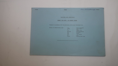
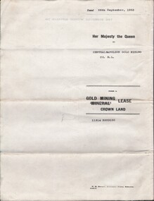
Document - MCCOLL, RANKIN AND STANISTREET COLLECTION: CENTRAL NAPOLEON GOLD MINING CO. N.L, 22nd June 1954
Document :Form A, Gold Mining Lease Crown Land 11314 Bendigo, Entered in the Register Book, Vol. 333 Fol. 138, Embossed seals of Central Napoleon and King George VI, Map: Mining District of Bendigo County of Bendigo Parish of Sandhurst, During the reign of Queen Elizabeth II, 4 pages.organization, business, industry - mining, mccoll rankin & stanistreet, mining, gold mining, central napoleon -
Beechworth Honey Archive
Hand-Written copy of Transfer of Land April 1919
Two pages included in this item. First Page: Hand-written copy of Transfer of Land. Frost (of Meldrum St, Wangaratta) to Pauline Louise Hills. £195.0.0 Parish of Mordialloc, County of Burke. Dated April 7th 1919 Second Page: Notes about agents fees. Both written with black ink on paper.hand written, hand-written, transfer, land, frost, hills, mordialloc, burke, beekeeper, beechworth honey -
 Bendigo Historical Society Inc.
Document - PETER ELLIS COLLECTION: REMARKS ON PROPOSED NATIONAL PARK AREA
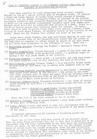
Some Introductory Remarks on the Proposed national Park Area in Parishes of Mandurang and Sandhurst printed on white A4 paper. Same as 8626.446 b with two front pages and the bottoms of some pages missing. An extra page at the end is titled POACEAE of the Bendigo Area. It lists grasses and reeds with their common names and scientific names.bendigo, parks and gardens, national parks, peter ellis collection, wild flowers -
 Bendigo Historical Society Inc.
Document - PETER ELLIS COLLECTION: REMARKS ON PROPOSED NATIONAL PARK AREA
Some Introductory Remarks on the Proposed National Park Area in Parishes of Mandurang and Sandhurst printed on yellow foolscap paper. Short description of the area. Common names and scientific names of many plants that grow in the area. Some descriptions and localities mentioned. 4 1/2 pages of species (249) and families (56) mentioned.bendigo, parks and gardens, national parks, peter ellis collection, wild flowers -
 Warrnambool and District Historical Society Inc.
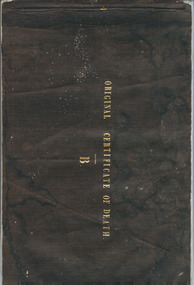
Booklet, Original Certificate of death 1853-1854, Mid 19th century
These certificates of death are original and give details of 47 deaths from July 1853 to February 1855 with the deaths mostly from the Villiers district in the Parish or Township of Warrnambool. The deaths have been registered by John Martin Ardlie and the doctors’ signatures include those of Isaac Corney and Berkeley Hutchinson. This booklet is of high significance as many of the deaths recorded herein are not registered anywhere else and some were buried in the Warrnambool Cemetery before official records began. The Warrnambool Cemetery was gazetted in June 1854. The certificates were found in a private house in Warrnambool.This is a bound booklet with a black linen cover and containing 40 pages. The pages are designed to have the information written twice with one section called the Counterpart and the second called the Original Certificate of Death (Schedule B). The counterpart section was meant to be kept in the booklet and the second section was to be cut out and sent or put elsewhere. The first seven pages have the one Counterpart section and the rest are complete with the two sections. The pages are blue with printed headings for the Registrar of Deaths to fill in. The information on 12 of the pages are incomplete and the entries are handwritten in ink. Front cover: Original Certificate of Death, Bwarrnambool cemetery, early warrnambool death records 1853-1854, john martin ardlie, warrnambool history, isaac corney, berkeley hutchinson -
 Eltham District Historical Society Inc
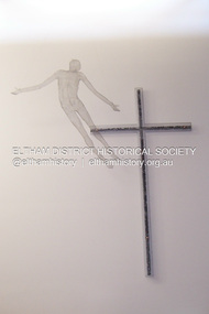
Photograph - Digital Photograph, Marguerite Marshall, Resurrection of Christ. Altarpiece, Charles Rocco (2002); Our Lady Help of Christian's Church, Henry Street, Eltham, 11 October 2006
This alterpiece by Charles Rocco was created with wire mesh, river stones and copper. 500 x 200 x 150cm. It was commissioned by the Catholic parish in Eltham (Our Lady Help of Christian's) in 2002 Published: Nillumbik Now and Then / Marguerite Marshall 2008; photographs Alan King with Marguerite Marshall.; p81This collection of almost 130 photos about places and people within the Shire of Nillumbik, an urban and rural municipality in Melbourne's north, contributes to an understanding of the history of the Shire. Published in 2008 immediately prior to the Black Saturday bushfires of February 7, 2009, it documents sites that were impacted, and in some cases destroyed by the fires. It includes photographs taken especially for the publication, creating a unique time capsule representing the Shire in the early 21st century. It remains the most recent comprehenesive publication devoted to the Shire's history connecting local residents to the past. nillumbik now and then (marshall-king) collection, art, our lady help of christian’s church, charles rocco, eltham, resurrection of christ, sculpture -
 Greensborough Historical Society
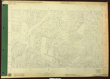
Map, Melbourne and Metropolitan Board of Works. Survey Division, MMBW, Yarra 2500 / 14.21. St Helena, Weidlich Road, 1979_08
Melbourne and Metropolitan Board of Works. Yarra 2500 [base map] 14.21. St Helena, Weidlich Road. Parish of Nillumbik 3310. Municipality of Diamond Valley 257. Prominent streets St Helena Road, Weidlich Road, Karingal Drive and Progress Road. Features include the Blair Reserve.MMBW Map in 1:2500 [scale] series. Cream parchment with green tape reinforcing on edges and punched holes on left edge.mmbw, melbourne and metropolitan board of works, shire of diamond valley, st helena - maps -
 Uniting Church Archives - Synod of Victoria
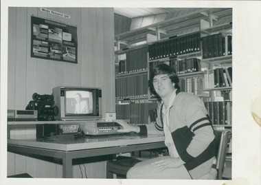
Photograph, Lindsay Carey and Theological Hall video equipment, 1984
"Co-ordinator of the equipment is Mr. Lindsay Carey, a candidate for the ministry, who said: 'It is not only the staff's responsibility at the theological hall to take video seriously, but the whole church's. Video is an excellent educational method and a superb medium for communicating the gospel — every parish should have a video cassette recorder.'Carey is shown in the Theological Hall Library with the video equipment.C&N identification.theological hall, video education, carey, lindsay -
 Kew Historical Society Inc
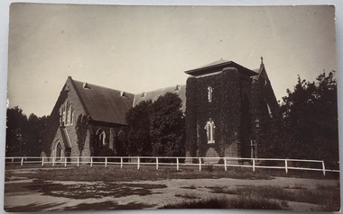
Postcard, Holy Trinity Church, 1905-1913
Holy Trinity Anglican Church is one of the parishes of the Diocese of Melbourne in the Anglican Church of Australia. Services of worship began in this building in March, 1863. The Vicarage was built in 1873, and both carry National Heritage classifications. The church contains many stained glass windows dating from the 19th century.Monochrome postcard showing the exterior of Holy Trinity Church, High Street, Kew. The western exterior of the church is viewed from High Street, Kew. The Church is surrounded by extensive vegetation, some later removed. The postcard predates 1913 when the tower was completed."Reg-No-KHS-411. Holy Trinity Church Kew - Prior to tower completion (1913)"holy trinity church -- kew (vic.), churches -- kew (vic.), postcards -- kew (vic.), postcards -- churches (vic.) -
 Bendigo Historical Society Inc.
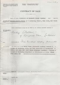
Document - H. A. & S. R. WILKINSON COLLECTION: CONTRACT OF SALE
Contract of sale dated 17th October, 1964 between Mr. J. A. Guerin (vendor) and Mr. W. Shelton (purchaser). Solicitor for vendor: Watson, James & Rogers, RACV Bldg. View Street, Bendigo. Solicitor for purchaser: Watson, James & Rogers, View Point, Bendigo. Property: Allingham Street, Kangaroo Flat being Crown allotment 18 section D Parish of Mandurang land described in Conveyance No. 390 Book 324, also Crown allotment 18 section D Parish of Mandurang comprised in certificate of title volume 1712 folio 328. Price 550 pounds. Attached Authority and Conditions for Public Auction. written in pencil on the back M. W. Smith, Kirby Street 37025 was bidding for Shelton. .organization, business, h.a. & s.r wilkinson real estate -
Southern Sherbrooke Historical Society Inc.
Information Folder - Len Jeffery
Information folder containing items pertaining to Len Jeffery. Contents: -handwritten notes by Elaine Cordell, dated 2017 -letter, Peter & Ruth Jeffery, to Phil Garland, dated 25 June 2011 -letter, Peter & June Jeffery to Elaine Cordell, dated 26 July 2011 -photocopy, A4, of photo featuring Thomas & Henry Jeffery -photocopies of death notice and short obituary, undated -photocopies (2), parish map (part) -photocopy part of allotments in Parish of Narree Worran with attached newspaper clipping -photocopy of hand-drawn map of blocks in Belgrave Heights -magazine "Yarra Valley & Ranges country life", Issue 7 Winter 2011, featuring article about Peter Jeffery, Len Jeffery's nephewlennox jeffrey, peter jeffery, belgrave heights progress association -
 Bendigo Historical Society Inc.
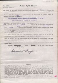
Document - MCCOLL, RANKIN AND STANISTREET COLLECTION: WATER RIGHT LICENCE NORTH DEBORAH MINING COMPANY NO LIABILITY, 19th August, 1941
4 page document plus map, Water Right Licence No. 1172, between King George VI ( the Crown ) and North Deborah Mining Company No Liability, Parish of Sandhurst., dated 19th August 1941. "to take and divert water at the points marked 'source of supply' on the said plan the quantity thereof not to exceed in the aggregate one hundred thousand gallons per diem' Plan: 'Mining District of Bendigo No. 1172 W.R., County of Bendigo, Parish of Sandhurst. Plan has dam area coloured in red, with pipe line drawn in red, leading from Battery marked on lease 11145 across lease 9988 to dam. Streets marked: Adams Road, Honeybone Street, Griston Street. (Golden Square area)bendigo, mining, north deborah mining company, north deborah mining company, adams, honeybone, and griston streets. (golden square) -
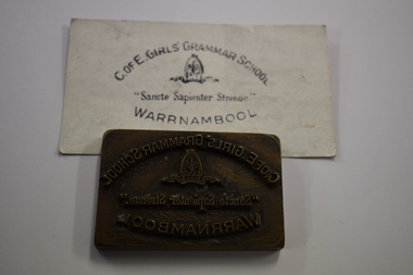 Warrnambool and District Historical Society Inc.
Functional object - School stamp, Early 20th century
This stamp comes from the Church of England Girls' Grammar School in Warrnambool which appears to have operated in the Church of England Parish Hall from 1911 to 1918. Associated with this school were the local Church of England Minister, Archdeacon Peacock and Edith Fuller, the School Principal in its later years.This stamp is of considerable significance as it an important memento of an early private school in Warrnambool.A rectangular brass block with printing and the school logo raised on the brass.C. of E. GIRLS' GRAMMAR SCHOOL " Sancte Sapienter Strenue" WARRNAMBOOLwarrnambool schools -
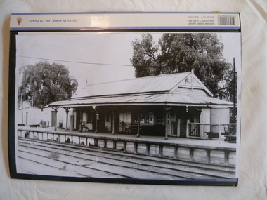 Wycheproof & District Historical Society Inc.
Railway Book, Wycheproof Railway, 2004
Friday, September 28, 1883 was a memorable date for Wycheproof as on that day was the long-awaited official opening of the railway. It was recorded that no less than 23 parishes would act as feeder to the rail line. The Railway Station closed in December 1990 but the building was renovated in 2010 with plans for a community focus and cultural events.The arrival of rail opened up the Mallee. Local farmers began sending wheat, sheep and wool by rail. Improvements to transport stock was ongoing and the eventual rail extension north of the town, resulted in a well patronised passenger service for years. Railway families and workers added to the culture of the town.Display Book of A3 size with 20 pockets of Wycheproof Rail information. It includes a collection of newspaper and magazine articles, photos, rail drawings, train calendar, paint colour legend and other rail references.sea lake, railway, rail-drawing, last-passenger- train, centenary- train, train - calendar, steaming- up- broadway, wycheproof - rail -
 Greensborough Historical Society
Map, Melbourne and Metropolitan Board of Works. Survey Division, MMBW, Yarra 2500 / 16.23. Diamond Creek, 1978_02
Melbourne and Metropolitan Board of Works. Yarra 2500 [base map] 16-23. Diamond Creek. Parish of Nillumbik 3310. Municipalities of Diamond Valley 257 and Eltham 238. Prominent streets include: Phipps Crescent, Bishop Avenue, and Reynolds Road. Includes the former Diamond Creek Technical School.MMBW Map in 1:2500 [scale] series. Cream parchment with green tape reinforcing on edges and punched holes on left edge.mmbw, melbourne and metropolitan board of works, shire of diamond valley, diamond creek - maps -
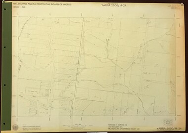 Greensborough Historical Society
Map, Melbourne and Metropolitan Board of Works. Survey Division, MMBW, Yarra 2500 / 14.24. Plenty, 1979_05
Melbourne and Metropolitan Board of Works. Yarra 2500 [base map] 14.24. Plenty. Parishes of Nillumbik 3310 and Morang 3183. Municipality of Diamond Valley 257. Prominent streets include: Heard Road, Hillmartin Road and Yan Yean Road. Features include Plenty Primary School and Plenty Park.MMBW Map in 1:2500 [scale] series. Cream parchment with green tape reinforcing on edges and punched holes on left edge.mmbw, melbourne and metropolitan board of works, shire of diamond valley, plenty - maps -
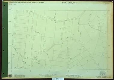 Greensborough Historical Society
Map, Melbourne and Metropolitan Board of Works. Survey Division, MMBW, Yarra 2500 / 15.27. Yarrambat, De Fredricks Lane, 1977_10
Melbourne and Metropolitan Board of Works. Yarra 2500 [base map] 15.27. Yarrambat, De Fredricks Lane. Parish of Greensborough 2724. Municipality of Diamond Valley 257 and Whittlesea 239. Prominent streets include: De Fredricks Lane, Astons Road and Bannons Lane. Features include Scrubby Creek.MMBW Map in 1:2500 [scale] series. Cream parchment with green tape reinforcing on edges and punched holes on left edge.mmbw, melbourne and metropolitan board of works, shire of diamond valley, yarrambat - maps -
 Bendigo Historical Society Inc.
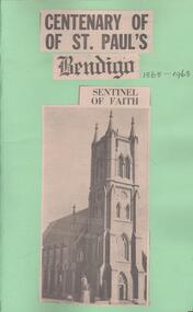
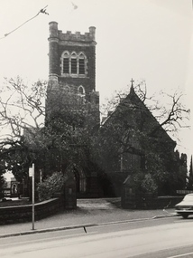
Newspaper - Lydia Chancellor collection: centenary of St. Paul's
Originally a parish church, St Paul's became a cathedral in 1981 when Bendigo was declared a separate diocese. The church, designed by Robert A Love, was dedicated in 1868, with the bells being added in 1873 and the organ in 1883. It was closed in 2009 due to safety concerns and after extensive restoration and renovation was reopened in 2016.Green folder: centenary of St. Paul's Bendigo 1868-1968. On the front a black and white photograph ot the cathedral under the title "sentinel of faith". inside the folder newspaper articles relating to the celebration of the centenary.bendigo churches, st. paul's, centenary -
 Kew Historical Society Inc
Photograph, Progress Press, Holy Trinity Church, High Street, c.1978
Holy Trinity Anglican Church is one of the parishes of the Diocese of Melbourne in the Anglican Church of Australia. Services of worship began in this building in March, 1863. The Vicarage was built in 1873, and both carry National Heritage classifications. The church contains many splendid stained glass windows dating from the 19th century.Holy Trinity Church, High Street, Kew. Inscription on reverse: "KH-224. Holy Trinity COFE Kew. Entered to the Heritage Register 1978. Photo presented by Progress Press."churches -- kew (vic.), holy trinity church -- high street -- kew (vic.) -
 Phillip Island and District Historical Society Inc.
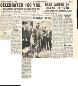
Newspaper Clipping, 100yrs Celebrations for Phillip Island, 7/11/1968
Article from a collection of newspaper clippings from October 1968 to July 1971Article about the 100yrs celebrations at Phillip Island in November 1968. Account of Back to Phillip Island 100yrs after first sub division of land at Phillip Island. Account of History of Phillip Island from discovery by Surgeon George Bass on January 5, 1979 to 1922. Account of Historical Display in the Cowes Parish Hall.phillip island, back to phillip island celebrations, surgeon george bass -
 Federation University Historical Collection
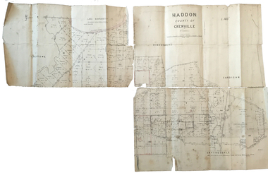
Plan, Haddon County of Grenville, 1887, 1887
Parish Plan of Haddon showing the township of Haddon, Cardigan and Haddon State Forest, Lake Burrumbeet and Nentingbook Pre-emptive Right. Names on the allotments include H. Cuthbert, B. Hepburn, T.W. Lloyd, J. Palmer, E.A. Wynne, William Collard Smith, A. Porteous, P. Russell, J. Mitchell, G. Renniehandwritten 'J. H. Cunningham Applic'haddon, cardigan, haddon state forest, lake burrumbeet, nentingbook pre-emptive right, h. cuthbert, b. hepburn, t.w. lloyd, j. palmer, e.a. wynne, william collard smith, a. porteous, p. russell, j. mitchell, g. rennie, j. noone, department of lands and survey -
 Ringwood and District Historical Society
Map, Plan of Country Lands in the Parishes of Nunawading Ringwood and Scoresby - circa 1855
Blueprint copy of Survey Map detailing original Selectors' names and property locations. List of Parish map references including property bearings, distances in Links, and markings on trees. Descriptive remarks include areas marked "Farmer's Common", "Poor soil thickly/moderately timbered with stringy bark", and location of water and firewood reserves."Surveyed and plotted by N.M. Bickford, Superintendant of Mr. Hodgkinson's Field Party". "The land comprised in this survey is of inferior quality, moderately undulating, and thickly wooded. It is watered by Dandenong Creek and Deep Creek." Inset map showing location of (*proposed) cemetery on southern corner of Lillydale Road from Melbourne and Sawmill Road, later Mount Dandenong Road. (*Cemetery did not eventuate.) -
Port Melbourne Historical & Preservation Society
Map, City of Port Melbourne. Parishes of melbourne South. Doutta Galla, c. 1930
City of Port Melbourne. Parishes of Melbourne South. Doutta Galla Copy of map circa 1930, showing Port Melbourne, Station and Town piers. Map is black on white paper with numbered red dots on most residential blocks. 1876 written in ballpoint on bottom - possibly date of first edition, before later additions.built environment, engineering department - city of port melbourne -
 Bendigo Historical Society Inc.
Document - LANDS OFFICE: AGRICULTURAL LAND LEASE REGISTER AMENDING LAND ACT 1865, 13.9.21 to 26.6.24
Document: buff leather covered journal containing rules pages with handwritten entries. Book is indexed A - Z. Across top: Register of agricultural lands leased under ' The Amending Land Act 1865' LH page: date of lease, name of lessee, county, parish, number of, extent, no. of report. Rh page: no. of report, remarks.Lands Officecottage, miners, lands act, lands office, agricultural land. amending land act 1865. -
Whitehorse Historical Society Inc.
Map, Springfield Road, Blackburn, 1924
Plan of subdivision, parts of Crown Portions 73 and 74, parish of Nunawading, County of Bourke.Plan of subdivision, parts of Crown Portions 73 and 74, parish of Nunawading, County of Bourke. Passed by MMBW 24 May 1924. Subdivision not implemented. Originally owned by Leonard Sherwin Bayley, then by Edward Henry Pearce, then by Ron Pearce. Part compulsorily acquired as site for Blackburn High School. With historical notes by Ron Pearce.Plan of subdivision, parts of Crown Portions 73 and 74, parish of Nunawading, County of Bourke. bayley, leonard sherwin, pearce, edward h, pearce, ronald harry, orchards, blackburn high school, north blackburn square shopping centre -
Whitehorse Historical Society Inc.
Newspaper - Article, Mothers in Ministry
Article in Nunawading Gazette. Rev Clemence Taplin recently took over at Holy Name Anglican Church, South Vermont. She is due to have her 2nd child in 2 months and then Rev Christine Simes will relieve her. She thinks it is probably the first occasion that two women shared the job as a Parish Priest.holy name anglican church, vermont south, churches, vermont south, taplin, clemence (rev), simes, christine (rev) -
 Bendigo Historical Society Inc.
Document - LANDS OFFICE - PLANS FORWARDED TO CROWN LANDS OFFICE, 1.9.1871 to 5.4.1880
Document: hard cover journal, brown cover with darker tan spine. 239 pages. Contains index at front of journal. Listings of plans forwarded to Melbourne Crown Lands Office by Bendigo Office. Alphabetical listing in front followed by numbered pages with individual details. Parish, county, allotment, section, surveyor, date remarks.Lands Officelands office, sandhurst, bendigo, land sales, land surveyed, plans